Caribbean Disaster
Mitigation Project
Implemented by the Organization of American States
Unit of Sustainable Development and Environment
for the USAID Office of Foreign Disaster Assistance and the Caribbean Regional Program


Caribbean Disaster
Mitigation Project |
|
This Appendix contains a description of the 100 year instrumental earthquake catalog that was assembled for this assessment, a brief history of the Jamaican seismograph network, in formation on a magnitude calibration, and a description of the Modified Mercalli and Rossi-Forel intensity scales.
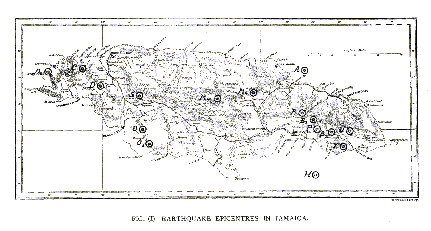
The Jamaican Earthquake catalog (Table A1.1) lists locations and magnitudes for instrumentally recorded earthquakes during the time period 1899 to 1996 within the area between 14o - 22o N and 72o - 82o W. These events are also shown in map format in Figure A1.1.
The completeness of the catalog varies considerably during the 20th Century. At the beginning of the century, only the largest events were reported - often with large uncertainties (� 1o) in location and magnitude. The 14 June 1899 earthquake for example, is located at 18o N, 77o W - directly in the center of Spanish Town (see Figure A1.1). While this event was felt through out the island, the highest reported intensity, MMI V, contradicts the reported magnitude, 7.8 and suggests a location elsewhere.
Seismic instrumentation was installed in Jamaica following the 1907 earthquake, however, these were non-calibrated, non-standardized instruments with poor time keeping (Shepherd and Aspinall, 1980).
A review of earthquakes in the International Seismological Summary (ISS) from 1913 to 1939 by Rutten and Van Raadshooven (1940) indicated a number of earthquakes with large intensities not registered by 'local' seismographs located in Tacubaya (1500 km), New Orleans (2000 km), Washington (2300 km), and Saint Louis (2700 km). These events are not listed in ISS catalogs for this period, and are not included in Table A1.1. These events include: August 19, 1914 [Rossi Forell (RF) Intensity VII]; October 14, 1914 [RF VII-VIII]; December 24, 1914 [RF VII]; November 25, 1921 [RF VII?]; and July 14, 1936 and are discussed further in Section 2 of the Final Report.
The overall accuracy of locations and the reporting of smaller earthquakes in this region improved with the advent of computerized earthquake location programs and the installation of the World Wide Standardized Seismograph Network in the 1960's. Installation of a local seismograph network on Jamaica in the 1960's and the steady improvement of that network throughout the last 30 years have enabled the recording of events too small to be detected by global networks.
The catalog in Table A1.1 combines earthquake locations and magnitudes from a number of sources covering different time periods. Our criteria for selection, when multiple earthquake locations were available, is summarized in the list below which ranks sources from highest to lowest priority for selection.
Earthquake magnitudes reported in the catalog are predominately mb or body wave magnitudes. While the lower cut off threshold is nominally M > 3.4, we have also included many events that do not have magnitude determinations. These additional events can be used to delineate active tectonic features in the region. Selection priorities range from (highest to lowest):
Magnitude determinations for specific events include
An electronic version of the Jamaican Earthquake Catalog is available as an Excel spreadsheet file in http://www.oas.org/en/cdmp/hazmap/kma.htm
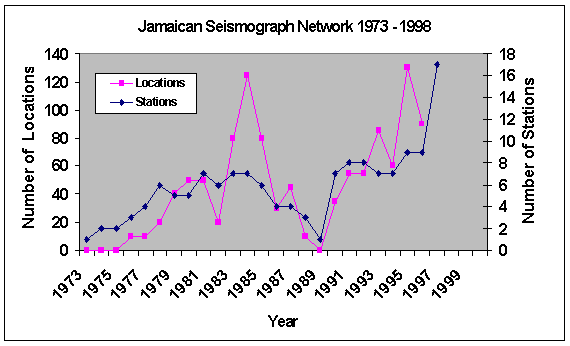
Since the late 1960's, the University of the West Indies has operated the Jamaican Seismograph Network (JSN). The JSN started with one station and had as many as nine stations operating during the first 25 years. As seen in Figure A1.2, the performance of the JSN has varied considerably during the last 30 years. Prior to 1989, Mark Products vertical 1 Hertz seismometers were used along with generic amplifiers and discriminators. The Network was telemetered to a Central Recording Site at the UWI Mona Campus. Until 1989, only analog recording was available using a pen and ink drum recorder and a 24-channel thermionics FM tape recorder. Network timing was via WWV radio broadcast.
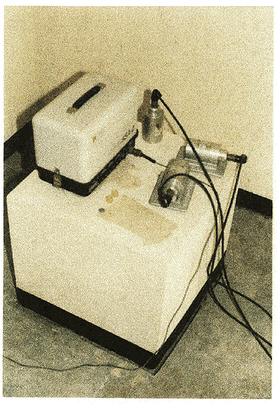
In 1990, the Central Recording Site adopted the Soufriere System (SRU, 1984, 1977) for the digital recording and playback of earthquake data. A Kinemetrics 468-DC 'GOES' (Geostationary Operational Environmental Satellite) synchronized clock provided network timing to 0.001-sec accuracy. The Soufriere System was in operation until July 1997.

Incoming seismic signals were digitized at 100 samples per second. Coda length duration magnitudes were computed using the formula
M = 2.073 log (D) + 0.0018 (R) - 0.705,
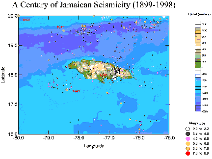
where D is the coda duration in seconds and R is the hypocentral distance in kilometers. Shepherd and Aspinall (1983) developed this relationship from an analysis of Lesser Antilles earthquakes and believed it to be equivalent to USGS mb magnitudes to within � 0.2 magnitude units. During this time, however, the JSN was uncalibrated and used low gain (56 dB) amplifiers with noisy and intermittent stations. Based on this formula, the JSN assigned a magnitude of 5.4 for the 1993 Woodford Jamaica earthquake. The corresponding ISC magnitude was 5.5. Figure A1.3 shows microearthquakes located in the vicinity of Jamaica during the period 1990 to 1996 (Wiggins-Grandison, 1997).
In early 1997, a program to improve the JSN was started. Existing equipment was replaced with Teledyne-Brown/Geotech instruments and either new or refurbished Mark Products sensors. UHF band transmitters and receivers were also installed. The new JSN currently consists of nine calibrated high-gain short-period seismograph stations (two of which are three-component stations, see Figure A1.4) and five low-gain seismometers. The network also contains three digital accelerographs, though no data from strong earthquakes have been recorded to date. Data acquisition and processing is based on software developed at the Seismological Division of the Geophysical Institute of Israel. All stations are calibrated and the response functions are known and documented. Network timing is provided using a Trimble GPS receiver.
Magnitudes used for calibration in this study date from 1978 to 1996 (the majority being from the 1990's) and were solved using JSN data. The goal was to identify larger events that were recorded both teleseismically and by the JSN and compare coda duration magnitudes with reported mb values. Low rates of moderate earthquake activity and the intermittent status of the JSN limited the number of events available for comparison during this time. There are about 68 teleseismically recorded events in the Jamaica region between 1970 and 1989, as listed in the Pan American Institute of Geography and History (PAIGH) catalog (Shepherd et al., 1994). One third of these events occurred prior to 1977, unfortunately, no coda magnitudes are available for that time period. Between 1980 and 1985 there were 27 events, many of which have either coda magnitudes or mb magnitudes, but not both. Many events occurring between 1986 and 1989 were not recorded due to network problems, see Figure A1.2.
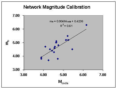
Table A1.2 lists 18 earthquakes for which coda duration and mb magnitudes are available. Except for those marked GWJ, the coda magnitudes were determined from the station Stony Hill (STH) which is the most consistently used station over the duration of the catalog, 1978 to 1996. These data are plotted in Figure A1.5.
Event ID |
Coda (sec) |
Distance (km) |
Mcoda |
mb |
Notes |
| 9005222035 | 254 |
207 |
4.7 |
5.1 |
STH |
| 9005300239 | 638 |
79 |
5.3 |
5.2 |
STH |
| 9009040803 | 463 |
174 |
5.1 |
5.2 |
STH |
| 9010301234 | 222 |
217 |
4.6 |
4.6 |
STH |
| 9010310331 | 285 |
201 |
4.8 |
4.8 |
STH |
| 9205251655 | 1354 |
214 |
6.2 |
6.3 |
STH |
| 9207241858 | 199 |
145 |
4.3 |
4.5 |
STH |
| 9211062220 | 180 |
157 |
4.3 |
3.7 |
STH |
| 9211070317 | 245 |
179 |
4.6 |
4.7 |
STH |
| 9301131711 | 713 |
3 |
5.2 |
5.5 |
GWJ |
| 9402152258 | 158 |
17 |
3.9 |
3.9 |
GWJ |
| 9406040725 | 600 |
219 |
5.5 |
4.5 |
STH |
| 9506032142 | 162 |
7 |
3.9 |
3.8 |
GWJ |
| 9509080708 | 257 |
128 |
4.5 |
4.3 |
STH |
| 9512241713 | 261 |
232 |
4.7 |
3.8 |
STH |
| 9607021409 | 227 |
139 |
4.4 |
4.4 |
STH |
| 9610091926 | 184 |
58 |
4.1 |
4.7 |
STH |
250 |
207 |
4.6 |
5.0 |
MM |
I |
II |
III |
IV |
V |
VI |
VII |
VIII |
IX |
X-XII |
RF |
I |
I-II |
III |
IV-V |
V-VI |
VI-VII |
VIII- |
VIII+ to IX- |
IX+ |
X |
Masonry A- Good workmanship, mortar and design; reinforced, especially laterally, and bound together by using steel, concrete, etc.; designed to resist lateral forces.
Masonry B- Good workmanship and mortar; reinforced, but not designed to resist lateral forces
Masonry C- Ordinary workmanship and mortar; no extreme weaknesses like failing to tie in at corners; but neither reinforced nor designed against horizontal forces.
Masonry D- Weak materials, such as adobe; poor mortar; low standards of workmanship; weak horizontally.
| CDMP home page: http://www.oas.org/en/cdmp/ | Project Contacts | Page Last Updated: 20 April 2001 |