Caribbean Disaster
Mitigation Project
Implemented by the Organization of American States
Unit of Sustainable Development and Environment
for the USAID Office of Foreign Disaster Assistance and the Caribbean Regional Program


Caribbean Disaster
Mitigation Project |
|
Development of a probabilistic seismic hazard assessment for the Kingston Metropolitan Area involved the specification of all seismic sources within 200 kilometers of the Kingston area. The following sections summarize earthquake and geologic history of Jamaica and the Kingston Metropolitan area and describe the seismotectonic setting of Jamaica and the northern Caribbean region. The model presented in this study relies on the integration of existing seismologic and geologic information, as well as newly acquired regional geodetic data from Global Positioning System (GPS) studies of the northern Caribbean. This information is best presented in the framework of plate tectonics and its application to Jamaica. Therefore, we will utilize information from active onland faults, marine geophysical studies of the offshore region, and geodetic and geophysical information on the rates of fault movement to develop a seismotectonic model for Jamaica and the surrounding regions. This model is used as input to the probabilistic seismic hazard assessment discussed in Section 3.
The Tomblin and Robson (1977) catalog of Jamaican earthquakes from 1564 to 1971 is the primary resource for historic seismicity. It lists 357 earthquakes and more than 1000 intensity reports for this time period. Earthquake intensity scales, such as Rossi-Forel and Modified Mercalli, were intended to describe and categorize the effects of earthquakes on the built environment. In contrast, magnitude is a measure of the physical size and energy released in an earthquake. Complete descriptions of both the Rossi-Forel (RF) and Modified Mercalli (MMI) scales are located in Appendix 1. The following represents a brief overview of the significant earthquakes to affect the Kingston Metropolitan area in historic times.
While the history of the largest, damaging events extends back 300+ years, records of smaller events are only available for the last 150 years. The reporting of felt events (MMI > IV) in Kingston area appears to be consistent since 1820, coincident with the appearance of daily newspapers in the West Indies. A catalog of MMI >V events is judged complete for the entire island from 1880 to the present (Shepherd and Aspinall, 1980). A sharp rise in the number of events from 1880 to 1920 occurs during the time that Maxwell Hall published his catalog. Filtering of events with MMI >VI, however, still shows an increase associated with the 1907 earthquake and its aftershocks. Shepherd and Aspinall (1980) note that the numbers of felt earthquakes (MMI >V) in both Kingston and the rest of the island have been in decline since about 1930, and are at the lowest level since the beginning of the 19th century. This is especially significant since the major policy decisions made about building codes, earthquake hazard mitigation and major redevelopment of the Kingston area were done during a period of relatively low seismicity.
Montessus de Ballore (1903, 1906) and Taber (1920, 1922 a, b) were among the first to argue that the locations of epicenters in the West Indies were related to major fault zones with strong topographic relief. As seen in Figure 1.1, the Bartlett (Cayman) Trough is the major bathymetric feature in this region. It also defines the northern boundary of, what is now known as, the Caribbean Plate.
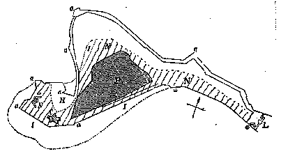
Taber (1920) proposed that the large earthquakes of Jamaica in 1692 and 1907 had their origin on the north side of the island, on the south slope of the Bartlett Trough. This location was based on his interpretation on high intensities and reports of a tsunami on the north side of the island (Buff and Annotto Bay, see Figure 1.1). Reid (in Taber, 1920) estimated the latitude of the 1907 shock to be at 18.2 N, based on S-P times recorded on a seismograph at the US Weather Service in Washington, DC. 18.2 N is 3 km south of Buff Bay. Taber uses this location in support of a north coast epicenter, however, it just as easily supports an on-island epicenter, though no surface faulting was found. Hall (1923), on the other hand, places his epicenter "H" (location of the 1907 earthquake) south of Kingston, near what is now known as the Yallahs Basin (see Figure A1.0). Davidson (1907) argues that that hypocenter was close to Kingston and shallow, based on the "extremely" local character of the destruction and the minor character of the disturbances registered by seismograph stations in Washington, Shide, and Edinburgh. The magnitude reported for the 1907 shock is 6-6.5 (Bath, 1979, Miyamura, 1988).
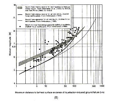
Some geologic constraints on the distance between the 1907 earthquake and Kingston are available using liquefaction and ground failure features. Figure 2.3 shows relationships between earthquake magnitude and the maximum hypocentral distance to the farthest surface evidence of liquefaction for a number of earthquakes (Obermeier and Pond, 1999). The published magnitude for the 1907 earthquake, M = 6-6.5, suggests distances of less than 50 km from the Kingston Harbor/ Palisadoes area (using the thick boundary curve in Figure 2.3).
Examination of felt reports and instrumental epicenters by Rutten and Raadshooven (1940) indicated that felt earthquakes in Jamaica were not solely confined to the Bartlett Trough (as suggested by Taber, 1920) but had epicenters elsewhere in the region as well. The 1914 earthquake in Blue Mountains demonstrated the capability of on-island faults to produce locally damaging earthquakes. Relocation of both the 1907 Kingston and 1957 Montego Bay epicenters to onland locations by Sykes and Ewing (1965) also highlighted the capability of local faults as seismogenic sources. The installation of seismograph networks by the Seismic Research Unit, UWI and its successor, The Earthquake Unit, UWI, has documented the level of small earthquake activity in the immediate vicinity of Kingston (see Figure A1.3). Most recently, the M 5.4 1993 Woodford earthquake caused MMI VII damage in the Kingston metropolitan area and has focused renewed attention on the activity of on-island faults in eastern Jamaica in the vicinity of Kingston (Wiggins-Grandison, 1996).
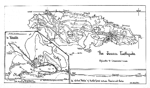
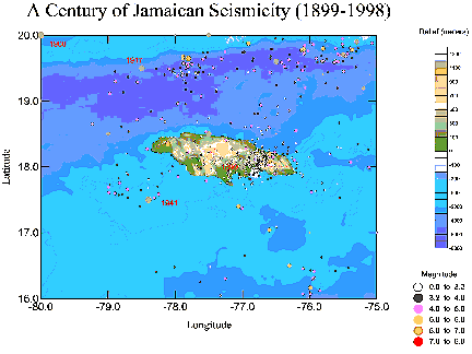
Figure 2.4 shows the seismicity of Jamaica and surrounding regions from 1899 to 1998. As explained in Appendix 1, the catalog covers different time periods with varying degrees of completeness in coverage in magnitude and location. Notable concentrations of seismic activity include the north wall of the Cayman Trough with large (M>7) events in 1900 and 1917. This marks the location of the North American/Caribbean (Gonave) plate boundary. In eastern Jamaica and the Blue Mountains, the large concentration of smaller events reflects local network coverage in this region. The location of the M 7.8 1899 earthquake at 18 N, 77 W contradicts the moderate intensities reported for this event (MMI V) and illustrates the large uncertainties associated with earthquake locations at the beginning of the century. Scattered seismicity in western Jamaica includes the 1957 M 6.5 Montego Bay earthquake. To the southwest, a cluster of activity near Pedro Banks includes the M 7.1 1941 event. Compare instrumental seismicity in Figure 2.4, with the map of earthquake felt reports in Figure 2.5 for the period 1880 to 1960 (Shepherd and Aspinall, 1980). The two highest concentrations of felt reports - Kingston and western Jamaica, near Santa Cruz occur in the vicinity of the two largest topographic provinces/features on the island - the Blue Mountains and the Santa Cruz/Don Figuerero Mountains, respectively.
The oldest rocks on Jamaica are of Cretaceous age (136 - 65 Million years, Ma). During that period the northern part of the Nicaragua Rise, of which Jamaica is a part, was enveloped in large scale volcanic activity and deformation of sediments associated with a nearby subduction zone. The geologic complexity of this basement rock, exposed in only a few inliers on the island, makes regional correlation difficult. It is clear, however, that this basement rock underlies all of the younger limestones. Later, in Paleocene time (65 - 54 Ma), volcanic activity ceased and the convergent plate margin transformed into an extensional/shear tectonic environment. It is at this time that Jamaica developed its present block and graben structure, being broken along major northwest-southeast fault systems. Belts flanking the 6 prominent blocks of the islands are fault controlled and appear to have formed in association with crustal extension north and west of the island that later led to the development of the Cayman spreading center.
After this period, Jamaica entered a prolonged epoch of tectonic quiescence, during which a thick mantle of limestone was deposited over the older rocks and the island subsided, accumulating up to 2.7 km of platform carbonates (Lewis and Draper, 1990). This is similar to northern Puerto Rico, where Birch (1986) ascribed subsidence to cooling of the arc massif after the cessation of volcanism. Perhaps a similar cooling-driven subsidence event occurred in Jamaica between 50 and 20 Ma ago.
The present tectonic regime started in the Late Miocene after approximately 30 million years of tectonic quiescence. Several events point to the beginning of the most recent tectonic period at 9-10 Ma:
In terms of plate tectonics, Jamaica lay within the stable area of the Caribbean Plate from the Paleogene through Lower Miocene. The stable environment led to gradual cooling and subsidence of the island, deposition of thick sequences of limestones, and limited faulting activity. Jamaica probably resembled the present day Pedro Bank or other banks along the Nicaragua Rise. In Mid-Miocene time, about 9 Ma, Jamaica was once again near an active plate boundary. This time the boundary was between the Caribbean Plate and a recently sheared off sliver from that plate called the Gonave microplate. The Gonave microplate developed in response to the collision of the Caribbean plate with the Bahamas platform 1000 kilometers to the east, near Puerto Rico and Hispaniola (Mann et al., 1995 and McCann, 1999).
Miocene to Recent deformation includes east-west left-lateral transcurrent faults, northeast-southwest trending normal faults, and northwest-southeast trending reverse faults and folds (Lewis and Draper, 1990). These structures developed in a zone of east-west trending left-lateral shear caused by movement between the Caribbean Plate and Gonave Microplate. Jamaica's existence as an island is due primarily to the deformation, uplift and faulting caused by these plate movements. The uplift of the Blue Mountains is in response to a right-lateral bend in one of those fault systems, however, there are no geodetic or Global Positioning System (GPS) measurements to verify the present day rates of uplift.
The geology of the Kingston Metropolitan area consists of Liguanea Alluvium on the plains to the south and bedrock in the mountainous northern parts of St. Andrew. The alluvium is Pleistocene sand and gravel interbedded with silts and clays. The Palisadoes tombolo, on which is sited the town of Port Royal and the Norman Manley International Airport is made up of discontinuous coral reefs connected by sands and gravels deposited by longshore drift from the estuaries of the Hope, Cane, Yallahs and Morant Rivers to the east of Kingston. Along the coast, there is also artificial fill or man-made ground in parts of downtown Kingston, Kingston Harbor, the industrial zone and the airport. These areas are discussed in more detail in Section 4.
Bedrock outcropping in the hills north and east of Kingston consists of Tertiary limestones and clastic sedimentary and volcanic rocks. Much of this is extensively faulted. The southern part of the Wagwater Trough and westernmost extension of the Plantain Garden fault system separates the Liguanea Plain from these outcrops. Based on the youthful appearance of Dallas and Long Mountains, one can say that the faulting and folding processes that formed these and the rest of the Blue Mountains is undoubtedly occurring today beneath the eastern KMA, however, there are no measurements to verify the current rates of activity. Slip at depth along blind thrusts may explain why no surface faulting has been observed in previous damaging earthquakes.
Previous studies have developed probabilistic seismic hazard assessments based on macroseismic catalogs (Shepherd and Aspinall, 1980) or regional teleseismic catalogs (Shepherd et al., 1994, 1999). While earthquake catalogs, be they of teleseismic, local or historic events, are guides to future earthquake activity, there are some important caveats that need to be addressed:
Shepherd et al. (1994) developed a regional earthquake catalog, which they assumed to be complete for events with M > 4.5 since the 1960's. This catalog is temporally coincident with the lowest rate of earthquake activity in historic times (Shepherd and Aspinall, 1980). Shepherd et al. (1997) recognized the implications of associating seismicity with geologic features and the localization of seismic activity and strong ground motion, but chose not to identify individual faults as earthquake sources. We feel that the historic, teleseismic and local catalogs should be used as checks and guides to any proposed model, but that ground motion models should not be based on that information alone.
This is not to say that physically based models are without uncertainties. The identification of Holocene active faults, understanding their tectonic history and rates of fault motion are all critical elements and are currently poorly understood in Jamaica. The location of Jamaica within a plate boundary zone, allows for the development and application of a plate tectonic model which can provide a framework for the future improvement of seismic hazard models through scientific research programs that can address specific issues and reduce uncertainties in the analysis.
In this study, active faults are defined as those structures which exhibit demonstrable offset during the last 10 my. Individual faults and their rates of motion are discussed in the following sections. As noted before, for the past 9 Ma Jamaica lay along junction of the southern margin of the Gonave microplate and the northern margin of the Caribbean Plate. Major, well identified, strike-slip fault systems lay in the submarine areas east, west, and north of the island. Those fault systems appear to be relatively simple in form, exhibiting few offsets or complications. Jamaica, however, represents an abrupt offset in this otherwise simple fault system. The islands lies in a restraining bend along the 600-km long fault zone (Figure 2.6) that has been suggested to mark the southern boundary of the Northern Caribbean Plate Boundary Zone (Mann et al., 1985).
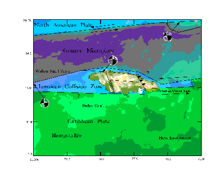
The fault system of interest to us begins in SW Haiti and the Dominican Republic as the Enriquillo Fault zone, crosses the Jamaica Passage, and enters Jamaica near its southeastern tip as the Plantain Garden Fault Zone (Figure 2.6). In Haiti, the Enriquillo Fault Zone is associated with damaging earthquakes in 1751, 1770, and 1860 (Kelleher et al., 1973).
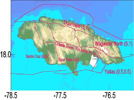
The Morant Trough (Figure 2.7) is an active pull-apart basin between Haiti and Jamaica (Mann et al., 1990). The location of this feature will limit length of earthquake rupture on eastern segment of the Plantain Garden Fault. Just north of Kingston and west of the Blue Mountains, this fault system continues as the Rio Minho-Crawle River Fault Zone. The transition from the Plantain Garden to the Rio Minho is through a restraining bend marked by the uplift of the Blue Mountains. The most probable westernmost continuation for this major fault system is the Duanvale Fault and its extension off the northwest corner of the island. While the exact location of the 1957 Montego Bay earthquake is uncertain, an earthquake focal mechanism for this event by Frankel (1984) shows left-lateral strike slip motion on an east-west trending fault plane (see Figure 2.6).
These facts lead one to the inescapable conclusion that the island is traversed, in one fashion or other, by a major system of faults. Burke et al (1980), Draper (1979), Green (1977), Mann et al (1985, 1990) and Wadge and Dixon (1984) have studied active faults in Jamaica. Their information serves as the basis for the development of the on island portion of the Jamaican tectonic model.
Other, probably secondary but nonetheless important, fault zones are known to exist near the Yallahs Basin and in the Spur Tree, Santa Cruz Mountains portion of SW Jamaica. Large numbers of felt earthquakes and large topographic relief (see Figures 2.4 and 2.5) require that both of these systems be included in the tectonic model for completeness.
To the west of Jamaica there is one major fault zone, the Walton Fault, which continues westerly to the southern termination of the Cayman Ridge. We assume here that slip along the faults cutting Jamaica, eventually merges again to occur along one feature, the Walton Fault. So to both the east and west of Jamaica there are relatively simple strike-slip faults defining the southern margin of the Gonave microplate. Jamaica, however, is cut by a complex system of faults joining those two fault systems.
Rate of fault motion can be estimated by several means -
Enriquillo Plantain Garden Fault- Direct measurements of rates of fault motion along the Plantain Garden Fault are unknown, as is the earthquake history. Offsets of geologic features provide long-term estimates of the rate of fault motion. Mann and others (1985), Van den Bold (1975), and Calmus (1983) use a 25-30 km offset to get a rate of 5-6mm/yr in 5 Ma.
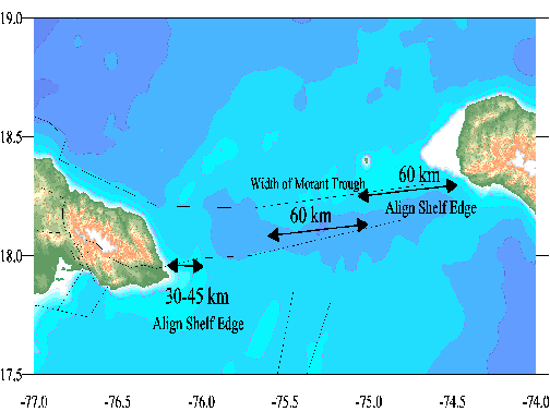
The Morant Trough, while a complicated submarine feature, also lends some limits on rates of movement on the Enriquillo-Plantain Garden Fault Zone. Mann et al. (1995) note that this extensional feature represents a pull-apart basin along the Enriquillo-Plantain Garden fault system, thus its dimensions lead to an estimate of total fault slip. The width of the deepest part of the trough is about 60 km. Also, the amount of offset of the shelf edge at the westernmost extension of the Haitian Peninsula is also 60 km. If these offsets and structures developed during the last 9 Ma, then a rate of fault slip of about 6mm/yr is found. The offset of the shelf-edge along the Plantain Garden Fault off eastern Jamaica leads to a slightly lower slip rate of 3- 4.5 mm/yr.
Wagwater Fault-Heubeck and Mann (1991) cite Green (1977) for information on Wagwater Fault. It is a 200-500m wide, reverse fault dipping 57o. The youngest rocks deformed by it are Pliocene in age. Compared with the Enriquillo-Plantain Garden Fault Zone in Haiti (1.5km wide) and in the Dominican Republic (1-3 km wide), this is a relatively narrow fault zone. Wadge and Dixon (1984) indicate a complex scissors type movement with a NW-SE strike.
Cayman Spreading Center and Oriente Fracture Zone- The Oriente Fracture Zone [Bartlett Trough] is by far the most active tectonic feature in the region. It defines the northern boundary of the Caribbean plate and the Gonave microplate. It often dominates the seismicity of Jamaica during local quiet periods. Strong earthquakes originating from the Oriente Fracture Zone have been felt on the island of Jamaica. Recently, a M 6.5 (Ms 6.9) event in 1992 on the Oriente Fracture Zone caused MMI IV damage in Kingston. As discussed previously, the Bartlett Trough was believed to be the major geologic feature responsible for the historic, high intensity earthquakes experienced on the island (i.e., 1692 and 1907). While this correlation has been questioned in recent years, it nevertheless, is a potential threat to the island.
Ladd et al. (1990) cite Rosencrantz et al. (1988) as calculating spreading rate for Cayman Ridge at 15mm/yr for 0 to 26 Ma and 25-30 mm/yr for 26 to 50Ma. This same rate of slip would apply to the Oriente Fracture Zone.
Hess Escarpment and Nicaraguan Rise-The Hess Escarpment is a major feature of the Caribbean seafloor, extending from South America northeasterly to Hispaniola. Holcombe et al. (1990) suggest the Nicaraguan Rise including the Hess Escarpment, Haiti, Central America and the eastern part of Jamaica is presently activated by left lateral slip and spreading. The Jamaican Seismograph Network has picked up swarms of M 4 to 5 earthquakes from time to time, the latest being in 1994. These swarms are often not reported in any of the international databases. None of these events have been felt on the island of Jamaica. The Hess Escarpment has also produced a number of M 5 and larger earthquakes offshore southern Haiti. Farther to the West, extension of the Enriquillo fault continues offshore of the north coast of Jamaica (ON in Figure 2.8) with a slip rate of 1 mm/yr. To the west it merges into the Walton fault zone in some unknown fashion.
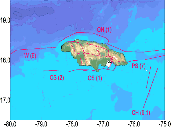
So, of the 6 to 8 mm/yr slip presumed for the fault system dividing the Gonave microplate from the Caribbean Plate, 1mm/yr is assumed to pass along the northern coast of the island, leaving 5 to 7 mm/yr slip to be accounted for within the island of Jamaica itself, and along the south coast.
Onshore in southeastern Jamaica, the east-west striking Plantain Garden Fault moves 5 to 7mm/yr along its length. The fault segment to the west, in the Blue Mountains, changes strike and motions are divided along several faults. We assume the following motions: Dallas Mountain: 1mm/yr; Long Mountain: 1mm/yr; Wagwater; 2mm/yr; Plantain Garden: 3mm/yr; J fault: 2 mm/yr; Yallahs Basin Faults: 0.5mm/yr each. While the exact amount of slip for each of these faults in not well controlled, we feel that the total amount of slip entering the island through the Plantain Garden Fault is reasonably well constrained.
Slip from the Yallahs Basin faults continues along the South Coast faults at a rate of 1mm/yr, and to the west this slip merges into the Walton Fault Zone in some unknown fashion.
West of the Blue Mountains, on-land fault motion appears to be divided between two fault systems, the Crawle River-Rio Minho fault system and the Duanvale fault system (see Figure 2.9). As noted before, we do not a priori know how to divide this slip. We, therefore, developed a worst and best case model of slip for the KMA area (see Figure 2.9). For an 8 mm/yr total slip in the Jamaica region, the worst case is one in which 5mm/yr occur along the Crawle River-Rio Minho fault system, 1mm/yr along the Duanvale fault system along the north coast, 1 mm/yr offshore from the north coast, as well as 1 mm/yr offshore from the south coast (model 151). The best case is just the opposite, the closer Crawle River- Rio Minho fault system only moves 1 mm/yr, while the northerly Duanvale system moves at a rate of 5mm/yr (model 511). These two differing assumptions naturally have implications for slip rates on other faults in Central and Western Jamaica. The details of fault slip for the two models are given in Table 2.1.
For the 16 cases in which total slip for the Jamaica region is only 6 mm/yr, fault slip rates in all models (e.g. 151, 511) were reduced by 25% when compared to the corresponding 8 mm/yr models.
Fault Name |
Fault ID |
Longitude |
Latitude |
Length (km) |
Strike |
Model 511 rate (mm/yr) |
Model 151 rate (mm/yr) |
Mo |
Slip (m) |
Km to KMA |
ch1 |
-75.230 |
17.800 |
122 |
25 |
0.1 |
0.1 |
7.8 |
2.9 |
170 |
|
ch2 |
-75.700 |
16.800 |
177 |
|||||||
ch3 |
-75.450 |
17.850 |
63 |
15 |
0.1 |
0.1 |
7.3 |
1.5 |
145 |
|
ch4 |
-75.600 |
17.300 |
150 |
|||||||
Plantain Garden |
pn1 |
-74.650 |
18.300 |
112 |
85 |
4.0 |
4.0 |
7.7 |
2.7 |
236 |
pn2 |
-75.700 |
18.200 |
119 |
|||||||
on1 |
-75.700 |
18.200 |
60 |
91 |
1.0 |
1.0 |
7.3 |
1.4 |
119 |
|
on2 |
-76.270 |
18.210 |
58 |
|||||||
on2 |
-76.270 |
18.210 |
65 |
109 |
1.0 |
1.0 |
7.3 |
1.5 |
58 |
|
on3 |
-76.850 |
18.405 |
46 |
|||||||
on3 |
-76.850 |
18.405 |
10 |
25 |
1.0 |
1.0 |
6.1 |
0.2 |
46 |
|
on4 |
-76.810 |
18.490 |
55 |
|||||||
on4 |
-76.810 |
18.490 |
13 |
125 |
1.0 |
1.0 |
8.0 |
4.5 |
55 |
|
on5 |
-76.910 |
18.560 |
47 |
106 |
65 |
|||||
on6 |
-77.340 |
18.680 |
54 |
92 |
100 |
|||||
on7 |
-77.850 |
18.695 |
41 |
69 |
145 |
|||||
on8 |
-78.210 |
18.560 |
26 |
63 |
174 |
|||||
on9 |
-78.430 |
18.450 |
193 |
|||||||
Walton |
w19 |
-79.200 |
18.400 |
79 |
90 |
1.0 |
1.0 |
7.5 |
1.9 |
276 |
w20 |
-78.450 |
18.400 |
194 |
|||||||
ps1 |
-74.800 |
18.150 |
128 |
82 |
4.0 |
4.0 |
7.8 |
3.1 |
217 |
|
ps2 |
-75.700 |
18.000 |
||||||||
Plantain Garden |
ps2 |
-75.700 |
18.000 |
32 |
88 |
7.0 |
7.0 |
7.5 |
1.8 |
|
ps3 |
-76.000 |
17.990 |
29 |
81 |
83 |
|||||
Plantain Garden |
p1 |
-76.270 |
17.945 |
8 |
101 |
54 |
||||
p2 |
-76.345 |
17.960 |
8 |
82 |
45 |
|||||
p3 |
-76.420 |
17.950 |
37 |
|||||||
Plantain Garden |
p3 |
-76.420 |
17.950 |
13 |
106 |
3.0 |
3.0 |
7.1 |
1.0 |
37 |
p4 |
-76.540 |
17.985 |
12 |
127 |
23 |
|||||
p5 |
-76.625 |
18.050 |
7 |
103 |
15 |
|||||
p6 |
-76.690 |
18.065 |
10 |
108 |
10 |
|||||
p7 |
-76.780 |
18.095 |
3 |
101 |
11 |
|||||
p8 |
-76.805 |
18.100 |
13 |
Fault Name |
Fault ID |
Longitude |
Latitude |
Length (km) |
Strike |
Model 511 rate (mm/yr) |
Model 151 rate (mm/yr) |
Mo |
Slip (m) |
Km to KMA |
Wagwater |
ws1 |
-76.630 |
17.875 |
6 |
151 |
2.0 |
2.0 |
6.7 |
0.6 |
19 |
ws2 |
-76.655 |
17.920 |
5 |
144 |
14 |
|||||
ws3 |
-76.680 |
17.955 |
5 |
143 |
9 |
|||||
ws4 |
-76.710 |
17.995 |
9 |
140 |
4 |
|||||
j3 |
-76.760 |
18.055 |
6 |
|||||||
j1 |
-76.675 |
18.010 |
6 |
121 |
2.0 |
2.0 |
6.4 |
0.4 |
8 |
|
j2 |
-76.725 |
18.040 |
4 |
113 |
5 |
|||||
j3 |
-76.760 |
18.055 |
2 |
104 |
6 |
|||||
j4 |
-76.780 |
18.060 |
4 |
172 |
7 |
|||||
j5 |
-76.785 |
18.095 |
11 |
|||||||
Long Mt. |
l1 |
-76.775 |
18.020 |
5 |
153 |
1.0 |
1.0 |
6.1 |
0.2 |
4 |
l2 |
-76.755 |
17.980 |
6 |
117 |
2 |
|||||
l3 |
-76.705 |
17.955 |
7 |
|||||||
Wagwater |
wn1 |
-76.815 |
18.230 |
4 |
23 |
5.0 |
1.0 |
6.4 |
0.3 |
27 |
wn2 |
-76.830 |
18.195 |
4 |
0 |
23 |
|||||
wn3 |
-76.830 |
18.160 |
4 |
164 |
20 |
|||||
wn4 |
-76.820 |
18.125 |
3 |
149 |
16 |
|||||
p8 |
-76.805 |
18.100 |
13 |
|||||||
Duanvale |
du1 |
-76.820 |
18.240 |
23 |
109 |
5.0 |
1.0 |
7.0 |
1.0 |
28 |
du2 |
-77.025 |
18.310 |
7 |
103 |
46 |
|||||
du3 |
-77.090 |
18.325 |
7 |
104 |
52 |
|||||
du4 |
-77.150 |
18.340 |
5 |
69 |
58 |
|||||
du5 |
-77.190 |
18.325 |
61 |
|||||||
Duanvale |
du5 |
-77.190 |
18.325 |
9 |
121 |
5.0 |
2.0 |
7.4 |
1.6 |
61 |
du6 |
-77.265 |
18.370 |
4 |
97 |
70 |
|||||
du7 |
-77.305 |
18.375 |
6 |
110 |
74 |
|||||
du8 |
-77.360 |
18.395 |
6 |
85 |
81 |
|||||
du9 |
-77.420 |
18.390 |
8 |
101 |
86 |
|||||
du10 |
-77.495 |
18.405 |
2 |
149 |
94 |
|||||
du11 |
-77.504 |
18.420 |
12 |
97 |
96 |
|||||
du12 |
-77.620 |
18.435 |
14 |
86 |
108 |
|||||
du13 |
-77.750 |
18.425 |
4 |
117 |
121 |
|||||
Duanvale |
du13 |
-77.750 |
18.425 |
4 |
117 |
5.0 |
3.0 |
6.5 |
0.4 |
121 |
du14 |
-77.780 |
18.440 |
6 |
95 |
124 |
|||||
du15 |
-77.835 |
18.445 |
3 |
112 |
130 |
|||||
du16 |
-77.860 |
18.455 |
6 |
99 |
133 |
|||||
du17 |
-77.920 |
18.465 |
140 |
|||||||
on9 |
-78.430 |
18.450 |
54 |
88 |
5.0 |
5.0 |
7.2 |
1.3 |
193 |
|
on10 |
-77.920 |
18.470 |
140 |
|||||||
Walton |
w8 |
-80.100 |
18.100 |
36 |
63 |
6.0 |
6.0 |
8.0 |
0.8 |
372 |
w9 |
-79.800 |
18.250 |
143 |
87 |
340 |
|||||
w10 |
-78.450 |
18.325 |
192 |
Fault Name |
Fault ID |
Longitude |
Latitude |
Length (km) |
Strike |
Model 511 rate (mm/yr) |
Model 151 rate (mm/yr) |
Mo |
Slip (m) |
Km to KMA |
Crawle River |
c4 |
-77.095 |
18.095 |
6 |
160 |
1.0 |
5.0 |
6.6 |
0.5 |
40 |
ce1 |
-77.115 |
18.150 |
8 |
160 |
44 |
|||||
ce2 |
-77.140 |
18.220 |
7 |
125 |
50 |
|||||
ce3 |
-77.190 |
18.255 |
57 |
|||||||
ce4 |
-77.200 |
18.225 |
5 |
0 |
1.0 |
4.0 |
6.4 |
0.4 |
56 |
|
ce5 |
-77.200 |
18.270 |
6 |
10 |
58 |
|||||
ce6/d5 |
-77.190 |
18.325 |
5 |
143 |
61 |
|||||
ce7 |
-77.220 |
18.365 |
66 |
|||||||
m1 |
-77.506 |
18.160 |
11 |
110 |
1.0 |
1.0 |
6.4 |
0.4 |
86 |
|
m2 |
-77.600 |
18.195 |
6 |
146 |
97 |
|||||
m3 |
-77.630 |
18.240 |
101 |
|||||||
m4 |
-77.630 |
18.220 |
11 |
156 |
1.0 |
1.0 |
6.7 |
0.6 |
101 |
|
m5 |
-77.670 |
18.310 |
3 |
162 |
108 |
|||||
m6 |
-77.680 |
18.340 |
12 |
141 |
110 |
|||||
m7/d13 |
-77.750 |
18.425 |
121 |
|||||||
n1 |
-78.030 |
18.460 |
9 |
159 |
1.0 |
2.0 |
6.2 |
0.3 |
151 |
|
n2 |
-78.000 |
18.380 |
3 |
0 |
145 |
|||||
n3 |
-78.000 |
18.350 |
144 |
|||||||
n4 |
-78.030 |
18.385 |
5 |
139 |
1.0 |
2.0 |
6.7 |
0.6 |
149 |
|
n3 |
-78.000 |
18.350 |
9 |
137 |
144 |
|||||
n5 |
-77.945 |
18.290 |
12 |
155 |
137 |
|||||
n6 |
-77.900 |
18.195 |
130 |
|||||||
n7 |
-77.845 |
18.215 |
7 |
167 |
1.0 |
2.0 |
5.9 |
0.2 |
124 |
|
r12 |
-77.830 |
18.150 |
121 |
|||||||
Plantain Garden |
p8 |
-76.805 |
18.100 |
8 |
86 |
1.0 |
5.0 |
6.9 |
0.7 |
13 |
Crawle River |
c1 |
-76.885 |
18.095 |
5 |
96 |
18 |
||||
c2 |
-76.935 |
18.100 |
8 |
98 |
23 |
|||||
c3 |
-77.010 |
18.110 |
9 |
80 |
31 |
|||||
c4 |
-77.095 |
18.095 |
2 |
108 |
40 |
|||||
Rio Minho |
r1 |
-77.110 |
18.100 |
8 |
102 |
1.0 |
4.0 |
7.3 |
1.3 |
42 |
r2 |
-77.180 |
18.115 |
5 |
96 |
49 |
|||||
r3 |
-77.225 |
18.120 |
8 |
105 |
54 |
|||||
r4 |
-77.300 |
18.140 |
4 |
90 |
63 |
|||||
r5 |
-77.340 |
18.140 |
4 |
120 |
67 |
|||||
r6 |
-77.375 |
18.160 |
6 |
90 |
72 |
|||||
r7 |
-77.435 |
18.160 |
9 |
100 |
78 |
|||||
r8 |
-77.520 |
18.175 |
13 |
88 |
88 |
|||||
r9 |
-77.640 |
18.170 |
12 |
90 |
1.0 |
3.0 |
6.6 |
0.5 |
101 |
|
r10 |
-77.750 |
18.170 |
2 |
90 |
113 |
|||||
r11 |
-77.770 |
18.170 |
7 |
72 |
115 |
Fault Name |
Fault ID |
Longitude |
Latitude |
Length (km) |
Strike |
Model 511 rate (mm/yr) |
Model 151 rate (mm/yr) |
Mo |
Slip (m) |
Km to KMA |
r12 |
-77.830 |
18.150 |
121 |
|||||||
Yallas Basin |
y1 |
-76.560 |
17.870 |
19 |
40 |
0.5 |
0.5 |
6.5 |
0.4 |
26 |
y2 |
-76.670 |
17.740 |
30 |
|||||||
Yallas Basin |
y3 |
-76.700 |
17.950 |
26 |
42 |
0.5 |
0.5 |
6.7 |
0.6 |
8 |
y4 |
-76.860 |
17.770 |
28 |
|||||||
Yallas Basin |
y2 |
-76.670 |
17.740 |
20 |
99 |
1.0 |
1.0 |
7.7 |
2.5 |
30 |
y4 |
-76.860 |
17.770 |
13 |
99 |
28 |
|||||
os1 |
-76.980 |
17.790 |
20 |
81 |
35 |
|||||
South Coast |
sc1 |
-77.170 |
17.760 |
6 |
81 |
54 |
||||
sc2 |
-77.230 |
17.750 |
20 |
83 |
60 |
|||||
os4 |
-77.420 |
17.725 |
22 |
95 |
80 |
|||||
os5 |
-77.630 |
17.745 |
102 |
|||||||
os6 |
-77.370 |
17.780 |
51 |
88 |
2.0 |
2.0 |
8.0 |
4.0 |
73 |
|
os7 |
-77.850 |
17.760 |
23 |
79 |
125 |
|||||
os8 |
-78.060 |
17.720 |
91 |
92 |
149 |
|||||
os9 |
-78.920 |
17.750 |
243 |
|||||||
Spur Tree |
sp1 |
-77.545 |
17.895 |
8 |
4 |
0.5 |
0.5 |
6.9 |
0.8 |
89 |
sp2 |
-77.540 |
17.970 |
9 |
150 |
88 |
|||||
sp3 |
-77.580 |
18.040 |
6 |
169 |
92 |
|||||
sp4 |
-77.590 |
18.090 |
8 |
159 |
94 |
|||||
sp5 |
-77.615 |
18.155 |
3 |
121 |
98 |
|||||
r9 |
-77.640 |
18.170 |
101 |
|||||||
Santa Cruz |
sa1 |
-77.680 |
17.885 |
7 |
171 |
0.5 |
0.5 |
6.9 |
0.8 |
104 |
sa2 |
-77.690 |
17.945 |
6 |
149 |
105 |
|||||
sa3 |
-77.720 |
17.995 |
8 |
164 |
108 |
|||||
sa4 |
-77.740 |
18.065 |
12 |
175 |
110 |
|||||
r10 |
-77.750 |
18.170 |
113 |
|||||||
orn5 |
-77.700 |
19.623 |
34 |
86 |
7.5 |
7.5 |
6.9 |
0.8 |
209 |
|
orn6 |
-77.380 |
19.648 |
196 |
|||||||
orn7 |
-77.360 |
19.623 |
36 |
81 |
7.5 |
7.5 |
7.0 |
0.8 |
193 |
|
orn8 |
-77.020 |
19.680 |
189 |
|||||||
orn9 |
-77.010 |
19.672 |
12 |
78 |
15.0 |
15.0 |
6.2 |
0.3 |
188 |
|
orn10 |
-76.900 |
19.696 |
189 |
|||||||
orn11 |
-76.780 |
19.712 |
5 |
68 |
15.0 |
15.0 |
5.5 |
0.1 |
190 |
|
orn12 |
-76.740 |
19.728 |
192 |
|||||||
orn13 |
-76.500 |
19.744 |
11 |
85 |
15.0 |
15.0 |
6.1 |
0.2 |
196 |
|
orn14 |
-76.600 |
19.736 |
194 |
|||||||
Fault Name |
Fault ID |
Longitude |
Latitude |
Length (km) |
Strike |
Model 511 rate (mm/yr) |
Model 151 rate (mm/yr) |
Mo |
Slip (m) |
Km to KMA |
ors5 |
-77.840 |
19.500 |
51 |
82 |
7.5 |
7.5 |
7.2 |
1.2 |
206 |
|
ors6 |
-77.360 |
19.566 |
187 |
|||||||
ors7 |
-77.360 |
19.583 |
34 |
84 |
7.5 |
7.5 |
6.9 |
0.8 |
188 |
|
ors8 |
-77.040 |
19.616 |
182 |
|||||||
Dallas |
d1 |
-76.740 |
17.995 |
3 |
135 |
1.0 |
1.0 |
5.3 |
0.1 |
1 |
d2 |
-76.720 |
17.975 |
4 |
Key to Table: Fault Name is known name of fault or faulted feature, Fault ID, code for fault used in SEISRISK III; Longitude, Latitude, geographical end points of fault or fault segment; Length of fault or fault segment, Rate assumed rate of slip for Model 511 or 151 (see text for details); Mo, moment magnitude based on fault length relation of Wells and Coppersmith (1994); Slip, seismic slip during rupture, based on length relation of Wells and Coppersmith (1994), Km to KMA, distance from fault to KMA in kilometers. Fault segmentation model based on faults mapped by Anonymous (1984); Burke (1967); Mann et al. (1995); Meyerhoff and Kreig (1977); and Rosencrantz and Mann (1991).
| CDMP home page: http://www.oas.org/en/cdmp/ | Project Contacts | Page Last Updated: 20 April 2001 |