![]()
![]()
![]()
![]()
![]()
I. The Bermejo River basin
II. Case study
III. Impacts on environmental quality
![]()
The purpose of this chapter is to: 1) identify the major environmental impacts that could result from development of the Bermejo River Basin as proposed by the earlier planning investigations (OAS, 1974, 1977); and 2) to suggest ways that these impacts could have been evaluated for possible adjustments to the Economic Development Account. First, in order to place the case study in its context, a short description of the Bermejo River Basin follows.
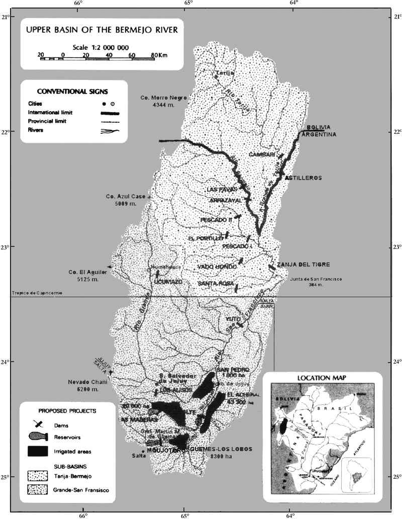
The Bermejo River begins in the Andes Mountains of north-wetern Argentina and southern Bolivia where the headwaters from two distinct river subsystems - the Tarija-Bermejo, coming from Bolivia in the north and the Grande-San Francisco, coming from the west. These two subsystems form the upper "basin" and join at the Junta de San Francisco, where the Bermejo River leaves the pre-Andean zone flowing in an east-southeast direction, 1,700 km across the alluvial plain of the Argentine Chaco to the Paraguay River (Figure 6). The upper section contains an area of 50,550 km2 while the lower section covers 43,800 km2, giving the basin a total area of 94,350 km2.
The Bermejo River drainage system, between 21° and 25° S lat., is sufficiently distant from the equator to have a strongly seasonal temperature and precipitation. Because of the highly broken topography of the upper basin, precipitation varies from 200 mm in the Quebrada de Humahuaca at the far western edge of the basin to 1,400 mm at the Junta de San Francisco. Minimum extreme temperatures vary from 13°C down to 0°C and extreme maxima vary from 34°C to 45°C, the lower temperatures occurring in the west and the higher temperatures in the east. Precipitation in the lower basin varies from 1,200 mm annually in the far eastern portion, 500 mm in the mid portion, to 900 mm at the division between the upper and lower basins. Extreme low temperatures of -8°C occur in the southwest lower basin while highs of 40°C have been measured in the east.
Figure 6. Upper Basin of the Bermejo River
High mountains, deep valleys, and pre-Andean foothills separated by wide valleys, alluvial plains, and shallow rivers characterize the upper basin. These rivers carry water only during the season of heaviest rains and are dry or nearly dry during the remainder of the year. Extreme topography and scarce vegetation contribute to high rates of erosion which are further accentuated by human influence through forest exploitation and heavy livestock use. As a consequence, many of the rivers and streams of the basin carry enormous sediment loads (estimated at 95 x 106 tons/year) from the upper to the lower portion of the river basin. As the river enters the lower basin, most of the coarser, heavier load is lost to form a broad alluvial fan. The finer, suspended matter is transported by repeated sedimentation and erosion through the lower basin to the Paraguay and Paraná rivers where evidence suggests that it is at least partially responsible for the sediments deposited in the latter's navigation channels. Other tributaries of the Bermejo River have beds of sand and finer material and are fed by groundwater flowing through the alluvial valley soils.
The lower basin is distinct from the upper basin. Here the river moves across the vast, gently sloping Chaco plain which, in recent geological time, has been filled, and locally continues to be filled, with large amounts of alluvia brought down from and the Andes. At the point where the Bermejo River leaves the Cordillera, its elevation is 280 m above sea level; at its confluence with the Paraguay River it is only 41 m above sea level giving a gradient of 239 meters over a distance of 1,188 km, only 20.1 cm/km.
In the lower basin two distinct sections can be described: an alluvial cone formed at the foot of the pre-Andean range where the river splits into many arms in a bed of up to 3,000 m width; and a lower portion where the river narrows and continues in the form of innumerable meanders. Downstream from this change in morphology, there is a tremendous network of abandoned channels, esteros, oxbows, bogs, and marshes in varying degrees of density to the confluence of the Paraguay River. These more or less stagnant, lateral water bodies temporarily connect with the main river during flood stages.
Variations in topography, elevation, precipitation, soils, temperature, susceptibility to flooding, erosion, and sedimentation, as well as the influence of man and animals, have created a number of fairly easily defined vegetation units. These include a complex mountain forest in areas of high precipitation (1,300 mm/year); a Chaco forest occurring as semiarid, transition, and humid forms, and a transition forest situated between the mountain and Chaco forests. Grasslands in the basin may be divided into three types: eastern wetlands, high elevation grasslands, and a pyric form held at a lower successional stage because of fire.
Areas that remain more or less undisturbed contain a large and diversified fauna; of the 243 species listed in Argentina, over 60 percent occur in the Bermejo River Basin. These include five species of cat, two species of fox, tapir, at least two and perhaps three species of pecari (one of which is a recent scientific discovery), vizcacha, chinchilla, nutria, capybara, anteaters, and sloths; two species of toucans, nandu, seven species of tinamou, and a large variety of water birds; two species of caiman; several species of snakes, lizards, and turtles; and a large variety of fish, many of which migrate upstream to spawn. Several species are of local importance for sport, subsistence, and commerce in skins and live animals.
The upper section of the basin contains the most active economic zones of the provinces of Salta and Jujuy. Per capita gross national product in the area is approximately one-half the national average of U.S. $1,900 in 1974. However, the annual rate of growth of the regional product was 5.2 percent in the 1960's and early 1970's compared to 3.7 percent for the rest of Argentina.
During the last 15 years the regional economic structure has been modified considerably; agriculture decreased and the industrial sector increased in importance. As a result, participation of the industrial sector in the regional product has neared 40 percent which is similar to the national average.
The economic center of the region is Salta, San Salvador de Jujuy, San Pedro de Jujuy, and Gral. Martin M. de Güimes, where the development pole for northern Argentina is situated. This area constitutes a center of attraction for both internal and foreign migration, causing a population growth rate in the 1960's of 2.4 percent compared to a national average of 1.5 percent.
In 1970, the basin's population was 789,000, 81 percent of which lived in Argentina. Of those in Argentina, 63 percent lived in urban centers. Only 33 percent of the Bolivian population was urban-based.
Investigations in the basin were wide ranging and included 26 projects, many of which had been proposed previously. Eleven of these were discarded early, although two dams built during the time of the study (Zanja del Tigre and Las Maderas) were added to the study. Because it was impossible to discuss each project, only a portion of the overall development plan was evaluated for environmental impact. Specifically, the areas of analysis chosen included an area of about 130 km2 surrounding the "Angosto de Mojotoro" and the area known as "El Acheral" containing approximately 500 km2. Both are located in the upper basin (Figure 6).
Proposals for the development of these areas called for construction of one dam on the Mojotoro River, approximately 14 kms northeast of the city of Salta, and a second dam, Vilte, to be located 120 kms downstream from Mojotoro. In addition, a small control dam was to be built 4 kms below Mojotoro to provide municipal and industrial water to increase the security of the irrigation water supply to 8,300 hectares in the Guemas-Los Cobos area. Both large structures were to help control sedimentation and cut dredging costs downstream, and Mojotoro was to further provide hydroelectric energy for the nearby industrial area and irrigation water for 18,600 hectares of newly opened land. In addition, 24,700 hectares at El Acheral were to be irrigated through pumping from the controlled flow of the Lavayén. Specific data on the two projects are given in Table 2.
Table 2. Summary data on the Mojotoro and Vilte projects of the Bermejo River Basin in Argentina
|
|
PROJECT |
||
|
Mojotoro |
Vilte |
||
|
River1 |
Mojotoro |
Lavayén |
|
|
Size of Structure |
|||
|
|
Height |
115 m |
26 m |
|
|
Width |
385.5 m |
853.0 m |
|
Storage capacity |
629 hm3 |
63 hm3 |
|
|
Reservoir size |
15.4 km2 |
- |
|
|
Reservoir life |
50 years |
27 years |
|
|
Cost US $000 |
73,330 |
13,670 |
|
|
Benefits US $000 |
101,510 |
31,490 |
|
|
Generation of electricity US $000 |
23,980 |
- |
|
|
Irrigation US $000 |
29,630 |
16,300 |
|
|
Control of sediments US $000 |
31,600 |
- |
|
|
Pot/ind. water supply US $000 |
1.38 |
2.30 |
|
|
B/C |
|
|
|
1 The Mojotoro River becomes the Lavayén River 4 km upstream from the proposed Vilte Dam.
Anticipated impacts from the implementation of the case study projects can be divided into three categories: 1) those in the area of the reservoirs, 2) those resulting from the placement of structures across the stream, and 3) those downstream from the structures. These impacts are shown in the flow chart, Figure 7. Rather than analyze each one individually, only those having, or leading to, direct economic or social impacts will be discussed. These are the impacts relating to agricultural production, power generation, health conditions, fisheries, domestic and industrial water supply, downstream fluviomorphology, population and infrastructure relocation, and recreation. In addition, preservation, as an alternative to some portions of the development projects, is discussed in economic terms.
· Agriculture
Impacts on agriculture downstream from the structures will, in the short- and medium-term, have positive economic effects in the El Acheral-Guemes/Los Cobos areas where a fairly high agriculture production already exists. El Acheral, however, is sparsely populated and has a limited amount of dry and seasonally irrigated agriculture since much of the area is characterized by a high water table, saline soils, and extensive Chaco forest. In both areas, the availability of irrigation water will increase potential productivity. Nevertheless, a number of secondary impacts can be expected to influence agricultural productivity and methods, as well as some aspects of human welfare. These will be particularly severe at El Acheral.
Irrigated agriculture often implies intensified use of herbicides, pesticides, fertilizers, and machinery with larger and fewer farms. Irrigation waters discharged into the Mojotoro and Lavayén rivers can be expected to increase the level of contamination which, in turn, could disrupt aquatic habitats and introduce pesticides into the food chain.
Under the assumptions of the original study, agricultural benefits were estimated at $44,820,000. However, because of prevailing conditions in the area, irrigated agriculture in El Acheral may encounter significant salinization problems and these will either reduce the area's long run agricultural productivity or involve increased management and capital costs to maintain expected productivity levels. Therefore, either productivity losses over time must be estimated or, if losses are assumed to be greater than prevention costs, these costs must be included in determining agricultural rents.
The discharged irrigation water from the Guemes/Los Cobos area has a higher nutrient level and would contribute to increased rates of evapotranspiration in the Vilte Reservoir because of greater waterweed growth. Utilization of this water could aggravate the salination problem in El Acheral also and an increased evapotranspiration would reduce the reservoir water supply estimated as being available to irrigate the 43,000 hectares in El Acheral. If this is true, then the estimates of irrigable hectares would have to be reduced and benefit estimates adjusted downwards. Further complications may arise due to a significant loss of water required to maintain natural ecosystems further downstream.
Figure 7. Qualitative environmental impacts due to dams and reservoirs
· Power generation
Total power benefits of the Mojotoro Dam, in terms of the costs for the next best alternative of power, were estimated at $23,980. However, there is some indication that waterweed growth in Mojotoro Reservoir will contribute to increases in evapotranspiration rates and water losses from the reservoir. To the extent that further research identifies a significant reduction in the available head for power benefits, these would have to be adjusted downwards or weed management costs included in the project's operating costs.
· Human health
A number of factors have been identified as contributing to increased human health risks as a result of the projects. Initially, the stillwater environment of the Mojotoro and Vilte reservoirs and the associated irrigation canals will create prime disease vector habitat. Expansion of the malaria-bearing mosquito population is seen to be highly likely and this expansion, coupled with regional immigration, is expected to increase the incidence of malaria in the area. Regional immigration may bring in other vectors and parasitic hosts as well. Schistosomiasis is one of these latent dangers since aquatic weeds create adequate living conditions for the alternate host snail. Although the disease is not yet present in the region, the snail is endemic to the Plate River Basin of which the Bermejo is a part and immigration of infected human beings may help establish the disease in the upper basin.
The economic effects of the increased health risks created by the reservoirs and irrigation works may be calculated in two ways, although neither is completely satisfactory. The first is to estimate both the probable incidence of disease associated with the projects and the average per capita loss in productivity as a result of infectation. To this would be added a figure for average treatment costs per individual in order to reach a total health hazard cost. The problems with this approach are its difficulty of application and its incomplete assessment of human suffering. An evaluation of the probable incidence of disease is a demanding task for the medical statistician, but possibly fraught with no greater uncertainty than many other estimates called for in complex project evaluation.
A second method commonly used is to estimate the costs of vector control programs. Though a simpler approach, it carries the implicit assumption that the project cost is less than any social costs associated with the disease. Public health and data availability will provide the guidelines upon which a choice of approach can be made.
It is obvious that the above procedures do not attempt to account for the negative impacts to the ecosystem and human health, including suffering and loss of life brought on by the use of pesticides.
· Fisheries
Many facets of the proposed Mojotoro/Vilte projects could prove deleterious to the aquatic ecosystems of the Mojotoro and Lavayén rivers. For example, the structures represent barriers to the movements of migratory riverine species and, interruptions in their life cycles as well as contamination of their food chain, could prove lethal. Alterations in river hydrology could affect spawning grounds, water temperatures, and food supplies. Irrigated agriculture, a major component of the projects, can significantly affect existing fish populations by the discharge of irrigation waters high in organic matter and chemical contaminants. It is most probable, therefore, that existing fish populations will be negatively affected by the proposed projects.
However, the existing fisheries of the Mojotoro and Lavayén rivers are evidently not extensive and fishing activity is minimal. The major economically important species in the Bermejo system include sabalo, surubi, pacu, armado, and dorado and, although many of these species appear in the Mojotoro/Lavayén area, accurate estimates of population and catch are not available. It is not possible, therefore, to develop specific estimates of the value of the existing fisheries until longer range and more intense investigations are initiated.
The creation of still water reservoirs sometimes has the potential to compensate for loss of natural river fishery. Although reservoir fisheries will usually constitute a different species mix than the natural fisheries, they can prove to be of equal or greater value if provision is made before the reservoir is filled.
For a complex set of reasons, the reservoir should experience high initial fish production due to the rapid release of nutrients from decomposition of inundated vegetation. However, as the rate of decomposition and nutrient release declines, as aquatic vegetation begins to extract available nutrients, and as the reservoir becomes eutrophic, a decline in fish production may occur. Water vegetation and any debris remaining in the water will severely hamper both recreational and fishery activities.
The reservoir fishery potential of both the Mojotoro and Vilte reservoirs is not expected to be large. Since the Vilte Reservoir will be shallow and undoubtedly high in organic matter, it will experience relatively rapid rates of evapotranspiration and eutrophication. The Mojotoro Reservoir appears to have a greater fishery potential than does Vilte, since contamination, weed infestation, and increased rates of evapotranspiration and eutrophication are not expected. Research on the probable characteristics of the proposed reservoir and the adaptive capacities of existing riverine species or on any potential exotic species that could be used to stock the reservoir remains to be done.
Given adequate information, the effects of the proposed projects on the fishery could be evaluated in terms of the net value of commercial production and on the value of the fishery for subsistence food supply and for sport fishing.
The approach would be to determine the current and future potential value of the fishery for each of the above purposes without the effect of the project. Then, having identified the changes in fish production and catch as a result of the project, the value of the fishery should be estimated with the project. The difference between the two results would constitute one component of the fishery costs or benefits associated with the project. To this one should add the value of the reservoir fishery, net of management costs, created by the project to reflect the impact of the proposed project on the fishing sector.
· Fluviomorphology
Mojotoro and Vilte dams are to serve as barriers to sediment movement downriver. Containment of fine sediments (between 5 and 20 microns) would reduce their deposition in the lower reaches of the Paraguay, Paraná, and Plata rivers. This would somewhat alleviate the dredging costs required for maintaining navigation channels. However, removal of a river's sediment load often tends to increase the cutting action of downstream flows. Although the complexity of the Bermejo drainage system and the scarcity of data do not allow exact quantitative predictions to be made of the fluviomorphic impacts, preliminary conclusions suggest that nothing detrimental of any magnitude should be expected as far downstream as Guemes (50 km from Mojotoro). Below Guemes, a period of bank erosion and some stream bed degradation should occur and there will be marked instability during floods from tributaries entering the main stream between Mojotoro and Vilte. This could be a problem for some agriculture, infrastructure, and wildlands in the area.
The dam at Vilte would push this potential erosion problem further downstream, below the confluence of the Lavayén and Rio Grande (80 kms from Vilte) where the future behavior of the river becomes even more uncertain. For example, the possible effects on the islands in the Paraguay and Paraná rivers and possible bank erosion all along the Bermejo River have not been adequately evaluated. Furthermore, with stream regulation and falling discharges, some reaches may not scour adequately and, since river transport is dependent on minimum depth, short stretches of the channel may require dredging. Thus, sedimentation benefits may need to be adjusted downwards.
· Domestic and industrial water supply
The Mojotoro Dam was to provide a source of water for domestic and industrial purposes. Benefits of providing this water can be measured by either the customer's willingness to pay for water from this source or by adapting the cost of the next best alternative source. Domestic water supply benefits were not estimated in the original study because this market is given exclusive priority use in Argentina; industrial benefits were estimated at $31,000,000 for Mojotoro.
However, the expected rapid rates of evapotranspiration in the Mojotoro Reservoir require evaluation of their implications on the volume of water available for domestic and industrial purposes. To the extent that evapotranspiration would occur, the supply for the competing uses (power, industry, and irrigation) would be reduced and this would imply lower industrial user benefits than those originally estimated. In addition, surface and groundwater contamination due to salinization or pesticides imposes incremental costs in the provision of acceptable domestic water supplies over those that normally prevail. These costs should be charged to the agriculture projects.
· Relocation of population and infrastructure
Beginning with the main structure at Mojotoro, construction will require relocation of the principal Salta railway line. Only a very small number of residents in the village of Mojotoro will need to be relocated as a result of construction of the Mojotoro and Vilte reserviors. Still, their situation is real and is representative of the problems of relocation occasioned by development.
Three types of possible costs are suggested by the situation of the residents at Mojotoro: a) loss of property values, b) relocation costs, and c) distress costs.
Construction of the dam will reduce residential property values in Mojotoro to zero, thus the current market value of land and buildings in Mojotoro should be included as a cost of the dam. In addition, forced relocation will require incremental out-of-pocket costs which are also legitimate costs of the dam. Psychic distress is often caused by forced relocation since it alters life styles, or, as a result of forces beyond their control, requires residents to give up an environment to which they had become attached.
· Recreation
Outdoor recreation is a legitimate competitor both for the direct services of water and land resources, and for the indirect services through the fish and wildlife that inhabit them. Although the proposed reservoir at Mojotoro should have a recreational potential, no actual benefits were estimated for this resource use. Neither was any mention made of the recreation or other use potential foreclosed by execution of the proposed projects.
Since outdoor recreation services are usually provided on public lands, market determined prices are seldom available. Consequently the value of outdoor recreation resources is generally measured by the willingness of individuals to pay for the services of the resource (Davis, 1963). In addition, where regional objectives are relevant, expenditures of tourists visiting the resource (i.e. food, lodging, transportation, etc.) can reflect the income and employment value of the resource to the region (Clawson and Knetsch, 1963; Knetsch, 1974).
The willingness to pay for a commodity can be approximated since the value of the commodity is a function both of the quantity of users and the price they would be willing to pay. In recreation evaluations, the commodity is a defineable area having specific recreational amenities; the objective is to determine the value of these amenities rather than the value of outdoor recreation in the general sense. Just what the beneficial and adverse impacts of the proposed projects would be on recreation cannot be adequately presented because of a lack of data.
Despite the fact that the areas of Mojotoro and El Acheral are considered to have rather commonplace amenities and the landscape, flora, and fauna are fairly common to many other areas in the general region, the costs and benefits of the projects relevant to the recreation potential should be analyzed. Of course impacts associated with the amenity services cannot be specifically valued although they can be evaluated within a framework which permits their comparison to more easily estimated economic costs and benefits.
The methodology for doing this is laid out in the next section which attempts to evaluate the loss of any of the attributes of the natural system because of execution of the case study projects.
· Preservation of natural system services
Calculating a value for preservation is an attempt to place a value on the amenity services provided by an area which would be foregone if development were to take place (Knetsch and Fleming, 1975). Amenity services, as stated earlier, are those services that cannot be valued because of the lack of a market mechanism. They consist of services provided by natural ecosystems which may not even be known nor understood but which have a life support function (ecosystem stability/diversity, primary production, hazard reduction, nutrient cycling, contamination abatement) as well as such things as the value of the natural gene pool, recreation potential, and other natural system services and the preservation of unknown future options. Calculation of a value for these services depends on the discount rate, rates of shift in price and quantity intercepts, and years to capacity constraint. This value is then compared to the potential benefits accruing with development.
For example, the net economic benefits of the case study to which environmental values would be compared is the estimate of $46.0 million. Against this assumed level of net economic gain, the value of the area were it to be preserved must be compared. Only if it can be demonstrated that the economic benefits clearly exceed the amenities foregone, should the project be sanctioned.
Rather than attempting to determine the actual value of the preserved amenities, the question to pursue is how large the environmental preservation benefits would have to be to equal the net economic development benefits. Or, to shift the "burden of proof," the question could be put in terms of what assumptions and assertions are necessary to support the presumed superiority of the development values over those of preservation. Generation of the evidence needed to make this judgement requires examination of the demand characteristics for the environment under study. The foci of this examination are the immediate demands and how they might change over time.
Ample evidence exists in many parts of the world to prove that the general demand for the amenities of natural ecosystems is growing at a very rapid rate. The same type of growth is not readily apparent in Argentina, although some of the prerequisites to developing interest in these amenities are beginning to surface. Preservation values in the case study area are modest at present, but these might be expected to grow over the long-term as expansion of Salta, Guemes, and La Caldera put pressure on nearby areas. In contrast, the benefits of power and agricultural outputs will be greater in the short-term if development takes place.
Whatever the level of initial preservation benefits, they would be represented by the willingness to pay for the environmental resource amenities. If demand for these services increases over time, this would indicate an increase in value. Generally speaking, this demand grows with increased population and income and changing needs and tastes, although growth in demand for a specific site is dependent on additional factors - increases in the amount of use for individual recreation areas or use of a river for pollution dilution purposes are examples. These and other natural amenities are subject to congestion or saturation restraints. For example, in the case study area, the alternative assumptions of growth in quantity demand are set relatively low (3%, 7%, and 10%) while the discount rate assumptions (10%, 15%, and 20%) are relatively high (Table 3).
The price people would be willing to pay for the services of a very unique area would be expected to increase more rapidly than real per capita incomes. On the other hand, if the services of the area are common and numerous areas with similar services are available, then a high degree of substitutability in the natural amenities can be expected and the price that people would be willing to pay for the services of these areas would not increase at a rate faster than the growth in per capita incomes. This is assumed to be the case for the Mojotoro and Vilte areas.
The historical growth in per capita income in the case study area has been about 1.0 percent annually; projections of the original study, however, assume a growth rate of about 4.0 percent annually. For our purposes, the assumed range of growth in the price intercept of the demand schedule is 1 percent, 3 percent, and 6 percent, and the implications of these alternatives are summarized in Table 3. Initially, the willingness-to-pay figure is assumed to equal $1. Subsequent shifts over time, based on the site specific implications of income and population growth, enlarge this value. Willingness to pay each year is taken to be the value of the benefits derived that year from the area's amenities, and the present value of the benefits derived that year from the area's amenities, and the present value of the benefit stream is obtained by discounting the annual benefits at the appropriate rate.
Assuming the discounted growth benefit for preservation of the area are: quantity growth, 3.0 percent; price growth, 1.0 percent; and discount rate, 15.0 percent; the present value of the annual benefits would be $7.90. This figure can then be divided into development losses (the estimated net economic benefit that would accrue if the Mojotoro and Vilte sites were developed for the projects under study) to establish the value required for the initial year's preservation benefits in order for the site's preservation to be economically justified. Under the above benefit assumptions, and assuming the figure for net economic benefits ($46.0 million), the areas would require an initial year value of $5.8 million to justify preservation.
Although the preservation of the natural amenities of the case study area can probably not be justified on the basis of this value, the numerous impacts discussed above may reduce total benefits. This and the unknown value of many other environmental aspects seem to justify further investigation of the proposed reservoirs and the characteristics of the natural ecosystems which will be destroyed if the real costs of this development are to be estimated.
Table 3. Present value of one dollar of natural area preservation benefits growing over time and discounted to initial year
|
Benefits Growing Over Time and Discounted to Initial Year |
|||||
|
Initial rate of shift in quantity intercept |
Years to capacity constraint |
Rate of shift in price intercept |
Present value of $1 at discount rate1 |
||
|
(%) |
(%) |
10% |
15% |
20% |
|
|
3
|
50
|
1 |
17.06 |
7.90 |
6.51 |
|
3 |
25.17 |
11.99 |
7.62 |
||
|
6 |
60.24 |
18.69 |
10.07 |
||
|
7
|
30
|
1 |
29.89 |
14.50 |
8.91 |
|
3 |
46.99 |
19.37 |
10.87 |
||
|
6 |
118.26 |
33.32 |
15.51 |
||
|
10
|
20
|
1 |
36.42 |
18.15 |
10.99 |
|
3 |
55.16 |
24.12 |
13.55 |
||
|
6 |
126.59 |
40.19 |
19.42 |
||
1 Present value factors estimated using Ciccetti formulation but with different equations and a constant decay factor by Knetsch and Fleming, 1975.
![]()
![]()
![]()
![]()