![]()
![]()
![]()
![]()
The purpose of this section is to apply the planning methodology developed by the Pilot Study to that used in the original upper basin investigation in order to see whether there are specific differences and what they are, and whether or not these differences would have changed the final result.
A critique will be made at the levels of the overall objectives of the original agreement; the reconnaissance and area surveys; regional diagnosis; development of action guidelines, priorities, and project selection criteria, identification, evaluation, and selection; suggestions for administrative structures; and scopes of work and research needed for the feasibility studies (Figure 8).
· Formal Accord for a Water Resources Investigation in the Upper Basin of the Bermejo River
The "Technical Assistance Accord for the Study and Development of the Water Resources of the Upper Bermejo River Basin" established the objectives, plans of operations, and specific terms of reference for the planning investigations (OAS, 1970).
Overall objectives, as given in the Accord were:
a) To undertake a reconnaissance of the water resources of the upper basin in order to identify specific development projects;b) To evaluate these projects and make general recommendations on the sequence and time frame of their execution;
c) To develop the terms of reference for future studies of investment projects that could be submitted to international financing agencies; and
d) To supply the technical basis for making decisions on the integrated development of the water resources of the upper basin.
The Accord clarifies some environmental issues. Specifically it shows a regard for coordinating plans within the region and makes explicit a concern for the disposition of water contaminants; it attempts to deal with the potential sanitary problems related to the water resource and to establish water quality benchmarks. Further, it concerns itself with the question of recreation and an interpretation could be made for a requirement to establish a demand for pollution dilution of the water resource. Erosion control projects are mentioned, although not necessarily as alternatives to the use of reservoirs to control sediments.
A major consideration of the Pilot Study methodology is to include an environmental quality objective as one of the overall objectives of a planning investigation. This was not done in the original upper basin study - in part, because traditional river basin planning objectives seldom include environmental quality as a specific concern and, in part, because the study was initiated prior to significant worldwide concern for environmental protection. One could have been included, however, because the Government of Argentina does have laws and official policies to deal with environmental protection. For example, the National Plan for 1971-1975 includes objectives in the Agriculture, Water Resources, Public Health, and Tourism sections which emphasize environmental quality (GOA, 1971).
In addition, Decree No. 558 of August 7, 1970 (GOA, 1970) contains specific policies to:
- "Promote the conservation, investigation, and diffusion of the nation's cultural heritage..." (paragraph 19).- "Prevent air, water, and soil contamination; to establish severe norms and assure their strict enforcement" (paragraph 41).
- "Assure the preservation and promote the understanding of the natural landscapes of the country, its flora, and its fauna, especially through creation of the necessary national parks and reserves as well as through adequate conservation of those already existing" (paragraph 94).
The Accord describes seven major components to be investigated during the reconnaissance and prefeasibility activities: 1) analysis of the present situation, 2) determination of the availability of water resource, 3) determination of water needs in terms of quality and quantity, 4) studies on erosion and sedimentation processes in the upper basin, 5) formulation of preprojects, 6) an analysis and evaluation of preprojects and programs, and 7) recommendations on criteria, policies, and legislation, project priorities, and feasibility studies.
Also, despite the fact that the Accord goes beyond the normal interest in the environment on the part of planning at this stage, the new methodology would have greatly clarified some aspects of this concern. For example, the Accord requires an "analysis of tendencies in ... use of water for irrigation, potable, and industrial water, navigation, generation of energy, etc." The new methodology would have made explicit what is incorporated in "etc.," since the Accord may have meant to include environmental concerns, such as pollution dilution, recreation, and terrestrial and aquatic ecosystem maintenance.
There are some statements in the Accord that would tend to restrict the planner in the development of project alternatives. For example, it indicates that flood control and drainage projects would automatically have a positive impact when, in fact, not all flooding is negative nor all drainage positive. This is indeed the case in the lower basin where flooding plays a major role in ecosystem stability. Similarly, the Accord specifically asks for a regional economic evaluation of the projects but says nothing about an environmental evaluation.
· Reconnaissance survey
The reconnaissance survey consisted of two man-months of work undertaken by a specialist in water resources. Terms of reference required a review of existing information pertaining to the development of water resources of the area; contact with local agencies to better define the purpose and future activities regarding the project; preparation of a report on existing conditions and use of water in the Bermejo Watershed; and assistance to the Mission Chief in the preparation of the study's work plan.
Environmental concerns were not explicitly considered during the reconnaissance survey. In fact, the terms of reference included only a mandate to look at the water resource. Data relevant to categories of the environment, particularly fisheries biology and agriculture, were evidently not reviewed and emphasis was given only to the immediate study area. Significant areas downstream from the study area would have received a more thorough coverage under the new methodology. Furthermore, a number of colleges, universities, and museums as well as individual scientists and research entities having substantial knowledge of environmental material within the basin were not consulted.
· Area survey
From the report of the reconnaissance survey, a work plan was developed for the remainder of the investigation, including objectives, terms of reference for an area survey, and the identification and evaluation of projects. Initial studies considered natural resources (with emphasis on hydrology) and the socio-economic structure of the basin; special studies and analyses were made in preselected disciplinary and geographical areas as well as on existing projects and project ideas.
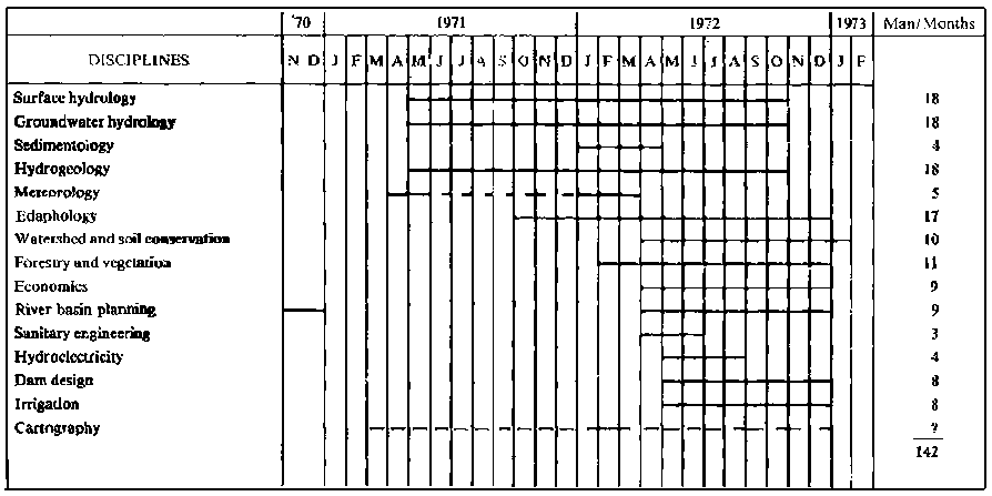
As indicated in Figure 9, 15 different disciplines were used in the investigation for a total of at least 142 man months of work. During the area survey, an analysis of the actual situation of the upper basin of the Bermejo River identified problems affecting resource development, determined the availability of the water resource and its relationship to both present and future demand, and defined the trends of various water uses, to help orient their development. Existing information on cartography, surface and groundwater hydrology, geology and geotectonics, meteorology, general ecology, edaphaology, and the population and economic structure were evaluated. Inventories and evaluations of natural resources were made, including local and regional availability, quantity of and demand for surface and ground-water. Likewise, actual resource utilization in the upper basin was evaluated and an analysis of use trends in irrigation, domestic and industrial water consumption, and electric power generation was made. Studies on groundwater distribution, land use, agricultural productivity, land tenure, population structure, water rights, and concessions were made. An analysis of existing criteria, plans, programs, and projects related to development of watershed resources was also undertaken.
Figure 9. Work plan for the Upper Basin of the Bermejo River Water Resources Planning Investigation
Studies of problems affecting development were made in areas affected by flooding, erosion, drainage, and salinization problems; a study of subterranean waters focused on the valleys of the San Francisco River Watershed. Geological studies in the basin focused on the potential locations of dams and other important water works as well as on locating materials for use in future construction. Additionally, the general characteristics of the underlying stratum in areas to be irrigated and in those which may have subterranean waters were investigated as were areas having a high risk of erosion.
Surveys of the soil and vegetation resources consisted of a general analysis of photomosaics at available scales and compilation of information on maps with a scale of 1: 250,000 (soil units, natural pastures, vegetation, erosion areas, types of erosion, present land utilization); identification of areas with high use potential especially for irrigation; and identification of areas where there are problems of salinization, alkalinity, and drainage. Economic studies were carried out to provide guidance for decisions on the use of limited financial resources.
A substantial part of the planning studies focused on the analysis, formulation, and selection of alternative projects for the utilization of the water resource. Analyses of the market conditions were made emphasizing those conditions affecting irrigation requirements, electric power demand, and the relative benefits of flood, erosion, and siltation control facilities. The actual situation of agricultural and its potential development accounted for a substantial portion of the analyses although the actual situation and targets established for forestry, industry, and mining were studied with a view to planning for integrated regional development. Efforts were concentrated on comparative regional advantages and disadvantages, as well as on prospects for exporting surplus production. The work plan developed on the basis of the reconnaissance survey and the Accord was in line with both of these documents.
Many of the potential environmental problems mentioned in chapter five could have been avoided by using the methodology considered in chapters two and three, such as specific instructions and opportunities for interaction among the experts, an accounting of the concepts involved in "ecology," explicit environmental concern, a technical team that included environmentally-oriented experts, and explicit environmental quality terms of reference for use by other technical experts. Similarly, there is no indication that public concern was taken into account, nor was there a mandate to review downstream demands for the water resources or to analyse the potential effects of a possible reduction of total and seasonal water supply to downstream areas.
Experts who could have evaluated most of the potential environmental problems through the generation and evaluation of more data are indicated in Figure 10. If these were only to be "add ons" to the original study, this would have amounted to somewhat less than 15 percent of the total man/months utilized by the original technical group. Or, if adjustments were made in the overall work plan (including environmental quality terms of reference for each specialist), the work of environmental protection could have been undertaken at no extra cost (Figure 10). The fact that these subject areas were not included stems primarily from lack of an explicit environmental objective and lack of an environmentalist being incorporated as a member of the reconnaissance survey team. Had either or both of these been utilized, it is probable that most of the environmental problems would have been adequately covered during the study.
Of major importance is the use of a limnologist or fisheries biologist in any planning effort that proposes substantial changes in the hydrologic regime of a major river basin. This, perhaps, is the major shortcoming of the upper basin study; it did not adequately consider potential environmental damage to the aquatic ecosystem. The water resource is too important, both in its role in primary production and in its role as the natural communication link from the upstream watershed to the sea, to be inadequately studied.
As has been suggested, the original plans for the hydrologic development of the upper basin could possibly cause severe damage to several important fish species by making seasonal migration impossible and by disrupting their spawning cycles. Furthermore, the stream regulation envisioned in the plan could substantially reduce the primary production of the downstream wetlands and, as a consequence, eliminate important species from the drainage system by reducing food supply at critical stages of their life cycle. Specifically overlooked is a law obligating the installation of fish ladders on any dam under national jurisdiction (GOA, 1933). This oversight would not have happened had a limnologist or a fisheries biologist been included in the technical team and had there been opportunity for substantive interaction between this expert and those who designed the structures.
Similarly, use of an epidemiologist is of paramount importance where increased disease incidence is a possibility, as is the case in the majority of developing countries. The Accord specifically asks for an analysis of sanitary problems related to the water resource but does not explicitly discuss the need for epidemeological studies in planning water resource use in the upper basin; the work plan itself does not mention, nor did the study treat, health problems. An environmentalist on the reconnaissance team probably would have assured the treatment of health problems related to water development. Close cooperation between an epidemeologist and a sociologist/anthropologist would have allowed the evaluation of the consequences of both on-going and increased migration in terms of potential health problems and increased health service and disease control measures.
The use of an ecologist was not considered, although the work plan mentioned general ecology. Thus the dynamics of the basin ecosystems were not considered, and little thought was given to describing critical aspects of subsystems either in the upper basin or downstream through the Bermejo, Paraguay, Paraná, and Plata river systems. If an ecologist with the help of a systems analyst had been utilized early in the natural resources survey to define the life zones in the project sites and other critical areas downstream in order to construct a prefeasibility stage conceptual model of these life zones (ecosystems), the major areas and processes could have been identified and described.
The Accord mentions an evaluation of recreational resources and demand, but this aspect did not appear to be treated in the resource evaluation nor were potential recreational projects evaluated. Several areas of the upper basin as well as the future reservoirs themselves offer recreation and tourist potential. Although, at this time, demand for these resources is quite low, they can become quickly overloaded if their use is not planned.
Changes in the terms of reference for those disciplines that were utilized could have been made. The sanitary engineer, for example, should have spent some time on an evaluation of the capacity of the basin's water resources for self-renewal in terms of industrial, urban, and agricultural contamination. This aspect of a water resource is a service of the natural system that can profitably be used, but easily overused if not adequately planned. Someone specializing in wild land management rather than watershed management would have undertaken tasks similar to those of the watershed management specialist but would have had a broader view - something needed at the early planning stages. The objectives assigned to the forester and plant ecologist could have been accomplished in much less time at this level of planning and their work could have been used more profitably by the rest of the planning team.
· Regional diagnosis and guidelines for development action
A regional diagnosis was made of: 1) the use potential of the upper basin's water resource, 2) the positive and negative factors for development, and 3) the water resource demands. From the results of this diagnosis, a preliminary global water balance was developed for the upper basin and the three subareas: Quebrada de Humahuaca, Development Pole, and El Ramal. No evaluation was made of the water demand to maintain the services of the natural systems in the upper basin or downstream.
The regional diagnosis was followed by a general characterization of the potential for hydroelectric energy production and available volumes for irrigation of the major upper basin river systems. The underground water resource, particularly in the San Francisco area, and its present and potential use were also investigated. Concurrently, a general analysis was made of the soil resource to locate potential agriculture areas and to locate areas now under cultivation which could have improved production if irrigated.
At the same time, guidelines for development action were given to the planning mission by the Government. These required resolution of the energy deficit in the region; industrialization of the mining sector; development of additional industry; and increased agricultural productivity.
Except for control of erosion, sedimentation, and flooding, there was virtually no mention of environmental concerns in the regional diagnosis and guidelines sections of the upper basin planning methodology. Whether or not these would be environmentally sound would depend on the potential impact downstream of the projects themselves and these may, indeed, be negative. Consideration of the temporal and total demands made on the water resource; first, by the services offered by the natural system and; second, for maintenance of the natural ecosystem could have avoided these problems. The guidelines for development action did not consider environmental protection, environmental planning, or the generation of alternatives.
· Definition of objectives and priorities; establishment of selection criteria; identification of projects; and economic analysis of local and regional demand
The Government defined the objectives and priorities in the hydroelectric energy, irrigation, and industrial and municipal water supply areas as well as in the control of erosion, sedimentation, and flooding, and established the criteria for the selection of projects. These criteria dealt with the resolution of the energy shortage, further development of the region, more complete use of the agriculture and livestock potential in addition to providing opportunities for training and for greater, more equitable, income distribution.
Identification and formulation of specific projects followed a global evaluation of the water resource, including the identification and predesign of water projects, irrigation schemes, groundwater exploitation, and an economic analysis of regional and local demand for hydrologic resources for energy, irrigation, industrial, and domestic purposes. Again, no mention was made of the potential utilization of natural systems services for such things as flood control and waste disposal; nor was environmental protection mentioned as an objective or a priority. The selection criteria included nothing on environmental quality, environmental health, or environmental protection. Several potential projects, such as recreational development, fisheries, and non-structural alternatives for irrigation and control of erosion and sedimentation, were not completely identified.
· Project evaluation
Hydroelectric projects were evaluated on the basis of their ability to supply energy for the needs of the region and, secondarily, on those benefits accruing to irrigation, industrial and municipal water supply, and sediment control. Parameters used in evaluating irrigation projects were the efficiency of the project, the period of time necessary to make the project operational, and the potential agriculture production of priority crops, such as vegetables, tomatoes, citrus, alfalfa, sorghum, soybean, sugar cane, cotton, and tobacco.
National, regional, and local authorities were consulted and the preprojects made compatible with national and regional objectives. A preselection of alternative development schemes was made and individual projects evaluated. From this process the national and binational programs and projects were selected, a schedule of investments was decided upon, and an administrative structure suggested. Subsequently, scopes of work for the feasibility investigations were developed along with suggestions for a number of complementary studies.
Benefits from all projects were calculated on the basis of: potable and industrial water supply, irrigation, utilization of return water, generation of electric energy, and sediment control. Costs for these projects included only direct costs and costs of operation and maintenance. There appears to have been no consultation with the public, other than perhaps through local and regional representatives, to get its view on the value of the proposed projects. No display of other quantitative and qualitative impacts was given. Fifteen of the 26 projects evaluated are given in Table 4.
Criteria for identification, formulation, and selection of individual projects and programs for the hydrologic development of the upper basin were overwhelmingly economic, while concern for potential environmental impact had almost no influence. There was no substantive environment impact evaluation of this or alternative plans for meeting the stated objectives under the stated criteria. The display of the evaluation was inadequate in terms of environmental quality criteria although it did go somewhat beyond the use of a benefit/cost ratio. Since so little explicit concern was given to the environment, even those impacts that could be costed out monetarily were not treated.
· Administrative structure
According to the plan, each country would have a National Bermejo River Basin Commission that would have the following functions: execution of the plan, either by itself or by delegation to other public institutions or through private contracts; general coordination of national and regional development programs which would treat the renewable natural resources of the basin; administration of the plan; promotion of the basin's development; and advising the Executive Office of the nations in their work with a proposed International Commission.
The great number and diversity of local, regional, and national organizations interested in the use of the water and other resources in the basin suggest that the administrative functions necessary for the development of the upper basin should have been centralized.
· Scopes of work for the feasibility studies
The plan for development of the water resources of the Upper Bermejo River Basin outlined the scopes of work for the feasibility studies of projects proposed for the area of the growth pole. In terms of the Pilot Study, these consisted primarily of construction of dams at Mojotoro and Vilte, implementation of irrigation systems at El Acheral, and construction of the aquaduct to Guemes, and dealt with feasibility level studies in topography, hydrology, soil mechanics, and edaphology. In addition, several basic investigations were proposed to gather additional data on climatology, hydrology, geology, seismology, and demographics.
Other concerns of a feasibility nature were given as a check list:
- Socio-economic effects of the individual projects and of the projects as a group.- Potable water demand.
Table 4. Project evaluation and summary. Upper Basin of the Bermejo River Water Resources Planning Investigation
|
Benefits, Thousand of US Dollars | ||||||||
|
River |
Project |
Cost |
Generation of electricity |
Irrigation |
Sediment control |
Industrial and potable water |
Total |
Benefit/cost |
|
Tarija |
Cambari |
43,220 |
67,560 |
7,860 |
30,680 |
|
106,100 |
2.45 |
|
Tarija |
Astilleros |
148,460 |
48,760 |
10,100 |
30,680 |
|
89,540 |
0.60 |
|
Bermejo |
Las Pavas |
59,300 |
55,800 |
9,600 |
28,600 |
|
94,000 |
1.59 |
|
Bermejo |
Arrazayal |
59,840 |
76,300 |
10,200 |
28,600 |
|
115,100 |
1.92 |
|
Pescado |
Pescado II |
180,040 |
52,300 |
7,480 |
10,700 |
|
70,480 |
0.39 |
|
Iruya |
El Portillo |
54,370 |
55,950 |
3,920 |
|
|
59,870 |
1.10 |
|
Pescado |
Pescado I |
112,330 |
40,300 |
7,200 |
10,700 |
|
58,200 |
0.52 |
|
Blanco |
Vado Hondo |
194,130 |
66,410 |
7,120 |
|
|
73,530 |
0.38 |
|
Bermejo |
Z. del Tigre |
307,420 |
184,840 |
53,800 |
157,000 |
|
395,640 |
1.29 |
|
Colorado |
Santa Rosa |
18,138 |
|
20,200 |
|
|
20,200 |
1.11 |
|
Los Alisos |
Los Alisos |
14,380 |
|
4,720 |
|
530 |
5,250 |
0.36 |
|
Perico-Grande |
Las Maderas |
189,900 |
|
33,930 |
|
68,900 |
102,830 |
0.54 |
|
Mojotoro |
Mojotoro |
73,330 |
23,980 |
29,630 |
16,300 |
31,600 |
101,510 |
1.38 |
|
Levayén |
Vilte1 |
13,670 |
|
15,190 |
16,300 |
|
31,490 |
2.30 |
|
S. Francisco |
Yuto |
112,570 |
38,410 |
64,100 |
31,270 |
|
133,780 |
1.19 |
1
Based on a theoretical evaluation since the useful life of Vilte without Mojotoro is less than 30 years.
Industrial water demand, including an analysis of the situation, park siteing, and a theoretical evaluation of demand.
- Irrigation and rural planning.- Tourism and recreation (site characteristics, demand, planning).
- Stream regulation (sediment and flood control, including river characteristics, size of suspended sediments, bed load, effect of dams on sediment transport, flood control, and downstream effects resulting from control of sediments and erosion).
- Mathematical models.
- Conceptualization of hydraulic works.
- Selection of the basic projects (dams, aquaducts, power centers, bridges and roads, lateral dikes, foundation consolidation, design, construction program).
- Irrigation projects.
- Economic evaluation (social evaluation; procedures and indices; opportunity costs; sequence, period; determination of benefits of irrigation, potable and industrial water supply, sediment control, flood control; recreation and tourism; investment costs; operation and maintenance costs).
- Financial evaluation.
- Administrative organization; legal and institutional aspects.
In addition to the terms of reference of concern in the feasibility study, complimentary studies and specific recommendations to allow a better understanding of the natural environment within which the projects would be undertaken were presented. These consisted of recommendations for additional studies in cartography, meteorology, hydrology, hydrogeology, geology and soils, land conservation and use, and forest and pastures.
Of particular interest were the suggestions to make detailed studies in representative watersheds to characterize and model the hydrologic cycle in the region and to utilize smaller experimental watersheds to evaluate the effects of irrigation, deforestation, and overgrazing on the hydrologic cycle. In hydrology, studies were suggested to compute the sediment discharge; in hydrogeology, to evaluate potential groundwater contamination problems; in soils, to find methods of reclaiming saline soils; in land management and conservation, to select pilot areas for further study; and in forestry and range management, to begin control of exploitation and to locate areas requiring protection.
The outline of the scopes of work for feasibility studies was wide-ranging but did not treat environmental concern in detail. For example, further study of the problem of migration was not mentioned, and studies of potable and industrial water demand did not include water quality nor the treatment and dispersion of residuals. Problems relating to health and to the biological resources of the river system either in the area of study or downstream were not covered in the scope of work or in any of the recommended studies.
Although the recommendations did provide for studies of the effects of the plan on downstream sedimentation and flooding, as well as for studies to implement upstream erosion control measures - thereby potentially rectifying many of the environmental omissions at the reconnaissance and prefeasibility planning stages - the danger is that they will come too late in the process to bring about major changes in the plan without substantially increasing costs and, perhaps, decreasing benefits exists.
![]()
![]()
![]()
![]()