![]()
![]()
![]()
![]()
![]()
Background Paper: Management of Aquatic Ecosystems
Background Paper: The Environmental Conditions in Latin America - A Brief Overview
Sub-track: Environmental Problems and Assessment
Sub-track: Protection and Restoration Strategies
![]()
Co-Chairs
Joseph B. Browder, Partner, Dunlap & Browder, Inc., Washington, D.C., USAModeratorsDr. Emiko Kawakami de Resende, Secretary of the Environment, State of Mato Grosso do Sul, Brazil
Sub-Track: Environmental Problems and Assessment
Dr. Thomas Lodge, Principal Environmental Scientist, Law Environmental, Inc., Fort Lauderdale, Florida, USASub-Track: Protection and Restoration StrategiesMiguel Monserrat, National Director of Water Pollution Control, Water and Environment Advisor, Secretary of the Presidency, Argentina
John Kusler, Executive Director, Association of State Wetlands Manager, Berne, New York, USACoordinatorDr. Gonzalo Castro, Executive Director, Wetlands for the Americas, Manomet, Massachusetts, USA
Dr. Jorge A. Marban, Senior Professional, Department of Planning, South Florida Water Management District, West Palm Beach, Florida, USABackground Papers
Management of Aquatic Ecosystems, by Joseph Browder, Dunlap and Browder, Washington, DC, USAPapers and AuthorsThe Environmental Conditions in Latin America - A Brief Overview, by Jaime Incer, Minister of Environment and Natural Resources, Managua, Nicaragua
Sub-Track: Environmental Problems and Assessment
1. Nutrient and Sediment Retention in Andrew Raised-Field Agriculture, by Heath J. Carney, Ph.D., Research Associate, Division of Environmental Studies, University of California, USA
2. Environmental Assessment and Restoration Planning for Sensitive Coastal Resources in Isla Vieques, Puerto Rico, by Gerard A. Gallagher, III, Geographer, Assistant Regional Manager, ecology & environment, inc., Tallahassee, Florida USA
3. Adaptively Assessing and Communicating Complex Resources Issues, by Lance G. Gunderson, Department of Zoology, University of Florida, USA
4. Environmentally Compatible Watershed Management in Venezuela, by Freddy Hermoso, General Director, National Service of Basin Conservation, Ministry of the Environment and Renewable Natural Resources, Venezuela
5. Lake Chapala and Rio Blanco: Two Cases of Environmental Problems in Western México, by Fernando Montes de Oca, Executive Director, Fundacion Chapala, Guadalajara, México
6. Environmental Sustainability and the Role of Stewardship, by D. W. Moody and E. T. Smith, U.S. Geological Survey, Reston, Virginia, USA
7. Washington State Marine Waters Environmental Program: A Practical Use of Environmental Assessment Science, by Maria Victoria Peeler, Supervisor, Permit Coordination Unit, Department of Ecology, State of Washington-Environmental Review and Sediment Management Section, Olympia, Washington, USA
8. Aquatic Weed Control in the Yarinacocha Pucallpa Lagoon, by Olga Rios Del Aguila, Regional Agricultural Director, Pucallpa, Ucayali, Perú
Sub-Track: Protection and Restoration Strategies
9. The Role of Non-Governmental Organizations in Environmental Assessment in the Pantanal Region, by Joaquim Rondon Rocha Azevedo, Executive Director, Sociedade de Defesa do Pantanal (SODEPAN), Campo Grande, MS, Brazil
10. Conserving Aquatic Ecosystems for Sustainable Development, by Gonzalo Castro, Executive Director, Wetlands for the Americas, Manomet, Massachussetts, USA
11. Management of Aquatic Ecosystems - The Pantanal Case, by Agostinho Carlos Catella, Researcher, Empresa Brasileira de Pesquisa Agropecuária - Centro de Pesquisa Agropecuária do Pantanal (EMBRAPA/CPAP), Corumbá, MS, Brazil
12. The Everglades Nutrient Removal Project, by Mariano Guardo, Senior Civil Engineer, Research-Everglades System Research Division, SFWMD, West Palm Beach, Florida, USA
13. Lessons Learned from Five Decades of Wetlands Restoration and Creation in North America, by Robin Lewis, President, Lewis Environmental Services, Inc., Tampa, Florida, USA
14. The Role of Wetland Filters in Ecosystem Restoration, by David L. Stites, Supervising Environmental Specialist, St. Johns River Water Management District, Palatka, Florida, USA
15. Development of the Kissimmee River Restoration Plan: Lessons Learned and Recommendations for Comprehensive Restoration Projects, by Louis A. Toth, Senior Environmental Scientist, Division of Kissimmee & Okeechobee Systems Research, South Florida Water Management District, West Palm Beach, Florida, USA
Joseph B. Browder1
1 Partner, Dunlap & Browder, Inc., 418 10th Street, SE, Washington, DC 20003-2133, USAA Background Paper prepared for discussion in the Roundtable I: Management of Aquatic Ecosystems
Water brings us together as neighbors, cultures and communities on Earth, and binds us to the rest of nature. Conflicts about water divide us, and lead us to degrade nature and ourselves.
This gathering presents us with a challenge: to search for ways to help each other reconcile the management of water for human health and commerce with the management of water for the protection of nature. We do so out of respect for the diversity and mystery of the natural wold, and from the certain knowledge that nature and humankind inevitably bear the wounds of each other's neglect.
The urgency of this reconciliation stems from immediate public health, water supply and economic development needs in much of the world, and from our increased understanding that even small changes in the water regimes of natural systems can cause profound and costly damage, to nature and to society.
Today's resource management decisions are more complicated because water, as an asset that flows through the global economy, is now subject to more sophisticated social and political inputs. For decades, the world-wide reach of capital and engineering have changed little-known mountain streams on small tropical islands, and re-made some of the Earth's largest rivers and estuaries. Now, local environmental protection campaigns, integrated with local economic and cultural interests, are capable of global outreach to change the plans of capital and engineering. Only recently have scientists and citizens throughout much of the world developed communications to link local critics of resource development projects with international groups able to influence the financing and design of water projects and other major infrastructure development and resource management programs. As a result, local interests that have felt disenfranchised from decisions about water resources now enjoy opportunities to use global resources to achieve more political influence in their own communities.
Major changes in a natural water regime often redistribute economic benefits away from those local communities which, however imperfectly when measured against the ambitions of regional or national enterprises, have accommodated to the natural system. For example, local fishing communities economically damaged by water management programs that increase benefits to other enterprises richer in both political and financial capital are, in isolation, sometimes treated as marginal assets, to be written off in the search for higher yielding activities. But today the concept of the global village is becoming reality. When the integrity of a specific local economy can be linked to the integrity of a natural system, formerly marginalized interests can establish influential global relations with scientists, non-governmental organizations, multi-lateral agencies, and other institutions capable of modifying or even halting proposed water resource projects and other development programs.
For many local interests, the advocacy of environmental responsibility has thus become an instrument for more general participation in politics. Where people feel stronger kinship in defense of a forest or river than in yielding to the advice of a province or state, when government response may seem less meaningful than the responsiveness of peoples from different cultures who share similar interests in the protection of nature, a new political economy is evolving. In a world where our nation-states are learning to live with the benefits and difficulties of multi-national investments and multi-lateral organizations, we should not be surprised at the emergency of global citizens.
For the professional women and men who, from every perspective, seek to understand and better administer our relations with natural resources, this challenging new policy environment offers great opportunity. Much conflict about water resources development is based on concern about nature, but also relates to the needs of people. Productive, sustainable local social and economic activities based on less capital intensive use of natural resources are sometimes incorrectly dismissed as without value in a national balance sheet. We frequently look at today's needs and limitations, and rationalize natural resources damage that will cause lost opportunity and higher costs for our children. Yet those whose principle interest is the preservation of natural systems are equally capable of marginalizing and rationalizing. Agony and disease caused by contaminated community water supplies, loss of soils, water and wildlife to destructive farming methods that appear to be the only economy for many, rural peoples, and cities throughout the world without the social structure to provide water, sanitation, shelter and food to millions of men, women and children, represent environmental crises as real as the threatened loss of a species or an ecosystem.
Precisely because more people can speak and be heard, more of us can learn, from each other and from the world outside our professional circles. It has become pointless to think of protecting the Earth's great resources without planning to deal with the demands of human settlement and economic development. It is equally futile to think of using water, or any other natural resource, without planning to protect the ability of ecosystems and biological resources to renew and sustain themselves.
This does not mean there will be no winners and losers. Resources of great economic value will remain undeveloped, to preserve unique and irreplaceable wild places and creatures, or will be less than fully exploited in order to protect the interests of local communities. In other cases, species, biological communities and human cultures will be lost forever to satisfy economic demands. But we are capable of making even those choices with greater wisdom, and are more capable of finding ways to keep humanity living in a living Earth. When water resource managers learn enough about the social and economic values of natural systems, science and engineering will better reveal to us the opportunities for meeting human needs while protecting nature.
When defenders of nature learn enough about the ways in which water flows through our economy, environmental science and engineering will participate more effectively in decisions that, in the end, are made by economically organized human societies.
If this mutual understanding is accompanied by commitment to respect the legitimacy and urgency of both missions, we can, in ways small and large, personal and institutional, help discover the real meaning of sustainable development, for our human communities and for the natural world that nourishes us all.
Jaime Incer1
1 Minister of Environment and Natural Resources (MARENA), Apartado Postal 5123, Managua, NicaraguaA Background Paper prepared for discussion in the Roundtable I: Management of Aquatic Ecosystems
The intensive use of the natural resources in Latin America has resulted in an undesirable transformation of the aquatic ecosystems in the region. It can be said that this transformation started when the early civilizations started using fire, plants, and animals for their preservation and survival. The impact on the environment became more severe with the advent of the Industrial Revolution and the intensification of agricultural production.
It is important to point out that the abuse of the natural resources is not a natural consequence of the human process, but rather a consequence of the models of economic growth, poorly chosen in the past, which have not taken into consideration the concept of ecological sustainability.
There are a number of issues that contribute to the reduction of natural resources in the hemisphere. The most significant ones are:
· Intensive use of the landIntensive Use of Land: This is a very serious problem throughout Latin America. The intensive use of land in many areas has produced a high degree of erosion, salinization and alkalinization of soils and decertification. Erosion has reduced the amount of usable land by 30% in Central America and 10% in South America. About 70% of the productive arid lands in South America and Mexico have been through some type of decertification. Latin America has between 693 and 736 million of hectares of potentially cultivated lands.
· Environmental impact of human settlements
· Utilization of fresh water and coastal resources
· Continuous deforestation
· Exploitation of mineral resources
· Increasing need for energy related
· Industrial development
· Lost of biodiversity
Environmental Impact of Human Settlements: The majority of the Latin American nations have urbanized quite rapidly during the last half of the century.
The main problems caused by the rapid urbanization of major cities in Latin American such as Rio de Janeiro, Buenos Aires, Quito, Mexico City, Guayaquil, Managua, Guatemala City, Tegucigalpa, La Paz, Medellin and others have caused domestic and industrial contamination of lakes, rivers and coastal environments which have affected public health and sanitation.
Utilization of Fresh Water and Coastal Resources: The contamination of aquatic ecosystems throughout Latin America has significantly reduced the value of natural resources throughout this hemisphere. Important resources such as Lake Amatitlan (Guatemala), Lake Ilopango (El Salvador), Lake Managua (Nicaragua), Yohoa Reservoir (Honduras), Panama Bay (Panama), Lake Valencia (Venezuela), Rio La Plata (Argentina), Habana Bay (Cuba), Bluefield Bay (Nicaragua), Tarcoles River (Costa Rica), Choluteca River (Honduras), Amazonas and Orinoco River, and San Juan River (Nicaragua), among others, have been impacted by the industrial, agricultural and urban development.
Latin America can potentially produce 22% of the world hydroelectric energy but only 22% of the energy consumed in Latin America is of hydroelectric origin. There are several major waterways that contribute to economic development in Latin America but it also represents a threat to the natural resources of the region. The Amazonas River, the Parana and La Plata Rivers and the Apure/Orinoco system are important elements of the economy of South America. The planning and management of the water resources should be a basic activity in the promotion of sustainable development in the region.
Continuous Deforestation: The problem of deforestation in Latin America is very serious. It is estimated that deforestation have been responsible for 40% of the CO2 emissions in the region. Brazil (20%), Columbia 7%, Peru and Ecuador (3%), and Mexico (2%) are the most impacted countries in the region.
The burning of tropical forests have serious ecological consequences both at the local, regional and global scale. In Latin America 80 million people use firewood for cooking purposes with an annual per capita consumption of 350 to 370 kilograms. This implies a significant degree of deforestation.
Other ecological consequences attributed to deforestation are high use of biomass, increased soil erosion, lack of groundwater recharge, atmospheric contamination and global warming.
Exploitation of Mineral Resources: The mineral extraction in Latin America is very intensive and is closely associated with some of the environmental problems in the region, particularly air and water contamination and destruction of habitats adjacent to the mines and processing plants. Lack of treatment of the effluents that are discharged from the mineral processing plants results in water contamination of chemical deviating of sulfur. A typical case of degradation occurs in the Amazon jungle with the exploitation of gold and diamonds which contribute significant concentrations of mercury to the rivers of the region. A similar situation exists in the jungles of the Orinoco region. The countries more affected are those near the Andes Mountains such as Chile and Peru. Among the rivers more affected by mineral activities are the Mantaro and Rimac rivers of Peru and the Mico River of Nicaragua.
Increasing Use of Energy Related Resources: The production transfer and use of energy have produced negative and positive effects in the quality of life in Latin America The principal environmental impacts due to energy production and use in Latin America are: extension of valuable tropical ecosystems, air and water contamination related with transport of energy related products such as petroleum, sedimentation and erosion of river basins, thermal contamination of water, increased deforestation due to the use of firewood and local climate changes. The most important sources were petroleum and natural gas (17.1%), hydroelectric energy (13.6%) and biomass (12.4%). Others in minor scale are coal, geothermic energy and nuclear energy.
Past experiences have shown that the reservoirs required for energy production have produced ecological changes that should be taken in consideration in future development of hydroelectric projects. The use of non-conventional systems such as biomass, wind and solar energy is very limited and should be expanded. Energy conservation efforts should be promoted.
Industrial Development: Industrial development as well as the use of mineral and energy related resources have provided significant impact to the environment particularly to the aquatic ecosystems. Chemical contamination of lakes, rivers, estuaries, and wetlands prevails in most countries of Latin America and Caribbean islands.
The main industries that have contributed to water and air pollution are the food, chemical and health industries, and petroleum and gas refineries. Air pollution caused by industrial plants and the transportation industry have produced significant health problems in many important cities of the region such as Mexico, Rio de Janeiro and many others.
It is estimated that in Latin America 41,000 tons of toxic residues are produced every day without adequate treatment facilities. These products are responsible for numerous diseases and deaths.
In the cotton region of Central America, the extensive use of insecticides has reached 80 kilograms per hectare. Frequently, the products employed as herbicides, insecticides and pesticides have been prohibited in the developed countries. About 75% of these products have been prohibited in the United States of America. During 1986 and 1987, 27% of the deaths in El Salvador were caused by intoxication from pesticides. According to a Greenpeace report, more than 2000 kilograms of products prohibited in the United States arrived in Central America every day. In the industrial city of Cubato in Brazil, 40 of every 1000 children were born dead in 1980 and 40 others were deformed due to severe industrial waste and pollution.
These are opportunities for industries in the Latin American region to become more environmentally aware, by using environmentally acceptable materials, developing pollution free processes, cleaning gas and liquid effluents prior to discharging to the receiving bodies, and by the use of recycling whenever is feasible. All these measures can be done in an economically efficient basis.
The lack of government controls and environmental policies related to industrial development have contributed to a status quo contrary to the principles of sustainable development.
Lost of Biodiversity: The lost of biodiversity due to the effects of unsustainable development has increased significantly in recent years.
Latin America accounts for 90,000 of the 250,000 species of tropical plants in the world. Some of these species are used for medical purposes (10%), for industrial purposes (10%), and for food (15%). In general more than 31,000 species are usable.
Recent projections indicate that 10% or more of the plant species will be extinguished by the year 2000 in the tropical jungles of Latin America.
The fauna of the region, in addition to be very diversified, present opportunities for economic development. Species such as the guano producing seabirds of Chile and Peru, the Vicuna of the Andes region, the Guanaco of Chile and Argentina, the alligator and capybara of the Amazon, Orinoco and Pantanal regions have great economic potential.
The rehabilitation of the impacted ecosystems will benefit the biodiversity of the region and well increase the productions of wood and food related products strategy for sustainable development in Latin America.
The historic role of the region as supplies of materials and resources required to keep high standard of living in the developed nations resulted in overexploitation of the natural resources, thus causing significant degradation of the environment throughout Latin America. Natural resources are depleted or extinguished before they can be regenerated.
The principal factors contributing to the crisis are:
· The disorderly growth of the nations in the regionA series of socio-economic principles needs to be followed in order to promote sustainable development in the region. It is important that a solidarity between society and government be established with multiple participation of non governmental organizations and other interest groups.· The lack of scientific and technical capabilities
· The political and economical instability whatever development strategy is formulated in the future it will need to consider the protection and sustainability of the natural resources of the region. The formulation of aggressive policies of protection of environmentally sensitive areas similar to the one used in national parks, ecological refuges and sanctuaries needs to be considered as priority in order preserve biodiversity in the region.
It is important to promote:
· The sustainable use of natural resource in each countyIt is imperative that agriculture and industry embrace goals for the improvement of quality of life through specialization, efficiency and productivity. At the same time, it is necessary to reduce production costs in industry and agriculture through the use of more efficient technology, to give special consideration to energy saving technologies, and to promote recycling and re-use of materials and products.
· The use of appropriate technology
· A more efficient use of energy
· Development of products that satisfy the basic needs of the population
Government and conscious citizens in Latin America must avoid the use of technologies and products banned in developed countries.
The international collaboration in the achievement of sustainable development in Latin America not only can reduce potential tension, but can contribute to a new era of progress in a global scale, that will allow for a superior quality of life. This collaboration will tighten the ties between the north and south nations in a common effort to promote sustainable development and ecological integrity in this hemisphere. This challenge must be met in order to preserve the survival of the human and natural resources in the planet.
![]()
Nutrient and Sediment Retention in Andean Raised-Field Agriculture
Environmental Assessment and Restoration Planning for Sensitive Coastal Resources in Isla Vieques, Puerto Rico
Adaptively Assessing and Communicating Complex Resources Issues
Environmentally Compatible Watershed Management in Venezuela: The Rio Tocuyo Case
Lake Chapala and Rio Blanco: Two Case of Environmental Restoration in Western México
Environmental Sustainability and the Role of Stewardship
Washington State's Marine Waters Environmental Program: A Practical Use of Environmental Assessment Science
Aquatic Weed Control in the Yarinacocha Pucallpa Lagoon
![]()
Heath J. Carney1, Michael W. Binford², Alan L. Kolata³, Ruben R. Marin4 and Charles R. Goldman1
1Institute of Ecology, Division of Environmental Studies, University of California, Wickson Hall, Office 3134, Davis, CA 95616, U.S.A.; ²Landscape Ecology Group, Graduate School of Design, Harvard University, Cambridge, MA 02138 U.S.A.; ³Department of Anthropology, University of Chicago, Chicago, IL 60637 U.S.A.; 4Instituto de Ecologia, Universidad Mayor de San Andres, La Paz, BoliviaNote of the Editor: At the time of the publication of these proceedings, only the abstract of the presentation was available. Further details or the complete paper may be available by contacting the author at the specified address.
ABSTRACT
Raised-field agriculture was widespread throughout Central and South America in prehispanic times. In this system of agriculture, crops are cultivated on a series of raised beds, which are separated from one another by large and deep water-filled canals. In some regions, rehabilitation of raised fields is now underway. In some cases, it is expanding rapidly because of substantially higher yields. These are due largely to fertile soils, adequate water supply, and protection from frost. As part of a MAB/UNESCO program, we have been studying nutrient and sediment dynamics and retention along transects which include raised fields and canals in the vicinity of Tiwanaku, on the Bolivian side of the Lake Titicaca basin. We have found that high concentrations of nitrate, available phosphorus and turbidity in water decline dramatically as it flows through canals between raised fields. Retention of these nutrients and suspended sediments in canals help maintain soil fertility and reduces pollution of downstream waters and wetlands. Thus there are environmental benefits in the expanding rehabilitation of raised-field agriculture which complements and help sustain the previously demonstrated economic benefits. This appears applicable to a broad range of environments in the Western Hemisphere and other pans of the world.
Gerard A. Gallagher, III1
1 Geographer, Asst. Regional Manager, Ecology and Environment, Inc., 1203 Governor's Square Blvd. Tallahassee, Florida 32301, USANote of the Editor: At the time of the publication of these proceedings, only the abstract of the presentation was available. Further details or the complete paper may be available by contacting the author at the specified address.
ABSTRACT
Vieques is an island located approximately seven miles east of Puerto Rico in the Caribbean Sea. Of the island's total 33,000 acres, approximately 23,000 acres are owned and used by the United States Navy for conducting training exercises and storing ammunition. The remainder of the island is privately owned. Prior to Navy land acquisition on Vieques in 1943, the island was largely deforested and used for sugar cane and pasture. Over the past 50 years, large areas of Navy-owned lands on Vieques have remained undeveloped and in various stages of reforestation. Remote locations and restricted access of lands under Navy stewardship have afforded an opportunity to preserve significant and highly sensitive natural resources that include extensive mangrove forest, bioluminescent bays, tidal fed and freshwater lagoons, turtle beaches, near shore coral reefs and reef fish associations, sea grass beds, and threatened/endangered species.
In conjunction with a broad-scope environmental assessment of the island, land and watershed management planning activities were conducted that targeted important coastal areas in need of restoration and protection while considering island resident population economic concerns and Navy mission requirements. For approximately 45 drainage basins, detailed analyses were conducted to assess the condition of upland areas, drainages and coastal features. Of particular concern was the accelerated erosion/sedimentation brought on by cattle grazing lease activities, unimproved roads, altered drainages, periodic military training activities, and the resulting adverse impacts imposed upon sensitive coastal resources.
In addition to the above, remnants of several unimproved coastal roads were blocking the ephemeral lagoon openings to the sea, thus eliminating natural tidal flushing of the system. In several locations, mangrove forests were in rapid decline due to increased upland sediment deposition, physical damage by cattle, and hypersalinity brought on by blocked tidal connections.
To assist the Navy's efforts to restore and protect the unique natural resources of Vieques, erosion control and land use management plans were developed and implemented. These plans included improved cattle grazing lease management measures, road improvements, drainage improvements, lagoon tidal access improvements, and establishment of limited-access conservation areas and buffer zones.
Lance H. Gunderson1
1 University of Florida, Department of Zoology, 110 Bartram Hall, Gainesville, Florida 32603, USANote of the Editor: At the time of the publication of these proceedings, only the abstract of the presentation was available. Further details or the complete paper may be available by contacting the author at the specified address.
ABSTRACT
The techniques and practice of adaptive environmental assessment and management (AEAM) as developed by Holling (1978) and Walters (1985) have been applied to resource issues around the world for over two decades. The AEAM approach focuses on uncertainties of resource issues through the identification of key gaps in understanding and knowledge. Computer models provide one means of communication among a diverse set of scientists, engineers, and resource practitioners involved in complex resource issues. Recent advances in computer hardware and software have led to dramatic improvements in visualization techniques. Computer animations of space-time dynamics of key ecosystem functions allows for rapid communication of large amounts of complex information in widely available formats. Computer modelling is limited by scaling issues and the various trade-offs involved with model construction. The AEAM approach has been successfully used to synthesize and integrate information for the Everglades ecosystem, as part of ongoing restoration efforts.
Freddy Hermoso and Martin Garcia1
1 National Autonomous Service of Watershed and Soil Conservation, Ministry of Environment and Renewable Natural Resources, Centro Simon Bolivar, Torre Sur - Piso 18, Caracas, VenezuelaNote of the Editor: At the time of the publication of these proceedings, only the abstract of the presentation was available. Further details or the complete paper in Spanish is available by contacting the authors at the specified address.
ABSTRACT
In Venezuela, most of the major cities are located in northern central coastal corridor. This area contains only 15% of the total water resources in the country and 70% of its population. Clearly, this situation stimulates water use conflicts between the urban and agricultural sectors. Also, there is a progressive decay of water quality and quantity due to unfit management of the land resources near streams and lakes, thus accelerating the erosion and sedimentation processes. In addition, there is an increasing discharge of pesticides, insecticides and other industrial and organic residuals in the water bodies of the region.
In lieu of this situation, it is necessary to take an integrated approach in the management of watersheds in an environmentally compatible national program. The community participation is an integral part of the basin under study. The Venezuelan government, taking into consideration a technical basis for the design of the watershed conservation projects, has taken a sequence of steps to guarantee a sustainable way of promoting a sound basin conservation methodology. A few steps taken include:
· the establishment of the National Autonomous Service of Watershed and Land Conservation under the auspices of the Ministry of Environment and Renewable Natural Resources;The Rio Tocuyo case in western Venezuela illustrates the outcome of this integrated effort. It contains a demonstration value based on a scientific basis that would yield appropriate economic development levels while protecting the very same land and water necessary for sustaining life in that watershed.· the development of a methodological approach for integrated watershed planning;
· the implementation of funding mechanisms for adequate watershed management, such as water concession fees, impact fees, and multi-lateral financing.
Fernando Montes de Oca1
1 Director General, Instituto Autónomo De Investigaciones Ecológicas (INAINE) and Fundación Chapala; Av. Americas 1485, Av. Americas 1485, Guadalajara, Jalisco, MéxicoNote of the Editor: At the time of the publication of these proceedings, only the abstract of the presentation was available. Further details or the complete paper may be available by contacting the author at the specified address.
ABSTRACT
Lake Chapala, located in western México, is the largest natural reservoir in México, second in altitude in the American continent, and third in size in Latin America. It is also the main source of water supply for a population of 300,000 in Guadalajara. México is divided in 37 hydrological regions, and the Lerma-Chapala-Santiago basin, with 32,500 square kilometers, houses one of every eleven mexicans, and irrigates one eighth of the total agricultural land of the country. Also, this basin contains a third of the industrial infrastructure and 9% of large dams of México.
The most imminent problems of Lake Chapala are water quantity and quality, lack of efficiency in water use, and water hyacinth infestation on 200 of a total surface of 1,200 square kilometers. This study depicts the restoration efforts made at national, state, municipal, and private level in order to restore and perform integrated watershed management in this hydrological unit.
The Rio Blanco Hydrological Basin, located in the municipality of Zapopao, Jalisco, includes 7200 hectares of urban area of Metropolitan Guadalajara and some 8500 hectares of agricultural uses, and the three small dams of La Peñita.
A joint commission of municipal authorities, environmental organizations and citizens groups have developed an integrated management plan for those water bodies and their corresponding basins. Natural and international funds have been sought in order to implement the plans and guarantee the ecological survival of those areas.
The restoration of the Rio Blanco will protect the few natural resources left in the valley of Atemajac and will promote ecotourism in the region.
D. W. Moody and E. T. Smith1
1 U.S. Geological Survey, 407 National Center, Reston, Virginia 22092, USAThe concepts of sustainability and stewardship are receiving much attention in the environmental and renewable natural resources literature and in the media. Biodiversity, ecosystem management, watershed management, and sustainability, as applied to renewable natural resources, ecosystems and society in general, are terms that have entered the vocabularies of policymakers, elected officials, and the public. In doing so, these terms have lost some of their precision and meaning (Viederman, 1993) and in the worst cases, they have become buzz words. In fact, different groups - environmentalists, resource managers, economists, and so on - use these words to mean different things, leading to false expectations and misunderstandings between these groups.
Definition of Sustainability
The meaning of sustainability has been and continues to be the subject of much debate. As many as 60 different definitions of sustainability have appeared in the recent literature (Cross, 1992). The traditional notion of sustainability in resource management has generally meant the production of a renewable commodity resource at a rate equal to or greater than its rate of use or harvest. This is the concept of sustained-yield management, as successfully practiced in forestry and agriculture.
In its 1987 report, “Our Common Future,” commonly referred to as the Brundtland Commission report, the United Nations Commission on Environment and Development defined sustainable development as “development that meets the needs of the present without compromising the ability of future generations to meet their own needs (United Nations, 1987).” Economists, on the other hand, have proposed that sustainable development involves “maximizing the net benefits of economic development, subject to maintaining the services and quality of natural resources over time (Cross, 1992).” The quality of resources, in this context, is the use of renewable resources at a rate that is equal to or less than the rate at which they can be regenerated. Thus, the concept of sustainability can be treated either as an ethical question of what is right or as an economic question. As with most issues, there is a middle ground.
At one time the concept of sustainability was not much more than a poorly defined index of concern about environmental ills. However, this concept may be moving toward more concrete definition. For example, work is now underway on how to expand the national income and product accounts to include measures of nonrenewable resource consumption and related environmental impacts. However, important questions remain:
· Is it really necessary to assign monetary values to everything in the accounts? How can this be done?The problem is made more intractable by many uncertainties in the information. We are unsure about the size of potentially recoverable stocks of key resources. It is not certain whether technology for recovering materials will continue to have its historic success. Also, we do not know if technology will continue to find effective and less costly substitutes for scarce materials. We are uncertain about levels of depletion beyond which supposedly renewable resources - forests, fisheries, soils, and perhaps even entire ecosystems - may fail to renew themselves. In an overall sense, we simply do not know to what extent our own and the natural world's capacity for resilience and adaptation can withstand the severe rates of change caused by human actions, especially those actions that employ the technologies of the developed nations.· Why is there only one accounting system, and what imperfections does its use engender?
· If we do not carry out such monetization, how can the concept of sustainability be included in national and international planning?
Each of these uncertainties has a range of possible estimates which leads to impacts that extend from trivial to overwhelming in their implications. Furthermore, if one considers a conceptual model in which many of these estimates are inputs to the system, the combined uncertainties can become so great as to defeat any reasonable estimation process.
Because environmental and natural resource variables are defined as “external diseconomies,” values to represent them are very hard to assign when compared to the well known stocks and flows of economic goods that are now in the national accounts. Our present analytical capabilities limit us to a few methods of analysis. We can use a scenario approach, in which several plausible alternatives are analyzed, each one using different values of environmental variables. The strength of such an approach is the consistency of the picture created by the scenario; it is unlikely that variables will take on values radically inconsistent with the entire picture. Scenarios have the weakness that none of them is a predictor of future conditions; they only represent the results of certain “what if” conditions carried to their logical conclusion.
At present we cannot quantitatively define a permanent state of sustainability. We can, however, make repeated estimates of outcomes based on the playing out alternative scenarios, and attempt to correct our course through time as the future becomes the present.
Ecosystem management approach
Like sustainability, ecosystem management has a variety of meanings. The traditional sustained-yield approach to resource management focused attention on maximizing production constraints imposed by the resource base of soil and water, other uses of the land and water, or environmental issues. Resource managers have given little attention to the other non-commodity products and environmental services provided by the ecosystem.
In contrast, ecosystem management is an ecologically-based approach to the management of natural resources. It makes use of the understanding gained by ecology and related disciplines to make management decisions. It includes the development and implementation of management strategies to maintain the health and productivity of an entire ecosystem or set of ecosystems over long periods of time. By definition, the ecosystem includes humans and their activities. The health of the ecosystem may be measured by its biodiversity, changes in habitat, and productivity. Most importantly, ecosystem management recognizes, and explicitly considers as part of the management strategy, the link between land uses and water resources. The products and services of the ecosystem, upon which the welfare of society depends, are viewed as the outputs of a sustainable ecosystem.
An example of the linkage between human economic welfare and biodiversity is provided by the salmon fisheries of the Pacific Northwest (Nehlsen and others, 1992). The value of these fisheries may be on the order of $1 billion per year in personal income and more than 60,000 jobs. Recent surveys of salmon stocks have revealed 214 stocks at either high risk or moderate risk of extinction or of special concern. Ninety percent of these stocks of salmon are affected by habitat damage from hydropower development, logging, mining, agriculture, and urbanization. Impassable dams, which blocked of upstream spawning grounds and habitat, have led to the extinction of 106 stocks.
The Pacific salmon fisheries cannot be managed on the basis of an individual species. The health of the salmon are too closely tied to the health and condition of entire river basins. Managers and the public must see the fisheries as a component of land and water ecosystems whose health and productivity are tied directly to the productivity of a larger watershed system.
Nehlsen and others (1992), propose that an approach that views ecosystems at a landscape scale and emphasizes conserving the biological diversity of ecosystems, rather than a single species alone, will benefit all animal and plant communities in the system. By looking at the system as a whole, “weak links” and their causes may be found and repaired. To do this the scientific understanding of how large ecosystems function must be improved. Most research has focused on commodity-based resource management systems with little attention given to the sustainability of natural systems whose goods and services lack a market value. An exception is the Ecological Society of America's Sustainable Biosphere Initiative (Lubchenco, 1991), which is aimed at directing ecological research to three major areas: global change, biological diversity, and sustainable ecological systems.
A middle ground between ecologically- and economically-based approaches to resource management has been suggested which is termed eco-development. Managers and planners who apply eco-development (ecologic/economic development) design and organize human activities to allow ecosystems to continue to produce the products and services on which humans depend. In this paradigm, human activities are seen as part of ecological system, and economic and social concerns are considered part of a larger system, rather than as separate and distinct issues.
In August of 1992, the Renewable Natural Resources Foundation (RNRF) sponsored a Congress on Renewable Natural Resource Issues in the 21st Century (Morrisette, 1992). High on the list of issues, for this Congress, was obtaining consensus on the meaning of sustainability and its operational implementation by resource managers, many of whom were trained in the sustainable yield tradition of resource management. Of particular concern to the delegates to the Congress was the need to integrate better the disciplines of ecology and related sciences and economics. Delegates further emphasized the need for better techniques to place value on the non-commodities and environmental services provided by ecosystems so that they can be incorporated into economic analyses. For example, at present we have no way standard method of valuing the environmental uses of water, such as instream flows for habitat or wetland maintenance.
Role of Stewardship
A significant conclusion of the RNRF Congress participants was the need to develop a stewardship ethic to guide the use and development of natural resources. Stewardship implies the caring for or nurturing of something that is entrusted to an individual. This is a philosophical area which goes beyond scientific principles, information, and understanding. If it is accepted that we have a moral responsibility to care for and nurture the land (and water) through practices that maintain or enhance its integrity, value, and beauty for future generations, then this ethic deserves to be widely discussed and debated.
The need for this debate stems from the desirability to involve all the human inhabitants of an ecosystem or watershed in its management. Regulation alone is unlikely to achieve the degree of pollution prevention, water conservation, and environmental protection needed to preserve sustainable ecosystems. To participate in the debates, citizens must be adequately informed about the impacts of their actions on land and water resources. Acquisition of information and understanding is not enough. It must be disseminated to be used. This in turn suggests that interaction between resource scientists, the public, and the media must increase to enhance public understanding of the issues and knowledge of linkages between ecosystem functions and the economy. Non-governmental organizations play an important role in communicating this information to the public and governments as do professional societies.
Professional societies have begun to formulate codes of ethics that are consistent with an ecological approach to resource management. The Society of American Foresters in 1992 adopted the following language as part of their code of ethics (Marshall, 1993):
“A member will advocate and practice land management consistent with ecologically sound principles.”
Other resource-based professional organizations are incorporating similar ideas into their codes of professional ethics.
It seems clear that sustainability must avoid polar opposites; we cannot either “use up” renewable resources as though they were infinite, nor can we leave them undiminished and inviolate. Instead, sustainability may more realistically aim for the preservation and enhancement of the productive potential of the environment. Also, the range of choices available to succeeding generations should not be diminished. This principle might be implemented in many ways:
· Investment in new technologies that will reduce waste an improve production.Many tradeoffs exist. For example, it is difficult to define the extent and rate at which one generation is justified in drawing on an existing set of natural resource endowments in order to meet immediate needs, and simultaneously to invest in the changes needed to sustain or enhance future productive potential.· Changing to new economic activities that will provide employment and be less disruptive to long-term environmental quality.
· Improvements in health that will increase productivity and quality of life.
· Education that will increase capability to manage and conserve resources as well as better understand the philosophical principles and values of stewardship.
· Provision of stable institutions that will enable us to live without imminent risk to health, safety, and welfare.
A crucial balance exists between the need for long-term intergenerational sustainability and a concern for intragenerational equity. The desire for a universal standard of living like that in the developed nations will imply attendant resource consumption and pollutant generation. Yet, it is hard to imagine any succeeding generation that will meet our expectations, if it does not spring from a present generation that sees hope in the future. The model must be one that “bootstraps up” our approach to the world, not one that “spirals down” into global hopelessness and poverty.
The first steps now being taken to grapple with the concept of sustainability are limited and tentative. Much work is needed to define and improve the base of information, to improve analytical capabilities, and to create institutional mechanisms that will permit negotiations, tradeoffs, and compromises. We may be at the start of a process of discovery that will benefit not only ourselves but generations yet to come.
Aldo Leopold captured many of these philosophical issues 45 years ago (Leopold, 1966) in his often cited Sand County Almanac essays that he wrote in 1949:
“That land is a community is the basic concept of ecology, but that land is to be loved and respected is an extension of ethics.... We abuse land because we regard it as a commodity belonging to us. When we see land as a community to which we belong, we may begin to use it with love and respect.”
As we enter the 21st century, perhaps society will adopt Leopold's philosophy.
References Cited
Cross, John F., 1992, Pollution prevention and sustainable development: Renewable resources Journal, v. 10, no. 1, p. 13-17.
Leopold, Aldo, 1966, A sand county almanac: New York, Ballantine Books, 43 p.
Lubchenco, J., 1991, The sustainable biosphere initiative: an ecological research agenda: Ecology, v. 72, p. 371-412.
Marshall, Fred, 1993, Ethical priorities: Journal of Forestry, v. 91, no. 4, p. 12.
Morrisette, P.M., editor, 1992, Congress on Renewable Natural Resources - Critical issues and concepts for the 21st century: Renewable Resources Journal, v. 10, no. 3.
Nehlsen, Willa, Lichatowich, J. A., and Pitstik, R. C., 1992, Pacific salmon and the search for sustainability: Renewable Resources Journal, v. 10, no. 2, p. 20-26.
Society of American Foresters, 1993, Task force report on sustaining long-term forest health and productivity: Bethesda, Maryland, Society of American Foresters, 83 p.
United Nations World Commission on Environment and Development, 1987, Our common future: New York, United Nations.
Viederman, Stephen, 1993, A dream of sustainability: Renewable Resources Journal, v. 11, no. 2, p. 14-15.
Maria Victoria Peeler1
1 Washington State Department of Ecology and the Puget Sound Dredged Disposal Analysis Agencies; 7240 Martin Way, P.O. Box 47703, Olympia, WA 98504-7703, USAWashington State, located at the Northwest corner of the United States, bordering British Columbia, Canada, is divided by two mountain ranges, the Olympics and the Cascades. Puget Sound, a large body of water created by deep glacial cuts into narrow channels, lies between these two ranges, providing ideal temperate climate, deep harbors, very productive marine waters, and plentiful surface and ground water supplies. Many consider Puget Sound an unusual fjord, where “flushing”, or movement of marine sediments (and therefore contaminants) is small, even though tides can vary as much as ten feet.
Years of industrial and residential development have increased many rivers and streams' natural depositional rate of sediments into the shallower urban bays, carrying increased contamination to the bays, and routinely clogging commercial shipping lanes. Destruction of natural wetlands and marshes reduced nature's ability to reduce stormwater discharges. Washington is dependent on shipping, marine commerce, and naval facilities to maintain a healthy economy. This requires that routine, maintenance dredging be conducted along Puget Sound, Greys Harbor and the Columbia River by the U.S. Army Corps of Engineers.
However, increased concern for Washington's shoreline by local and state government agencies, citizens and scientists, reduced the dredging and disposal activities in the early 1980s. In 1982 the State legislature created the Puget Sound Water Quality Authority, giving them the mandate of developing an environmental protection plan for Puget Sound. The Plan includes sediment management elements, requiring source control and education as primary tools to implement water and sediment quality improvements in the Sound.
Two state natural resources agencies have primary responsibility for marine sediment management in Washington State: the Department of Natural Resources (DNR), which manages state lands and issues leases to entities who propose development for water dependent uses; and the Department of Ecology (Ecology), which is responsible for regulatory oversight of Washington's environment.
After several attempts at managing these resources independently, coordinating poorly with the federal agencies, and receiving continued data from environmental samples revealing that contamination in some areas of Puget Sound, such as Eagle Harbor and Commencement Bay, had reached critical levels, Ecology and DNR decided to join expertise and resources. In 1984 the State of Washington entered into an agreement with the Federal EPA Region X (Seattle) office and the Corps of Engineers Seattle District to provide consistent scientific review and management of sediment quality in Puget Sound, naming it the Puget Sound Dredged and Disposal Analysis (PSDDA) program.
The PSDDA program is unique because it operates completely in a cooperative, non-regulatory atmosphere. It is also unique in several other ways: 1) although three of the four agencies have independent regulatory authority under the Federal Clean Water Act to manage water and sediment quality, and the fourth has final say on the use of the state aquatic lands, all four agencies share responsibility for expenses, studies, review of projects, management of the program and communication with the public; 2) consensus is always reached before an action is taken; 3) all decisions are based on a carefully laid out plan that includes years of scientific research and development, pre-approved disposal areas, and commitment to conduct long-term monitoring of all actions and take corrective action, if necessary; 4) all proposed changes to the program are subject to public review, allowing the public to propose revisions, and committing to the public to review and, if possible, implement their requests; and, finally, 5) the program operates under the philosophy that to maintain good water quality, management of sediments is critical.
Quality of the sediment is assessed by testing the material for 57 “chemicals of concern” (with an option to add more if historic practices warrant it). “Trigger” levels of contamination were established in 1984 by conducting extensive chemical analysis of local sediments, then conducting bioassay studies on five selected native marine organisms to determine what level of contamination in the sediments triggered a negative response on all five species. Statistical calculations were used to determine which levels of contamination most consistently triggered negative effects on all suites of bioassays, and on individual species. Reliability and predictability of effects were measured to determine if responses were statistically valid. This technique is commonly referred to as the Apparent Effects Thresholds (AETs).
The AETs allowed the PSDDA agencies to establish numerical regulatory levels to determine whether sediments passed or failed suitability for disposal. An exceedance of “maximum levels” (MLs) of contamination immediately determine the sediments are not suitable for disposal in open water. The full environmental assessment process also allows further testing of sediments if exceedance of “screening levels” (SLs) occurs.
This tiered testing approach allows results from bioassays, bioaccumulation and benthic studies to be used to make the determination whether the sediments are suitable for dredging and disposal in Puget Sound. Sediments that fail the tests can still be dredged, but must be placed in confined disposal sites, mostly upland (although near-shore sites can be proposed if appropriately managed). This approach allows the applicant to decide whether they wish to spend minimum funds and efforts by exclusively testing for chemistry (the most inexpensive of options), and abiding by its established trigger levels; or, following through with biological testing to determine whether the sediments will or will not affect marine populations.
The PSDDA program manages, on average, 8 million cubic yards of sediments per year, and tests over 10 million. Testing is conducted by taking surficial samples (generally collected with a Van Veen grab sampler) and core samples (generally using a Vibracore), allowing compositing of several adjacent samples to obtain “dredged material management units” (DMMUs) - or prisms that can be dredged in one cut. Enough sediments are always collected to also run bioassay tests and bioaccumulation tests, if tier 2 testing becomes necessary.
PSDDA program policy does not allow dredging projects to leave exposed materials which test more contaminated than prior to dredging, thus ensuring that the dredging site will, at a minimum, have the same water and sediment quality conditions found prior to dredging.
Every year extensive physical and chemical monitoring is conducted by the Corps and DNR, respectively, and the data entered by Ecology into a multi-task relational database called SEDQUAL. Comparison of historical data and new data is conducted to determine trends. Monitoring results at the end of each dredging year cycle have shown continued improvement in the quality of the sediments and waters in the disposal areas.
In 1991 Washington State adopted the majority of PSDDA's procedures in regulatory form as the Sediment Management Standards (SMS), under the State's water quality and waste clean-up regulations. EPA Region X approved the SMS as water quality standards in accordance with the Federal Clean Water Act, and as part of Washington's Comprehensive Conservation and Management Plan (CCMP) - the first in the Nation.
The two programs are consistent with each other primarily because both use an established sediment sampling protocol originally developed for the Puget Sound area, but now used in all of Washington's marine sediments. We refer to these as the Puget Sound Estuary Program (PSEP) protocols.
The SMS provide an additional dimension to the management of sediments in Washington marine waters. A portion of the regulation requires “remediation” of sediments at a certain level of contamination. This trigger level is referred to as “minimum clean-up level” (MCULs), and essentially match with PSDDA's MLs (see attached relational graph). Because the SMS are primarily concerned with the quality of the sediments in the “biological active zone”, or the first 10 centimeters, compositing of these samples is not allowed, making sampling a bit more complicated. This practice is not necessary if preliminary review of historical records indicate the area is pristine or not heavily affected by human activities.
Three portions of the SMS are not complete: 1) determination of how human health effects will be factored into the current chemical standards; 2) development and implementation of fresh water sediment standards; and, 3) interpretive regulatory guidelines for assessment of benthic community populations. PSDDA will use and incorporate both the information obtained for development of human health criteria, and assessment of benthic populations.
The PSDDA program is working on refinements to the suite of bioassays, and bioassay protocol updates. Studies have been completed on the 20-day Neanthes arenaceodentata chronic-sublethal bioassay, and the larval toxicity bioassays. Under study is the Microtox toxicity bioassay (including the new solid phase test), and the possibility that sensitivity of the amphipod bioassay may be jeopardized if species substitution is used. The SMS science advisory board will review this information to determine if revision of the standards is warranted.
These scientific improvements are incorporated into PSDDA by conducting continuing research, proposing the improvement to the public in an annual report and public notice, and obtaining public comment and proposals in an annual review meeting held every spring. The SMS will incorporate improvements during triennial modifications. As an example, last year PSDDA incorporated the 20-day chronic/sublethal Neanthes arenaceodentata bioassay test as part of the suite of bioassays. Washington State is the first in the nation to use this regulatory interpretation tool. The Neanthes bioassay was studied for more than six years before the PSDDA program decided the test increased the overall accuracy of the suite of bioassays.
Can shortcuts be taken and costs of testing be reduced further without jeopardizing the hard-won improvement of water and sediment quality in Puget Sound?
The PSDDA program believes that as the program matures and experience is gained, regulatory tools will become cheaper and easier to use. Right now, Ecology is using the SEDQUAL database, with a data bank that has increased one-hundred-fold, to recalculate the AETs. Preliminary results indicate the new trigger levels in some chemicals will more accurately predict sublethal and lethal effects to biota.
Can the rest of the U.S. and Americas benefit from our states' knowledge and experience?
The PSDDA agencies have presented the program to Oregon, Alaska, San Francisco, and British Columbia governments. Oregon and San Francisco are proceeding to implement this model. Alaska and British Columbia already use large portions of the PSEP and PSDDA protocols and regulatory interpretations. A presentation in France last year precipitated queries from the Netherlands and a visit from New Zealand scientists. New Zealand is in the process of adopting a scaled down version of the PSDDA program.
The knowledge we have gained can be used easily by any government in need of managing their water and sediment quality, by adapting Washington's process to their own needs. We consider it an honor to provide our information to others, and look forward to a closer partnership with other governments that can provide us their experiences and studies, thus enhancing our knowledge as well.
OVERVIEW OF KEY SEDIMENT MANAGEMENT FEATURES

Environmental Effects of Contaminated Sediments
· Sediments with elevated concentrations of chemical contaminants
· Adverse effects to laboratory test animals
· Fewer animals living on and in contaminated sediments
· Bottomfish fin rot, gill lesions, reproductive failure and liver tumors
· Local health department fishery advisories warning against human consumption
|
Administrative |
Environmental |
|
· Permit Information |
· Physical |
|
· Costs |
· Bioassays |
|
· Dredged Volumes |
· Infauna |
|
· Compliance Inspections |
· Bioaccumulation |
|
· Quality Assurance |
· Chemistry |
|
ß Outputs |
ß Outputs |
|
· Compliance Reports (DNR, Corps, ECOLOGY) |
· Permits/Certifications (Corps, ECOLOGY) |
|
· Annual Reviews (DNR, Corps) |
· Annual Reports (Corps, ECOLOGY, DNR) |
|
· Disposal Guidelines (ECOLOGY) |
|
|
· Data Transfers (ECOLOGY) |
· Corps issues a federal permit for projects involving dredging and disposal of dredged material; EPA promulgates the national dredging rules and has veto authority over the Corps' permits· DNR owns the PSDDA disposal sites - they maintain the shoreline permit for the sites and issue site use permits to dredgers
· Ecology issues the State response, water quality certification and CZM consistency determination for the Corps permit
· Ecology is also responsible for:
® annual monitoring and program assessment reports
® data management and disposal guidelines
® dredging site compliance inspections
|
Sediment/Discharge Liability |
|
Regulatory Control? - or - Trespass and
Taking? |
|
· No landowner approval or
indemnification |
· Unresolved legal issue: whether a regulatory discharge permit that restricts, yet allows sediment contamination on someone else's land constitutes an action subject to proprietary laws· Landowner approval over regulatory permits could result in the landowner holding the discharger hostage. And there are legal questions about Ecology delegating regulatory powers to the landowner
· Indemnifying the landowner for contamination that Ecology permits to be placed on their land would illegally rewrite legislated liability standards
· Rule states that regulatory action does not address any proprietary requirements
· Rule aligns the sediment standards so discharges do not create new cleanup sites
· Rule establishes accountability to the discharger for sediment effects
· State agencies are integrating regulatory and proprietary interests

Sediment Cleanup Standards
· Example of the “application model” - the rule defines sediment cleanup standards using a “range of effects”· Cleanup standard is defined on a site-specific basis, as close as practicable to the sediment quality standards (the “cleanup objective”), not to exceed the “minimum cleanup level”
· In defining practicability, net environmental effects, natural recovery rates, engineering feasibility and cost are all factors that are considered when determining the site cleanup standards

Sediment Dilution Zones
· The rule uses “sediment dilution zones” as the vehicle for authorizing adverse effects over the “no effects” sediment quality standards· There are two types of dilution zones described in the rule: “sediment impact zones” and “sediment recovery zones”
· For ongoing discharges, the rule allows the State to authorize an area outside the discharge known as a “sediment impact zone” within which the discharge can exceed the lower standard, but not the higher, “minor effects” standard
· For historic contamination subject to cleanup, the State can determine that portion of the contamination above the “no effects” standard and below the “minor effects” standard does not need to be cleaned up - thus leaving a “sediment recovery zone”
· The same computer models are used to predict sediment impact zones from discharge effluent data and to predict the rate of natural recovery in sediment recovery zones

Regulatory Application Model
· Sediment quality standards represent a “no effects” goal· Exceeding the sediment quality standard does not mean terminate discharge or start cleanup
· “No effects” standard was established solely using scientific information - not engineering feasibility or cost factors that are part of regulatory decisions
· A second sediment standard, the “minor adverse effects level”, acts as an upper bound or ceiling on regulatory decisions
· Between the two standards, source control and cleanup decisions are made in consideration of net environmental effects and cost/feasibility tradeoffs
· This “allowable range of effects” necessarily requires technical and policy judgement during implementation
Dredged Material Disposal Standards
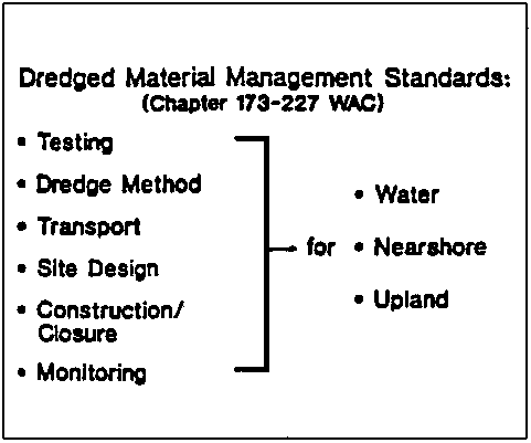
· Per Element S-4 of the Puget Sound Plan, Ecology is developing a second sediment rule addressing dredging and disposal of sediments derived from navigation and cleanup projects· Dredged Material Management Standards, Chapter 173-227 WAC, will specify technical and procedural requirements for all dredging and dredged material disposal actions
· Rule will codify key features of the current Puget Sound Dredged Disposal Analysis program
· Rule will provide “minimum functional standards” for disposal of sediments in upland disposal sites (pursuant to Chapter 173-304 WAC)
· Rule will be linked to the Dangerous Waste rule (Chapter 173-304 WAC) to address hazardous sediments
· Draft guidance manual due April 1992; draft rule scheduled for release by end of 1992

Sediment Management Standards
· Ecology recently adopted a new rule known as the Sediment Management Standards, Chapter 173-204 of the Washington Administrative Code· Rule establishes a set of narrative, chemical and biological criteria as 'sediment quality standards'
· Rule describes use of standards in existing source control programs designed to control the discharge of contaminants (e.g., wastewater discharge permits)
· Rule applies the sediment quality standards in the sediment cleanup decision process
· Rule was recently approved by EPA as part of the State's “water quality standards” pursuant to Section 303 of the Clean Water Act
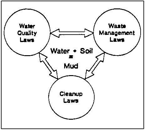
Institutional Challenges of Sediment Management
· Like water, sediments are an environmental medium and are subject to aquatic protection laws· Unlike water, if sediments are picked up, they are similar to any other solid waste material
· Contaminated sediments result in cleanup liabilities to the discharger, the waterfront developer and the landowner
· Sediment management requires an innovative blend of legal mandates and procedures to effectively integrate water quality, dredging and cleanup programs

Cross-Program Implications
· A key objective of the sediment rule was to ensure that the various government programs that affect sediment quality worked in harmony with one anotherIMPLEMENTING THE SEDIMENT MANAGEMENT STANDARDS· Same standards of quality are established for all regulatory programs
· We do not want permitted discharge zones that will then result in increased disposal costs and liabilities to navigation dredgers
· For cleanup programs, the upper standard is a cleanup trigger (“cleanup screening level”) above which we will list a site for active cleanup, below which we will not list a site for active cleanup
· The status of point and nonpoint source controls is a key consideration in determining appropriate cleanup actions in sediments
· This arrangement ensures that we will not be permitting discharges or creating dredged material disposal sites that will later become future cleanup sites.
Olga Rios Del Aguila1
1 Regional Agricultural Director, Ministry of Agriculture, Jr. José Gálvez No. 287, Pucallpa, Ucayali, PerúNote of the Editor: At the time of the publication of these proceedings, only the abstract of the presentation was available. Further details or the complete paper may be available by contacting the author at the specified address.
ABSTRACT
The Yarinacocha lagoon is located in the Ucayali region of Peru. The average annual temperature in the region is around 80°F (26.29°C) with an average precipitation of 70 inches/year (1777 m.m. year).
Since 1982 an increase of water hyacinth, water lettuce, and umbrella flatsedge has been observed. Approximately 15% of the surface area of the lagoon (180 Ha.) is covered with aquatic plants. In other lagoons and lakes almost 100% of the surface area is covered, making these water bodies unnavigable. In addition some of the plant roots are fixed in the soils creating secondary forests when the area dried out.
This invasion of aquatic plants is due to the disappearance of the manatees, tapirs, and fishes that were caused by boat traffic, human consumption and deforestation.
The principal methods of weed control are mechanical removal, herbicides that do not cause contamination and biological methods through the use of crickets and herbivorous fish.
There are also preventative methods such as promoting the reproduction of manatees, fresh water turtles, placing control on fishing and finding additional use for aquatic weeds such as food products and fertilizer.
![]()
The Role of Non-Governmental Organizations in Environmental Assessment in the Pantanal Region
Conserving Aquatic Ecosystems for Sustainable Development
Management of Aquatic Ecosystems - The Pantanal Case
The Everglades Nutrient Removal Project: Hydrology, Hydrodynamics and Operation
Lessons Learned from Five Decades of Wetland Restoration and Creation in North America
The Role of Wetland Filters in Ecosystem Restoration
Development of the Kissimmee River Restoration Plan: Lessons Learned and Recommendations for Comprehensive Restoration Projects
![]()
Joaquim Rondon Rocha Azevedo1
1 Executive Director of Sociedade de Defesa do Pantanal - SODEPAN, Av. Americo Carlos Da Costa 320, 79080-170 Campo Grande, MS, BrazilBy now everyone is more or less acquainted with the context of the Pantanal, a vast wetland system located in South America. It is a very complex region, with a very high level of interconnectedness among the subregions that form it as well as the neighboring regions. We could mention, as an example, how it's hydrology influences the whole La Plata region, both by slowing down the flow of water coming from the upper basin into the Paraguay river, and by filtering solids in suspension and thus turning that water clearer. The cultural integration among the different regions of La Plata river basin is another factor that adds to that complexity.
We believe that, in that context, environmental assessment, like any other environmental issue, needs an “ecosystem-level approach” in order to be effective. This “ecosystem-level approach” should lead to an integration, from the beginning, of the multiple aspects involved, such as biologic, physiographic, socio-economic, and policy! providing broad and coherent analysis and solutions.
We have found that this kind of approach for environmental assessment stresses two points: building capacity for analysis, and communications. In the course of SODEPAN's programs, we've identified some actions to be taken, as well as constraints, regarding these two points, which I would like to talk about. First, however, it is necessary to introduce you to SODEPAN.
SODEPAN stands for Sociedade de Defesa do Pantanal. It is a private, non-profit organization founded by land owners of the Pantanal concerned with the maintenance of the ecological balance of the region. In its eight years of existence, SODEPAN has worked jointly with other agencies in the research of behavioral and biological needs of “flagship” species of the Pantanal, the ecology of flooded areas, and migration of fish, just to name a few examples. It has also conducted a diagnostic survey of the local political base and attitudes toward conservation in each microwatershed of the Upper Paraguay river basin, and has initiated a coalition of environmental groups in the La Plata region to address development issues such as MERCOSUR and the Hidrovia.
A recent reorganization and strategic planning session prepared SODEPAN to integrate the broad effort for the conservation of the Pantanal, which involves many different actors. The two issues of environmental assessment I intend to address, communications and capacity building, should be focused by the organization's programs from the perspective of our positioning within this effort.
CAPACITY BUILDING
As for capacity building, we envision three major courses of action:
1. Develop capacity to assess major development schemesCOMMUNICATIONSDirect and indirect impact assessment is reasonably well developed already. We have participated in workshops to improve capability of analyzing environmental impact assessments (EIAs) with satisfactory results. However, sometimes this is not enough. Much of the assessment is based on incomplete studies, that reveal gaps in knowledge that must be fulfilled.
In addition, development projects are often related to other projects, which leads to the necessity for a broader understanding of the implications of each project in a wider development scheme, in order to make a comprehensive analysis. Using the example of the Hidrovia Project, it is predictable that it will influence other projects such as monocrop agriculture development in the west of Brazil, or the ZPE (zone for processing and exporting of industrialized goods) in Corumba.
2. Investigation of alternative scenarios
The need for the investigation of alternative scenarios can be explained in the context of the polarization between development and conservation that some development agencies suggest. We often run short of arguments to counter that position, because there are no studies that indicate the alternatives that can potentially integrate development and conservation. Elaborating models, assessing available technology that could be useful, and most important, valuing the natural resources and the potential economical losses due to bad use is essential.
3. Develop instruments for micro-scale planning
In a region where 95% of the land is privately owned, any conservation strategy needy support on that level. Environmental assessment must not only take this into account to be socially sound, but also be operational in orienting and promoting actions on that level. Rapid Environmental Assessment techniques can be a solution, in the sense that it is accessible. Also, in microwatershed actions and planning, like in Bonito or Rio Verde, it would be useful.
The complexity of the Pantanal region, and the number of actors involved in the process of its development create a demand for coordination among these actors, and most important, a necessity for consensus around the guidelines for the development of the region. This situation presents an opportunity for a number of actions, some of which SODEPAN is currently undertaking.
1. Educate involved community groupsPROBLEMS/OPPORTUNITIESIt is necessary to inform the involved community groups about development projects and policy making, in terms of their potential benefits and threats. In order to do that, we've developed a program with the following activities: Circulate information through media, create a telephone information system (hot-line), and increasing the circulation of the organization's newsletter.
2. Build sound terms of reference for development programs and policy-making
Once the communities are well informed, it is necessary to create mechanisms that ensure their participation in the decision-making process. SODEPAN is currently carrying out a program of public hearings that will provide the baseline for the Mato Grosso do Sul state environmental policy act. This program will be enhanced and incorporate the use of focus groups.
3. Develop methodologies/coordinate efforts
The coordination of efforts of the various groups involved in the process of development of the Pantanal is essential. Not one single group can undertake this task alone. SODEPAN envisions creating a computer network and hold meetings with environmental and development agencies of the whole La Plata region, thus supporting open debate regarding issues of common interest and the development of appropriate and comprehensive methodologies to address these issues. This network could also serve as an early warning system of activities that could potentially create impacts on the environment.
Even though many of the programs mentioned are already being carried out, SODEPAN still faces some major problems in getting them accomplished. It is a temptation to say that the major constraint to implement these actions is the lack of financial and technical resources. This is a reality in most of Latin American organizations, specially NGOs. However, I think that the challenge we face, the development of innovative methods to cope with complex scenarios such as the Pantanal, needs a bilateral, collaborative approach, in which local institutions would receive the resources, but would actively help adapting them to their specific reality. In return, methods developed from the integration of conceptual frameworks and real parameters, would certainly be useful once transposed to other complex scenarios. SODEPAN We certainly need help to overcome these constraints, but looking at them from the perspective of the opportunities they present, one sees that the whole matter is relevant not only on local level, but can also bring benefits to the whole world.
Gonzalo Castro, Ph.D.1
1 Executive Director, Wetlands for the Americas, P.O. Box 1770, Manomet, MA 02345, USAAquatic ecosystems, or wetlands, are an integral component of the water cycle and are thus inextricably linked with the management of water resources. Given the variety and importance of the services that wetlands provide to society, their conservation must be a central component of any rational strategy for the long-term utilization of water. In this paper, I review the connections between aquatic ecosystems (i.e. wetlands) and sustainable development, and stress the need for society to incorporate wetland conservation within the formulation of water use policies.
WETLANDS: DEFINITIONS AND TYPES
Wetlands, or aquatic ecosystems, are defined by the Convention on Wetlands of International Importance (Ramsar Convention) as “Areas of marsh, fen, peatland or water, whether natural or artificial, permanent or temporary, with water that is static, flowing, fresh, brackish or salt, including areas of marine water, the depth of which at low tide does not exceed six meters.” As a descriptive definition, it is broad and encompasses a variety of aquatic ecosystems, including reef and seagrass beds, mudflats, mangroves, estuaries, rivers, marshes, swamp forests, and lakes. Because this is a definition in an international convention, it is often adopted as the “official” definition of a wetland (Davies and Claridge 1993).
There are numerous ways to classify wetlands, and a variety of criteria can be applied to this end. Again, the Ramsar classification is widely recommended (Dugan 1992), and includes Salt Water Wetlands (Marine, Estuarine, Lagoonal, and Saline with internal drainage); Freshwater Wetlands (Riverine, Lacustrine, and Palustrine); and Man-Made Wetlands (Aquaculture/Mariculture, Agriculture, Salt Exploitation, Urban/Industrial, and Storage).
WETLAND LOSS AND DEGRADATION
Traditionally, wetlands have been considered useless ecosystems. Widespread ignorance about the important benefits that wetlands provide to human societies has contributed to this notion, promoting the destruction and degradation of wetlands throughout the world.
The conterminous U.S. has lost an estimated 53-55 percent of its original wetlands. By the 1980's, twenty-two states had lost 50 percent or more of the wetland areas that were contained within state borders (Dahl 1990). This loss is equivalent to an area larger than the state of California, and translates into a loss of one acre every single minute for the last two hundred years. Many human activities are responsible for the draining, filling, flooding, and degradation of wetlands and riparian habitats. Agriculture, dams and flood control projects, road building, urban development, pollution discharges, groundwater pumping, and deforestation are important agents of wetland destruction. Most wetland degradation occurs from changes to the land base, primarily due to agriculture (Dahl, pers. comm.).
Although reliable figures are not available for other countries in the hemisphere, evidence indicates that wetlands are rapidly being destroyed and degraded everywhere. Many countries that have been studied have shown losses in mangrove cover of more than 50%. Throughout Mexico and the Caribbean, many coastal wetlands have been lost because of tourism expansion. Agricultural runoff and other sources of contamination are also a serious threat in South America, especially in the La Plata Basin. Mining waste is dumped directly into many high Andean lakes, especially in Peru and Bolivia. Conversion to rice fields is also a serious problem, especially in Uruguay and Brazil. These losses erode many important wetland benefits and impinge upon their ability to act as the basis for future sustainable development.
SERVICES THAT WETLANDS PROVIDE TO SOCIETY
Wetlands provide a great variety of benefits to society. These benefits are often referred to as functions, uses, values and attributes, features, and goods or services, and are defined as any of these terms which may have a value to people, wildlife, natural systems or natural processes (Claridge 1991). According to Adamus and Stockwell (1983), there are about 75 such characteristics of wetlands that can be considered beneficial. In this paper, I classify wetland benefits as functions, products, and attributes following Davies and Claridge (1993) and Dugan (1992).
Wetland Functions
Water Supply. - Includes direct extraction of water by people, water supply to an aquifer (groundwater recharge), groundwater discharge, and water supply to another wetland. The value of these functions is illustrated by an example from the state of Massachusetts (USA), where 60 communities, a total of 750,000 people, depend on groundwater supplied by wetlands to fulfill their water needs (Motts and Heeley 1973, in Dugan 1992). Conversely, intensive mariculture in Malaysia that relies on groundwater, coupled with a high rate of wetland destruction, has depleted groundwater supplies to local communities (Davies and Claridge 1993).
Flood regulation. - This function occurs both through flood water storage, and through flood slow downs by wetland vegetation. The disappearance of millions of acres of wetlands along the Mississippi River watershed played a critical role in amplifying the magnitude of the 1993 floods, with the ensuing loss of lives and property, estimated at more than 10 billion dollars. In a similar fashion, the Pantanal in Brazil and Bolivia slows the flow of water in the Paraguay river, thus avoiding catastrophic flooding downstream. It is well documented that the loss of this “sponge” function would produce extensive damage to rich agricultural areas in Argentina (Bucher et al. 1993). Another study showed that if 40% of the wetlands along the Charles River in Massachusetts (USA) were drained, flood damage would increase by a minimum of $3 million/year. If they were completely drained, however, the damage would have been $17 million/year (Dugan 1992 and references therein).
Prevention of Saline Water Intrusion. - This function is especially important in coastal areas where saline intrusion negatively impacts the availability of fresh groundwater. This function also occurs at the surface, where water flow usually limits seawater entry (Davies and Claridge 1993).
Protection from Natural Forces. - This includes shoreline protection from storms and stabilization, the provision of windbreaks, and erosion control. The destruction of coastal wetlands often results in tremendous loss of life and property. Where bankside vegetation has been destroyed along rivers in England, the cost of reinforcement is estimated at $425 per meter (Turner 1989). In Bangladesh, tens of thousands of people are killed periodically by storm surges that could be prevented through the conservation of coastal wetlands.
Sediment retention. - This function benefits communities downstream by maintaining water quality, and benefits agriculture by renewing nutrients and soil.
Nutrient retention and toxicant removal. - This function maintains water quality by absorbing excessive nutrients and removing toxicants from the water. In the Florida (USA) cypress swamp, 98% of all nitrogen and 97% of all phosphorus are removed from wastewater this way. In Massachusetts (USA), a study showed that the cost of replacing the tertiary waste treatment services provided by wetlands was $123,000 per hectare (Oldfield in Dugan 1992).
Biomass export. - The high productivity rate in wetlands yields biomass that is often exported and utilized, especially by fisheries downstream.
Micro-climate stabilization. - As part of their role in the hydrological cycle, wetlands equalize climate, especially rainfall and temperature.
Global Carbon Sink. - Many wetlands hold large amounts of carbon in the form of peat, that if released, could significantly add to the global carbon problem and thus to global warming (Davies and Claridge 1993).
Water transport. - This is an important function, especially in rural areas where wetlands serve to transport people and products between adjacent communities.
Tourism. - Wetlands support a heavy recreational industry that includes opportunities for hunting, fishing, birdwatching, etc. In Canada, for example, the value of wetland recreation is estimated at U.S.$4 billion/year. The overall tourism industry provided $55 billion to developing countries in 1988 (Davies and Claridge 1993; Dugan 1992).
Wetland Products
The high rate of primary productivity in wetlands results in the availability of a variety of products, including forest resources, wildlife resources, fisheries, forage resources, agricultural resources, energy resources, etc. The value of these products is often measured in millions of dollars annually for any given locality, and represents an important source of income for rural communities.
Two-thirds of all fish caught commercially depend on wetlands at one point or another of their life cycles. This percentage increases in some fisheries, such as the Gulf of Mexico, where 90% of the fish harvested (worth $700 million annually) consist of species dependent upon coastal mangroves (Dugan 1992).
Peat is used as an energy source in many rural areas. In Perú, peat, called champa, is regularly used as a household fuel, especially for cooking (Pulgar-Vidal 1946).
Wetland Attributes
Although it is often difficult to assign a monetary value to wetland attributes, these benefits nonetheless represent an important resource that needs to be conserved for ethical, aesthetical, cultural, and biological reasons.
Biological Diversity. - Some of the most spectacular diversity and concentrations of wildlife, both resident and migratory, occur in wetlands. Wetlands often play critical roles in the life-cycle of many species. The disappearance of wetlands have been documented to impact heavily upon the population of migratory species of birds (Castro et al. 1990). A recent study has shown that although wetlands represent less than 5% of all the land area of the U.S., they harbor about 50% of all endangered and threatened species (Feierabend 1992).
Gene Bank. - The use of genes from wild species occurring in wetlands is an important way of improving cultivated varieties of plants. In addition, wetlands can host inordinate amounts of the genetic composition of some species. In some migratory shorebirds, for example, up to 60%-90% of all individuals are sometimes found within a single wetland (Morrison and Ross 1989).
Socio-cultural Significance. - Wetlands are significant components of the landscape providing aesthetic values; are associated with religious and spiritual beliefs and activities; help maintain important cultural elements; and are often sites of historic importance (Davies and Claridge 1993). According to tradition, the first flag of Peru was conceived by General San Martin while observing flamingoes in Paracas, Perú. This historic event helped in the creation of the Paracas National Reserve in Peru and adds to its importance as a site of national heritage value (Davies and Claridge 1993).
WETLANDS AS A BASIS FOR SUSTAINABLE DEVELOPMENT
Valuation
Public policy requires economic valuation of the public benefits of wetland conservation. Since most wetlands provide several of these benefits simultaneously, the total value of a wetland thus cannot be accurately estimated unless all functions, products, and attributes are incorporated into the calculations (James 1991).
Quantification at the local scale for the harvestable products such as food and fuel is straightforward. Recreational and aesthetic values of wetlands, and their diversity of plants, fish, and wildlife can also be approached with conventional economic methods based on the businesses supported by recreational experiences, or based on willingness to pay for the recreational experience (Castro et al. 1994).
Higher ecological values are external to the market system because the benefits are accrued by society as a whole. Attempts have been made to assign economic value to these functions based on what it would cost to replace the function, or by depreciating the natural capital that is eroded when a natural resource is depleted (Solórzano et al. 1991).
Regardless of the method utilized, it is clear that the very valuable benefits that wetlands provide to society must be somehow incorporated within national accounting schemes in order to change the perception that wetlands are useless ecosystems, and to promote the conservation of their valuable benefits.
The Huanchaco Extractive Reserve in Peru: An Example of Sustainable Use
The Huanchaco Extractive Reserve in northern Perú illustrates how the many benefits that wetlands provide to society can be incorporated within a community development scheme. This project is currently being implemented by the Wetlands of Perú Program, a consortium of governmental and non-governmental agencies in Peru, and is a priority of the National Wetlands Conservation Strategy of Peru (Pulido et al. 1992).
Archaeological evidence suggests that coastal wetlands have been managed in Peru for at least 2,000 years. Many ancient civilizations were organized along the coast to benefit from a variety of wetland products, that included birds, eggs, fish and mollusks, peat (as fuel), and cattail (Typha) fibers. Many of these products were utilized for the manufacturing of tools, containers, housing, and fishing vessels. The clearest evidence of active wetland management comes from Chan Chan, a large precolumbian city in northern Perú (population estimated to be between 20,000-100,000 by 1,500 A.D.). The city included several large artificial wetlands that were communally managed to obtain a variety of products, primarily cattail fibers used for housing and building fishing vessels (Rostorowski 1981 and references therein).
After the Spanish conquest, these traditions were abandoned in most coastal areas. Even though today it is possible to find wetland products extracted from coastal wetlands, the wetlands themselves are not actively managed. The Chan Chan system, however, was the only location where ancient wetland management was still practiced until ca. 1940. At this time water sources that maintained these artificial wetlands vanished because of competition from expanding agriculture in the basin. Local fishermen, who relied on these products to build their fishing vessels (“totora horses or caballitos de totora”) were forced to start managing natural wetlands in the Huanchaco area, a few miles away, and to build additional artificial wetlands. The Huanchaco wetlands have been continuously managed since ca. 1940. Because the management of Huanchaco was based on the Chan Chan system, it represents a traditional management system that can be traced back thousands of years (Rostorowski 1981).
Today, more than 500 people, mostly fishermen, directly depend upon the totora extracted from Huanchaco for survival. Huanchaco was declared an “Extractive Reserve,” in 1992, covering an expanse of 4,672 hectares (Valqui and Zegarra 1993).
The main goal of the Huanchaco Project is to rescue the ancient techniques of wetland management in coastal Perú, by developing a demonstration project. Specific objectives include: to document the ancient techniques of coastal wetland management and to study their adaptation within a contemporary context; to refine these techniques to maximize their values for biodiversity conservation; to explore the development of alternative markets for the wetland products generated; and to promote the utilization of these techniques in additional wetlands along the coast of Perú.
Although in its initial stages, this project will provide important benefits at several levels. It will rescue techniques that can be used for the sustainable management of wetlands, while providing important habitats for biodiversity. In addition, it will help conserve this important site, its biological and cultural values, and the 500 people that depend upon it. It will serve as an international showcase demonstrating that wetlands can be sustainably managed to benefit both people and biodiversity.
The project will also help elevate the standard of living of local communities, and will develop economic incentives for wetland conservation. It will provide important scientific information, including a better understanding of the system, the factors limiting productivity and species richness, and a clear description of the management system. Finally, it will help conserve the last location where a cultural tradition has been continuously utilized for more than 2,000 years. The potential to reproduce this model along the coast of Peru (and potentially northern Chile) is very large. The project will help develop an approach that integrates conservation with the development of economic benefits to local populations.
CONCLUSIONS AND RECOMMENDATIONS
The conservation of aquatic ecosystems is inextricably linked with the long-term availability and management of water resources. Wetlands provide a variety of direct services to society, including water supply and purification, flood control, aquifer recharge, riverine flow regulation, prevention of saline water intrusion, sediment and nutrient retention, toxicant removal, energy production, and many others. In addition, wetlands are critical habitats to a rich biodiversity, and include more than 2/3 of all fish caught commercially. Wetlands provide unmatched opportunities for recreation and are an integral part of the national heritage of many countries.
Because these services are not incorporated into national accounting schemes, they are assumed to be free, resulting in the widespread destruction of these ecosystems. Wetland loss has been very severe, with some countries, such as the U.S., having lost more than 50% of all their wetlands. The accelerated destruction of wetlands throughout the Americas eliminates these services and erodes the basis for future sustainable utilization of water resources. The 1993 severe floods in the mid-western United States were amplified many-fold by the loss of wetlands and their flood control services along the river. Examples illustrating the direct connection between wetlands and water resources management abound.
Any long-term, rational scheme for the management of water resources must recognize the complex but critical connections between the health of aquatic ecosystems and the long-term availability of clean water. The conservation of wetlands and their benefits is therefore sustainable development in its purest form.
REFERENCES
Adamus, P.R., and L.T. Stockwell. 1983. A Method for Wetland Functional Assessment. Vol 1: Critical Review and Evaluation Concepts. U.S. Department of Transportation, FHWA-IP - 82-83. Washington, DC. 178 pp.
Bucher, E.H., A. Bonetto, T. Boyle, P. Canevari, G. Castro, P. Huszar, and T. Stone. 1993. Hidrovia: An Initial Environmental Examination of the Paraguay-Paraná Waterway. Wetlands for the Americas, Manomet, USA, and Buenos Aires, Argentina. 70 pp.
Castro, G., F.L. Knopf, and B.A. Wunder. 1990. The drying of a wetland. American Birds 44: 204-208.
Castro, G., et al. 1994. Wetland and bird conservation in North America. American Ornithologists' Union Wetland Conservation Sub-Committee. Ms. in preparation.
Claridge, G.F. 1991. An Overview of Wetland Values: A Necessary Preliminary to Wise Use. PHPA/AWB Sumatra Wetland Project Report No. 7, AWB, Bogor.
Dahl, T.E. 1990. Wetland losses in the United States 1780's to 1980's. U.S. Department of the Interior, Fish and Wildlife Service, Washington, D.C. 13 pp.
Davies, J., and C.F. Claridge (Eds.). 1993. Wetland Benefits. The potential for wetlands to support and maintain development. Asian Wetland Bureau, International Waterfowl and Wetlands Research Bureau, and Wetlands for the Americas.
Dugan, P.J. (Ed.). 1992. Conservación de Humedales. Un análisis de temas de actualidad y acciones necesarias. IUCN, Gland, Suiza. 100 pp.
Feierabend, J.S. 1992. Endangered species, endangered wetlands: Life on the edge. National Wildlife Federation, Washington, DC. 50 pp.
James, R.F. 1991. The Valuation of Wetlands: Approaches, Methods, and Issues. PHPA/AWB Sumatra Wetland project Report No. 29, Bogor. 95 Pp.
Morrison, R.I.G., and R.K. Ross. 1989. Atlas of Nearctic shorebirds on the coast of South America. Canadian Wildlife Service Special Publication. Two volumes, 325 Pp. Canadian Wildlife Service. Ottawa.
Pulgar-Vidal, J. 1946. Historia y Geografía del Perú. Tomo I: Las Ocho Regiones Naturales del Perú. Universidad Mayor de San Marcos, Lima, Perú. 256 Pp.
Pulido, V., G. Castro, M. Rios, G. Suárez de Freitas, and J. Ugaz. 1992. Bases para el establecimiento del Programa de Conservación y Desarrollo Sostenible de Humedales, Perú. INIIA, Lima. 40 pp.
Rostorowski, M. 1981. Recursos naturales renovables y pesca. Siglos XVI y XVII. Instituto de Estudios Peruanos, Lima. 180 Pp.
Solórzano, R., R. de Camino, R. Woodward, J. Tosi, V. Watson, A. Vásquez, C. Villalobos, J. Jiménez, R. Repetto, and W. Cruz. 1991. Accounts Overdue: Natural Resource Depreciation in Costa Rica. World Resources Institute, and Tropical Science Center. Washington, DC, and San José. 110 Pp.
Turner, K. 1989. Market and Intervention Failures in the Management of Wetlands: Case Study of the United Kingdom. OECD, Paris. 62 Pp.
Valqui, T., and R.E. Zegarra. 1993. Evaluación preliminar de los humedales totoreros de Huanchaco, Trujillo. Unpublished report to Wetlands for the Americas. 8 Pp.
Agostinho Carlos Catella1
1 Researcher, Empresa Brasileira de Pesquisa Agropecuária - Centro de Pesquisa Agropecuária do Pantanal (EMBRAPA/CPAP); R. 21 de Setembro, 1880, CEP 79320-900, Corumbá, MS, Brazil.The greatest challenge regarding the Pantanal, as any other little modified ecosystem, is how to orient its occupation and development aiming the maintenance of biodiversity and quality of life. Actions to be taken, in addition to political will, depend on the knowledge about the structure and functioning of these environments we may have.
The Center for Agriculture Research in the Pantanal (CPAP) is one of the 45 units of The Brazilian Company of Agriculture Research (EMBRAPA), located in the city of Corumbá, in the center of Pantanal. It has as institutional mission to generate, adapt, and transfer knowledge and technologies that may contribute to the sound and sustainable development of Pantanal.
The Center is currently composed by 40 researchers, among which there are 6 hold doctorate (Ph.d.), 30 magister (M.Sc.), and 4 undergraduate level degrees. They represent the following fields: Wildlife, Fishing Resources, Plant Resources, Cattle Ranching Production Systems, Animal Health, Soils, Climatology, Hydrology, Limnology, Socio-Economy and Technology Transfer. It also counts on 147 employees for research support and administration and two farms in the Pantanal.
1. Characteristics of the Pantanal
The Pantanal is an extensive alluvial plain located in the center of South America. Its floodplain area occupies about 140,000 square kilometers, with the Paraguay River running north to south as its principal stream. Geographically, the Pantanal is located in the Brazilian central-west, with smaller areas in northeastern Paraguay and southeastern Bolivia.
The basin is regulated by a hydrological pulse regime. Seasonal variations of flooding and drought determine a process of ecological succession, with the installation and development of species during the wet season, and another during the dry season. This fact, associated with the high temperatures and humidity, ensures the high productivity of the ecosystem. Pluri-annual periods of alternacy of drier and more wet cycles determine the length of floodings and therefore the availability of habitats and resources for the species. These variations influence the antropic occupation and regional economic activities.
The Pantanal is composed of various sub-regions, with different soil, vegetation and hydrological characteristics, creating a mosaic of habitats that enables the existence of a great number of plant and animal species. Also, its geographic position allows for the interchange of species with other important Latin American biomass such as Amazon “Cerrado”, the Atlantic Rain Forest or “Mata Atlántica”, and the Chaco.
2. Productive Systems
Cattle Ranching
Cattle Ranching, initiated more than 200 years ago, is the main economic activity in the region. It is carried out under traditional standards on big “fazendas” (farms). At present, the herd has some 3.8 million heads raised on an extensive basis, with a density of one animal per 3.6 hectares, and US$ 60 million. The herd feeds basically on native grasses. During the dry season, there is a loss of quantity and quality of the pastures, and during the wet season there is a reduction in the area available for pasture. To buffer this seasonably in food supply, many farmers have been introducing, in the last 20 years, exotic grasses in the field and non-flooding forest areas. Cost-benefit studies are necessary regarding this issue, for these areas represent feeding, reproduction and shelter habitat for many animal species.
Fishing
Fishing is an activity of strong regional socio-economic significance, both in its professional/subsistence and touristic forms. Basically 8 major species are captured. Professional/subsistence fishing gathers some 7,500 fishermen, generally associated with cooperatives and fishing communities. The majority has only the lower level of formal education, and live in the borders of riverside cities.
Fish capture an average 1.51/4.55 ton/year, and yearly total reaches an estimate 8,000 ton/year. Fish is marketed “in natura” as protein for human consumption. Meanwhile, it is desirable to improve the economic performance per captured fish. In order to do that, CPAP is researching the viability of using sub-products as the skin, and the bones for flocer and oil. Tourist fishing is responsible to a massive fish capture, due to the 60,000 fishers that come from all over Brazil to the Pantanal.
Over 250 fish species have been listed in the Pantanal. They perform a very important ecological role in energy flux and nutrient cycling. Moreover, they represent the staple food for many reptiles, mammals and especially migratory birds that nest in the region. CPAP has conducted some studies about community structure, diversity and feeding of fish. CPAP is currently conducting a study on the feeding of around 100 species of the Miranda River floodplain that will lead to the elaboration of this communities food web.
Meanwhile, there are many important questions to be answered, as well as biological phenomena to be quantified. Because of the lack of scientific information, current fishing regulation is very restrictive. It only allows the use of hooks, prohibiting nets, and imposes a three month non-fishing season, during the breeding and reproduction period. This causes a strong economic impact upon the sectors that depend on fishing.
CPAP is proposing a research program to produce information to support the design of a management plan for fish resources in Pantanal. Projects include:
· assessment of Fish stock of main species explored by professional and tourism fishing; andThis plan will technically support fishing regulation in order to achieve a better and more sustainable use of fish resources. Among the regulations studied are minimal size for capture, protection areas, closing season, allowed fish equipment, and allowed amount of capture for professionals and amateurs.
· study of the growth, reproduction and feeding of these species.
In the 1980's, the Tucunaré, a Cichidae predator fish from the Amazon basin, was accidently introduced in the Pantanal. This phenomena is being studied in two phases:
· Study on the biology and speed of expansion of this species in the Pantanal;Tourism
· Assessment of its impact upon the rest of the fish community.
The scenic beauty of the Pantanal, marked by richness of its fauna, diversity flora and variation of aquatic ecosystems, give the region an excellent potential for the development of eco-tourism and environmental education activities. In addition to sports fishermen, the region annually receives around 100,000 tourists, of which 70% come from abroad, particularly from Germany, Italy and Spain. The great tourism potential of the region demands studies and planning, in order to make eco-tourism an important column in the region's economy and support the sustainable use of the system.
As far as cattle ranching is concerned, tourism could be an important economic alternative for ranchers, once this activity has very specific characteristics in region, architecture, costumes, hand-work, traditional uses, food and cattle management, became very peculiarly adapted to the Pantanal region in the course of 200 years of its occupation.
3. Alternative Productive Ecosystems
The richness of animal and plant species, together with a raising demand for natural products, offer a possibility for increasing producer's income as well as job offers through the sustainable use of this resources.
Flora
The main plant resource of the Pantanal is its natural grasslands, which range from aquatic vegetation to trees, upon which the herd and grass eating fauna depend. On the ranches, plants are used for wood, leather, roofing, medicine, insect keeling, fibers and food. There are many medicinal plants with good potential for extraction, in addition to others yet unexplored. Some isolated cases of use for commercial purposes, such as for food, medicine, charcoal and artisan crafts are observed. Deforestation and uncontrolled fire are threats to the great unexplored potential of plant resources in Pantanal.
The CPAP's herbarium is the greatest collection of plants of the Pantanal. It houses more than 8,000 specimens of which 1,500 are identified species. A work with information, phenology, popular use and main characteristics of all arbor-shrubs, gramineas, and aquatic macrophytes already identified will be published soon.
Fauna
The extraction of faunistic resources of the Pantanal, except for ictiofauna, is forbidden by Brazilian laws, due to the lack of knowledge about biology of species and population dynamics. Fauna represents big enforcement costs for both the state and federal government, especially in the Pantanal, because of the extensive size of the region, the length of international borders and the difficult access. Past experiences have proven unsuccessful control of hunting and poaching just with the implementation of enforcement. It could be more promising to value fauna, so that the landowners would be interested in the sustainable use of these resources. At the same time, they would be stimulated to conserve this animal's habitats, and indirectly to preserve other species with no economic value, with no additional cost. This economic alternative to the existing productive system could reduce further the uncontrolled introduction of exotic grasses as well as other high impact activities.
Currently, the main target species for poaching are: caiman, lizards, anaconda, birds and felines. Together, they represent millions of dollars that could be contributed to the socio-economic development of the region.
4. CPAP Sustainable Wildlife Conservation Program
At present, CPAP is carrying out a program for the execution of the ecological studies applied to the conservation and technologies for the sustainable use of wildlife in the Pantanal. The sub-projects under this program are:
· aerial monitoring system of the distribution and abundance of large vertebrates in the Pantanal;In order to carry out this ambitious program, CPAP has established partnerships with the several governmental agencies including: Federal University of Mato Grosso do Sul (UFMS), CECITEC, State Secretariat for the Environment of Mato Grosso do Sul (SEMA-MS), the Brazilian Institute of Environment (IBAMA), National Council of Research (CNPq), FINEP, the British Council, University of Florida at Gainesville, and the following non-governmental agencies: Fundação o Boticário, Sociedade de Defesa do Pantanal (SODEPAN), Conservation International, and World Wildlife Fund (WWF).· experimental studies for the sustained use of natural populations of jacaré and capibara in the Pantanal;
· experimental studies for the sustained use of feral populations of pigs.
However, execution of this and other programs under CPAP's mission are hindered by major constraints, such as:
· Lack of resources and training for the maintenance of facilities and equipment;CPAP is actively pursuing additional partnerships to foster the sustainable management and research of wetlands systems. The Pantanal, due to its vast extension and diversity, has found analogues in other latitudes Among these analogues are the Florida Everglades, the Orinoco Delta, and other smaller wetlands systems scattered throughout the hemisphere. Institutions in these areas are welcomed to visit the Pantanal and share the wealth of information that would enable the preservation and adequate management of these ecosystems for the enjoyment of future generations.
· Lack of financial resources for the acquisition of capital equipment and materials;
· Training of personnel and the necessity for consulting services.
M. Guardo, PhD, PE; W. Abtew, PhD, PE; J Obeysekera, PhD, PE; and J. Roy1
1 Sr Civil Engineer, Sr Civil Engineer, Supervising Professional Civil Engineer, and Civil Engineer respectively. Department of Research, South Florida Water Management District, P.O. Box 24680, West Palm Beach, Florida 33416-4680, USAINTRODUCTION
The Florida Everglades is a unique ecosystem which sustains a variety of flora and fauna that are specific to the region. This ecosystem has been affected by many factors, both natural and anthropogenic. Changes to the natural hydroperiod and increased nutrient enrichment of inflow waters have transformed the floral and faunal communities of the Everglades (Davis, 1991; Koch and Reddy, 1992; Swift and Nicholas, 1987). The increased nutrient loading, primarily phosphorus (P), is largely due to agricultural runoff from the Everglades Agricultural Area (EAA). The 1991 Marjory Stoneman Douglas Everglades Protection Act (Section 373.4592 Florida Statute) requires the South Florida Water Management District (District) to regulate water quality in the Everglades system. The District proposes the development of Storm Water Treatment Areas (STAs) for reducing the P loading to the Everglades. These wetland treatment systems will function as nutrient filters.
The Everglades Nutrient Removal (ENR) project is the first wetland to be constructed and will initially function as a demonstration scale project. This 1500 ha (3700 ac) system, currently one of the largest constructed wetlands in the world, is designed to use different types of vegetated marshes to reduce the total P concentrations and loads in the EAA drainage water. The primary objectives of the ENR project are; 1) to reduce the amount of P in the water flowing into the Loxahatchee National Wildlife Refuge (Water Conservation Area 1, a regulated wetland system which was part of the original Everglades), and 2) to develop wetland treatment design criteria, operation schedules, and maintenance requirements for large scale application of wetland treatment systems (Everglades Systems Research Division, 1993). The experience gained from the ENR project will be used to optimize wetland design and operation of large scale STAs for treating agricultural runoff from over 200,000 ha (500,000 acres) of agricultural drainage basin. The ENR project differs from many other constructed wetlands due to its size, pulsed loading of water, quantity of water to be treated, total P concentration range in which it will operate, and low 0.05 mg l-1 (50 ppb) total P discharge requirement (Newman, et al, 1993). The purpose of this paper is to describe the hydrology, hydraulics, and operation of the Everglades Nutrient Removal constructed wetland.
SITE DESCRIPTION
The ENR project site has highly organic soils and flat topography and is located in South Florida, about 32 km (20 miles) west of the city of West Palm Beach (Figure 1). Originally, the area was part of the natural Everglades system that consisted of custard apple and willow-elderberry swamps and sawgrass marshes interspersed with tree islands, wet prairies and sloughs (Davis, 1943). Since drainage and agriculture started in the area over six decades ago, about 1.52 m (5 ft) of the top muck soil has been lost due to soil subsidence, oxidation and shrinkage. At present, the surface 1-2 m (3.28 ft to 6.56 ft) is peat that overlays several meters of carbonate rock (Jammal and Associates, 1991).
The average ground elevation is 3.05 m (10 ft NGVD). A 12 km (7.5 miles) long perimeter levee, excluding the L-7 levee, surrounds the constructed wetland and the enclosed area is divided by internal levees into four treatment cells (Figure 2). The northern two parallel treatment cells (Cell 1 and Cell 2), referred to as Flow-way Cells, are being vegetated mainly through natural regrowth of cattails. The southern two cells (Cell 3 and Cell 4) are referred to as Polishing Cells. Polishing Cell 3 is planted with mixed marsh vegetation composed of Pickerelweed (Pontederia Cordata), Arrowhead (Sagittaria latifolia), Duck Potato (Sagittaria lancifolia), Maidencane (Panicum hemitomon), Sawgrass (Cladium jamaicense) and Spikerush (Eleocharis spp.). Emergent macrophyte growth will be controlled in Polishing Cell 4 and it will be operated as a submerged/algal based vegetation system. A strip of natural regrowth will occur at the outlet of Cell 4. This vegetated area will function as a filter strip to minimize algal outflow.
HYDROLOGY
Hydrologic characteristics are probably the primary factors that influence and determine the establishment and maintenance of specific types of wetlands and wetland processes. Hydrology creates unique biological, chemical and physical conditions that make wetland ecosystems different from well-drained surface water systems and subsurface aquatic systems (Mitsch and Gosselink, 1986).
To evaluate the nutrient removal performance of the ENR project, nutrient mass and hydrologic budgets are required. A comprehensive water quality and quantity monitoring program was developed to provide parameter data necessary to accurately determine nutrient and hydrologic budgets. Water budgets will be calculated by monitoring rainfall, evapotranspiration, surface inflows, surface outflows, and seepage in and out. The balance of all the above components yields a change in storage, which represents the seasonal pattern of water stages within the wetland.
Rainfall
South Florida has a humid subtropical weather pattern with warm rainy summers and mild winters. Most of the rain occurs in the summer and fall. The wet season extends from the beginning of June to the end of October. In the Everglades Agricultural Area where the ENR project is found, 66 percent of the annual rainfall occurs during the wet season on the average (Abtew and Khanal, 1993). Wet season rainfall is from convective rainfalls, localized thunderstorms, tropical depressions and hurricanes. The dry season (November through May) rainfall is mainly frontal rainfall. The historical (1929-1991) average annual rainfall for the area is 133.2 cm (52.4 inches) (Abtew and Khanal, 1993).
An accurate water budget of the ENR constructed wetland is required to evaluate and improve the performance of the treatment system. Rainfall, one of the largest components of the water budget, needs to be measured as accurately as possible. Summer rainfall patterns indicate the occurrence of highly localized convective rainfall. Accurate areal rainfall measurement therefore requires a network with a high gage density. The decision was made to install ten continuous recording, ripping-bucket raingages to establish the extent of spatial and temporal variability of rainfall within the ENR. Data from this ten gage network will be used to compute hourly and daily areal rainfall for each cell and the whole site based on the Thiessen method. After one year of data collection, the network will be reevaluated and the number of stations may change according to results of this network analysis. The raingage network is shown in Figure 3.
Evapotranspiration
Another major component of the ENR hydrologic system is evapotranspiration (ET). Initially, evapotranspiration will be measured with lysimeters (Abtew et. al., 1993). Lysimeters will be installed in each of three vegetation communities; cattails, mixed marsh, and algae covered open water without macrophytes (Figure 3). Actual evapotranspiration measured from the lysimeters, will be used for water budget computation. An illustration of the lysimeter is shown in Figure 4. High resolution weather data will be collected at the site for calibration of the Penman-Monteith equation using concurrent measurements of evapotranspiration with the lysimeters.
Surface Inflows and Outflows
Water is supplied to the ENR Project via a pump station (G-250). Records for the pump operations will be used to determine discharges into the entrance (Buffer) cell. Water is moved from one cell to another by means of 16.76 m (55 ft) long and 1.83 m (6 ft) diameter circular culverts with risers. A riser consists of an upright half-culvert which contains stop logs acting as a variable height weir. The culverts operate under full flow with downstream control. Water, initially pumped into the Buffer Cell, can be routed into Cell 1 through a series of ten culverts with risers (G-252A-J) or Cell 2 through a series of five culverts with risers (G-255A-E). These 15 risers are 2.1 m (7.0 ft) in diameter. Outflows from Cell 1 are routed to Cell 3 through a series of ten culverts with risers (G-253A-J) and from Cell 2 to Cell 4 through a series of five culverts with risers (G-254A-E). These 15 risers are 3.7 m (12.0 ft) in diameter. Water exits Cell 3 and Cell 4 into collection canals and is discharged from the project through the outflow pump station (G-251). Records for the pump operations will be used to determine discharges into the Water Conservation Area 1 (WCA-1), supported also by ultrasonic velocity meter (UVM) measurements in the discharge canal. The locations of surface water control structures are shown in Figure 2.
To meet objectives of the ENR project, accurate determinations of hydrologic and nutrient budgets for each treatment cell are required. Preliminary modeling of the ENR Project indicated that 30 percent of the time low flow conditions with culvert velocities less than 6.1 cm s-1 (0.2 ft s-1) will exist. Under low flow conditions, the resulting head differential, which is on the order of a hundredth of a foot, does not permit use of stage-discharge equations to accurately calculate flow through the culverts. Therefore, alternative methods for monitoring inflows to and outflows from each treatment cell were evaluated. Previous experience has shown that electromagnetic velocity meters are not reliable under very low flow conditions and are very sensitive to fouling. Any debris or growth contacting the sensor will generate erroneous data. Hence, these meters would require extensive maintenance. Use of mechanical velocity meters to monitor flow requires that they be mounted near the center of the culvert cross section. This design is susceptible to fouling from water column debris and breakage by alligators.
Through peer reviews of the hydrologic monitoring system it was suggested that UVMs could be utilized to determine inflows and outflows to each treatment cell. UVMs operate using a bidirectional transmission of sonic energy between two transducers aligned at some angle to the flow. This technique is based on the principle that a pulse of sound traveling diagonally across a stream will be accelerated by the velocity in the downstream direction and will be decelerated when traveling in the upstream direction. Velocity is computed from the difference between the forward and backward travel time and the angle in degrees between the acoustic path and the flow.
SEEPAGE
To estimate horizontal seepage into and out of the ENR project, 12 pairs of staff gages and 12 piezometers, located along the perimeter and interior levees, will be used to determine water level gradients. Readings from staff gages and water levels in the piezometers will be collected at the same time in order to accurately determine head gradients. Water levels will be monitored with continuous recording stage gages and periodically read staff gages located throughout the site. Seepage rate coefficients will be determined from tests, and be used to estimate seepage based on head gradient data.
HYDRODYNAMIC MODELING
Some of the most important parameters affecting nutrient removal in wetland treatment systems are intimately related to water processes. Parameters such as water depths, hydraulic loading rates (HLR), and hydraulic retention times (HRT) can be obtained from hydrodynamic modeling simulations, and play an important role in designing wetland systems for nutrient removal. Hydrodynamic modeling is, in these circumstances, of extreme importance when interacting with water quality modeling. The capability of a model to simulate and predict water quality is dependent on its ability to simulate all the relevant hydrodynamic processes.
Hydrodynamic modeling for shallow water flow in wetlands is, in general, based on the solution of the Saint Venant differential equations, which describe continuity and momentum. In this particular case, the equations are in two horizontal dimensions (e.g. x and y directions) and vertically averaged for incompressible flow (Roig and King, 1992). Their results represent gradually varied, unsteady state flow, which is able to accurately provide flow depths, average flow velocities, hydrographs, flow patterns and HRTs.
Wetland vegetation plays an important role in hydrodynamic modeling. Vegetation influences hydrologic conditions by consolidating the soil against erosion, trapping sediments, building peat deposits, interrupting water flows, and changing flow paths. The influence of vegetation on infiltration and soil water storage is due to plant roots and to the effect of organic matter on and in the soil, and to plant roots. Experiments have shown a positive correlation between the quantity of organic matter present in the soil and its water-holding capacity.
Knowledge of hydraulic resistance in marsh type wetlands is important in any application of the above mentioned equations. It has been hypothesized that longer HRT will result in increased phosphorous uptake. The HRT for the treatment cells increases as flow resistance increases. Currently, little information is available for resistance values in heavily vegetated wetlands. In most of the previous work, Manning's equation has been used to estimate overland flow resistance as a function of velocity, depth and slope. However, resistance values in marsh type systems are also a function of the distribution of vegetation both laterally and vertically, species composition and seasonal variations. Hydraulic resistance values can be predicted as a function of flow depth and vegetation characteristics.
The SHEET-2D model solves the non-conservative form of the differential equations by means of an implicit finite difference method and a double sweep scheme. This model was used to obtained steady state flow simulations for a range of constant inflows from 2.12 m3 s-1 (75 cfs) to 16.98 m³ s-1 (600 cfs). This simulations extended for 30 days with a time step of 30 seconds to assure reasonable accuracy, reaching steady state conditions after 21 days (Guardo and Tomasello, 1993). Flow vectors from these simulation results are depicted in Figure 5.
OPERATION
A portion of the agricultural drainage pumped out of the EAA is diverted to the ENR project via a 3.4 km (2.1 miles) supply canal that connects to the West Palm Beach canal upstream of the S-5A pump station. The West Palm Beach canal is one of the major channels for agricultural drainage from the EAA and water supply from Lake Okeechobee to the coast and Water Conservation Area 1. The inflow pump station (G-250) moves water from the supply canal into a 55 ha (135 ac) Buffer Cell via six pumps with a total capacity of 16.98 m3 s-1 (600 cfs). Water is then distributed to Flow-way Cell 1 and/or Flow-way Cell 2 through a series of culverts. Flow rates and water depths are regulated via risers and stop logs. Water is routed from Flow-way Cell 1 to Polishing Cell 3 and from Flow-way Cell 2 to Polishing Cell 4 via culverts with risers and stop logs. Water flows from Cells 3 and 4 into collection canals at the outlet where six pump units discharge the treated water into Water Conservation Area 1. Seepage out of the wetland through the western and northern sections of the perimeter levee is collected in a seepage canal and can be pumped back into the Buffer Cell using three seepage pumps (located at the inflow pump station) with a total capacity of 5.66 m3 s-1 (200 cfs). At the end of the treatment process, the outflow pump station (G-251) discharges the treated water to Water Conservation Area 1. The outflow pump station has six units with a total capacity of 12.74 m3 s-1 (450 cfs). If sufficient treatment is not attained with a single pass, water from the end of the system can be recirculated via the seepage canal.
There will be two ENR operation stages, each having distinct water level criteria: the startup phase (Stage I) and the long term phase (Stage II). Stage I will last from one to two years and is divided into two periods: the early startup period and the later startup period. During Stage I, it is necessary to insure good development and growth of the vegetation within the treatment cells. Therefore, mimicking the drainage pumping pattern of the S-5A pump station will be restricted since long periods of flooding with high water depths would damage the developing plants due to the lack of oxygen and light. Following the start-up phase, the long term phase (Stage II) operation will begin. During Stage II, higher water depths will be allowed in the treatment cells. Within the limits of the criteria presented below, as much water as possible should be conveyed to the ENR before the S-5A pumps are turned on during a storm event. According to the preliminary operation scheme of the ENR, the recommended average water depths for maximize plant growth during Stage II should be 61 cm (2.0 ft), 70 cm (2.3 ft), 46 cm (1.5 ft), and 61 cm (.2.0 ft) in Flow-way Cell 1, 2, and Polishing Cells 2, 4 respectively (Guardo and Kosier, 1993).
The performance objective of the ENR project is to ensure that its discharge contains a lower phosphorus load than its inflow load from EAA stormwater runoff. Average annual total phosphorus concentration at the outlet should not exceed the corresponding concentration at the inlet during normal pumping from the ENR to the Refuge. To achieve this objective, total phosphorus levels at the inlet of the ENR and at its outlet pump station will be monitored on a weekly basis. The four-week moving average total inflow P concentration will be compared with the four-week moving average total outflow P concentration to account for an average hydraulic retention time (HRT) of approximately 28 days (Guardo and Kosier, 1993).
Controlled experiments to test the effects of water depth, hydraulic loading rates, hydraulic retention times and vegetation type on phosphorus removal will be conducted in two banks of Test Cells. Each bank has 15 cells and each cell has a unit area of 0.20 ha (0.5 ac). One bank of Test Cells is in Flow-way Cell 1 and the other is in Polishing Cell 3 (Figure 3). Results of the experimental work will be used to optimize the detailed design and operation of the ENR and additional STAs that will be constructed along the southern edge of the EAA. The average water depth was considered 60 cm (1.97 ft) and the average HLR 2.1 cm d-1 (0.83 in d-1). These values yield the average HRT of 28 days. Two values above and below the average values were considered. They were 90 cm (2.95 ft) and 30 cm (0.98 ft) for the water depths, and 6.3 cm d-1 (2.48 in d-1) and 0.7 cm d-1 (0.28 in d-1) for the HLRs. Different combinations of water depths and HLRs will be used in the test cells to study several scenarios with different plant species.
CONCLUSION
The ENR project is a large constructed wetland for the treatment of agricultural drainage. As cattail revegetates naturally and other planted marsh plants fully develop, the former farmland will slowly convert over to a marsh ecosystem after being flooded. This transformation and its implications for nutrient removal will be documented and quantified as a part of a research plan. The ENR project is expected to require at least a year until vegetation is fully established. While the ENR project will become operational after construction is completed, it will not reach full operating performance until the following year. The nutrient removal capability of this ecosystem will be evaluated through water and nutrient budgets. Subsequent fine-tuning of the operational parameters should allow the project to reach peak performance in two to three years thereafter.
Since the ENR project is both a treatment and demonstration project, there is the need for good accounting of hydrologic, biological, and chemical parameters to monitor and improve performance of the system. A ten gage rainfall network is designed as an initial dense network to sample spatially variable hourly and daily rainfall. Evapotranspiration of the treatment macrophytes and algal covered open water has not been measured in the region. A lysimeter system is designed to solve this problem. Also, with flat topography and low hydraulic heads, flow velocity measurements are not easy. UVMs will be used to measure low velocity flows and its performance will be intensively tested for use in other projects in south Florida. Data gathered in the first year of monitoring will be analyzed and the hydrologic network will be reevaluated and changes made accordingly.
Sufficient data will be collected during the first three years of the project to calibrate and validate a two-dimensional mathematical water quantity/quality model. The model will evaluate the effect of various combinations of HLRs, water depths, vegetation types and densities on nutrient removal. The operating schedule of the project will be based on optimization of the long term nutrient removal via peat accretion under the operating conditions developed for the South Florida environment (Koch and Reddy, 1992). The experience, research results, monitoring data, and validated model obtained from this prototype, demonstration-scale project will be used to optimize wetland design and hydrologic management of the full size STAs.
REFERENCES
Abtew, W. and N. Khanal. 1993. Water Budget Analysis for the Everglades Agricultural Area: An Organic Soil Drainage Basin. DOR paper #119. South Florida Water Management District. West Palm Beach, Florida.
Abtew, W., S. Newman, K. Pietro and T. Kosier. 1993. Canopy Resistance Studies of Cattails from Concurrent Observations of Stomatal Conductance and Evapotranspiration. DOR Paper #131. South Florida Water Management District. West Palm Beach, Fl.
Davis, J.H. 1943. The Natural Features of Southern Florida. Bulletin No. 25, Florida Geological Survey, Tallahassee, Fl.
Davis, S.M. 1991. Growth, Decomposition, and Nutrient Retention of Cladium jamaicense Crantz and Typha domingensis Pers. in the Florida Everglades. Aquat. Bot., 40, 203-224.
Everglades Systems Research Division. 1993. Research Implementation Plan: Optimize Operation of StormWater Treatment Areas for Nutrient Removal. Department of Research. South Florida Water Management District. West Palm Beach. Fl. Draft July, 1993.
Guardo, M. and T. Kosier. 1993. Preliminary Operation Scheme for the ENR Project. Everglades System Research Division. South Florida Water Management District. West Palm Beach, Fl.
Guardo, M. and R. S. Tomasello. 1993. Hydrodynamic Simulations of a Constructed Wetland. Draft Paper. South Florida Water Management District. West Palm Beach, Fl.
Jammal and Associates, Inc., 1991. Geotechnical Services SFWMD Everglades Nutrient Removal Project. Draft report submitted to the South Florida Water Management District. West Palm Beach, Fl.
Koch, M.S., and K. R. Reddy. 1992. Distribution of Soil and Plant Nutrients along a Trophic Gradient in the Florida Everglades. Soil Sci. Soc. Am. J., 56, 1492-1499.
Mitsch, W. J. and J. G. Gosselink. 1986. Wetlands. Van Nostrand Reinhold, New York, New York.
Newman, S., J. Roy, M. Guardo, and J. Obeysekera. 1993. The Florida Everglades Nutrient Removal Project. International Association on Water Quality. Newsletter No. 9. September, 1993.
Roig, L.C. and I.P. King. 1992. Continuum Model for Flows in Emergent Marsh Vegetation. Proceedings of the 2nd International Conference on Estuarine and Coastal Modeling. ASCE. Tampa, Fl. November 13-15, 1992.
Swift, D.R., and R.B. Nicholas. 1987. Periphyton and Water Quality Relationships in the Everglades Water Conservation Areas. Tech. Pub. # 87-2. South Florida Water Management District, West Palm Beach, Fl.
Figure 1. Location of the Everglades Nutrient Removal Project
Figure 2. The Everglades Nutrient Removal Project
Figure 3. Raingages, Lysimeters and Weather Station Location
Figure 4. Illustration of Lysimeter at the Everglades Nutrient Removal Site
Roy R. Lewis III, Jon A. Kusler, Kevin L. Erwin1
1 Association of State Wetland Managers, Box 2463, Berne, NY 12023-9746, USASubstantial portions of this report are taken directly from J. A. Kusler and M. E. Kentula, eds., 1990. Wetland Creation and Restoration: The Status of the Science. Island Press, Washington, D.C., USA
Presented originally at The Ecological Basis of Restoration of Wetlands in the Mediterranean Basin, a training Course at the Hispanoamerica University of La Rábida (Huelva), Spain, 7-11 June 1993.
INTRODUCTION
In 1987, the U.S. Environmental Protection Agency (EPA) initiated a project to prepare a single source document summarizing the status of the scientific basis for wetland restoration and creation in the United Stales.
Thirty-two recognized wetland scientists assembled the known information and prepared draft papers for peer review. Jon A. Kusler and Mary E. Kentula edited the 29 resulting papers, which were published in October of 1989 as an EPA publication (EPA 600/3-89/038 a and b). The two volumes were reprinted as a single volume by Island Press (Washington, D.C.) in 1990 (ISBN 1-55963-044-2). This presentation summarizes the major findings of that report, in the hopes that our mistakes will not be repeated, and our successes will encourage others to continue our work.
This report is divided into four principal sections: (1) terminology and definitions; (2) conclusions regarding the adequacy of our scientific understanding concerning wetland restoration and creation; (3) recommendations for filling the gaps in scientific knowledge; and (4) recommendations for wetland managers with regard to restoration and creation based upon the status of our scientific understanding. The report concludes with an example of integrated watershed management.
TERMINOLOGY: SUGGESTIONS FOR STANDARDIZATION
It has been our collective experience that much confusion exists about specific terms, and they are used in different ways by different authors in different parts of the world. Unfortunately, much of the existing confusion is becoming formalized as states, counties, and municipalities develop their own regulations related to wetland creation and restoration. This discussion of terminology is meant to highlight the major problem areas.
Historical Context
In looking for a starting point, we were able to find only three existing glossaries applicable to the topic. These were contained in the U.S. Army Corps of Engineers Wetlands Delineation Manual prepared by the Environmental Laboratory Waterways Experiment Station, Vicksburg (Environmental Laboratory 1987), the U.S. Fish and Wildlife Service's classification of wetlands and deepwater habitats of the United States (Cowardin et al. 1979), and the proceedings of a conference titled Wetland Functions, Rehabilitation and Creation in the Pacific Northwest: The State of Our Understanding, prepared by the Washington State Department of Ecology (Strickland 1986). Three additional glossaries (Helm 1985, Rawlins 1986, and Soil Survey Staff 1975) were recommended by reviewers and have been used to improve this section. To these combined glossaries were added definitions from individual authors of published papers or proceedings, for example Zedler (1984) and Schaller and Sutton (1978), and regulatory or review agency rule promulgation, such as U.S. Fish and Wildlife Service (1981). Where the existing definitions were checked against dictionary definitions, Webster's Unabridged Dictionary, Second Editions (McKechnie 1983) was used as the reference dictionary. Some geological terms were taken from Bates and Jackson (1984) and Gary et al. (1927) as recommended by reviewers.
Discussion
The five key definitions are: mitigation, restoration, creation, enhancement, and success. Briefly, Webster's (1983) defines these terms as follows:
|
Mitigation |
alleviation; abatement or diminution, as of anything painful,
harsh, severe, afflictive, or calamitous (p. 1152); |
|
Restoration |
a putting or bringing back into a former, normal, or
unimpaired state or condition (p. 1544); |
|
Creation |
the act of bringing into existence (p. 427); |
|
Enhancement |
the state or quality of being enhanced; rise, increase,
augmentation (p. 603); |
|
Success |
favorable or satisfactory outcome or result (p.
1819). |
Mitigation - For the purposes of this document, the actual restoration, creation, or enhancement of wetlands to compensate for permitted wetland losses. The use of the work mitigation here is limited to the above cases and is not used in the general manner as outlined in the President's Council on Environmental Quality National Environmental Policy Act regulations (40 CFR 1508.20).
Mitigation banking - Wetland restoration, creation, or enhancement undertaken expressly for the purpose of providing compensation for wetland losses from future development activities. It includes only actual wetland restoration, creation, or enhancement occurring prior to elimination of another wetland as part of a credit program. Credits may then be withdrawn from the bank to compensate for an individual wetland destruction. Each bank will probably have its own unique credit system based upon the functional values of the wetlands unique to the area. As defined here, mitigation banking does not involve any exchange of money for permits. However, some mitigation programs, such as those in California, do accept money in lieu of actual wetland restoration, creation or enhancement.
Restoration - Returned from a disturbed or totally altered condition to a previously existing natural or altered condition by some action of man. Restoration refers to the return to a pre-existing condition. It is not necessary to have complete knowledge of what those pre-existing conditions were; it is enough to know a wetland of whatever type was there and have as a goal the return to that same wetland type. Restoration also occurs if an altered wetland is further damaged and is then returned to is previous, though altered, condition. That is, for restoration to occur it is not necessary that a system be returned to a pristine condition. It is, therefore, important to define the goals of a restoration project in order to properly measure the success.
In contrast with restoration, creation (defined below) involves the conversion of a non-wetland habitat type into wetlands where wetlands never existed (at least within the recent past, 100-200 years). The term re-creation is not recommended here due to confusion over its meanings. Schaller and Sutton (1978) define restoration as a return to the exact pre-existing conditions, as does Zedler (1984). Both believe restoration is therefore seldom, if ever, possible. Schaller and Sutton (1978) use the term rehabilitation equivalent to our restoration. For our purposes, “rehabilitation” refers to the conversion of uplands to wetlands where wetlands previously existed. It differs from restoration in that the goal is not a return to previously existing conditions but conversion to a new or altered wetland that has been determined to be “better” for the system as a whole. Reclamation is also used to mean the same thing by some, but “wetland reclamation” often means filling and conversion to uplands, therefore its use is not recommended.
Creation - The conversion of a persistent non-wetland area into a wetland through some activity of man. This definition presumes the site has not been a wetland within recent times (100-200 years) and thus restoration is not occurring. Created wetlands are subdivided into two types, artificial and man-induced. An artificial created wetland exists only as long as some continuous or persistent activity of man (i.e., irrigation, weeding) continues. Without attention from man, artificial wetlands revert to their original habitat type. Man-induced created wetlands generally result from a one-time action of man and persist on their own. The one-time action might be intentional (i.e., earthmoving to lower elevations) or unintentional (i.e., dam building). Wetlands created as a result of dredged material deposition may have subsequent periods during which additional deposits occur. Man-initiated is an acceptable synonym.
Enhancement - The increase in one or more values of all or a portion of an existing wetland by man's activities, often with the accompanying decline in other wetland values. Enhancement and restoration are often confused. For our purposes, the intentional alteration of an existing wetland to provide conditions which previously did not exist and which by consensus increase one or more values is enhancement. The diking of emergent wetlands to create persistent open-water duck habitat is an example; the creation of a littoral shelf from open water is another example. Some of the value of the emergent marsh may be lost as a result (i.e., brown shrimp nursery habitat).
Success - Achieving established goals. Unlike the dictionary definition, success in wetlands restoration, creation, and enhancement ideally requires that criteria, preferably measurable as quantitative values, be established prior to commencement of these activities. However, it is important to note that a project may not succeed in achieving its goals yet provide some other values deemed acceptable when evaluated. In other words, the project failed but the wetland was a “success”. This may result in changing the success criteria for future projects. It is important, however, to acknowledge the non-attainment of previously established goals (the unsuccessful project) in order to improve goal setting. In situations where poor or nonexistent goal setting occurred, functional equivalency may be determined by comparison with a reference wetland, and success defined by this comparison. In reality, this is easier said than done.
ADEQUACY OF THE SCIENCE BASE
1. Practical experience and the available science base on restoration and creation are limited for most wetland types and vary regionally.
Experience in wetland restoration and creation varies with region and wetland type, as does the evaluation and reporting of such experience in the scientific literature. Hundreds and perhaps thousands of coastal and estuarine mitigation projects have been constructed along the Eastern seaboard. These projects have been subject to a fair amount of follow-up monitoring and have been quite widely reported in the literature. Fewer projects have been implemented on the Gulf and Pacific coasts and, correspondingly, there is a smaller literature base.
In general, much less is known about restoring or creating inland wetlands. However, two types of inland wetland projects have been quite common: impoundments to create waterfowl and wildlife marshes, and creation of marshes on dredged spoil areas along major rivers. Despite the number of these impoundment projects and a relatively large literature base dealing with waterfowl production and other related topics, only a modest portion of the literature critically examines these efforts. A modest literature base is available on wetlands created on dredged spoil. The best known research is that of the U.S. Army Corps of Engineers Dredge Materials Program.
2. Most wetland restoration and creation projects do not have specific, measurable goals, complicating efforts to evaluate “success”.
Project goals have rarely been specified, even in cases where wetlands have been intentionally restored or created. This has complicated efforts to evaluate “success”. Lacking such goals, success has commonly been interpreted as the establishment of vegetation that covers a percentage of the site and exists for a defined period of time (e.g., 2-3 years). Such measures of success, however, do not indicate that a project is functioning properly nor that it will persist over time. Often these criteria have some relationship to the characteristics of the natural wetlands of the same type in the region, but this relationship is limited. In the rare cases where project goals have been formulated and follow-up studies conducted, there have been situations where failure to meet specific goals has occurred although there was partial or total revegetation of the site.
Ideally, success should be measured as the degree to which the functional replacement of natural systems has been achieved. This is much more difficult to assess and cannot be routinely quantitatively determined. The ability to estimate success of future projects will be fostered through establishing specific goals that can be targeted in an evaluation.
3. Monitoring of wetland restoration and creation projects has been lacking and needs more emphasis.
Despite thousands of instances in which wetlands have been intentionally or unintentionally restored or created in the United States, in the last 50 years there has been very little short term monitoring and even less long term monitoring of sites. Monitoring of sites and comparisons with naturally occurring wetlands over time would provide a variety of information including rates of revegetation, repopulation by animal species, and redevelopment of soil profiles, patterns of succession, and evidence of persistence.
DOCUMENTED SUCCESS OF RESTORATION AND CREATION
1. Restoration or creation of a wetland that “totally duplicates” a naturally occurring wetland is difficult; however, some systems may be approximated and individual wetland functions are documented to have been restored or created.
Total duplication of natural wetlands is difficult due to the complexity and variation in natural as well as created or restored systems and the subtle relationships of hydrology, soils, vegetation, animal life, and nutrients which may have developed over thousands of years in natural systems. Nevertheless, experience to date suggests that some types of wetlands can be approximated and certain wetland functions can be restored, created, or enhanced in particular contexts. It is often possible to restore or create a wetland with vegetation resembling that of a naturally occurring wetland. This does not mean, however, that it will have habitat or other values equaling those of a natural wetland nor that such a wetland will be a persistent, i.e., long term, feature in the landscape, as are many natural wetlands.
2. Partial project failures are common.
For certain types of wetlands, total failures have been common (e.g., seagrasses, certain forested wetlands). Although the reasons for partial or total failures differ, common problems include:
· lack of basic scientific knowledge, due to emphasis on civil engineering;3. Success varies with the type of wetland and target functions including the requirements of target species.· lack of staff expertise in design, and lack of project supervision during implementation phases;
· improper site conditions, e.g.: water supply, hydroperiod, water depth, water velocity, salinity, wave action, substrate, nutrient concentration, light availability, sediment rate, improper grades (slopes);
· invasion by exotic species;
· grazing by geese, muskrats, other animals;
· destruction of vegetation or the substrate by floods, erosion, fires, other catastrophic events;
· failure of projects to be carried out as planned;
· failure to protect projects from on-site and off-site impacts such as sediments, toxics, off-road vehicles, groundwater pumping, etc.; and
· failure to adequately maintain water levels.
A relatively high degree of success has been achieved with revegetation of coastal, estuarine, and freshwater marshes because elevations are less critical than for forested or shrub wetlands, native seed stocks are often present, and natural revegetation often occurs. Marsh vegetation also quickly reaches maturity in comparison with shrub or forest vegetation. However, some types of marshes, such as those dominated by Spartina patens, have been difficult to restore or recreate due to sensitive elevation requirements.
Much less success has been achieved to date with seagrasses and forested wetlands. The reasons for lack of success for seagrasses are not altogether clear, although use of a site where seagrasses have previously grown seems to improve the chances of establishing the plants. Lack of success for forested wetlands is due, at least in part, to their sensitive long term hydrologic requirements. Such systems also reach maturity slowly.
Although certain types of wetland vegetation may be restored or created, there have been few studies concerning the use of restored or created wetlands by particular animal species. Restoration or creation of habitat for ecologically sensitive animal or plant species is particularly difficult.
4. The ability to restore or create particular wetland functions varies by function.
The ability to restore or create particular wetland functions is influenced by (1) the amount of basic scientific knowledge available concerning the wetland function; (2) the ease and cost of restoring or creating Certain characteristics (e.g., topography may be created with relative ease, while creation of infiltration capacity is difficult); and (3) varying probabilities that structural characteristics will give rise to specific functions. For example (note this is meant to be illustrative only), the most successful are typically:
· Flood storage and flood conveyance functions can be quantitatively assessed and restored or created with some certainty by applying the results of hydrologic studies. Topography is the critical parameter and this is probably the easiest parameter to restore or create.More difficult are:· Waterfowl production functions may be assessed or created with fair confidence in some contexts due to the large amount of experience, scientific knowledge, and information on marsh design, and marshes are, relatively speaking, easily restored or recreated.
· Wetland aesthetics may or may not be difficult to restore or create, depending on the wetland type and the site conditions. Visual characteristics are, in general, much easier to restore than subtle ecological functions.
· Fisheries habitat may be assessed and restored or created. However, the ability to restore or create fisheries habitat will depend on the species and the site conditions.
· Some food chain functions may be assessed, restored, or created. Other more subtle functions are difficult due to the lack of basic scientific knowledge and experience.
· Certain pollution control functions (e.g., sediment trapping) may be relatively easy to assess and create. However, others (e.g., immobilization of toxic metals) may be difficult to create, particularly in the long term, because of uncertainties concerning the long term fate of pollutants in wetlands and their impact on the wetland system.5. Long term success may be quite different from short term success.· Groundwater recharge and discharge functions are difficult to assess and create. One compounding factor is that soil permeability may change in a creation or restoration context (e.g., a sandy substrate may quickly become impermeable due to deposition of organics).
· Heritage or archaeological functions (e.g., a shell midden located in a marsh) are impossible to restore or create since they depend upon history for their value.
Revegetation of a restored or created wetland over a short period of time (e.g., one year) is no guarantee that the area will continue to function over time. Unanticipated fluctuations in hydrology are a particularly serious problem for efforts to restore or create wetland types (e.g., forested wetlands) with very sensitive elevation or hydroperiod requirements. Droughts or floods may destroy or change the targeted species composition of projects.
Hydrologic fluctuations also occur in natural wetlands. But hydrologic minima and maxima as well as “normal” conditions exist within tolerable ranges at particular locations, otherwise the natural wetland types would not exist. Natural wetlands have been tried and tested by natural processes and are, in many instances, “survivors”.
Long term damage to or destruction of restored or created systems may be due to many other factors in addition to unanticipated hydrologic changes. Common threats include pollution, erosion and wave damage, off-road vehicle traffic, and grazing. Excessive sediment is a serious problem for many restored or created wetlands located in urban areas with high rates of erosion and sedimentation. Unlike many natural wetlands, restored or created wetlands also often lack erosional equilibrium (in a geomorphic sense) with their watersheds.
6. Long term success depends upon the ability to assess, recreate, and manipulate hydrology.
The success of a project depends to a considerable extent, upon the ease with which the hydrology can be determined and established, the availability of appropriate seeds and plant stocks, the rate of growth of key species, the water level manipulation potential built into the project, and other factors. To date, the least success has been achieved for wetlands for which it is very difficult to restore or create the proper hydrology. In general, the ease with which a project can be constructed and the probability of its success are:
· Greatest overall for estuarine marshes due to (1) the relative ease of determining proper hydrology; (2) the experience and literature base available on restoration and creation; (3) the relatively small number of wetland plant species that must be dealt with; (4) the general availability of seeds and plant stocks; and (5) the ease of establishing many of the plant species. However, it is difficult or impossible to restore or create certain estuarine wetland types due to narrow tidal range or salinity tolerances, e.g., high marshes dominated by Spartina patens on the East Coast. The same is true of estuarine wetlands in regions or areas with unique local conditions, e.g., the hypersaline soils common in southern California salt marshes.7. Ecological success often depends upon the long term ability to manage, protect, and manipulate wetlands and adjacent buffer areas.· Second greatest for coastal marshes for the same reasons as those given for estuarine wetlands. However, high wave energies and tidal ranges of the open coast reduce the probability of success.
· Third greatest for freshwater marshes along lakes, rivers, and streams. The surface water elevations can often be determined from stream or lake gauging records. There is a fair amount of literature and experience in restoring and managing these systems. However, vegetation types are often more complex than those of coastal and estuarine systems. Problems with exotic species are common. Determination and restoration or creation of hydrology (including flood levels) and hydrology/sediment relationships are more difficult. This is frequently compounded by altered hydrology and sedimentation patterns due to dams and water extractions.
· Fourth greatest for mangrove forests, due to sensitivity to small changes in elevation, wave energy, and temperature extremes. Propagules and seedlings are also relatively slow-growing.
· Fifth greatest for isolated marshes supplied predominantly by surface water. There is limited experience and literature on restoring or creating such wetlands except for waterfowl production where water levels are manipulated on a continuing basis. Determination and restoration of hydrology is very difficult unless mechanisms are available for actively managing the water supply. Depending on the wetland type, plant assemblages can also be complex.
· Sixth greatest for forested wetlands along lakes, rivers, and streams. Determination and restoration or creation of hydrology is very difficult due to narrow ranges of tolerance. Water regimes may be evaluated with the use of records for adjacent waters, but such records are often not sensitive enough. There is also limited literature or experience in restoring such systems. Vegetation is diverse; both the understory and the canopy communities may need to be established. Moreover, it may take many years for a mature forest to develop.
· Seventh greatest for isolated freshwater wetlands (ranging from marshes to forested wetlands) supplied predominantly with ground water. Determining and creating the hydrology is very difficult. There is limited experience and literature except on some prairie pothole wetlands.
· Eighth and least for seagrass meadows, due to water quality requirements. Seagrasses require overlying water that is low in dissolved nutrients and suspended sediments and high in light transparency. Substrate, depth, and currents are also critical factors in establishing seagrass meadows.
Restored or created wetlands are often in need of “mid-course corrections” and management over time. Original design specifications may be insufficient to achieve project goals. Created or restored wetlands are also particularly susceptible to invasion by exotic species, sedimentation, pollution, and other impacts due to their location in urban settings and the inherent instability of many of their systems. Careful monitoring of systems after their original establishment and the ability to make mid-course corrections and, in some instances, to actively manage the systems, are often critical to long term success.
Efforts to create or enhance waterfowl habitat by wildlife agencies and private organizations through the use of dikes, small dams, and other water control structures have been quite successful due, in large measure, to the ability to control and alter the hydrologic regime over time. Water levels may be changed if original water elevations prove incorrect for planned revegetation. Drawdown and flooding may be used to control exotics and vegetation successional sequences.
However, most wetland restoration or creation efforts proposed by private and public developers do not involve water control measures. In addition, few developers are willing to accept long term responsibility for managing systems. Water level manipulation capability and long term management capability are also insufficient, in themselves, without long term assurances that the system will be managed to achieve particular wetland functional goals. For example, water level manipulation and long term management capability exist for most flood control, stormwater, and water supply reservoirs. But wetlands along the margins of these reservoirs are often destroyed by fluctuations in water levels dictated by the primary management goals.
Restored or created wetlands should be designed as self-sustaining or self-managing systems unless a project sponsor (such as a wildlife agency or duck club) clearly has the incentive and capability for long term management to optimize wetland values.
The management needs of restored or created wetlands are not limited to water level manipulation. Common management needs for both wetlands subject to water level manipulation and those not subject to such manipulation include:
· Replanting, regrading, and other mid-course corrections.8. Success depends upon expertise in project design and upon careful project supervision.· Establishment of buffers to protect wetlands from sediment, excessive nutrients, pesticides, foot traffic, or other impacts from adjacent lands.
· Establishment (in some instances) of fences and barriers to restrict foot traffic, off-road vehicles, and grazing animals in wetlands.
· Adoption of point and nonpoint source pollution controls for streams, drainage ditches, and runoff flowing into wetlands.
· Control of exotics by burning, mechanical removal, herbicides, or other measures.
· Periodic dredging of certain portions of wetlands subject to high rates of sedimentation (e.g., stormwater facilities).
Hydrologic and biological as well as botanical and engineering expertise are needed in the design of many projects. In addition, the involvement of experts with prior experience in wetland restoration or creation is highly desirable. Too much emphasis on civil engineering expertise only has hampered successful wetland restoration efforts in North America. Less expertise may be needed where restoration is to occur, the original hydrology is intact, and nearby natural seed stocks exist.
Careful project supervision is also needed to ensure implementation of project design. It is not enough to design a project and turn it over to traditional construction personnel. For example, bulldozer operators often need guidance with regard to critical elevation requirements, drainage, and the spreading of stockpiled soil. Plantings must be shaded from the sun and kept moist until they are placed in the ground.
9. “Cook book” approaches for wetland restoration or creation will likely be failures.
Too little is known from a scientific perspective about wetland restoration to provide rigid, “cook book” guidance. The interdependence of a large number of site-specific factors also warrants against too rigid an approach. For example, in a salt marsh, maxima and minima in hydrologic conditions for particular plant species may depend not only on elevation but on salinity, wave action, light, nutrients, and other factors. Often the best model is a nearby wetland of similar type.
Although “cook book” approaches prescribing rigid design criteria are not desirable, guidance documents suggesting ranges of conditions conducive to success are possible. Requirements for wetland creation that incorporate such general criteria, combined with incentives and flexibility to allow for experimentation offer an increased probability of success as well as a contribution to the information base.
FILLING THE GAPS IN SCIENTIFIC KNOWLEDGE
A variety of measures are needed to fill the gaps in our scientific knowledge. The full range of topics needing further research is impressive and perhaps intimidating, given the limited funds available for wetlands research. Cost-effective measures will be needed to fill the gaps, relying, to the extent possible, upon cooperative sources of funding and innovative strategies. For example, the private and public development sector may be able to provide a portion of the needed research through the monitoring of various restoration and creation projects. Research in wetland restoration and creation may also take place cost-effectively as part of broader lake restoration, strip mine restoration, river restoration, reforestation, Superfund cleanup, or post-natural-disaster (flood, fire, landslide) recovery efforts. Some of the measures needed to fill the gaps include:
1. Systematic monitoring of restoration or creation projects.
Given the high cost of demonstration projects, the greatest potential for filling gaps in scientific knowledge may lie with careful monitoring of selected types of new restoration or creation projects. Standardized methods for project evaluation and project monitoring are needed to facilitate determination of “success” and comparisons between systems and approaches. A regional, national and international database on projects should be created.
Monitoring should involve:
· Careful baseline studies on the original, native wetland systems before they are degraded or destroyed.Monitoring of new projects can be made a condition of project approval, although, equitably and practically, there must be limits to the prior or post-construction studies and to the duration of the post-construction monitoring period. Project sponsors may be required to carry out monitoring to ensure project success over a specified period of time, but they may balk at more basic research responsibilities. Cooperative projects between project sponsors and academic institutions and nonprofit or government research organizations may reduce the burden on project sponsors while improving the quality of long term monitoring. Such cooperative projects may also involve comparisons between restored or created wetlands and natural wetlands in the region.· Monitoring of selected features of the new or restored systems at periodic intervals (e.g., time zero, six months, a year, three years, five years, ten years, twenty-five years, etc.) to determine characteristics of the restored or created wetlands (vegetation types, vegetation growth rates, fauna, etc.), functions of the wetlands and persistence of the wetlands. The precise features needing monitoring and the level of monitoring detail will differ, depending upon the type of wetland and specific research needed.
After-the-fact monitoring of restoration and creation projects already in existence may also provide valuable information, although many such projects lack detailed baseline information concerning the original wetland or the specifics of the restoration or creation effort (e.g., size, substrate, planting, etc.).
2. Demonstration projects.
Wetland demonstration projects established by universities, research laboratories, or agencies to test various restoration or creation approaches offer the greatest “control” and have the greatest potential for answering some research questions. The National Wetland Technical Council recommends the establishment of a series of such demonstration projects on a regional basis. However, such projects will likely be expensive to establish and monitor. Funds may be generated by making such projects multi-objective like the riverine wetland demonstration projects on the Des Plaines River north of Chicago established by Wetland Research. This demonstration project also provides a regional park and wetland educational area.
3. Traditional scientific research.
More scientific research is needed on a wide variety of specific topics. Many of the topics relate to basic issues in wetland science, not simple wetland restoration or creation. Some of this research needs to be conducted on natural as well as altered or created systems. The research could involve laboratory experiments, traditional field research, the monitoring of restoration or creation projects, and the establishment of demonstration projects.
Particularly critical topics include:
· The hydrologic needs and requirements of various plants and animals, minimum water depths, hydroperiod, velocity, dissolved nutrients, and the role of large scale but infrequent hydrologic events such as floods and long term fluctuations in water levels.Further research into wetland restoration and creation will help provide the scientific know-how for restoring systems which are already degraded as well as for reducing future impacts. It will, more broadly, test the limits of knowledge of wetland ecosystems and how they function. The result will be the production of valuable, broadly applicable, scientific information. Without such knowledge, the restoration and creation of wetlands in many contexts will continue to be largely a matter of trial and error.· The importance of substrate to flora, fauna, and various wetland functions such as removal of toxics.
· Characteristics of rates of natural revegetation in contrast with various types of plantings.
· A comparison of the functions of natural versus restored or created wetlands with special emphasis upon habitat value for a broad range of species, food chain support, and water quality protection and enhancement functions.
· An evaluation of the stability and persistence of restored or created systems in various contexts and in comparison with natural systems.
· An evaluation of the impact of sediment, nutrients, toxic runoff, pedestrian use, use by off-road vehicles, grazing, and other impacts upon restored or created wetlands and their functions in various contexts. Further investigation of management alternatives to reduce or compensate for such impacts is also needed.
· Landscape-level comparisons of natural and restored or constructed systems, including wetland and upland systems, from a broad range of ecological perspectives.
4. Continued synthesis of existing scientific knowledge.
Additional specific guidance documents based upon existing information could be prepared for the restoration and creation of specific types of wetlands and specific functions. Although production of syntheses is typically limited by time, funding, and geographical scope, pertinent information is constantly being generated.
Such synthesis efforts might productively draw upon the “grey” wetland literature, such as permit files and the records of wildlife refuge managers and nonprofit land management organizations. They might also productively draw (where applicable) upon the larger body of scientific literature with information of potential interest to specific aspects of restoration or creation. These include scientific reports and studies pertaining to restoration of lakes, restoration of streams, restoration of strip-mined areas, Superfund cleanup efforts, and restoration of other ecological systems such as prairies. Studies of natural response and recovery processes for systems impacted by floods, volcanoes, fires, and other natural processes should also be consulted.
Synthesis efforts should focus not only upon the creation or restoration of systems but also on their subsequent maintenance and management. Particularly good candidates for such syntheses (because of the large number of restoration or creation efforts now being attempted) include:
· Wetlands created to serve as stormwater detention areas,RECOMMENDATIONS FOR WETLAND MANAGERS· Wetlands along the margins of flood control and water supply reservoirs and other impoundments designed to provide habitat, control erosion, protect water quality, etc.,
· Wetlands designed to served as primary, secondary, or tertiary treatment facilities.
There are many policy questions and mixed policy-science questions which the wetland regulator must address in evaluating permits proposing wetland restoration and creation such as prior site analysis requirements (e.g., alternative site analysis); acceptable levels of degradation for the original wetlands; desired levels of compensation (e.g., acreage ratios); types of compensation (e.g., in-kind, out-of-kind); and location of compensation (on-site, off-site). Based upon review of the adequacy of the scientific base for wetland restoration and creation, recommendations may be made with have broad scale applicability to restoration or creation efforts wherever they may occur.
1. Wetland restoration and creation proposals must be viewed with great care, particularly where promises are made to “restore” or “recreate” a natural system in exchange for a permit to destroy or degrade an existing more or less natural system.
Experience to date indicates that too little is known about restoration and creation and there are too many variables to predict “success” for restoration or creation in many contexts. There have been too few projects with too little monitoring, and there is too limited a literature base. This does not mean, however, that wetlands with characteristics approximating certain natural wetlands or with specific functions resembling those of the natural wetlands cannot, in some instances, be restored or created. Enough is known to suggest key factors or considerations in restoration and creation. And there is a considerable body of experience pertaining to certain types of wetlands (e.g., marshes for waterfowl production) in certain contexts.
2. Multidisciplinary expertise in planning and careful project supervision at all project phases is needed.
Experience to date suggests that project success will depend, to a considerable extent, upon the care with which plans are prepared and implemented and the expertise of the project staff. Restoration and creation projects require slightly different types of inputs at each phase:
· Project design: Wetland restoration or creation without hydrologic design will fail. This does not mean that a hydrologist must be involved with every project but that hydrology must be carefully considered. Careful documentation of elevations and other hydrologic characteristics of naturally occurring systems, including either the original unaltered system or nearby systems, can be a helpful guide. Individuals with hydrologic as well as botanical and biological expertise are essential for successful project design. A soils expert may also be needed, depending upon the project.A project applicant should provide information concerning the qualifications of project staff at each phase of project design and implementation, such as degree qualifications, work experience, etc.· Project implementation: Careful supervision of bulldozer operators and other implementation personnel by someone with a complete understanding of the critical parameters for the project such as grade, drainage, soil, and planting needs is critical.
· Post-project monitoring and mid-course corrections: Botanical and biological expertise is essential for project monitoring and to design mid-course corrections.
3. Clear, site-specific, measurable goals should be established.
Because no wetland can be restored or duplicated exactly, it is important that the applicant establish site-specific goals for a restoration and creation project related to existing and proposed wetland characteristics and functions. These goals should be used to assist design, monitoring, and follow-up as well as to act as a benchmark for success. These goals can, depending upon the circumstances, relate to the size of the area being restored, the type of vegetation, the density of vegetation, vegetation growth rates, target fauna species, intended management activities, and other parameters.
4. A relatively detailed plan concerning all phases of a project should be prepared in advance to help the regulatory and review agencies evaluate the probability of success for that type of wetland, at that site, meeting specific goals.
Generalized project information indicating that a project applicant will “create a wetland” at a particular site provides no real basis for determining the probable success of a project. Although needed information will differ, depending upon the type of wetland and area, at a minimum, a plan needs to specify:
· Clear project goals and measures for determining project success;The amount of formality and detail needed for a restoration plan may depend upon the size of the project, its location, the type of wetland, and other factors.
· The boundaries of the proposed restoration or creation area;
· The proposed elevations;
· Sources of water supply and connection to existing waters and uplands;
· Proposed soils and probable sedimentation characteristics;
· Proposed plant materials;
· Whether exotics are, or may be, present and, if so, what is to be done to control them;
· Methods and timing for plantings (if replanting is to take place);
· A monitoring program, and
· Proposed mid-course correction and project management capability.
5. Site-specific studies should be carried out for the original system prior to wetland alteration.
Due to complexities in natural systems, the lack of an extensive scientific base, and difficulties in formulating standards for restoration or creation at a site, a careful inventory of wetland characteristics (size, hydroperiod, soil type, vegetation types and densities, fauna) should take place prior to wetland destruction to determine wetland values and functions, act as a guide for restoration at the site or creation at an analogous site, and form the comparative basis for determining the success of the restoration or creation project.
6. Careful attention to wetland hydrology is needed in design.
Although the basic design needs for “successful” (i.e., meeting specified goals) wetland restoration or creation will differ by type of wetland and area, wetland hydrology is the key (although not necessarily sufficient in itself) to long term functioning systems. Relevant hydrologic factors include: water depths (maxima, minima, norms), velocity, hydroperiod, salinity, nutrient levels, sedimentation rates, levels of toxics and other chemicals, etc.
7. Wetlands should, in general, be designed to be self-sustaining systems and “persistent” features in the landscape.
To the extent possible, restoration and creation projects should be self-sustaining without the need for continued water level manipulation or other management over the life of the project unless such management is an intentional feature of the project (e.g., a wildlife refuge for waterfowl production) and a government agency or other responsible body with long term maintenance powers will have responsibility for the project.
Reforestation or creation projects attempting to replace natural wetlands or designed to serve long term objectives should also include design features ensuring the long term existence of such projects. To be persistent, wetlands must not be located in areas where natural or manmade processes such as wave action, excessive sedimentation, toxics, or changes in water supply will destroy them. However, many must also undergo periodic major stresses such as fires, floods, and icing over which interrupt the vegetational sequences that occur in most natural wetlands. Such stress must be of a magnitude sufficient to interrupt successional sequences but not great enough to destroy the wetland.
8. Wetland design should consider relationships of the wetland to the watershed water sources, other wetlands in the watershed, and adjacent upland and deep water habitat.
Although cost may prevent broad scale analyses for every restoration and creation project, an analysis of a proposed restoration or creation in a broader hydrologic and ecological context is needed, particularly where “in-kind” goals are not to be applied, where the existing wetland is already degraded, where specific habitat or other values dependent upon the broader context are to be created, or where expected urbanization or other alterations in the watershed or on adjacent lands may threaten the wetland to be created or restored.
9. Buffers, barriers, and other protective measures are often needed.
Protective measures are needed for many restored or created wetlands which may be threatened by excessive sedimentation, water pollution, diversion of water supply, foot traffic, off-road vehicles, and exotic species. Such measures are particularly needed in urban or urbanizing areas with intensive development pressures. Measures may include buffers, fences or other barriers, and sediment basins.
10. Restoration should be favored over creation.
In general, wetland restoration at the site of an existing but damaged or destroyed wetland will have a greater chance of success in terms of recreating the full range of prior wetland functions and long term persistence that wetland creation at a non-wetland site. This is due to the fact that pre-existing hydrologic conditions are often more or less intact, seedstock for wetland plants are often available, and fauna may re-establish themselves from adjacent areas.
11. The capability for monitoring and mid-course corrections is needed.
Due to the lack of basic scientific knowledge, lack of experience in restoring and creating many types of wetlands, and the possibility that any effort will fail to meet one or more goals, restoration and creation projects should be approached as “experiments”. The possibility of mid-course corrections should be reflected in project design in the event that the project fails to meet one or more specified goals. Such corrections may involve replanting, regrading, alterations in hydrology, control of exotics, or other measures.
12. The capability for long term management is needed for some types of systems.
In some instances, long term management capability is critical to the continued functioning of a system. Such management may include water level manipulation, control of exotics, controlled bums, predator control, and periodic sediment removal.
13. Risks inherent in restoration and creation and the probability of success for restoring or creating particular wetland types and functions should be reflected in standards and criteria for projects and project design.
Risks and probability of success should be reflected in the stringency of design requirements, area ratios (e.g., 1:1.5, 1:2) and standards for possible mid-course corrections for projects. Where restoration or creation is very risky or the possibility of project failure may have serious consequences (e.g., destruction of endangered species), successful completion of the restoration or creation project prior to damage to or destruction of the original wetland is needed.
14. Restoration for artificial or already altered systems requires special treatment.
Restoration and creation efforts for wetlands already in an altered condition raise special issues and special problems. In restoring an altered wetland, an historical analysis suggesting natural conditions and functions may provide better guidance for restoration than simple documentation and replication of the status quo. A regional analysis of wetland functions and values and “needs” is also desirable.
15. Emphasis on ecological restoration of watersheds and landscape ecosystem management requires advanced planning.
The failure of small scale projects in North America has led to a new emphasis on ecological restoration of watersheds and landscape ecosystem management. This requires advanced planning to determine the ecological restoration needs of a region prior to initiating restoration programs.
AN EXAMPLE OF INTEGRATED WATERSHED MANAGEMENT
The Kissimmee River, Lake Okeechobee, and Everglades (KLOE) Watershed (Figure 1) is perhaps one of the largest, if not the largest, ecosystem restoration efforts in the world. The three primary projects are: (1) restoration of the Kissimmee River flowing into Lake Okeechobee; (2) the treatment of stormwater runoff coming from the Everglades Agricultural Area (EAA); and (3) the restoration of historical water flows to Florida Bay through Taylor Slough. The total cost of these projects is estimated at $1 billion (U.S.) but may rise.
A summary of just the primary EAA- and non-EAA-related projects comprising one-third of the total project is presented in Table 1, taken from the Everglades SWIM (Surface Water Improvement and Management) plan prepared by the South Florida Water Management District. The total KLOE Watershed ecosystem occupies 5,778 square miles (14,965 km2) and the projects are planned to be accomplished over the next decade.
LITERATURE CITED
Bates, R. L. and J. A. Jackson (eds.). 1984. Dictionary of Geologic Terms. American Geological Institute. Anchor Books, Garden City, N.Y.
Cowardin, L. M., V. Carger, F. G. Golet and E. T. LaRoe. 1979. Classification of Wetlands and Deepwater Habitats of the United States. U.S. Fish & Wildlife Service. FWS/OBS-79/31.
Environmental Laboratory. 1987. Corps of Engineers Wetlands Delineation Manual. Technical Report Y-87-1. U.S. Army Engineer Waterways Experiment Station, Vicksburg, Mississippi.
Gary, M., R. McAfee, Jr. and C. L. Wolf (eds.). 1972. Glossary of Geology. American Geological Institute. Washington, DC.
Helm, W. T. (ed.). 1985. Aquatic Habitat Inventory: Glossary and Standard Methods. Western Division, American Fisheries Society, Utah State University, Logan, Utah.
McKechnie, J. L. (ed.). 1983. Webster's New Universal Unabridged Dictionary. Simon and Schuster, Cleveland, Ohio.
Rawlins, C. L. 1986. Glossary. In S. Jensen, An Approach to Classification of Riparian Ecosystems. White Horse Associates, Smithfield, Utah. [mimeo].
Schaller, F. W. and P. Sutton. 1978. Reclamation of Drastically Disturbed Lands. American Society of Agronomy, Madison, Wisconsin.
Soil Survey Staff. 1975. Soil Taxonomy, A Basic System of Soil Classification for Making and Interpreting Soil Surveys. Agriculture Handbook No. 436. U.S. Dept. of Agriculture, Soil Conservation Service. U.S. Government Printing Office, Washington, D.C.
Strickland, R. (ed.). 1986. Wetland Functions, Rehabilitation, and Creation in the Pacific Northwest. Washington State Department of Ecology, Olympia, Washington.
U.S. Fish and Wildlife Service. 1981. U.S. Fish and Wildlife Service Mitigation Policy. Federal Register 46(15):7644-7663.
Zedler, J. B. 1984. Sail Marsh Restoration - A Guidebook for Southern California. California Sea Grant Report No. T-CSGC-P-009.
David L. Stites, Ph.D.1
1 St. Johns River Water Management District. P.O. Box 1429, Palatka, FL 32178-1429, USAFor almost as long as there has been civilization, humans have exploited wetlands. They have been drained for agriculture, or to eliminate pests. They have served as dumping grounds. They have been fished, hunted, and logged. As a result of human activities the amount and nature of wetlands on most continents have been dramatically changed. This trend has only accelerated in the last 100 years with the increase in our ability to alter our environment. We have developed alternatives to provide those wetland functions we view as desirable. We built dams and water treatment systems for water control and purification. We have developed stocking and rearing programs to replace natural nurseries. But to a greater extent than we have substituted for them, we have eliminated wetlands.
“Restoration” of ecosystems is currently of great interest, and wetlands are increasingly becoming a focus of restoration or re-creation efforts. It is worth noting that it is very rare that the restoration of an entire landscape ecosystem is even contemplated. Rather we restore or reclaim portions of the systems within a landscape, to the extent that the human activities will allow. We are in fact reclaiming essential functions of the system (as we see it) within a fraction of original space. A significant part of those essential functions is associated with wetlands.
In the last two decades, the concept of wetlands as filters has been developed in a variety of ways. Wetlands are being restored or created to repair past human impacts, and to reduce the impacts of human activity on the rest of a particular system. Such work occurs at two different scales, often for different purposes. Large scale restorations often focus on re-establishing hydrologic patterns for flood control or habitat restoration purposes. They are generally restorations of former marshes and rely on natural re-vegetation. The St. Johns River Upper Basin Project, a 61,000 hectare marsh restoration project in Florida is designed primarily for flood control, restoring a large amount of marsh habitat to store floodwater rather than channeling it downstream (Sterling and Padera, in press). The marsh vegetation acts as a dam, slowing the downstream movement of water. The system is designed to temporarily store as much a 680 million cubic meters of storm runoff. The Kissimmee River Project is restoring wetland hydrology along a 96 km stretch of the channelized river above Lake Okeechobee, FL (Lou Toth, personal communication). A portion of the former river oxbows that the canal cut through and cut off have once again been flooded by diverting water from the canal. Wetland restoration for flood control is now being considered for sites along the upper Mississippi River as a result of the disastrous flooding that occurred along that river this summer.
Smaller wetland treatment systems are being used to reduce nutrient loading to receiving water bodies. They have been developed primarily for small communities with limited resources and failing secondary treatment facilities, or none at all. These systems are replacing old, failing secondary treatment systems, or are being installed where none existed before as a less expensive alternative to standard mechanical treatment systems. They are usually much less than 40 hectares in extent, are planted, and are relatively intensively managed and monitored. They are most often designed to treat influent water in specific ways associated with discharge quality regulations. Such systems have been in use for over a decade to treat municipal, farm, and industrial waste streams, with considerable success. The EPA has documented the presence of more than 150 systems in use for secondary treatment of primarily residential waste from small communities in all regions of the United States (Reed and Brown 1992). Most of the systems have been built since 1980, and many of those since 1988. Most of the systems inventoried treat less than 3785 m³/day. The systems been shown to be effective in treating solids, nitrogen, and biological oxygen demand, fecal coliforms to required standards. Phosphorus removal has been less extensively evaluated, primarily because runoff quality rules have generally not focussed on phosphorus. Farms are increasingly turning to wetland filters to reduce the nutrient content of runoff from feedlots and holding pens for small farms. The U.S. Environmental Protection Agency has developed a design manual for small municipal and individual marsh treatment systems (Hyde et al. 1984, Crites et al. 1988) and various federal agencies are developing standard designs for treatment of farm runoff.
In Florida, wetland filtration systems on the order of thousands of acres, designed to meet chemical treatment goals, are being developed and operated (Kadlec and Newman, 1992). The City of Orlando FL operates a 486 hectare system to polish the effluent from an advanced secondary sewage treatment plant. The system is currently operating at approximately 50,000 m³/day, with a full operation target of about 76,000 m³/day. At Lake Apopka Florida, The St. Johns River Water Management District is operating a two cell, 240 hectare demonstration project is being used to prove the efficacy of solids and nutrient removal with wetlands, as part of the Lake Apopka Restoration Project (Lowe et al, 1989, 1992). The wetland filter, built former marsh drained for farming, filters solids and associated nutrients from a hypertrophic lake, and returns the filtered water to the lake. When the system is fully operational (approximately 1416 hectares) it will be able to treat two lake volumes annually and strip the lake of its internal nutrient load. This will also eventually result in the restoration of the lakeside marshes.
The South Florida Water Management District has just begun the operational phase of the 1416 hectare Everglades Nutrient Removal Project Marsh, an experimental system to filter dissolved nutrients from agricultural discharge waters that are currently polluting the Florida Everglades. The full expression of this system, the Everglades Agricultural Area Stormwater Treatment Areas, are expected to comprise approximately 14,000 hectares in a set of filtration marshes set within the 404,685 hectare Everglades Agricultural Area (Kadlec and Newman 1992).
There are numerous examples of current proposals for the use of wetland filters to treat waste or runoff streams. A wetland filtration system have been proposed to treat the municipal wastes in Cancun, Mexico, where the untreated or primary treatment effluent is now entering the groundwater system there. Wetland treatment systems for treatment of treated wastewater are being planned for use in Thailand (Don Hammer, personal communication). A system is being proposed in Egypt to treat stormwater runoff prior to entering the Nile. Experimental bench scale systems outside Cairo have been shown to be effective in treating primary treatment effluent from residential sources (Butler et al. 1993).
Wide application of wetland filtration in the repair or restoration of systems outside Europe and North America has yet to occur. However, there is no reason why the concept, appropriately modified, cannot be applied in tropical as well as temperate climates. I have had the opportunity, as a consultant for the government of Nicaragua, to consider application of the wetland filter concept to the restoration of aquatic systems in Nicaragua, particularly Lake Managua, one of the most polluted lakes in Central America, and the management of Lake Nicaragua, the second largest lake in the Americas outside the Great Lakes of North America (Stites, 1992).
Lake Managua receives the effluents of Managua, Nicaragua, with a population of over one million. It is estimated (Wheelock 1992) that 227,124 - 378,540 m3 of untreated sewage and stormwater runoff enter the lake daily. The sub-basin containing the city is undergoing rapid deforestation (and subsequent erosion) as the population expands. A number of industries discharge directly to the lake. In the larger basin, the runoff of intense agricultural activities within the basin. The lake, which historically drained to Lake Nicaragua during wet years, has not done so for the last forty years as a result of low rainfall; evaporation exceeds inflows. This has resulted in steadily increasing conductivity, and likely a parallel concentration in other materials. The lake is hypertrophic in character, is naturally high in arsenic and boron as a result of the volcanism in the basin, and is further contaminated by mercury from an industrial process. The lake has high levels of human coliforms, and the cholera vibrio was identified in the lake in 1991. Lake Nicaragua, by contrast, is one of the cleanest large lakes in the hemisphere, and almost an order of magnitude large than Lake Managua. It has a relatively small contributing human population, and agricultural activity is less intense within its basin.
The condition of Lake Managua and the Cuenca Sur, the sub-basin containing the city and the rapidly growing population, the restoration activities underway, and necessary steps that need to be taken are summarized in Wheelock et al. 1992. Wetland filters can play a significant role in the restoration of the system. A decentralized wastewater treatment system using wetland filters, might be used to significantly improve the quality of water entering the lake from the urban area. At present, a number of combined storm/sewage drains flow down-slope to the lake. A network of in-line treatment systems, primarily gravity driven, consisting of solids removal, primary treatment, and wetland filtration, would return to the main drain a treated effluent, which could result in a significant improvement of the water quality as it flows toward the lake. If, as proposed, the sewers were intercepted at lake edge and the water treated, the necessary treatment would be significantly less.
Secondly, industries along the lake edge such as petroleum refineries and food processing plants could use wetland filters to improve the quality of their effluent. Wetland filters could again be placed in line, between the plant and the lake, to achieve significant improvement in effluent water quality. Similar treatment of industrial effluents is already occurring in the United States. Those systems could serve as a design models.
Finally, the non-point runoff from agricultural activities in the west and south edges of the lake might be treated by the re-development of wetlands in those areas. Larger, less intensively managed systems, placed between the agricultural activity and the lake would serve to restore wetland habitat in the area, slow storm flushes off these areas, simultaneously trapping solids and nutrients in the runoff.
While there are a bench scale models, a fully operational wetland filter system to treat municipal wastes in a tropical environment has yet to be designed and operated. Some aspects of the system, such as vegetation, might be easier to manage, as such problems as temperature related die-off would not be a factor. Other issues, particularly insect pest management, would be much different in the tropics, and would require particular attention. However, it does not seem that there are any insurmountable problems. The construction and operation of a small system that could be used to define basic operation and management rules and to resolve problems particular to tropical environments is now necessary.
The water quality of Lake Nicaragua very high. It is a largely undeveloped water shed, with primarily agricultural activity, and little high intensity farming. Water quality is most at risk in the north end of the lake, nearest Managua. The agricultural activities in the area between the two lakes, and the city of Granada appear to be the main contributors to nutrient enrichment of the lake in that area. The city of Granada has a sewage system for part of the city, that drains into a settling/oxidation pond outside the city. The effluent from the oxidation ponds drain into Lake Nicaragua. The system is similar to those in several other towns outside Managua, but the Granada oxidation ponds were renovated in 1991. This system would be an ideal site for development of a marsh treatment system. The town is not heavily industrialized, so the threat of toxic contaminants in the waste stream that could kill the biological system is relatively low. The oxidation ponds are surrounded by open land and are somewhat distant from the town and the local population, so that concerns over mosquito borne diseases might be lessened. The oxidation ponds are operating much below capacity, so that if necessary the operation of the pond could be changed to produce a different quality effluent. Finally, the system drains into Lake Nicaragua, near enough to a large swimming beach to likely have an influence on the water quality there. Improvement of the discharge should have a positive effect on the local lake water quality.
It is likely that there are many other sites also appropriate for a wetland filter project. The development of wetland filtration systems in tropical climates is in its infancy. A demonstration project is necessary to prove the method, develop an understanding of operation and management of these systems in the tropics, and to develop the experience and expertise of Central and South American professionals, who can then expand the use of wetland filters throughout the tropics, in the western hemisphere and beyond. As it happened in the northern hemisphere, once this process has begun, the use of wetland filters will expand rapidly, as the recognition of the value of these systems grows.
References Cited
Butler, J.E, M.G. Ford, E. May, R.F. Ashworth, J.B. Williams, A. Dewedar, M. El-Housseini, and M.M.M. Baghat. Gravel Bed Hydroponic sewage treatment: Performance and Potential. p237 - 248 in: Gerald A. Moshiri (Ed.) Constructed Wetlands for Water Quality Improvement. Leis Publishers, CRC Press, Inc., 200 Corporate Blvd., N.W. Boca Raton, Florida 33431. 632 pp.
Crites, Ronald W., Daniel C. Gunther, Andrew P. Kruzic, Jeffrey D. Petz, and George Tchobanoglous. 1988. Design Manual: Constructed wetland and aquatic plant systems for municipal wastewater treatment. USEPA document # EPA/625/1-88/022. U.S. Environmental Protection Agency Office of Research and Development, Center for Environmental Research Information. Cincinnati, OH 45268. 83 pp.
Hyde, Henry C., Roanne S. Ross, and Francesca Demgen. 1984. Technology assessment of Wetlands for Municipal Wastewater Treatment. Report # EPA 600/2-84-154. Municipal Environmental Research Laboratory, Office of Research and Development, U.S. Environmental Protection Agency, Cincinnati, Ohio 45268. 96 pp.
Kadlec, Robert H. and Susan Newman. 1992. Phosphorus Removal in Wetland Treatment Areas: Principles and Data. DRE #321. South Florida Water Management District, 3301 Gun Club Road, West Palm Beach, Florida 33406.
Lowe, E.F., D.L. Stites, and L.E. Battoe. 1989. Potential Role of marsh creation in restoration of hypertrophic lakes. pp. 710-717 in: Hammer, D.A. (ed.) Constructed Wetlands for Wastewater Treatment: Municipal, Industrial and Agricultural. Lewis Publishers, Inc. 121 South Main Street, Chelsea, Michigan, USA 48118.
Lowe, E.F., L.E. Battoe, D.L. Stites, and M.F. Coveney. 1992. Particulate phosphorus removal via wetland filtration: An examination of potential for hypertrophic lake restoration. Environmental Management 16(1):67-74.
Reed, Sherwood C. and Donald S. Brown. 1992. Constructed wetland design - the first generation. Water Environment Research 64:776 - 781.
Stites, David L. 1992. Report to the Comision del Lago: Current Environmental Initiatives by the Nicaraguan National Government of Reconciliation. Analysis and Recommendations on Future Activities. Submitted to Hoacio Wheelock, National Coordinator, Comision de la Cuenca del Lago de Managua, and Dr. Jaime Incer, Director, General Ministry of Natural Resources and the Environment, Government of Nicaragua.
Sterling, Maurice and Charles A. Padera. In Press. Proyecto de la Cuenca Alta del Rio St. Johns. in: Proceedings, North South Dialogue on Water Management, Miami, FL. October 26 - 30, 1993. South Florida Water Management District, P.O. Box 24680, West Palm Beach FL, 33416-4680.
Toth, Lou. Personal communication. South Florida Water Management District, P.O. Box 24680, West Palm Beach FL 33416-4680.
Wheelock, Horacio A. 1992. Plan de accion para el saneamiento y reuperacion del Lago de Managua. Comision de la Cunca del Lago de Managua, Instituto Nicaraguenese de Recursos Naturales y del Ambiente. Managua, Nicaragua, September 1992. 170 pp.
Louis A. Toth1
1 Senior Environmental Scientist, Department of Research, South Florida Water Management District; P.O. Box 24680, West Palm Beach, FL 33416-4680, USAEditor's Note: The presentation made by Dr. Toth was based on the following paper, which is being published in Implementing Integrated Environmental Management, John Cairns (ed.), May 1994. Printed with permission of the authors.
Integration of Multiple Issues in Environmental Restoration and Resource Enhancement Projects in South Central Florida
Louis A. Toth1 and Nicholas G. Aumen²
1 Senior Environmental Scientist, Department of Research, South Florida Water Management District; P.O. Box 24680, West Palm Beach, FL 33416-4680, USAINTRODUCTION² Director, Kissimmee and Okeechobee Systems Research Division, South Florida Water Management District; P.O. Box 24680, West Palm Beach, Florida 33416-4680, USA
In the last half century the vast wetland landscape of Florida's Kissimmee River, Lake Okeechobee and Everglades ecosystems has been impacted by urbanization, intensive agricultural land use and construction of the central and southern Florida flood control project1,2. Urban sprawl and a variety of agricultural activities, including the citrus industry, vegetable and sugar cane farming, and dairies altered hydrology and water quality characteristics, while the flood control project compartmentalized the system with an interconnected network of canals, levees and water control structures (Figure 1).
In recognition of impacts that these anthropogenic factors had on fish and wildlife resources of the region, restoration, rehabilitation and/or resource enhancement measures are underway or being planned for the Kissimmee River and its headwater lakes, Lake Okeechobee, and the Everglades ecosystem, including Everglades National Park and Florida Bay. The planning process for addressing environmental degradation in each of these systems has been conducted independently, but has integrated a multitude of political, institutional, socio-economic, cultural, and ecological issues and factors. In this chapter we discuss how multiple issues were integrated in planning for restoration of the Kissimmee River and protection and enhancement of environmental resources in Lake Okeechobee. Based upon these experiences we provide recommendations for developing and implementing integrated environmental restoration and enhancement programs.
KISSIMMEE RIVER RESTORATION
In the Kissimmee River basin the flood control project³ lowered and regulated water stages in the river's headwater chain of lakes, greatly modified discharge characteristics4, and transformed approximately 180 km2 of interacting river and floodplain wetland ecosystem into a series of deep stagnant reservoirs, with a central drainage canal5. Resultant drainage led to increased cattle grazing and associated range “improvements” (e.g., secondary drainage systems, fertilization and planting) on the floodplain and dairy operations were established in the river's lower watersheds.
The magnitude of the river channelization project and its highly visible aesthetic effects immediately sparked public outcry6 that was the genesis of the river restoration initiative. Building upon this emotional basis, the focus of the nascent restoration movement quickly shifted to resource based concerns. The initial impetus involved perceived effects of channelization on water quality in the downstream lake (Okeechobee). Early proponents of restoration suggested that channelization of the river was resulting in accelerated eutrophication of Lake Okeechobee by providing a conduit for the transport of sewage effluent that was being discharged into the river's headwater lakes7,8. Although intensive agricultural land use and associated secondary drainage practices were soon identified as the primary causes of elevated nutrient loads in the channelized system9,10, downstream water quality remained a river restoration issue.
As evidence of the impacts of channelization on fish and wildlife mounted11, the primary impetus for river restoration shifted to concern for losses of wetlands and river resource values. In addition to the alteration of physical and chemical characteristics, at least 12,000 ha of floodplain wetlands were lost, and fish, wading bird and waterfowl resources were greatly impacted5,12,13.
This broad array of environmental impacts provided a solid foundation for the restoration initiative but presented a challenge for formulation of a restoration plan. Through most of the years of study that preceded development of the adopted river restoration plan, proposed restoration measures used select resource values (e.g., wetlands, game fish, waterfowl, wading birds, and water quality) as independent objectives14. The initial emphasis on water quality led to plans for reestablishing the nutrient filtration function once provided by the river's floodplain wetlands15,16. As the plan evaluation process proceeded, reestablishment of floodplain wetlands gained popularity as a generic restoration objective. However, this objective did not incorporate criteria that would reestablish the range of wetland functional values that were impacted by channelization. Rather, select groups of associated wildlife such as wading birds, waterfowl or endangered species were targeted. Meanwhile, the principal objective relating to losses of river channel resources focussed on game fish, particularly the largemouth bass fishery.
Evaluations of alternative restoration measures14 also were conducted as if targeted river resource values and functions were independent. Typical expressions of expected benefits were acres of floodplain which would be reflooded, reductions in nutrient loads, or habitat for “high profile” taxonomic groups such as wading birds. During this period the most comprehensive measure of projected restoration benefits was derived from a “Habitat Evaluation Procedure” (HEP)17 analysis of 25 taxonomic categories.
The adoption of a holistic ecosystem restoration goal - reestablishment of ecological integrity18,19 - was a pivotal event in the restoration planning process, and emanated from a 1988 symposium on the technical, policy and institutional issues relating to the river restoration initiative20. The development of this goal required an understanding of the complex manner in which channelization impacted the system's resources, and recognition that the broad array of lost values and functions could only be achieved through reestablishment of the physical, chemical, and biological characteristics, processes and interactions that governed the ecology and evolution of the historic ecosystem. The basis for this understanding was provided by 20 years of preceding studies on the system's resources, impacts of channelization, and potential restoration measures13. This scientific foundation led to a unified perspective on the restoration goal even though the various project biologists represented state and federal agencies which traditionally have more narrow resource interests or concerns. The ecological integrity goal shifted the focus of restoration planning from independent objectives involving discreet taxonomic components or ecological functions to the organizational determinants and self-sustaining properties of river/floodplain ecosystems.
The development of a comprehensive set of restoration guidelines and criteria21 (Table 1) was the next significant step in the evolution of the restoration plan. These criteria were founded upon the physical form and hydrologic determinants of ecosystem integrity that were altered by river channelization and other aspects of the flood control project13,19,22 and provided a rigorous and objective basis for analyses of alternative restoration plans23.
Kissimmee River restoration criteria have several innovative features. Many of the criteria have stochastic components that implicitly recognize the importance of the continuously shifting range of hydrologic variability in restoring and maintaining the biodiversity of wetland ecosystems24. This feature broke with the more traditional approach of using static and/or deterministic criteria based upon optimal requirements of individual species17. While the latter approach may be appropriate in more narrow applications such as restoration of endangered species habitat, stochastic-based criteria recognize that natural ecosystems are not biological Utopias in which the optimal requirements of all component species are constantly present.
Though many of the Kissimmee River restoration criteria are interdependent and mutually reinforcing, the ecosystem restoration goal requires that all criteria be met simultaneously21. This key integration requirement provides for the development of the interrelationships and interactions that form the basis of emergent properties25 of ecosystems which facilitate persistence of a high diversity of species26, and maintained the focus of the plan evaluation and selection process on the ecosystem restoration goal. Thus, plans that failed to meet even one of the criteria were eliminated even though they could have some ecological benefits. Piecemeal restoration scenarios such as floodplain impoundments that could be managed for select ecological groups (e.g., wading birds, waterfowl, endangered species) or functions (nutrient assimilation) also were precluded. By basing the plan evaluation process on complete and simultaneous reestablishment of the organizational determinants of ecological integrity, only plans that have potential for restoring the full range of structural and functional values could be selected.
Table 1. Guidelines and Criteria for Restoring the Ecological Integrity of the Kissimmee River Ecosystem
|
Physical Form Guidelines Reestablishment of Lateral Connectivity Between the River and Floodplain Reestablishment of Longitudinal Continuity of River and Floodplain Reestablishment of the Mosaic of Prechannelization Habitats Including Replicates of Rare Wetland Plant Community Types Hydrologic Criteria Continuous River Flow with Duration and Variability Characteristics Comparable to Prechannelization Records Average Flow Velocities Between 0.3 - 0.6 m s-1 When Flows are Contained Within River Channel Banks Stage-Discharge Relationship that Results in Overbank Flow Along Most of the Floodplain When Discharges Exceed 40-57 m3 s-1 Stage Hydrographs that Result in Floodplain Inundation Characteristics Comparable to Prechannelization Hydroperiods, Including Seasonal and Long-Term Variability Characteristics Stage Recession Rates on the Floodplain that do not
Exceed 0.3 m mo-1 |
The long history of political support for the restoration project provided essential sustenance for the technical and scientific studies that led to the development of the restoration plan. This support began in September 1971, while channelization was still underway, when Florida's Governor Askew's conference on water management evoked major attention to the degradation of water quality and fish and wildlife resources in the Kissimmee River valley7. Two years later the Florida legislature established and funded the “Special Project to Prevent the Eutrophication of Lake Okeechobee”28, which resulted in several recommended river restoration measures. In recognition of these and other studies, and the growing advocacy among environmental organizations, in 1976 the Florida legislature provided a legal mandate29 for development of river restoration measures. The first federal support for river restoration occurred in 1978 when U.S. House and Senate committees passed identical resolutions30 directing the Corps of Engineers to “determine whether any modifications of the system of flood control works was advisable with respect to questions of water quality, flood control, navigation, recreation, loss of fish and wildlife resources, other current and foreseeable environmental problems, or loss of environmental amenities.” The state's political support was solidified in 1983 when Governor Graham issued an executive order31 calling for the restoration of the Kissimmee River-Lake Okeechobee-Everglades ecosystems, and again in 1990 when Governor Martinez officially established and endorsed a recommended restoration plan. Federal interest in the river restoration initiative was reiterated in 1990 with authorization for a feasibility study of the state's recommended plan32 and in 1992 with authorization for cost-sharing of a $372 million restoration project33. Under separate authority34 the federal government has provided $25.3 million for Kissimmee River restoration with six consecutive years of annual appropriations since 1986.
Figure 2. Conceptual comparison of the benefits of ecosystem restoration with other, more traditional measures of restoration benefits.

This consistent political support for Kissimmee River restoration was due largely to the success of the project in addressing and incorporating numerous opposing social and cultural factors in the development and selection of the restoration plan. Two of these, the need to maintain navigation and flood control were established as planning constraints35. However, the socio-economic impacts and conflict associated with agricultural and to a lesser extent human encroachment onto the drained floodplain, and the local public's mistrust of government also were significant issues.
In the late 1800s through the 1920s the Kissimmee River was used for commercial navigation and in 1902 Congress authorized a navigation project to provide and maintain a 9.1 m (30 ft) wide and 0.9 m (3 ft) deep channel at the “ordinary” stage of the river36. While this authorization provided the only legal basis for the restoration project's planning constraint, a small but organized contingent argued that construction of the 9 m deep, 60-100 m wide flood control canal enhanced navigation potential and usage by larger boats and that consequently, any loss of depth afforded by the canal would greatly reduce navigation; Boating surveys put this special interest group's opposition to the river restoration initiative in perspective, and restoration planning and evaluation for navigation concerns was appropriately geared to the small fishing boats that remain the primary users of the system.
Maintenance of flood control was a more restrictive planning constraint, particularly in conjunction with the rigorous ecosystem restoration goal. The basic planning approach was to either maintain levels of flood damage prevention provided by the channelized river, or to compensate landowners for increased flooding risk through acquisition of fee title or flowage easements (flooding rights). However, because acquisition was not economically feasible in the highly urbanized areas, reduction in flood control in developed regions around the headwater lakes was a prohibitive constraint. As a result, the potential for restoration of the river/floodplain ecosystem was limited to the central 130 km2 of the channelized system23. In addition to land acquisition, structural measures such as levees or berms along the perimeter of the floodplain may be needed to meet the flood control constraint.
The need to reflood drained land on the floodplain and around the headwater lakes was perhaps the most controversial issue of the restoration initiative. The earliest and most consistent source of opposition to restoration of the river was voiced by landowners, particularly ranchers, in both the upper and lower basins who benefitted from the drainage that resulted from the flood control project. This source of opposition was at least partly calmed in the early 1980s when the land acquisition program was established to compensate landowners for reflooded land This acquisition effort has been accomplished using the state's legislatively created “Save Our Rivers” program37, which is funded by a tax on real estate transactions. The land acquisition program also was bolstered by the state's “Preservation 2000” initiative38, although this program does not yet have a permanent source of funding.
The land buying effort stalled several times due to a gridlock regarding state sovereign lands. Because the state of Florida, by virtue of its sovereignty39, has vested title to all land below navigable waters (delineated by the ordinary high water line), state officials periodically have blocked land acquisition along the Kissimmee by contending that much of the land that will be reflooded by the restoration project is already state-owned. Knowing that the ordinary high water mark along the historic Kissimmee River and its headwater lakes had not been legally established, landowners in the valley disputed the state's sovereignty claims and contended legal titles to, and years of tax levies on, land up to the river's banks. Faced with the possibility of lengthy legal deliberations to resolve this dispute, which would have delayed if not thwarted the restoration project, in 1993 the Florida cabinet adopted a resolution40 permitting the acquisition of disputed lands for the purpose of accomodating the river restoration project.
The most vehement public opposition to the project was generated in 1991 when the U.S. Army Corps of Engineers draft feasibility study on the restoration plan suggested that 356 private residences could be displaced by project-induced flooding. Although most of these residences would have been affected by only extreme flooding events and alternatives to relocation exist, the threat of displacement provided the foundation for a well-organized opposition movement. This conflict resulted in a scaled-back restoration plan (Table 2)41 that reduced the number of potentially affected residences to 47. The modified plan also addressed economic concerns by reducing the total project cost $104 million. From an environmental restoration perspective the scaled-back plan compromised approximately 26 km2 of restorable river/floodplain ecosystem.
Starting with the initial outcry that produced the call for restoration, public involvement has continuously influenced the course of the restoration initiative. Since 1971 numerous public meetings have been held to solicit input and provide up to date information on restoration-related studies and planning efforts. Despite these frequent attempts at public education and the solid scientific foundation for the restoration plan, much of the public sentiment that underlies opposition to the restoration project continues to emanate from a basic mistrust of the governmental entities that have been at the forefront of the restoration project. Although this source of opposition has little or no substantive basis and resistance to change will always be present, public education regarding the value of restoration is perhaps the most significant remaining challenge of the restoration movement.
PROTECTION AND ENHANCEMENT OF LAKE OKEECHOBEE
Lake Okeechobee is a vital link in the Kissimmee, Okeechobee, Everglades landscape. This large (1730 km2) and relatively shallow (2.7 m) sub-tropical lake is the second largest lake in the conterminous United States. This unique lake is an extremely important ecological, economic, and recreational resource to South Florida, providing water for urban and agricultural interests, flood control, and a multiple-use resource which supports valuable commercial and sport fisheries42.
As a result of the central and southern Florida flood control project, Lake Okeechobee presently is almost completely surrounded by a levee (Herbert Hoover Dike) and rim canal, and surface water inflow and outflow occurs primarily through water control structures. Portions of the levee were initially constructed in the early 1900s by local interests, but most construction occurred following major hurricanes in 1928 and 1947. The levee was completed in 1965.
Table 2. Key Features and Expected Ecological Benefits of the Kissimmee River Restoration Plan.
|
Construction and Operational Components Backfilling of 35 km of Canal Recarving of 14 km of Obliterated River Channel Removal of Two Water Control Structures Modifications of the Flood Control Regulation Schedule and Operation Rules of the Kissimmee's Headwater Lakes Expected Ecological Benefits Restoration of 104 km2 of River/Floodplain Ecosystem Restoration of 70 km of Contiguous River Channel Restoration of 11,000 ha of Wetlands Restoration of Habitat for Approximately 320 Fish and
Wildlife Species Including the Endangered Wood Stork, Bald Eagle and Snail
Kite |
The greatest concern relative to the health of Lake Okeechobee is increased inputs of nutrients from agricultural activities in the lake's northern basin. Lake Okeechobee is a eutrophic lake45 and probably has been for several thousand years46-48. The lake's large size, shallowness, and sub-tropical location are important contributors to its present trophic state. However, data collected over the past 30 years suggest that impacts from human activities in the lake's catchment have accelerated and intensified the eutrophication process.
Historical water quality data from the lake show increasing total phosphorus concentrations49-52. Concern about Lake Okeechobee's water quality intensified after total phosphorus concentrations in the water column doubled from an average of 0.049 mg L-1 in 1973 to 0.098 mg L-1 in 198453. Preliminary information suggested that excessive nutrient loading had reduced the lake's capacity to assimilate phosphorus54.
Dairies have been implicated as the major source of nutrients, especially phosphorus, to the lake. Dairies and other grazing operations dominate land use north of the lake. Dairies relocated from south of the lake to north of the lake in the mid 1900s. Agricultural activities and water management practices in the Everglades Agricultural Area (EAA) south of the lake (Figure 1) also contribute nutrients to the lake through backpumping of nutrient-rich water. The EAA is utilized predominately for production of sugar cane and winter vegetables.
In 1975, steps were taken to reduce nutrient loading from the dairies and from the EAA. These included “on-the-farm” measures to achieve nutrient reductions from dairy land uses, and plans to reduce backpumping and maximize water reuse. In 1981 a Water Quality Management Strategy55 for the lake was adopted, and called for the reduction of nutrient inputs and continuation of the Interim Action Plan (IAP)56 that modified the backpumping schedule for the EAA.
Increased public concern over deterioration of the lake's water quality and potential effects of backpumping prompted then-Governor Graham to form the Lake Okeechobee Technical Advisory Committee (LOTAC) in 1985. This Committee recommended 1) diversion of surface water inflows from watersheds contributing high nutrient loads (Taylor Creek/Nubbin Slough) to eastern counties for agricultural reuse, 2) rapid implementation of Best Management Practices (BMPs) on the dairies, and 3) continued implementation of the IAP57. LOTAC also emphasized the need for monitoring, research, and long-term management directed toward reversing the eutrophication trend.
Concern about water quality degradation heightened with a series of massive algal blooms that occurred on the lake beginning in 1986. These algal blooms, and a perceived shift in the lake's phytoplankton community to a species composition dominated by cyanobacteria such as Anabaena58, resulted in further public and governmental agency actions. A “Lake Watch Program” was initiated to provide a formal means of tracking and reporting occurrences of bloom conditions.
Passage of the Surface Water Improvement and Management Act (SWIM) by the Florida legislature in 198759 led to development of the Lake Okeechobee SWIM Plan60. Utilizing a modified Vollenweider model52,61, the plan established phosphorus performance standards for all tributary inflows to the lake, based upon a goal of reducing phosphorus loads by 40 percent by July 1992. All tributary inflows were required to meet a 0.18 mg L-1 performance standard for total phosphorus, or maintain their 1989 discharge concentration, whichever was less. Average annual off-site discharges were limited to 0.35 mg P L-1 for parcels converted to improved pasture, and to 1.2 mg P L-1 for all other non-dairy land uses. These non-dairy land uses also were required to obtain permits from the South Florida Water Management District through the Works of the District program62. In 1989, the Florida legislature appropriated $5.5 million dollars for funding SWIM enforcement and compliance monitoring, BMP monitoring, a Dairy Buy-Out program to financially compensate farmers who could not afford or did not want to implement BMPs, and other lake improvement activities.
Further occurrences of algal blooms and increased concern over the relatively high water level regulation schedule and its potential impacts on the lake's littoral zone resulted in formation of the Lake Okeechobee Littoral Zone Technical Group (LOLTZG) in 1988. LOLTZG63 recommended implementation of a lower regulation schedule to correct deleterious effects of higher lake stages on the littoral zone.
In 1988, two multi-year research studies were initiated to gain more knowledge on various components of the lake ecosystem and to increase understanding of phosphorus dynamics. These studies represented the first major research efforts designed to take a broader view of the lake ecosystem in developing and implementing improved lake management strategies.
The four-year “Lake Okeechobee Phosphorus Dynamics Study” was designed to develop simulation models of phosphorus dynamics, and to evaluate phosphorus loading, accumulation in sediments, and the role of the littoral zone. Initial results document the importance, both temporally and spatially, of sediment-water column phosphorus exchanges. A thorough understanding of sediment-water column phosphorus dynamics is necessary to predict the effects of phosphorus control practices in the watershed.
The five-year “Lake Okeechobee Ecosystem Study” was designed to inventory biological communities, study ecological relationships between littoral and open-water areas, and study impacts of changing nutrient levels and lake stage. The study focuses on 1) patterns of vegetation in the littoral zone and their controlling factors, using a combination of remote sensing and field surveys, 2) water chemistry, 3) plankton community dynamics, 4) larval and juvenile fish ecology, 5) and the distribution and ecology of wading birds. The lake's macroinvertebrate and adult fish communities were studied by the Florida Game and Fresh Water Fish Commission through an interagency memorandum of understanding.
Preliminary results from the first four years of study indicate that lake stage, and thus hydroperiod, is one of the most important factors controlling the patterns of littoral zone vegetation and wading bird foraging and nesting activity. A comparison of 1989 and 1990 computer-generated satellite maps of littoral zone vegetation with a map developed in the mid-1970s reveals substantial changes in the distribution of important plant species. Analyses of water chemistry patterns and phytoplankton response to nutrients indicate that nutrients, such as phosphorus, affect algae differently in different locations within the lake. Based on these response patterns, the lake has been divided into five distinct ecological zones (Figure 3).
As a result of research and recommendations from various advisory groups and from legislatively mandated goals, several lake management tools are currently being utilized. One of the first to be developed was the Lake Okeechobee Agricultural Decision Support System (LOADSS)64. This GIS-based software package is designed to provide resource managers a user-friendly decision support tool to estimate environmental and economic effects of various combinations of land use activities in the Lake Okeechobee basin. The GIS basin coverage incorporates information about land uses, soil associations, weather regions, management practices, hydrologic features, and political boundaries for approximately 600,000 ha of land. The user can create maps and reports detailing existing features, and can change land uses and management practices. The software package then uses outputs from various phosphorus simulation models and creates output defining phosphorus dynamics, economic indices, and environmental effects of these land use practices. Thus, the net effects of different regional land use practices can be investigated. A further enhancement of LOADSS is being planned to incorporate an optimization routine to suggest the best combination of land use practices.
The “Lake Okeechobee Ecosystem Study” has provided another potential management tool. Recent analyses showing correlations between nutrient concentrations and chlorophyll concentrations in some of the newly established ecological zones (Figure 3) can be used to better predict the influence of phosphorus control practices that are implemented in the lake's basin. Additional management tools under development include in-lake water quality models, phosphorus transport models for the basin, and GIS-based systems for ecosystem-level data analysis.
Planning for integrated lake management has been hindered by occurrences of algal blooms and other indications of lake eutrophication. Governmental agency responses to these events have been driven largely by public and political pressure, rather than careful, well-conceived planning. In an attempt to improve the research and management planning process and to incorporate rational and educated strategies designed to protect and enhance Lake Okeechobee's ecological resources, decision analysis is being employed in the research planning process.
Decision analysis provides an organized, logical framework for decision under uncertainty. The first step in this process involves identification of the over-arching management objective - in this case, protection and improvement of water quality and ecosystem health of Lake Okeechobee. This step is followed by development of a series of management and research sub-objectives that address the overall objective. Perhaps most importantly, a series of attributes are identified that can serve as indicators of the degree to which each objective is being met. These attributes ideally should be independent, non-overlapping, and measurable. Finally, information needs related to the objectives are identified.
The decision analysis plan for Lake Okeechobee identifies seven research objectives related to the overall objective; 1) to determine ecosystem status and trends, 2) to determine causes of algal blooms, 3) to determine water quality trends, 4) to determine effectiveness of measures to improve water quality, 5) to determine sources and fates of critical elements, 6) to determine effects of lake water levels, and 7) to meet water quality standards. The influence of various management options on each attribute are then estimated. For example, the spatial and temporal extent of algal blooms might be an attribute of the research objective to determine the causes of algal blooms. A management objective related to this attribute might be removal of agricultural non-point sources of phosphorus inputs to the lake. Some estimate must then be made of potential effects of this management option on the specific attribute. This estimate is the most difficult part of the entire process because it entails a considerable degree of uncertainty. The goal of the research program should be to reduce uncertainty to an acceptable level so that appropriate management decisions can be made.
Figure 3. Ecological zonation in Lake Okeechobee resulting from preliminary findings of the Lake Okeechobee Ecosystem Study44. Ecological zones are derived from predominant phytoplankton chlorophyll response to nutrients and light deduced from a three-year, 47 - station water quality data set. Northern zone - controlled by nitrogen; Central zone - controlled by light; Edge zone - controlled by phosphorus; Transition zone - controlled by a combination of factors.

RECOMMENDATIONS FOR IMPLEMENTING INTEGRATED ENVIRONMENTAL RESTORATION AND RESOURCE ENHANCEMENT PROGRAMS
1. Establish a clearly defined and realistic goal early in the planning process.
Timely adoption of a goal is essential for plan development and evaluation. The Kissimmee River restoration plan took 20 years to develop partly because a definitive goal was not established until 18 years after the restoration initiative began. The Kissimmee River restoration goal of restoring ecosystem integrity is unique in many ways but perhaps mostly because the implicit scope of this goal is attainable. Unlike most other altered ecosystems such as Lake Okeechobee, the Everglades, and the Mississippi River system, where the infrastructure that has destroyed ecosystem integrity is too well established and/or costly to remove, the principle determinants of ecological integrity that were affected by the central and southern Florida flood control project (i.e., physical form and hydrology) can be reestablished in at least the central portion of the channelized Kissimmee. Although less remunerative goals may be more realistic for other rehabilitation or resource enhancement projects, their importance and value can be just as, if not, more significant for select resources.
2. Develop a solid scientific/technical basis.
Detailed knowledge and understanding of the ecology of the natural and altered system is required for all aspects and phases of planning. Well-designed ecosystem-level research is necessary and typically involves years of study. However, the required time frame is minimized when early development of the goal provides a focus for the studies. Periodic peer review of technical and scientific studies is highly recommended to expand project expertise and establish credibility. A solid scientific/technical basis is needed to effectively deal with unsubstantiated sources of opposition that inevitably arise in environmental restoration movements.
3. Employ a decision analysis framework to ensure that limited resources are best directed toward established goals.
Decision analysis can be an ideal structure by which to plan and implement research efforts for restoration, enhancement and/or management of environmental resources. This framework focuses all efforts around an overall goal. Agreement among various interest groups regarding a long-term goal can be difficult to achieve. The decision analysis framework provides a mechanism for bringing researchers and resource managers to the table to work together using a common language. Decision analysis also creates a process for systematically addressing the uncertainty that is often associated with various restoration or management options.
4. Develop rigorous criteria for achieving the established goal.
Criteria are needed for objective evaluations of alternative restoration or enhancement measures. Criteria must be congruent with the goal and should emanate from the project's scientific/technical study basis. Quantitative criteria are desirable. Once a plan is adopted the criteria become objectives that should be used in evaluating the success of the project.
5. Thoroughly evaluate and integrate social, cultural, and economic issues and concerns in the planning process.
Evaluation and integration typically require a cooperative, interdisciplinary planning team with technical expertise and input on all relevant issues. Appropriate consideration of all issues and concerns will help foster and maintain the political support that is needed to facilitate most restoration efforts.
6. Place less emphasis on “crisis management” and more emphasis on informed planning and research efforts.
Environmental restoration and management in large and complex systems such as the Kissimmee River, Lake Okeechobee and Everglades is challenging and sometimes elusive. Intense public and political pressures, combined with occasional litigation brought forward by various interest groups, hamper the integrated planning required to achieve long-term protection and restoration goals. However, careful, well-informed planning is the hallmark of successful environmental research and restoration and management programs. Research and planning efforts should not be driven solely by events that may play a prominent role in public perception but are not central to the overall goals or objectives. Well-intended but misinformed allocation of resources to these “brush fires” can detract from the goal.
7. Establish continuous lines of communication for educating the public, environmental organizations and support groups during all phases of the project.
Restoration movements typically are initiated and nurtured by environmental organizations with grassroots public and political support. It is critical that these support groups are aware of, and utilize, up-to-date scientific and technical information. Without this information the course of the initiative may be naively steered in potentially disastrous directions. Thus, project scientists must insure that their findings are effectively communicated to support groups.
In addition to providing accurate information on scientific/technical studies and environmental benefits of the project, public education efforts should strive to make the link between restoration/enhancement of environmental resources and “quality of life”, including associated economic benefits. The public also needs to be continuously reminded of the value of these projects in preserving our natural heritage for future generations.
8. Implement a well-designed ecological evaluation program to document the success of the project.
The design of the ecological evaluation studies must reflect the goal. The evaluation program will measure the pulse of the restoration/enhancement efforts and should document changes that are of both social and scientific importance. The evaluation studies will provide for continual fine-tuning of the project while it is in progress, and for adaptive management of the restored/enhanced system. The ecological evaluation program also will demonstrate the potential applicability of the project's planning principles and guidelines for other proposed restoration or rehabilitation programs.
9. Establish effective leadership.
Complex restoration projects need effective leaders who have a good understanding of all issues and concerns and are capable of guiding the project through the inevitable maze of bureaucratic roadblocks. To this end, long-term continuity among leadership is invaluable. Project scientists need to be an integral part of the leadership.
10. Implement integrated environmental management and restoration programs according to natural boundaries rather than political or jurisdictional boundaries.
Natural systems are defined by natural boundaries, rather than by artificial boundaries such as agency jurisdictional lines or political districts. As such, restoration and resource management directed along natural boundaries will experience a greater degree of success than will efforts constrained by artificial boundaries. Though planning efforts for restoration, rehabilitation and enhancement of the Kissimmee River, Lake Okeechobee and Everglades ecosystems have been conducted independently, integrated management and protection of the environmental resources of the South/Central Florida landscape is recognized as the overall goal of these programs.
LITERATURE CITED
1. Betz, J.V. “The Human Impact on Water,” in Water Resources Atlas of Florida, E.A. Fernald and D.J. Patton, Eds. (Tallahassee, FL: Florida State University Press, 1984), pp. 122-128.
2. Kushlan, J.A. “Freshwater Marshes,” in Ecosystems of Florida, R.L. Myers and J.J. Ewel, Eds. (Orlando, FL: University of Central Florida Press, 1990), pp. 324-363.
3. “Central and southern Florida, Kissimmee River basin and related areas. Supplement 5 - General design memorandum, Kissimmee River basin,” U.S. Army Corps of Engineers, Jacksonville District (1956).
4. Obeysekera, J. and M.K. Loftin. “Hydrology of the Kissimmee River Basin - Influence of Man-made and Natural Changes,” in Proceedings of the Kissimmee River Restoration Symposium, M.K. Loftin, L.A. Toth and J.T.B. Obeysekera, Eds. (West Palm Beach, FL: South Florida Water Management District, 1990), pp. 211-222.
5. Toth, L.A. “Impacts of channelization on the Kissimmee River ecosystem,” in Proceedings of the Kissimmee River Restoration Symposium, M.K. Loftin, L.A. Toth and J.T.B. Obeysekera, Eds. (West Palm Beach, FL: South Florida Water Management District, 1990), pp. 47-56.
6. “Findings and Recommendations of the Governing Board, Central and Southern Florida Flood Control District, as the Result of the Public Hearing Concerning Alleged Environmental Damage Resulting from Channelization of the Kissimmee River,” Central and Southern Florida Flood Control District (1972).
7. “Statement to Governor Reubin O'D. Askew from the Governor's Conference on Water Management in South Florida,” Central and Southern Florida Flood Control District, Water Management Bulletin, Vol. 5, No. 3 (1971).
8. Marshall, A.R., J.H. Hartwell, D.S. Anthony, J.V. Betz, A.E. Lugo, A.R. Veri and S.U. Wilson. “The Kissimmee-Okeechobee Basin, a Report to the Cabinet of Florida,” University of Miami, Division of Applied Ecology, Center for Urban and Regional Studies (1972).
9. “Final Report on the Special Project to Prevent Eutrophication of Lake Okeechobee,” Florida Division of State Planning (1976).
10. Federico, A.C. “Water Quality Characteristics of the Lower Kissimmee River Basin,” (West Palm Beach, FL: South Florida Water Management District, Technical Publication #82-3, 1982).
11. Perrin, L.S., M.J. Allen, L.A. Rowse, F. Montalbano III, K.J. Foote and M.J. Olinde. “A Report on Fish and Wildlife Studies in the Kissimmee River Basin and Recommendations for Restoration,” Florida Game and Fresh Water Fish Commission, Office of Environmental Services (1982).
12. Pruitt, B.C. and S.E. Gatewood. “Kissimmee River Floodplain Vegetation and Cattle Carrying Capacity Before and After Canalization,” Florida Division of State Planning (1976).
13. Toth, L.A. “The Ecological Basis of the Kissimmee River Restoration Plan,” Fla. Scient. 56:25-51 (1993).
14. “Central and Southern Florida, Kissimmee River, Florida. Final Feasibility Report and Environmental Impact Statement,” U.S. Army Corps of Engineers, Jacksonville District (1985).
15. McCaffrey. P.M., W.H. Hinckley, J.M. Ruddell and S.E. Gatewood. “First Annual Report to the Florida Legislature,” Coordinating Council on the Restoration of the Kissimmee River Valley and Taylor Creek-Nubbin Slough Basin (1977).
16. Davis, S.M. “Mineral Flux in the Boney Marsh, Kissimmee River. Mineral Retention in Relation to Overland Flow During the Three-Year Period Following Reflooding,” (West Palm Beach, FL: South Florida Water Management District, Technical Publication #81-1, 1981).
17. “Habitat Evaluation Procedures,” U.S. Fish and Wildlife Service, ESM 102, U.S. Government Printing Office (March 1980).
18. Karr, J.R. and D.R. Dudley. “Ecological Perspective on Water Quality Goals,” Environ. Manage. 5:55-68 (1981).
19. Toth, L.A. “An Ecosystem Approach to Kissimmee River Restoration,” in Proceedings of the Kissimmee River Restoration Symposium, M.K. Loftin, L.A. Toth and J.T.B. Obeysekera, Eds. (West Palm Beach, FL: South Florida Water Management District, 1990), pp. 125-133.
20. Loftin, M.K., L.A. Toth and J.T.B. Obeysekera, Eds. Proceedings of the Kissimmee River Restoration Symposium, (West Palm Beach, FL: South Florida Water Management District, 1990).
21. Toth, L.A. “Principles and Guidelines for Restoration of River/Floodplain Ecosystems - Kissimmee River, Florida,” in The Science, Methodology, and Policy for Restoring Damaged Ecosystems, J. Cairns, Ed. (Chelsea, MI: Lewis Publishers, Inc., in review).
22. Toth, L.A., J.T.B. Obeysekera, W.A. Perkins, and M.K. Loftin. “Flow regulation and restoration of Florida's Kissimmee River,” Regulated Rivers, in press, (1992).
23. Loftin, M.K., L.A. Toth and J.T.B. Obeysekera. “Kissimmee River Restoration: Alternative Plan Evaluation and Preliminary Design Report,” (West Palm Beach, FL: South Florida Water Management District, 1990).
24. Zedler, J.B. “Salt Marsh Restoration: Lessons from California,” in Rehabilitating Damaged Ecosystems, J. Cairns, Jr., Ed. (Boca Raton, FL: CRC Press, 1988), pp. 123-138.
25. Holling, C.S. “Resilience and Stability of Ecological Systems,” Annu. Rev. Ecol. Syst. 4:1-23 (1973).
26. Paine, R.T. “Food Web Complexity and Species Diversity,” Amer. Nat. 100:65-76 (1966).
27. Karr, J.R., H. Stefan, A.C. Benke, R.E. Sparks, M.W. Weller, J.V. McArthur and J.H. Zar. “Design of a Restoration Evaluation Program,” (West Palm Beach, FL: South Florida Water Management District, 1991).
28. “Special Project to Prevent the Eutrophication of Lake Okeechobee,” Chapter 73-335, Laws of Florida (1973).
29. “Kissimmee River Valley and Taylor Creek-Nubbins Slough Basin; Coordinating Council on Restoration; Project Implementation,” Section 373.1965, Florida Statutes (1976).
30. U.S. House Committee on Public Works and Transportation and U.S. Senate Committee on Environment and Public Works, 95th Congress, 2nd Session, (1978).
31. Governor Bob Graham, Executive Order Number 83-178, (1978).
32. “Water Resources Development Act of 1990”, Section 116(h), Public Law 101-640 (1990).
33. “Water Resources Development Act of 1992”, Section 101(8), Public Law 102-580 (1992).
34. “Water Resources Development Act of 1986”, Section 1135, Public Law 99-662 (1986).
35. Loftin, M.K. and J. Obeysekera. “Kissimmee Restoration - Engineering Considerations in a Multiobjective Framework,” in Proceedings of the Kissimmee River Restoration Symposium, M.K. Loftin, L.A. Toth and J.T.B. Obeysekera, Eds. (West Palm Beach, FL: South Florida Water Management District, 1990), pp. 187-196.
36. “Rivers and Harbors Act of 13 June 1902,” House Document 176/57/1 (1902).
37. “Florida Resources River Act,” Section 373.59, Florida Statutes (1981).
38. “Florida Preservation 2000 Act,” Section 259.101, Florida Statutes (1990).
39. “Sovereignty Lands,” Article X, Section 11, Florida Constitution (1968).
40. “Kissimmee River/Upper Kissimmee Basin Restoration Project Resolution,” Florida Cabinet (February 1993).
41. “Environmental Restoration of the Kissimmee River, Florida, Final Integrated Feasibility Report and Environmental Impact Statement,” U.S. Army Corps of Engineers, Jacksonville District (1991).
42. “Lake Okeechobee-Kissimmee River-Everglades Resource Evaluation Project,” Florida Game and Freshwater Fish Commission, Wallop-Breaux Completion Report, F-52-5 (1991).
43. Trimble, P. and J. Marban. “Preliminary Evaluation of the Lake Okeechobee Regulation Schedule,” (West Palm Beach, FL: South Florida Water Management District, Technical Publication #88-5, 1988).
44. Shireman, J.V., M.W. Collopy, T.L. Crisman, C.C. McIvor, and E.J. Philips. “Ecological Studies of the Littoral and Pelagic Systems of Lake Okeechobee,” Annual Report, 1991-1992. South Florida Water Management District (1992).
45. Wetzel, R.G. Limnology (Philadelphia, PA: W.B. Saunders Company, 1983).
46. Gleason, P.J. and P.A. Stone. “Prehistoric Trophic Level Status and Possible Cultural Influences on the Enrichment of Lake Okeechobee,” Unpublished manuscript, Central and Southern Florida Flood Control District (1975).
47. Harrison, F.W., P.J. Gleason, and P.A. Stone. “Paleolimnology of Lake Okeechobee, Florida: An analysis Utilizing Spicular Components of Freshwater Sponges (Porifera:Spongilidae),” Notulae Naturae 453:1-6 (1979).
48. Schelske, C.L. “Assessment of Nutrient Effects and Nutrient Limitation in Lake Okeechobee,” Water Resources Bulletin 25(6): 1119-1130 (1989).
49. Parker, G.G. et al. “Water Resources in Southeastern Florida With Special Reference to the Geology and Ground Water of the Miami Area,” U.S. Geological Survey Water Supply Paper 1255 (1955).
50. Joyner, B.F. “Chemical and Biological Conditions of Lake Okeechobee, Florida 1969-72,” U.S. Geological Survey Inventory Report Number 71, Tallahassee, FL (1974).
51. Davis, F.E. and M.L. Marshall. “Chemical and Biological Investigations of Lake Okeechobee, January 1973-June 1974, Interim Report,” (West Palm Beach, FL: South Florida Water Management District Technical Publication #75-1, 1975).
52. Federico, A., K. Dickson, C. Kratzer, and F. Davis. “Lake Okeechobee Water Quality Studies and Eutrophication Assessment,” (West Palm Beach, FL: South Florida Water Management District, Technical Publication #81-2, 1981).
53. Canfield, D.E., Jr., and M.V. Hoyer. “The Eutrophication of Lake Okeechobee,” Lake and Reservoir Management 4:91-99 (1988).
54. Janus, L.L. “Evidence for Eutrophication of Lake Okeechobee: Declaration of Net Phosphorus Sedimentation,” Published Abstract in Proceedings of 7th International Symposium of the North American Lake Management Society, Orlando, FL, November 3-7, 1987.
55. “Water Quality Management Strategy for Lake Okeechobee,” South Florida Water Management District, West Palm Beach, FL (1981).
56. “Interim Action Plan,” Adopted by South Florida Water Management District, January 1980.
57. “Lake Okeechobee Technical Advisory Committee, Final Report,” Florida Department of Environmental Regulation, Tallahassee, FL, (1986).
58. Brezonik, P.L., J. Shapiro, and E. Swain. “Floating blooms of the Blue-green Alga Anabaena circinalis in Lake Okeechobee: Causes, Management Alternatives”, Final report submitted to the South Florida Water Management District, West Palm Beach, FL (1987).
59. “Surface Water Improvement and Management Act,” Sections 373.451-373.4595, Florida Statutes (1987).
60. “Interim Lake Okeechobee SWIM Plan, Part I: Water Quality and Part VII: Public Information,” (West Palm Beach, FL: South Florida Water Management District, 1989).
61. Vollenweider, R.A. “Advances in Defining Critical Loading Levels for Phosphorus in Lake Eutrophication,” Mem. Ist. Ital. Idrobiol. 33:53-83 (1976).
62. “Works of the District Basins”, Chapter 40E-61, Florida Administrative Code.
63. “Assessment of Emergency Conditions in Lake Okeechobee Littoral Zone: Recommendations for Interim Management,” Lake Okeechobee Littoral Zone Technical Group, Preliminary report, South Florida Water Management District (1988).
64. “LOADSS: Lake Okeechobee Agricultural Decision Support System, Design Document,” Department of Agricultural Engineering, University of Florida, Gainesville, FL (1992).
![]()
![]()
![]()
![]()