![]()
![]()
![]()
![]()
![]()
A. Background and objectives
B. Location and general characteristics
C. Political, administrative, and populational division
D. Physiography and biogeography
E. Climatic aspects
F. Water resources
G. Biodiversity
H. Natural resources and productive activities
I. Social aspects
J. Legal and regulatory framework
K. Economic situation and status of resources
L. Principles of basin development strategy
M. Environmental zoning
![]()
In October of 1994, UNEP and GS/OAS signed an Agreement in which both organizations agreed to support Costa Rica and Nicaragua the two countries in carrying out the Project for Environmental Management and Sustainable Development of the San Juan River Basin. UNEP agreed that the OAS would be the executing organization with respect to technical cooperation. The project's technical activities were initiated in June of 1995.
The project's main objectives were defined as those relating to human development and the preservation of natural resources and ecosystems. The following aspects were given priority:
- Management and preservation of shared basins and water resources.
- Management of protected areas and preservation of biodiversity.
- Incentives for the development of sustainable economic activities.
- Overcoming the population's conditions of poverty, and attention to indigenous groups.
- Institutional strengthening and legislation which would reconcile key issues at the border and Central American level.
Due to their characteristics, the Central American border areas, and especially the Project areas, are key elements in the structuring of any alternative directed towards protecting the environment, combating poverty, and creating a favorable atmosphere for the countries' sustainable development. Likewise, the border areas favor the possibility of creating biological corridors which would permit the most effective preservation of biodiversity, avoiding fragmentation of the natural ecosystems.
The Project area, which includes southeast Nicaragua and northeast Costa Rica, is located, approximately, between 10° and 12° 30' north latitude and between 83° 30' and 86°15' west longitude. Its boundaries are defined by the basin of the Lake Nicaragua - San Juan River system and the basins of the Indio and Maíz Rivers in Nicaragua and the Tortuguero River in Costa Rica. For the purpose of this study, these are considered part of the project area so as to address the biological interrelationships among important protected areas and the management policies thereof areas, which transcend the physical boundaries of the San Juan River Basin. MAP N° 1 shows the location of the study area.
The total area under study is approximately 38,500 km2, of which 24,500 km2 (64%) belongs to Nicaragua and 14,000 km2 (36%) belongs to Costa Rica. Lake Nicaragua or Cocibolca alone covers an area of 8,000 km2, which represents 21 % of the Project's total area and 33% of the area of the Nicaraguan sector of the basin; that is, the area of lands in Nicaragua is 16.500 km2.
MAP No. 1. LOCATION OF THE PROJECT AREA
For purposes of the project, a subdivision of the San Juan River Basin into 25 major sub-basins has been used. Of these, 17 (55%) belong totally to Nicaragua, five (22%) are in Costa Rican territory, and three (23%) are sub-basins of rivers which begin in Costa Rican territory but later penetrate into Nicaraguan territory and empty into Lake Nicaragua or the San Juan River. These are the Zapote, Frío, and Pocosol Rivers. The dynamics of the watercourses, as well as their uses and the management of these water resources, generate conflict among the social and institutional actors. This points to the need to establish mechanisms of technical and political dialogue that would achieve consensus and foster coordinated actions that would allow the sustainable and harmonious development of the area, within an appropriate framework of costs and social benefits.
The area of the Lake Nicaragua - San Juan River basin system respects the physical boundaries of the watersheds of the hydrographic basin which do not coincide, in either of the two countries, with the political-administrative boundaries. This factor complicates the management of socioeconomic information, usually available in accordance with the territory's political-administrative division. In Costa Rica, the political-administrative division is by provinces and cantons; the Project area completely encompasses the cantons of La Cruz, Upala, Guatuso, Los Chiles, San Carlos, Sarapiquí, and Pococí; other cantons are partially within this area. However, due to the fact that they do not have a significant impact on the dynamics of the basin, they have not been considered in the study.
In the case of Nicaragua, the political-administrative division is defined in terms of departments and municipalities. The Nicaraguan sector includes the entire San Juan River Department and important parts of the Departments of Masaya, Granada, Boaco, Chontales, and Rivas, with a total of 35 municipalities.
The project's Technical Unit has calculated the population living within the project's boundaries at 1,067,952. Said number is an approximate figure because the registers in both countries were defined on the basis of canton and municipality and not of the basin. The population belonging to the Nicaraguan sector is 779,339, or 73% of the basin's population; the population belonging to the Costa Rican sector is 288,613, representing the remaining 27%.
The geographic distribution of this population is not homogeneous. This is most notable in the case of Nicaragua, where 42% of the population is concentrated in four municipalities, and the most important cities (Masaya, Granada, and Juigalpa) are located within three of these. The remaining population is distributed over 31 municipalities. The average population density is approximately 46 inhabitants/km2. 55% of the population is rural.
In the Costa Rican sector, the population is predominantly rural (85% of the total). There is just one main urban center, Quesada City, capital of the San Carlos canton. The average density is 22 inhabitants/km2. These numbers can be misleading since there are extensive zones with very limited populations, and parks, as well as reserves which are uninhabited.
Most of the basin's area is below 500 masl, thus characterized by plains which rise slowly from the Atlantic Coast to the central mountains, and which serve to define the watersheds of both oceans. Lake Nicaragua, and the San Juan River.
In the Nicaraguan sector, the highest points are the volcanoes Mombacho, Maderas, and Concepción. This last, rising to 1,610 meters, represents the highest point in the area within Nicaragua. The rivers that drain directly into the San Juan River, are long and carry a great deal of water all year. This is due to the area's rainfall pattern, which varies between 4,000 and 6,000 mm annually spread out over nine to eleven months. However, the rivers of the lacustrine versant are short, of low flow, and are generally dry during part of the year. In this area. the rainfall varies between 1,000 and 2,000 mm. per year, with a dry season lasting from November to April.
In the Costa Rican sector, the mountain ranges of Guanacaste, Tilarán, and Central, with heights varying from 1,500 to more than 3,000 m., become watersheds. These serve to define the Pacific and Atlantic or Caribbean versants and the northern sub-versant, whose rivers empty into Lake Nicaragua and the San Juan River. These sub-basins contribute a large part of the water flow owing to the high level of rainfall they experience (between 3,000 and 6,000 mm) and to the size of the sub-basins themselves. The plains of Santa Clara, Los Guatusos, San Carlos, Tortuguero, and part of Guanacaste are included in these drainage areas.
Average annual temperatures range between 20° and 25 °C; in the higher areas, located in the Costa Rican sector, they drop to less than 10°C.
Lake Nicaragua, with a water volume of approximately 104,000 hm3, is the most important body of fresh water on the Central American Isthmus; the San Juan River is its natural drainage; it runs approximately 205 km from its source to its outlet in the Atlantic Ocean.
The area under study is completely within the tropical region, but differences in altitude and relief provide a certain climatic diversity.
The central mountain chain permits the definition of an eastern region with a tropical rain forest with rainfall between 4,000 and 6,000 mm per year; a western zone or tropical savanna region located in the drainage area of Lake Nicaragua, with rainfall ranging from 700 to 2,500 mm but with a very marked dry season; and an intermediate region with rainfall of more than 2,500 mm and without a marked dry season. TABLE N° 1 provides a summary of the available rainfall measurement information.
TABLE N° 1 RAINFALL AT SELECTED STATIONS IN THE STUDY AREA
|
Station |
Jan |
Feb |
Mar |
Apr |
May |
June |
July |
Aug |
Sept |
Oct |
Nov |
Dec |
Year* |
|
NICARAGUA | |||||||||||||
|
Lovago |
30 |
9 |
8 |
17 |
147 |
224 |
190 |
217 |
269 |
225 |
107 |
54 |
1,497 |
|
Granada |
7 |
3 |
4 |
12 |
160 |
184 |
153 |
192 |
252 |
250 |
67 |
14 |
1,298 |
|
Mandaime |
6 |
2 |
4 |
18 |
235 |
226 |
131 |
156 |
274 |
286 |
81 |
19 |
1,437 |
|
Juigalpa |
8 |
4 |
3 |
7 |
137 |
198 |
125 |
154 |
234 |
209 |
68 |
14 |
1,160 |
|
San Miguelito |
36 |
13 |
5 |
18 |
126 |
253 |
248 |
258 |
302 |
254 |
153 |
91 |
1,757 |
|
La Palma |
21 |
7 |
6 |
13 |
144 |
196 |
178 |
197 |
260 |
258 |
102 |
28 |
1,410 |
|
El Castillo |
147 |
78 |
56 |
69 |
195 |
341 |
436 |
411 |
317 |
321 |
257 |
245 |
2,873 |
|
San Carlos |
69 |
35 |
21 |
35 |
148 |
251 |
304 |
276 |
271 |
240 |
155 |
122 |
1,927 |
|
COSTA RICA | |||||||||||||
|
La Fortuna |
179 |
118 |
80 |
85 |
232 |
351 |
433 |
273 |
338 |
373 |
263 |
222 |
3,048 |
|
La Punta de Cote |
268 |
150 |
93 |
97 |
258 |
449 |
511 |
483 |
429 |
457 |
526 |
344 |
4,066 |
|
Guatuso |
227 |
189 |
115 |
319 |
371 |
626 |
704 |
584 |
688 |
555 |
496 |
424 |
5,297 |
|
Caño Negro |
346 |
221 |
134 |
131 |
294 |
417 |
536 |
577 |
388 |
536 |
454 |
420 |
4,455 |
|
Pueblo Nuevo |
179 |
102 |
68 |
73 |
223 |
384 |
423 |
374 |
381 |
457 |
275 |
208 |
3,148 |
|
San Miguel |
253 |
174 |
143 |
142 |
267 |
283 |
380 |
392 |
307 |
335 |
321 |
352 |
3,250 |
|
Upala |
114 |
55 |
35 |
57 |
169 |
316 |
316 |
354 |
280 |
280 |
194 |
160 |
2,329 |
*Partial differences in the totals are due to rounding.
On the Caribbean plains, situated practically at sea level, the temperatures do not fall below 22 °C, and the least rainy month is September, with 125 mm, and with an average annual rainfall of 3,550 mm. Towards the western part of the basin, as the terrain descends and on the Caribbean seacoast, rainfall increases surpassing 4,000 mm, with maximums in the months of August -October and minimums in March - April. The average temperature in this region is between 22 °C and 24 °C, but in the tropical forest it is between 23°C and 27°C with respect to monthly averages.
It should be pointed out that temperature is influenced considerably by altitude. In the highest regions of the river basins, which descend to the San Juan River in Costa Rica, temperatures reach 9°C in the rainy season and 11 °C in the dry season. The influence of altitude on temperature is marked even with relatively small differences. In Boaco at 360 masl the average annual temperature is 24.7°C, while in Alta Gracia at 62 masl it is 27.2°C.
The relative humidity is high, but with moderate regional variations. In the tropical rain forest it is more than 90%, while in the low northern savanna it is 62%.
Evaporation varies with the temperature and relative humidity. In the Nicaraguan area of the basin, values have been recorded from 2,376 in Alta Gracia (R.H. = 80.2%; T = 27.2%) to 1,748 mm in Boaco (R.H. = 77.9%, T: 24.7%). In this case temperature was the determining factor.
TABLE N° 2 shows the meteorological parameters for a group of stations whose information was available.
TABLE N° 2 METEOROLOGICAL PARAMETERS - SELECTED STATIONS
|
Stations |
H masl |
Precip mm |
Temp. °C |
R.H.% |
Evap. mm |
|
Boaco |
360 |
1,195 |
24.7 |
77.9 |
1,748 |
|
Rivas |
70 |
1,453 |
26.5 |
79.2 |
1,726 |
|
El Castillo |
- |
2,873 |
25.8 |
86.0 |
- |
|
Juigalpa |
90 |
1,160 |
26.4 |
76.3 |
- |
|
San Carlos |
40 |
1,927 |
26.4 |
84.6 |
2,028 |
|
Nandaime |
95 |
1,437 |
26.7 |
73.9 |
1,391 |
|
Masatepe |
450 |
1,344 |
24.3 |
78.8 |
2,100 |
|
Altagracia |
62 |
1,437 |
27.2 |
80.2 |
2,376 |
Surface Water
The great San Juan River Basin includes three well-differentiated sectors: the Lake Managua basin with 6,692 km2, the Lake Nicaragua basin with 23,848 km2, and the San Juan River basin itself with 10,937 km2. Since Lake Managua occasionally connects with Lake Nicaragua through the Tipitapa River, it has not been considered in this study. However, the basins of the Indio and Maíz Rivers in Nicaragua and the Tortuguero River in Costa Rica have been included because they share environmental conditions similar to those of the lower San Juan River basin (see TABLE N° 3).
TABLE N° 3 HYDROLOGIC SUBSYSTEMS OF THE STUDY AREA Km2
|
Subsystem |
Nicaragua |
Costa Rica |
Total |
|
Lake Nicaragua |
19,693 |
4,155 |
23,848 |
|
San Juan River |
2,347 |
8,590 |
10,937 |
|
Indio River- Maíz River |
2,463 |
- |
2,463 |
|
Tortuguero River |
- |
1,321 |
1,321 |
|
Total |
24,503 |
14,066 |
38,569 |
It should be noted that Lake Nicaragua has an area of 8,000 Km2; therefore, the area of terra firma in Nicaragua is reduced to 16,503 Km2.
The Lake Nicaragua subsystem receives contributions from numerous rivers. These rivers tend to be short in length, especially in the western versant.
The rivers located toward the north of Lake Nicaragua are intermittent, only run in the rainy season. Towards the south they become permanent, given the greater amount of rainfall. The most important rivers of the eastern versant are Malacatoga, Tecolostote, Mayales, Acoyapa, Oyate, Comastro, and Tule. Those of the eastern versant are minimally developed, and those of the southern versant, which originate in Costa Rica, are relatively developed; the most important being the Frío, Sapoá, and Zapote Rivers.
The San Juan River constitutes Lake Nicaragua's only outlet. In accordance with the Caña-Jerez Treaties, the Cleveland Decision, and the Alexander Commission, the river is in Nicaraguan territory; the right shore becomes the border approximately five kilometers downstream of El Castillo. It empties into the Caribbean Sea at two points through the so-called Laguna de San Juan del Norte in Nicaragua and through the Colorado River in Costa Rica. These two are separated by approximately 20 km. The upper stretch of the river, to the mouth of the San Carlos River in Costa Rica, is narrow, deep, without islands, and few rapids. Its lower stretch, downstream from the mouth of the San Carlos River, is wide, shallow, and has several islets, forming a delta near its mouth.
The tributaries of the northern sector flow through Nicaraguan territory. They are short in length, generally oriented north to south, and have gentle slopes. Of them, the one with the greatest length and volume is the Sábalos River. The tributaries of the southern sector originate in Costa Rican territory at elevations of up to 3,000 masl, and they flow entirely within the country; they have more extensive drainage areas and contribute approximately 85% of the total volume of the San Juan River. Among them, the Sarapiquí, Chirripó, Atlantico, and San Carlos Rivers stand out.
MAP N° 2 shows the drainage network and the location of the existing measurement stations.
Hydrometric information on the Nicaraguan sector of the San Juan River Basin, over the last ten years, has displayed considerable inconsistencies which limit its generalized use. The Costa Rican sector shows gaps in basic information because the plains are considered low priority areas by the organizations interested in generating hydroelectricity.
The abundant flows, estimated on the basis of rainfall and runoff, reach 475 m³/S in San Carlos at the outlet from Lake Nicaragua. These flows increase to 833 m3 as they approach the mouth of the Sarapiquí River, reaching 1,308 m3/s at the mouth.
Flow volumes are shown in TABLE N° 4. It is estimated that despite the fact that the periods of observation are different, the amounts are reasonably comparable.
There is a broad field for research in flow formation, the performance of the drainages, year-to-year variation, floods, low water levels, water balances across sub-basins, extent of records etc. Lake Cocibolca deserves special attention. It serves has a rainwater reservoir from the surrounding basins, with just one outlet in San Carlos. Therefore, it is necessary to take stock of the lake in terms of inlets and outlets in order to develop a methodology that will allow us to predict its behavior, contamination of the lake water, and its capacity for annual renewal, and to develop control measures that, when applied, would curtail deterioration of the water quality.
Groundwater
In Nicaragua, hydrogeologic studies, covering a significant part of the country have been performed. This has led to the location of a series of aquifers currently used for domestic, municipal, industrial, and irrigation purposes.
The aquifers evaluated throughout the country cover an area of 7,400 km2 and store a potential of 2,254 hm³/year, of which 587 hm³/year is currently being used, through 1,730 wells, especially for irrigation. Of the total potential evaluated, 994 hm3 belongs to the project area.
TABLE N° 4 MONTHLY FLOWS OF THE SAN JUAN RIVER
|
Station |
Jan |
Feb |
Mar |
Apr |
May |
June |
July |
Aug |
Sept |
Oct |
Nov |
Dec |
Year* |
|
San Carlos |
352 |
324 |
365 |
245 |
206 |
196 |
207 |
255 |
320 |
386 |
422 |
399 |
298 |
|
El Castillo |
419 |
348 |
383 |
233 |
235 |
276 |
391 |
417 |
457 |
498 |
468 |
438 |
372 |
|
El Castillo-San Carlos |
67 |
24 |
18 |
-12 |
29 |
80 |
184 |
162 |
137 |
112 |
46 |
39 |
74 |
|
Sarapiquí |
1,049 |
836 |
767 |
484 |
791 |
1,183 |
1,387 |
1,309 |
1,134 |
1,434 |
1,607 |
1,593 |
1,131 |
|
Sarapiquí-El Castillo |
630 |
488 |
384 |
251 |
556 |
907 |
996 |
892 |
677 |
936 |
1,139 |
1,155 |
759 |
*Small differences are due to rounding.
It is noted that 26% of the river's flow is contributions from Lake Nicaragua; 6.5% is generated between San Carlos and El Castillo; and 67.5% between El Castillo and Sarapiquí.
The following aquifers have been identified in the Nicaraguan area:
Tipitapa-Malacatoya: Sub-basin of the Malacatoya and Tecolostote Rivers with potential of 144 hm³/year, estimated at 61 hm³/year.
Manapua-Granada: Sub-basins of the Granada-Maraya and Tipitapa Rivers. Potential of 495 hm³/year, estimated at 103 hm³/year.
Nandaime-Rivas: Sub-basin of Rioss and Cocibolca. Potential of 205 hm³/year, estimated at 35 hm³/year.
East Shore Lake Cocibolca: Rivers on the lake's eastern shore. Estimated potential 150 hm³/year.
In Costa Rica, groundwater can be obtained from springs and wells. It is the most important source of high-quality water for consumption and for industrial purposes.
In the project area, the groundwater is abundant and of high quality, except on the Caribbean coastal plain, where it is salty and not fit for consumption. At the southern and western boundaries, as well as on the interfluvial plains of the San Carlos-Chirripó and San Carlos-Frío Rivers, aquifers with abundant high-quality water have been identified. The aquifers are found at varying depths. In volcanic breccias and structural faults, the water is found between 45 and 105 meters deep; in the quaternary alluvial aquifers, between eight and 40 meters. On the San Carlos interfluvial plain, the groundwater is exploited by means of pumps, etc., to supply fresh water to the population.
Sediments
Sediments originate in the upper and middle parts of the basins and are the result of strong rains, the fragility of many volcanic soils, the deforestation to which the area has been subjected, and agricultural/livestock development.
Lake Nicaragua is the depository for sediments carried by its tributaries. It also receives laminar runoff and drainage from subsurfaces which carry dissolved or swept along pesticides and fertilizers used in the area. There is almost no knowledge about the volume of sediment arriving at Lake Nicaragua. This information is essential if we are to appreciate the seriousness of the problem and at hand to implement the conservation practices requirements that would allow for the preservation of lake.
At the Terrón station on the San Carlos River in Costa Rica, the contribution of sediment was calculated at 817 tons/Km²/year; at Peñas Blancas, 700 tons/Km²/year; at Punta Viejo and Veracruz on the Sarapiquí River, it was calculated at 216 tons/Km²/year. At the Guatuso station on the Frío River, a contribution of 298 tons/Km² year was calculated.
In Nicaragua, agricultural activity and deforestation have caused erosion problems and, as a result, floods and the diversion of watercourses.
Periodic samples of sediments suspended transported by the rivers have not been taken at key stations, however the sedimentation can be verified visually. That contribution of sediment has caused some riverbeds to be filled in, with the consequent problems of overflow, floods, and the formation of new beds. This especially affects the San Juan River delta and, therefore, the animal habitat of the seacoast.
The confluence of the biogeographical regions of North and South America basin has given the San Juan River a varied and rich biological diversity to which is added the fact that here is found the redoubt of the largest tropical rain forest north of the Amazon region. However, the basin area has been irreversibly changed, despite the fact that nature reserves are maintained and appropriate areas are identified to serve as buffer zones and for environmental restoration. Some of these areas have a very high representation of ecosystems, which affords them a high potential for use in non-extractive activities. These activities can generate resources that could partially finance their protection and actions with respect to development.
A total of 51 protected areas, varying in type and size, have been identified in the basin. Thirty-three of these have been established in Costa Rica and 18 in Nicaragua. The main types of protected areas found in the basin are: biological reserves, national parks, wildlife refuges, protected areas, and nature reserves.
The main threats to the preservation of biodiversity of the basin have been identified as:
- Lumber exploitation and deforestation
- Recurrent burning of pastureland Mining activities
- Damming or redirecting of surface waters
- Unplanned colonization and ramshackle settlements
- Contamination by agrochemicals and other products
- Erosion and soil loss
- Problems regarding land possession
- Lack of a unified conceptual framework between the two countries with respect to management of protected areas.
In conclusion, it should be pointed out that in both countries, alternatives for the preservation and sustainable management of biodiversity exist. The alternatives include i) defining buffer zones to temper the pressures on protected areas; ii) implementing biological corridors which aid the preservation of species of fauna or for environmental restoration; and iii) fostering greater understanding and abilities with respect to preservation of the protected areas. In all cases, these alternatives are subject to a clear definition of objectives and methodologies which will help prioritize consistent with the aspirations, motivations, and opportunities afforded to local societies.
At different times, the sector of the basin belonging to each country was affected by strong growth in agricultural and livestock activities. These activities have generally expanded both over suitable areas and over ground whose capacity for use under current conditions is forestal. As a result, there has been indiscriminate deforestation. In the case of Costa Rica, the forests that existed in the low lands, lands with lesser slopes, and non-floodable lands in the basin have practically disappeared; and in the case of Nicaragua, the remaining natural forests have deteriorated up to the very boundaries of the most significant biological reserves. The process has been generated by the destructive use of forest resources and the advance of shifting agriculture and livestock production. For this reason, significant areas have been exposed to erosive processes generated by high-intensity tropical rains, with the loss of soil which is reflected in increased levels of water turbidity.
Production technologies, which are in many cases inappropriate, and the intensive use of agrochemicals on certain crops and have areas impacted the quality of water resources, a factor that has barely been studied.
In the Nicaraguan sector, the agricultural frontier is expanding, in many cases on ground of low productive capacity. This constitutes one of the causes of deforestation and of the great pressure on protected natural areas. It is estimated that 8.5% of the Nicaraguan sector and 8% of the Costa Rican sector is occupied by primary and secondary forests.
In the case of Costa Rica, the productive incorporation of these territories has already occurred and the need for land is now directly pressuring the protected areas. In Nicaragua, the agricultural frontier is still rapidly expanding eastward, in a new drive, without having achieved its consolidation and is threatening the Great Indio-Maíz Biological Reserve. The causes of this process are found in a combination of factors: it is linked to subsistence agricultural production, inefficient use of natural resources, and migration to new lands. These lands lose their fertility and are abandoned after a few years, making way for pastures and stockbreeding; thus the elimination of the forest is consolidated. At different times, this process has been encouraged by means of national incentives for stockbreeding, based on direct or indirect subsidies. The indiscriminate extraction of lumber has been an additional factor in deforestation. The options for discouraging the destruction of the forest do not seem simple. They require the implementation of mechanisms which intensify and permanently settle agricultural production. This would require the adoption of new practices by the producers, as well as a change in their attitude with respect to the use of natural resources. Forest production requires, in its turn, new approaches which revert the extractive concept of forest exploitation. In addition, it would require a change to a productive activity with longer cycles, one which offers economic conditions that would permit it to compete with other alternative lands uses.
The area designated for agricultural uses covers 60% of the territory. In Nicaragua, the basin produces 26% of the national bean crop, almost 21 % of the sorghum, and slightly more than 16% of the corn and sugar cane. In the Costa Rican sector, the basin produces 54% of the beans, 11% of the sugar cane, 6% of the corn and banana production, and 90% of the production of tubers and roots.
Agriculture in the project area reveals marked asymmetries with respect to the number of producers and available land areas; commercial producers represent 11% of the total and occupy 55% of the land; small and subsistence producers, represent 88% and occupy 49% of the total area.
In the Nicaraguan and Costa Rican sectors of the basin, stockbreeding has a fundamental role because nearly 20% of the national herd is found in the project area. In Nicaragua, the breeds are generally dual purpose. In Costa Rica, on the other hand, there is a tendency to specialization in accordance with the type of production, meat or milk. Management of stockbreeding activities should improve at the global level in order to increase production instead of increasing land areas devoted to this activity. Improvement of the herds is a priority, as are planning and management of the fodder base, development of mating services, and improvement of sanitation.
Some industries associated with the primary activities are located in the area. There are a total of 70 sawmills in operation, 10 in the Nicaraguan sector and 60 in the Costa Rican. Under the heading of agroindustries, the following stand out: in Costa Rica, the presence of four banana companies located in Pococí Canton, one citrus fruit processing plant in Los Chiles, three sugar mills, a milk producers cooperative located in Quesada City, San Carlos Canton, and numerous coffee processing plants. In the Nicaraguan sector, the agroindustrial activities are associated with the sugar mills located in Rivas Department, one tomato processor in Nandaime Municipality, one palm oil extractor in El Castillo Municipality, and several coffee processing plants.
The basin's border population has traditionally maintained strong social and commercial ties across the border and it is common to find family relationships among them. In both cases, strong population growth has been noted in the last 20 years, but the quality-of-life indicators in the Costa Rican and Nicaraguan sectors are lower than the respective national averages. The cantons of Upala, Los Chiles, Guatusos, and La Cruz in Costa Rica have extremely low social development indicators; this is significant in the housing, education, electrification, sewage, communications, and health sectors - and in this last, there have been signs of deterioration in recent years. In the case of Nicaragua, while the basin has 18.4% of the national population, 36% of the poor population and 43.2% of the nation's indigents are concentrated there.
Labor is a mobile factor that because of relative scarcity and disparate distributions, tends to be displaced, in this case from Nicaragua to Costa Rica, where the existence of opportunities can be verified. The migratory flow is significant in the sugar cane harvest periods and has tended to turn into permanent migrations; the event is currently being regulated by agreement between both countries.
Costa Rican Sector
The Costa Rican sector has doubled its population in the last 20 years; the rural population represents 85% of the total and the economically active population is 44%, of which 72.7% is employed by the primary sector. The unemployment rate is approximately 6%. With respect to salary, a tendency to adjust according to productivity has been identified. In the last 29 years, real salary at the general level has tended to decrease, with exception in the agricultural sector, which shows a positive rate owing to relative scarcity, regional demand, and the Costa Rican reluctance to work in the sector. Despite this, the rural salary is not enough to satisfy basic needs.
Social indicators demonstrate that the rural zone is characterized by a large scattered population, the majority of which lack basic services and live in minimal sanitary conditions. The largest population centers have public water supply systems, adequate systems for the disposal of human waste (septic tanks), and public solid waste collection services. Some 62% of the homes in rural areas have water supply service; in the urban areas, coverage is 99%. Water supply is accomplished through: i) aqueducts, ii) artesian wells (with and without pumps), iii) rain water, or iv) river water. Except for the first, which has some type of control, the other sources do not guarantee quality, and represent a high risk. Some 61% of the population has septic tanks, and 38% has latrines and tanks dug into the ground; the rest do not have human waste disposal systems. In the low lying areas, during the rainy season, the septic tanks and latrines have operating problem. This causes contamination of the artesian wells, creating a favorable environment for infectious diseases and the propagation of intestinal and parasitic illnesses, as well as the propagation of epidemics such as dengue fever, cholera, and malaria which threaten the area.
Just 32% of the population has solid waste collection service, and the solid wastes are deposited in the open air. In the rural area, the population dumps its waste on the ground and in the rivers.
There are approximately 640 primary and 40 intermediate level education centers in the area. The average illiteracy rate is 1 5.4%.
Health coverage is deficient; there are just 24 confinement centers (clinics and hospitals) for a population of 288,613 inhabitants; in addition there are rural health posts, children's centers for comprehensive attention, and centers for education and nutrition which provide outpatient services.
Nicaraguan Sector
A significant population increase has occurred in the Nicaraguan sector in the last 25 years, from 300,512 inhabitants (1971) to 779,339 inhabitants (1995 census). The need for seasonal labor in Costa Rica has led to emigration of inhabitants to the Costa Rica border area. The average population density is 45.1 % inhabitants/km2. The potential economically active population is 55%. The unemployment and underemployment rates are very high; considered higher than those of the country's, which are 23.5% and 28.3%, respectively. The population under 15 years of age constitutes 45.8% of the total.
The social indicators show significantly low values (INEC, 1995. Preliminary figures). Approximately 64% of the area's population has water service for human consumption. This service covers 93% of the urban population and 39% of the rural population. The supply source is, principally, groundwater, which implies that in some areas a reduction in the water supply occurs during the dry season. Water provision is accomplished through urban and rural aqueducts and wells with manual pumps. The population served by sewage and human waste disposal systems is 22% at the urban level and 10% at the level of the entire basin sector. The rural population which has latrines shows coverage rates which vary between 38% and 79%; the San Juan River Department has a coverage rate of just 17%. Solid waste collection is limited to urban areas, and has limitations with respect to equipment and efficient operation. Wastes are generally deposited in the open air.
The average illiteracy rate is approximately 20%, but in the rural areas it reaches 45%. Health service provision is deficient; the average ratio is 710 inhabitants/bed; in the case of the San Juan River Department, it is 1,362 inhabitants/bed. The accelerated population growth, a decrease in the level of family income, and an increase in the costs of property cause housing problems. The average number of inhabitants per home is approximately six.
Both countries have made progress with respect to the definition of a legal framework which considers, in a sectorial or integrated manner, the factors which create environmental management in national areas and in international relations. These instruments have two types of limitations: on the one hand, institutional and organizational capacity to implement them is weak, and on the other, there are gaps and superpositions which make it difficult to use them adequately. It is not by coincidence that in both countries, changes have occurred in the legal instruments which are conducive to improving the unity and coherence which reality demands. The creation of the Ministry of Energy, Resources, and Mines (MINAE) and the Ministry of Environment and Natural Resources (MARENA) as organizations responsible for environmental management and management of natural resources in Costa Rica and Nicaragua, respectively, is an indication thereof. Also, in both countries there are numerous institutions which directly or indirectly have authority over the environment and the various natural resources, including water, which makes it difficult to clearly establish their jurisdictional boundaries, their responsibilities, and the control which each exercises in practice. This multiplicity and superposition of functions caused by the various activities that are carried out both in and outside of the basin, impacts negatively on the evaluation and control of the environmental impacts.
In short, the existing constitutional mandates, institutional mandates, laws, and international agreements suggest that there is a sufficient regulatory framework to direct environmental management actions, biodiversity preservation, and sustainable development. The major limitations are associated with the institutional, technical, and organizational capacity to enforce compliance with this regulatory framework and the lack of public awareness which facilitates legal action in every country. Although the instruments which regulate binational relations with respect to the boundaries and the laws of the countries associated with the San Juan River exist, the regulation of environmental issues where water resources are key, and the intent to jointly develop the territories around the basin lack the legal framework that promotes binational cooperative efforts. The national initiatives have concentrated on a few agreements regarding specific work. For example, the Proyecto de Areas Protegidas para la Paz (Protected Areas for Peace Project, SI-A-PAZ) with regards to the efforts undertaken by the presidents and chancelleries of both countries, through which the Binational Commission has been, in recent years, revitalized to deal with border issues of common interest.
Constitutional Framework
Costa Rica and Nicaragua define their borders in accordance with the provisions of the Cañas -Jerez Treaty of April 15, 1858, ratified by the Cleveland Decision of March 22, 1888.
- The State of Costa Rica, in its Constitution, Article 121, specifies that natural riches and biodiversity, among others, are a benefit belonging to the nation; the same is stipulated by Article 89 with respect to natural beauty.- The Constitution of Nicaragua refers specifically to the environment and natural resources in two articles: 60 Cn, which establishes the right of Nicaraguans to live in a healthy environment; and 102 Cn, which stipulates that natural resources are the national heritage.
In 1994 Costa Rica experienced a growth of 4.5% in its GNP, which meant a deceleration with respect to the trend shown in previous periods; in the case of Nicaragua, its growth was 3.4%, indicating an economic renewal.
The structure and the productive performance of both countries shows that their economies are strongly tied to the primary sector. This sector contributed 18.3% of the GNP in Costa Rica and 27% in Nicaragua in 1 994, and employs 24% of the economically active population in Costa Rica and 27% in Nicaragua. The pattern of production par excellence has been extensive and extractive; therefore, the important forest riches which both countries had, are almost nonexistent in Costa Rica today, and are seriously diminished in Nicaragua. Stockbreeding, for its part, has had full availability of lands and sufficient subsidies to grow at the cost of other sectors, consolidating high levels of inefficiency in the use of resources, especially in Nicaragua. The adjustment processes have and will continue to affect the primary sector in Costa Rica, where the agriculture and agroindustry sectors' growth has slowed.
Productive resources in the basin, the climate, availability of water, and soil do not restrict economic development, given its great potential. The soil has suffered serious deterioration because of overuse and poor management in both countries. The forest heritage, with an annual nationwide deforestation rate of 150,000 hectares in Nicaragua and 18,500 hectares in Costa Rica, has been affected and is almost non-existent today in Costa Rica. As a result, in the Costa Rican sector of the project area, there is no sustainable supply with which to maintain a forestry industry over the middle term.
With respect to current use of soil resources, it should be pointed out that Nicaragua still has an agricultural frontier. This has implications for strengthening or not strengthening certain production patterns, such as basic grains and Stockbreeding, activities which have been unquestionably aggressive in relation to the pressure put on the forests. Currently it is estimated that more than 60% of the project area is used for agricultural purposes and just 18.3% is dedicated to forest planting, production forests, and protection and conservation areas, a tendency which is repeated at the national level in both countries. It should be pointed out that in Nicaragua Stockbreeding occupies 38% of the area, and according to the soils' suitability, just 17.2% should be dedicated to such activity; in Costa Rica, for its part, 39% is dedicated to stockbreeding activities and just 9.1 % is suited for that use.
The subject of land tenancy and agrarian reform is vital to both sectors. In Nicaragua, it is estimated that more than 60% of the allocated land is in an irregular legal situation, which constitutes a strong restriction on the reactivation process. In the Costa Rican sector, agrarian reform is important given that more than 30% of the project area is administered by the Instituto de Desarollo Agrario (Agrarian Development Institute, IDA). In the zone there are 167 settlements with 105,000 hectares which sustain 7,000 families The agrarian reform process in both countries, apart from the social objective or implicit compensation, distorts the land market and has contributed only marginally to solving prior social problems.
1. Experts in sustainable development from all countries of the Americas have recognized, at the Reunión del Diálogo de Aguas (Water Dialogue Meeting), a preparatory meeting for the Sustainable Development Summit held in Santa Cruz, Bolivia - Washington, D.C. , July 1 996, that the availability of water will be, in the coming century, the major problem of the continent for the development of societies and for the maintenance of the quality of the ecosystems; thus warning about the increase in demand in relation to urban growth, the need for potable water, productive activities, and the preservation of natural ecosystems. They agreed that the use of water will be a potential source of significant conflicts, not just among various sectors of users within countries, but also among countries and regions which share these resources.
The water resources contained in the San Juan River Basin are the largest on the Central American Isthmus and constitute a basic resource for any strategy of sustainable development which the countries assume: Costa Rica in relation to its rivers, and Nicaragua in relation to the waters of Lake Nicaragua, the San Juan River, and its tributaries.
From this and from the aspects detailed in the diagnostic, there emerges the need to:
- Classify the watershed as a basic unit of planning and administration of the natural resources which interact within it. This aspect was recognized at the hemispheric level in Initiative 48 of the Plan of Action of the Summit of the Americas on Sustainable Development in Santa Cruz de la Sierra, Bolivia, December of 1996.- Generate binational mechanisms which permit technical and political dialogue between the countries that have territories within the basin.
- Achieve institutional agreements, through MINAE and MARENA, with the participation of other national institutions involved, including both chancellories.
2. With regards to the preservation and sustainable use of the biodiversity resources which exist in the San Juan River Basin and in the basins associated with the Indio, Maíz, and Tortuguero Rivers, it is concluded that the following are required:
- Support the partial efforts currently being made and complete studies that would lead to a binational consciousness of the Basin's existing biological resources. Perform a study, using remote sensors and complementary verification techniques, of the ecosystems that is standard for all basins of the Atlantic versant of the Costa Rica-Nicaragua border area. Encourage the taking of reconnaissance and rapid biological inventories, complement and enrich the information system assembled by the Basin project and seek its institutionalization within the framework of MINAE and MARENA in each country.- Coordinate, at the area-wide level, the strategies and actions currently underway with respect to the preservation and management of protected areas for the purpose of achieving a general, coordinated strategy on the preservation of the basin's biodiversity that both countries can agree upon. When necessary, support these efforts in order to achieve a more efficient general action. Specifically, with a view to priority zoning, analyze the type of actions needed to buffer the impacts of development on central protection areas and to establish biological corridors that may be linked both physically and biologically for the purpose of achieving a more effective preservation of threatened species and species on the brink of extinction, as well as to improve the development of species of fauna and flora for scientific and economic use.
- Enhance technical knowledge held by both governments regarding availability, quantity, quality, dynamics, and current and potential use of the natural resources found in the basin. Consistent and shared information provides the bases for binational understanding and for the administration of their natural resources, especially water resources. In this case, having compatible classification systems for each use will facilitate technical dialogue and future political agreements which include the use of common interests or coordinated management methods, taking into account sovereignty issues.
- Develop mechanisms to inform and educate the inhabitants and the decision makers, as well as to foster local participation in the planning and administrative fora of their natural resources.
- Encourage coordinated actions between the countries that direct the development process in a sustainable manner. This would include those actions that seek to alleviate poverty across a broad population strata and to modify productive behaviors as well as ways of using nature that have an affect on the vitality and biological diversity of the existing ecosystems in the basin.
- Establish, over the short term, the objectives of the strategy so as to generate the institutional foundations that would allow for the coordinated management of the basin, through which to initiate a process which permits formulation of solutions to the existing problems. It is understood that the second phase of the Environmental Management and Sustainable Development of the San Juan River Basin Project will permit institutionalization of this relationship through general and sectorial agreements.
3. In relation to the preservation and sustainable use of the water resources available in the Lake Cocibolca - San Juan River system basin and in the neighboring basins of the Indio, Maíz, and Tortuguero Rivers, the following requirements have been established:
- Improve the basic network of hydrometeorologic and hydrologic observations at the basin level and incorporate the information into the Basin Information System.- Initially recognize and later develop the technical and institutional bases for binational monitoring of the quality and quantity of the basin's water resources, thus permitting the detection of factors which are determinants of pollution. For this, it is necessary to define the water quality standards that each country takes into account and to agree on which will be applied to the basin's water resources. To this effect, it is recommended that institutional standards for classifying water quality, with adjustments for the conditions which both countries encounter in the basin, be accepted, and used along with the application of a classification methodology in accordance with uses which are respected and agreed-upon, at the binational level, for the bodies of water and watercourses.
Propose a monitoring network as well as performance alternatives, to be agreed upon by both governments, that would enhance water quality control and understanding thereof.
4. With respect to the incentive for the development of productive activities and of services which seek to incorporate sustainable techniques and methodologies in the use of resources and which permit the overcoming of poverty conditions, the following are proposed:
- Implement forest development programs to produce lumber and raw materials for industries, and consider the production of firewood in areas where scarcity of the resource or the distribution of natural forests for purposes of fuel is noted.- Encourage the execution of programs which intensify and increase agricultural production without expanding the areas and which preserve the soil and water.
- Prioritize programs for supplying and improving the social infrastructure, particularly basic and environmental sanitation, as well as, health and education.
The purpose of environmental zoning was to identify territorial areas of intervention which require different treatment in order to direct more efficient action and more effective local participation in the resolution of existing environmental conflicts. The units of analysis used were the political-administrative divisions of the project area and the watersheds.
Indicators which were evaluated specifically for each area were used in codifying the areas. Three categories of indicators were considered: indicators of pressure - social sectors, economic and agricultural development; indicators of status - forest sectors, biodiversity and hydrology; indicators of response - agricultural sectors, biodiversity, hydrology.
1. Social indicators
- Relative population growth.
- True diversity of the population.
- Rural population.
- Urban population.
2. Indicators of economic development
- Infant mortality rate.
- Environmental sanitation.
- Inhabitants per household.
3. Forest indicators
- Land apt for forests covered by woodlands.
- Land apt for forests lacking a protection system.
- Unprotected primary forests.
- Unprotected secondary forests.
4. Agricultural indicators
- Agricultural land per capita.
- Land for food production.
- Agricultural land.
- Conflicts of use.
- Underutilized land.
5. Water indicators
- Deforestation in land apt for forests.
- Concentration of population.
- Density of hydrometric stations.
- Density of meteorological stations.
6. Biodiversity indicators
- Natural vegetation under strict protection (management category types I and II).
- Unprotected natural vegetation (includes management category types III and IV).
- Protected primary forest.
- Protected secondary forest.
- Anthropic pressure.
- Access roads and overland penetration.
- Access roads and aquatic penetration.
- Effectiveness of management.
- Threats.
The protected areas have been classified into four categories or types:
Type I - Absolute protection: includes the biological reserves in Costa Rica and Nicaragua.
|
Type II |
- Relative protection: includes the national parks. |
|
Type III |
- Protection with management: includes wildlife refuges, animal refuges, national refuges. |
|
Type IV |
- Protection with use restrictions: includes forest reserves and protective areas, nature reserves, historical monuments, private reserves, biological corridors, and other areas. |
The application of the indicators directed toward each of the administrative areas or watersheds enabled the preparation of a series of thematic maps in which each unit is classified into categories of necessary intervention, from I to III, with category I being the category that requires the most immediate intervention.
The combination of all the variables enabled the preparation of TABLE N° 5 and MAP N° 3, in which each of the administrative areas is classified according to urgency of intervention.
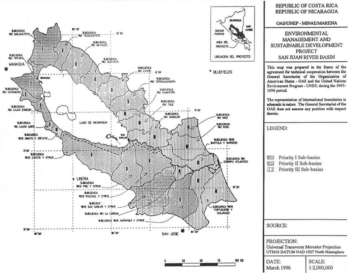
Also included is MAP N° 4, which shows the zoning by hydrographic sub-basins and the intervention priorities.
TABLE N° 5 INTERVENTION PRIORITY BY SECTOR
|
Country/Political-Administrative Division |
SECTORS |
General Priority |
|||
|
Agricultural |
Biodiversity |
Forest |
Social |
||
|
Costa Rica |
|
|
|
|
|
|
Pococí |
III |
I |
I |
II |
I |
|
Upalá |
II |
II |
I |
II |
II |
|
La Cruz |
1 |
I |
III |
III |
III |
|
Los Chile |
1 |
III |
III |
I |
III |
|
Sarapiquí |
III |
I |
I |
III |
III |
|
San Carlos |
I |
III |
II |
III |
IV |
|
Guatuso |
II |
II |
III |
III |
V |
|
Nicaragua |
|
|
|
|
|
|
Granada |
III |
II |
I |
III |
I |
|
San Juan |
III |
I |
I |
II |
I |
|
Rivas |
III |
II |
I |
III |
IV |
|
Chontales |
I |
III |
II |
III |
IV |
|
Boaco |
II |
III |
II |
III |
VI |
|
Masaya |
III |
II |
III |
I |
VI |
MAP No. 4. PRELIMINARY ZONING IN ACCORDANCE WITH WATER INDICATORS PER UNIT OF BASIN
![]()
![]()
![]()
![]()