![]()
![]()
![]()
![]()
![]()
A. TERMS AND CONCEPTS USED IN DESERTIFICATION HAZARD ANALYSIS
B. PRINCIPAL FACTORS WHICH INFLUENCE DESERTIFICATION HAZARDS
C. EVALUATION OF DESERTIFICATION HAZARD IN REGIONAL PLANNING STUDIES
REFERENCES
APPENDIX
![]()
|
SUMMARY Planners are presented with (1) terms, concepts, and important considerations related to an analysis of desertification potential in the region being studied; (2) the critical issues that need to be addressed in integrating analysis of desertification potential into the development planning process; (3) a decision tree to help the planner decide whether or not technical assistance will be needed for further work in this analysis; (4) guidelines for adapting the available decision tree data to map relative susceptibility to desertification; and (5) integrated terms of reference for the various sectors that will play a role in the analysis. |
This chapter provides planners with a method that will help them to identify areas where desertification has already started or where there is potential danger if suitable land-use practices are not followed, and thus to avoid making recommendations which may initiate or worsen the phenomenon.
Desertification became a media event before it had a definition, and supposed methods for its control were described well before it was understood as a process susceptible to practical human response. As a consequence, the popular literature is filled with misinformation, myth, and exaggeration, and the suggested "cures" often intensify rather than mitigate the phenomenon. Still, as a process, it can be as much man-caused as natural and therefore is one of the natural hazards best suited for mitigation by those who plan, implement, and manage regional development efforts.
Defining desertification has been a continuing problem. According to the United Nations Conference on Desertification (UNCOD, 1977), it is "the reduction or destruction of the biological potential of the earth which can create the conditions analogous to a natural desert." In different areas and among different peoples, it may mean (1) degradation of grazing lands, (2) destruction of vegetative cover, (3) wind erosion and moving sand dunes, (4) turning productive land into a "wasteland," and (5) degradation of vegetation and soil (Dregne, 1983). Mabbutt (1977) refers to the spread of desert conditions beyond desert margins and the intensification of desert conditions within desert boundaries. The definition used by Dregne himself (1983) comprises the impoverishment of terrestrial ecosystems under the impact of man, ecosystem deterioration measured by reduced size of crops, undesirable alterations in the biomass and the diversity of fauna and flora, and increased hazards for human occupancy. Thus, it is felt that desertification is a process of "resource degradation," though its perceived causes can cover a wide variety of activities including road building, industrial construction, geological surveys, ore mining, settlement construction, irrigation, motor transport, overgrazing, deforestation, expansion of intensive cash cropping, poor management of well water bore holes, and land settlement by previously nomadic people.
The above meanings tend to describe desertification on the basis of cause or secondary effects (generally loss of biomass production). Here, however, desertification will be looked at through the phenomena of waterlogging, salinization, increased soil temperature and aridity, increased dune formation, decreased soil organic matter, and increased albedo. Obviously, not all of these occur at one time on the same site; there are many different kinds of deserts. Nevertheless, common to all is the eventual decrease in total biomass production and an increase in noxious or unwanted flora and fauna. Obviously, without radial measures, many development objectives will be difficult to reach.
Desertification in South America affects 56 percent of the arid lands to a moderate degree and 22 percent to a severe degree (Dregne, 1983). Several million people live in these areas of degraded soils which, if not properly managed, could worsen. Of the 28.5 million inhabitants of dry lands in South America and Mexico, 4 million live on range lands, 22 million in areas where dry-land agriculture is performed, and 2.5 million in areas under irrigation. Thus, different geographic regions suffer to a greater or lesser degree from loss of productive soil to salinization; water and wind erosion; creation and movement of dunes; waterlogging; loss of surface and subsurface water in quality and quantity; and rapid depletion of vegetation cover. Population growth pressure may increase the degree of desertification if land-use practices are not modified. But much of it is the result of climatic conditions (high rates of evapotranspiration, scarce and erratic rainfall, and recurring drought) and inherent physical characteristics of the area (extremely permeable or impermeable soils and high water tables).
The idiom of desertification specialists draws from subjects like agriculture, forestry, geomorphology, hydrology, economics, physics, chemistry, sociology, and anthropology. Few people are experts in all these fields, but the planner working in arid and semi-arid areas should be acquainted with the more common "specialized" terms. This section introduces some terms and concepts used in discussions of desertification.
- Albedo: The ratio of light reflected from an unpolished surface to the total light falling on it. Albedo is important in calculating potential evapotranspiration (see below) using the heat budget method of determining evaporation. Different types of vegetation and different soils absorb different amounts of solar radiation, and their potential evapotranspiration will also be different. More solar radiation is reflected and less remains for heating and evaporation as surface albedo increases.
- Alkali Soils: Soils with few free salts but with enough sodium (Na) or potassium (K) to be injurious to most plants. The colloids of these soils deflocculate so that drainage and aeration are poor. The clay washes downward and accumulates as a hard pan below the surface. High Na can raise the pH above 8.5. Hydrolysis to NaOH is highly corrosive to humus, roots, and other living tissue.
- Animal Unit: A measure used to convert numbers of the various kinds of livestock to a common standard in relation to forage resources on the equivalent of a mature cow (live weight of about 450 kilograms). One animal unit equals about one head of cattle, one horse, one mule, five sheep, five swine, or five goats.
- Arid Zone: An area having a low ratio of precipitation to potential evapotranspiration (P/PET = 0.03 to 0.20). As a result, arid zones are regions of low biotic productivity. Arid zones are areas of dry land with both annual and perennial species. In their natural form they generally can sustain extensive livestock grazing but no dry-land agriculture.
- Carrying Capacity: (a) the number of individuals of a given species that can be sustained by a given ecosystem; (b) the density of people at a given standard of living that can be supported by a system; and, (c) the maximum number of a wildlife species which a certain territory will support through the most critical period of the year in terms of forage. People use information and technology to raise the natural carrying capacity of their environment by supplementing local ecosystems through the importation of energy and resources. This allows more people to occupy the land with a higher standard of living than would be achieved with the local natural environment alone.
- Desert: The term "desert" has never been precisely defined. In popular thinking, it generally means a region where vegetation is scarce or absent because of deficient precipitation or edaphic aridity but may also mean "wasteland" and areas of low production of vegetation regardless of the reason.
- Desertification Indicator: A physical phenomenon, an organism, a biotic community, a social criterion, or a combination of these, that is generally associated with one or more conditions that demonstrate the existence of the desertification process (Reining, 1978; Dregne, 1983).
- Desert Pavement: In desert areas, a layer of small stones, pebbles, or gravel covering on the surface of the soil which remains after wind erosion has removed the finer material.
- Drought: An extended period of dryness; usually any period of moisture deficiency that is below normal for a specific area. Sharing this commonality, there are several definitions which tend to be conceptual or operational and vary by discipline (meteorological drought, agricultural drought, hydrological drought, socio-economic drought) and by country (Whilhite and Glantz, 1987).
- Ecosystem: Any area having living organisms and inanimate substances acting as a unit and where material is interchanged among the living and inanimate elements and a flow of energy is developed within and through the system. Though ecosystems can be extremely small, the word is used in this chapter to mean an area the size of a small farm (1-5 hectares) to a region (several thousands of square kilometers). Ecosystem boundaries are set arbitrarily and are determined by the study objectives.
Figure 9-1 HOLDRIDGE LIFE ZONE CLASSIFICATION
Source: Holdridge, L.R. Life Zone Ecology (San Jose, Costa Rica: Tropical Science Center, 1967).
- Ephemeral: Indicates short-lived existence, in this case plants which have genetic adaptations that allow them to germinate, grow, and reproduce in a few weeks and can thus "take advantage" of certain short-lived environmental factors (soil moisture, temperature, access to nutrients) required for completing their life cycle.
- Evapotranspiration (ET): Total water lost from the land and water bodies by evaporation and plant transpiration. Evaporation from soils, plant surfaces, and water bodies, and transpiration through plant stomata collectively constitute evapotranspiration. The evaporation process is simply the net loss of water from a surface by means of a change in state of water from liquid to vapor. The requirements for evaporation or transpiration are: a) a flow of energy to the evaporating or transpiring surface; b) a flow of vapor away from these surfaces; and c) a flow of liquid water to these surfaces.
- Halophyte: A plant growing in saline soils; a salt-tolerant plant. Some species such as alfalfa are classified as halophytes although the term generally means plants that are native to saline habitats. Different species of halophytes tolerate different degrees of salinity.
- Humid Zone: An area having a precipitation to potential evapotranspiration ratio of greater than 0.75 (P/PET>0.75). That is, it is an area having excess water where drought conditions rarely occur. Forests occur and crops may be grown without irrigation in this zone (temperature permitting), although at the lower end of the precipitation range, production may be reduced.
- Hyper-Arid Zone: An area of extreme aridity having a precipitation to potential evapotranspiration ratio of less than 0.03 (P/PET<0.03) and where periods (even years) may go by with no precipitation. Except for phreatophytes, no permanent vegetation is present, although ephemeral plants occur with precipitation. Except in rare periods of precipitation when ephemerals may be grazed, no agriculture, forestry, or grazing is possible without some kind of irrigation.
- Life Zone: An altitudinal or latitudinal bioregion with distinctive faunal and floral characteristics. These are areas of natural landscape that are homogeneous in terms of climate. In Latin America and to some degree in the Caribbean, life zone maps have been developed based on the Holdridge system. These are areas having equivalently weighted divisions of heat, precipitation, and moisture. Heat is expressed as biotemperature, which is a measurement of the heat effective in plant growth (0-30 degrees Celsius); precipitation is total annual precipitation; and effective moisture is a combination of biotemperature and precipitation. All major life zones can be given a graphical representation (See Figure 9-1).
- Phreatophyte: A plant that absorbs its water from a permanent supply in the ground. These can be found growing along the edges of watercourses where there is a permanent flow of surface or ground water and in areas where the water table is generally near the surface.
- Population Pressure: Human, wildlife, and livestock population densities related to the various carrying capacities of an ecosystem. Also included are the relative pressures of cropping and irrigation on lands subject to salinization. Without irrigation, maximum limits in arid zones are thought to be seven inhabitants per square kilometer and one animal unit per five hectares and in the semi-arid zones 20 inhabitants per square kilometer and one animal unit per hectare.
- Potential Evapotranspiration (PET): Generally defined as the rate of evaporation and transpiration which would take place from a completely vegetated area in which soil water was not limiting. Maximum evaporation rates from large water bodies in arid areas approach 2500 mm per year.
- Precipitation (P): All types of moisture discharged from the atmosphere (rain, snow, hail, sleet, and measurable mist or fog).
- Range Condition: The status of rangeland vegetation in relation to its potential in terms of the amount and kind of biomass production. Evaluation of range condition involves an analysis of density and composition of plant species of "quality" (those that are palatable and which are preferred by livestock or wildlife) as opposed to those that are less palatable and which increase in density and composition under excessive grazing pressure, and those that are unpalatable and perhaps noxious and which invade the range under extremely heavy use by livestock.
- Range Trend: Evidence of change in the vegetation. For example, the species and vigor of any seedlings which, in the terminology of range management, can be called decreases, increases, or invaders, depending on their behavioral characteristics under grazing pressure, are important indicators of trend. Likewise, evidence of new or increasing erosion of eroded areas, as opposed to healing, and of trampling is also important. Since range trend is of interest primarily to the livestock manager, an increase in woody vegetation usually indicates a downward trend. In terms of desertification, however, an increase of woody vegetation could indicate a favorable trend.
- Saline-Alkaline Soils: Soils that combine the problems of both saline soils and alkaline soils in that they have a great deal of sodium (Na), are deflocculate, and usually have a pH above 8.5.
- Semi-arid Zone: An area having a ratio of precipitation to potential evapotranspiration of from 0.20 to 0.50 (P/PET = 0.20-0.50) and a natural discontinuous herbaceous vegetative cover with a greater frequency of perennial species than arid zones. This zone normally can sustain dry-land agriculture and livestock raising activities with little additional input if stocking rates are held at adequate levels to sustain production.
- Soil Texture: The relative proportions of the various sizes of mineral particles (gravel, sand, silt, clay) in the soil. Fine and coarse particles have very different properties in terms of water infiltration and holding capacity, compactability, erosivity, and nutrient availability. Textural classes range from clay consisting of particles smaller than 0.002mm in diameter (the material passes a sieve of 0.002mm), to silt (which passes a sieve between 0.002mm and 0.050mm), to fine sand (which passes a sieve between 0.050mm and 0.020mm), to coarse sand (which passes a sieve between 0.020mm and 0.200mm), to fine gravel (which passes through a mesh between 0.200mm and 2.00mm) and coarse gravel (which passes through a mesh between 2.00mm and 5.0mm). In general, the terms "fine texture" and "heavy texture" refer to soils containing large quantities of clay or clay loams while "coarse texture" and "light texture" refer to soils with relatively more sand than clay.
- Sub-humid zone: An area having a ratio of precipitation to potential evapotranspiration of 0.5 to 0.75 (P/PET = 0.5-0.75) covered with stands of natural vegetation that are more dense but which may include tropical savannas. Dry-land agriculture is common in this zone for crops adapted to occasional drought.
- Succession: A process of change in ecosystems from "immature" to "mature" stages. The earlier stages are characterized by greater net primary production and less species diversity. Maintenance of the earlier stages can be difficult and costly but any excess production can be harvested as food and fiber.
- Xerophytic Vegetation: Vegetation, especially woody vegetation, in dry climates. These plants tend to grow in stands having low densities. They grow slowly and have leaf structure and biochemical characteristics that permit great efficiency in water use.
![]()
1. Precipitation and the Occurrence of Drought
2. Potential Evapotranspiration (PET)
3. Wind
4. Soil Texture
5. Land Form
6. Land Use
7. Land Management
![]()
This section describes several of the factors affecting the processes of desertification. These, of course, depend on the great variety of physical (including climatic) and land-use characteristics of an area. Only those physical characteristics that can be easily measured or calculated, and which do not vary greatly with different land-use practices are considered to be principal factors; they are precipitation, potential evapotranspiration, soil texture, land form, and wind. These will be utilized to describe the methods for evaluating desertification in the early stages of development planning discussed later in the chapter. Because man can cause, intensify, or ameliorate the processes of desertification through the activities of the yearly agricultural cycle, it is important to know how these activities respond to the principal physical factors. Land use and land management are described in this section, as well as other factors such as ground and surface water levels. The occurrence of soluble salts and saline conditions in the substrate, soil structure, soil nutrients, and existence and movement of herbivores, including insect fauna, are also very influential in desertification. These, however, can rapidly change under conditions of use. As a consequence, they are not used here as primary determining factors when working at desertification potential.
Data on annual precipitation levels are generally available although monthly figures are often scarce. In cases where data are missing, annual and seasonal amounts may be estimated from the observation of the types and densities of the native undisturbed vegetation. Precipitation levels may be estimated, for example, from life zone maps developed with the Holdridge life zone system (See Figure 9-2). Information concerning historical annual variation of precipitation will be needed in order to gain an insight into drought occurrence. If climatic station data are not available, secondary information may be obtained from written and spoken historical records, geomorphological studies, as well as analysis of growth rings in woody vegetation.
Figure 9-2 RELATIONSHIP BETWEEN PRECIPITATION AND DOMINANT VEGETATION
|
Precipitation |
Dominant Vegetation |
|
0-25.4 cm/yr. |
Desert |
|
25.4 cm-76.2 cm/yr. |
Grassland, Savanna, Open Woodland |
|
76.2 cm-127.0 cm/yr. |
Dry Forest |
|
> 127.0 cm/yr. |
Wet Forest |
Source: Adapted from Odum, E.P. Ecology (New York: Holt, Rinehart and Winston, 1963).
In this primer precipitation levels greater than 1500mm/year are considered to be too humid for most forms of desertification. Thus, if the study area's precipitation level is below 1500mm/year, the methods discussed here may help in the planning process.
Several different types of storms are important in the analysis of desertification hazard. Cyclonic or frontal storms are long-lived and move almost continuously in definite routes across a continent. In areas where most of this type of precipitation exists, long periods of drought can occur. Orographic precipitation is caused by rising air currents that travel over land mass at high enough altitude that expansion and cooling of the air mass causes moisture condensation. As the air mass descends after crossing a higher elevation, it is warmed and the available moisture is tightly held. This creates arid conditions on the lee side of the elevated areas. Such is the case in much of Central America, where air movement from the Caribbean Sea contributes to the formation of cloud forests on mountain peaks but extremely arid conditions at lower elevations on the western side of the range (Figure 9-3). Convective precipitation occurs in hot months when the land surface becomes heated under strong insolation which then heats the lower strata of the atmosphere causing them to rise to strata of cooler temperature. Condensation causes rains, which tend to be heavy, of short duration, local in distribution, and accompanied by lightning. These storms are often accompanied by strong winds, and, at times, only the winds occur with little or no precipitation, causing intense dust storms. Because of both orographic and connective precipitation, rainfall maps made at stations a few miles distant in mountainous country may be subject to considerable error.
The concept of potential evapotranspiration is defined as an estimation of evaporation and transpiration rates if soil water is not limited. It compensates quite easily for the lack of information on transpiration and allows a clear synthesis of the numerous measurements of soil moisture, infiltration, runoff, etc., that are needed to understand climatic parameters. Evapotranspiration rates are related to several climatic factors, the most important one being temperature. For example, adjusting temperature figures for variations in day length (hours of daylight) using a formula developed by Penman (Chow, 1964) demonstrates that there is a close relationship between mean temperature and potential evapotranspiration. Consequently, this formula may be used to compute potential evapotranspiration for any place whose latitude is known and where temperature records are available or can be estimated. Data on water surplus and deficit can be inferred by comparing monthly precipitation and monthly potential evapotranspiration figures.
Evaporation rates can be obtained from readings on controlled bodies of open water (evaporation pans). Although transpiration is a product of evaporation from leaf surfaces, its rates depend on the availability of soil water as well as the structural and functional features of the plant (location of stomata and the internal processes governing loss and gain of water in the guard cells) as these are influenced by light. For example, light increases transpiration rates more than it does evaporation rates. On the other hand, wind increases evaporation rates more than it increases transpiration rates. Thus, evaporation rates do not always indicate transpiration rates.
Figure 9-3 - REPRESENTATION OF CENTRAL AMERICAN TOPOGRAPHY WHICH IS RESPONSIBLE FOR THE OROGRAPHIC PHENOMENON THAT CAUSES CLOUD FORESTS IN CLOSE PROXIMITY TO ARID AREAS

Legend:
1. Subtropical desert scrab
2. Subtropical thorn woodland
3. Subtropical dry forest
5. Pre montane moist forest
6. Montane wet forest
7. Montane rain forest (cloud forest)
8. Tropical moist forest
Wind is a climatic factor that can intensify desertification in many ways. Its force can erode, transport, and deposit soil particles. Damage to plants can occur either through the impact of its physical force when velocities are high or through the impact of transported abrasive soil and salt particles (sand blasting). In dry areas where soil is not held in place by vegetation, wind is a major factor in the formation of dunes. In the formation process of these dunes the wind, due to its velocity, leaves coarser material behind and continues transporting the finer soil particles. Although dunes can exist in non-desertification environments like coastlines or close to loosely cemented sandstones, their movement towards the outside limits of deserts is a clear indicator that desertification is taking place.
Wind increases water evaporation rates from land and plant surfaces. This evaporative power of moving air increases with higher temperatures and decreased relative humidity. As a result, hot dry winds during a plant's growth period can increase the amount of water it uses.
Although wind is a part of the climate and is much more regional in scope, wind patterns can change drastically under the influence of man's activities through the removal or addition of vegetation-especially woody vegetation-which acts as a barrier, provides shade, and decreases albedo.
Soil texture can influence many other soil characteristics, especially those concerned with soil moisture (Figure 9-4) and soil fertility. Sandy soils that are irrigated require relatively more water than finer textured soils but an excess of water may leach away any available colloids and nutrients. On the other hand, because precipitation penetrates almost immediately on coarse-textured soils, runoff is reduced to almost nothing. Fine-textured soils may hold more water than coarse-textured soils but in general: (a) they hold it in the upper soil layers where drying is greater; (b) there is greater water loss due to lower rates of infiltration and higher rates of overland flow or runoff; (c) they restrict root growth and seedlings, which may sprout on such soils and die before reaching the moisture held at deeper soil levels; (d) they are responsible for shallow root growth, which makes the plant susceptible to drought; and (e) they are less susceptible to gully and sheet erosion.
Two land form characteristics are of interest to this discussion of desertification: (a) degree or steepness of slope and (b) depth from soil surface to the water table.
Steepness of slope is important because it influences the velocity and the amount of surface water flow. Runoff, of course, is greater if the hillside slope is steeper. Slope steepness also influences amount and intensity of sunlight that a particular site receives. Desiccation, or drying, is greater if the slope faces the sun for longer periods of time and increases further if the slope angle is perpendicular to the sun's rays. Due to the erosion agent running water, particles are carried to flatter areas or areas of depression. Thus, soils tend to be shallower and of coarser texture near the top of a hill and are relatively deeper and finer textured at the foot of a slope. Desiccation is less severe in areas that face the sun less often and are therefore largely in shadow, again depending on the steepness of the slope. Desiccation is also lower in areas with leeward positions that are protected by intervening lands of higher elevations. If such elevations are high enough and abrupt enough, a rain-shadow effect could be established that would cause a decrease in overall precipitation (Figure 9-3).
Depth to ground water is important because if the water table lies too deep, the plant roots will not be able to obtain the available moisture. On the other hand, if the water table is too close to the surface, waterlogging will become a problem. And, in these areas, saline and alkaline conditions can kill vegetation or decrease their growth rates.
How a landscape is used can initiate the process of desertification. Certain kinds of agricultural practices, overgrazing by livestock and wildlife, extractive forestry, construction activities, and the use of fire are often considered the important contributors to the process.
Dry-land agricultural practices can contribute to the process because they expose soil to wind and water erosion during periods of early planting and after harvest. The finer soil particles are blown or washed away with the essential organic matter that will be missed in the following agricultural cycle. Thus, a gradual reduction of nutrients occurs through the years.
Figure 9-4 RELATIONSHIPS BETWEEN SOIL TYPE AND SOIL MOISTURE CONSTANTS (PERCENTAGES)
|
Moisture Constant |
Clay |
Loam |
Silt |
Sandy loam |
Fine sand |
|
Moisture equivalent |
28.4 |
21.7 |
16.1 |
9.5 |
3.2 |
|
Permanent wilting point |
13.4 |
10.3 |
7.5 |
2.9 |
1.0 |
|
Ground-water storage capacity |
15.0 |
11.4 |
8.6 |
6.6 |
2.2 |
Source: Daubenmire, R.F. Plants and Environment, 2nd ed. (New York: John Wiley and Sons, 1964).
Irrigated agriculture also may contribute to desertification if it is responsible for waterlogging and salinization. Waterlogging reduces soil aeration and the plant roots are unable to survive in this soil. This condition worsens the closer the water table is to the surface. Salinization or alkalization of lowland areas occurs when excess irrigation induces accumulation of soluble salts, which also impairs plant growth.
Grazing by domestic livestock, feral or exotic animals, and both large and small game animals, if poorly managed, contributes to loss of vegetative cover for the soil. In some ecosystems overgrazing promotes invasion by woody plant species that the grazing animals find unpalatable. Thus, the biomass level increases with a less desirable mixture of plant species. Competition for available soil water between the plants combined with the continuing overuse of the palatable species by the grazing animals can cause the rangeland to deteriorate further in terms of its production of fodder and animals.
Cutting of firewood for both domestic and industrial purposes likewise can contribute to desertification. Firewood collection, and charcoal production, normally become significant in areas near population centers where this is the cheapest or only source of energy. In other areas the collection of firewood on recently logged or burned sites is of secondary importance. Collection for industrial purposes can rapidly and significantly reduce vegetative cover since the demand is high and the gatherer obtains income from collecting wood.
Like agriculture, construction of buildings, reservoirs, roads, etc., and indiscriminate use of fire also remove the vegetative cover and leaves the soil unprotected and susceptible to erosion. Activities such as these, which change the normal drainage patterns, can be responsible for the erosion of extremely large amounts of soil. Almost any disturbance of stable soil surfaces such as desert pavement can initiate a new cycle of wind and water erosion.
The consequences of land management practices can be positive or negative. It is estimated that 23 million metric tons of wheat production a year are lost throughout the world to desertification (Dregne, 1983). Through proper agricultural, forestry, and rangeland management techniques many of these losses can be minimized. Enriching soils whose nutrients have been lost is costly and can be prevented.
Management of land, however, involves much more than land itself, and must consider other physical, biotic, social, economic, and cultural attributes. In many parts of the world these attributes lead to an annual cycle of events that represent what can be called, in a rural context at least, the agricultural year. In such areas, a year can be divided into distinct periods that depend on the number of crop cycles that can be grown in one year's time. This number is related to the length of the growing season, which may be dictated by temperature and day length-photoperiod-and by how precipitation is distributed over the year. All of these factors, of course, influence plant growth, flowering, and seeding and thus dictate the kinds and timing of activities that a farmer, forester, or livestock producer will undertake during the year.
In temperate climates there are generally four distinct periods which dictate the agricultural year. Given adequate and evenly distributed precipitation, the agricultural year follows this cycle: spring for land preparation and planting; summer for growth of the crop and the activities of cultivation (weeding, fertilizing, etc.); fall for the activities of harvest; and winter for fallow. These will vary greatly as one moves toward more tropical climates, where more than one crop cycle may be possible, sometimes with almost no fallow period. It also varies as one moves toward more arid climates, where irrigation may be necessary to replace natural supplies of moisture or where the fallow period may be quite lengthy because of the lack of precipitation.
Over time, a cycle of activities evolves that fits the climatic pattern for a given site. Problems arise when drought throws the cycle out of phase and wind or heavy rain occurs when the vegetative ground cover has been removed or disturbed. Problems also occur in areas that have been recently opened to cultivation, and where a proper crop/climate fit has not been developed; or where new crops have been introduced that do not quite match the peculiarities of a local climate. The problem of soil erosion arises when land lies in a state of preparation or uncovered fallow during periods of wind and heavy rain or if droughts follow land preparation and seeding.
Management of livestock, especially ruminants, must also fit the local climatic and biotic cycles. Heavy grazing in spring, for example, when grass is young and the ground is wet, can cause problems of trampling and soil compaction, while excessive grazing pressure during periods of drought can uproot plants and place even more stress on vegetation that is struggling to survive and reproduce.
Many other variations and combinations occur in the myriad climates that exist in arid and semi-arid zones regardless of whether they are tropical or temperate. The activities of agriculture and livestock management should be matched against the agricultural year to evaluate if moisture deficits, wind, and bare surfaces occur and if they occur together.
![]()
1. The Stages of Planning
2. Defining Desertification Potential
3. Integrated Analysis of Desertification Hazards
![]()
Integrated regional development planning studies can be prepared for physically defined river basins as well as for areas that are best defined geopolitically. In such regions, the moisture available to support life and human activities varies (OAS, 1984). As discussed in Chapter 1, a planning process that leads to integrated development of a region can be divided into four stages, each requiring more detail on more specific topics of concern and interest. Each stage requires distinct kinds and levels of information to help understand and consider the degree of desertification hazard (Figure 9-5). The methods proposed here are designed to fit these stages. And, as in planning in general, more detailed information will be required on fewer subjects in each succeeding stage.
![]()
a. Preliminary Mission
b. Phase I. Diagnosis of the Study Area
c. Phase II. Formulation of Development Projects
![]()
Evaluation of desertification hazards is undertaken during all planning stages: Preliminary Mission; diagnosis of the region and project identification (Phase I); action plan and project formulation (Phase II); and program implementation. Planning should include projects to reduce desertification hazards as well as to monitor effects that projects may have on the desertification process. To carry out such evaluations, basic information on natural resources and socio-economic characteristics will be necessary. This information will help in making decisions on the work required to evaluate and manage desertification hazards later on. A major task of the Preliminary Mission and Phase I (see Chapter 1) is to identify the sources and availability of such information.
The Preliminary Mission is the first response to an invitation of a government to undertake a planning study on its behalf. Typically a preliminary mission includes three professional disciplines: economics, natural resources development, and regional planning. Although each of these should look at the status of, or the potential for, the desertification process in the region, the professional in natural resources management takes primary responsibility for the subject.
An assessment as to whether any of the region under study has the potential for suffering the process of desertification can be made using any one of a number of world or regional maps available in moderately sized libraries holding information on natural resources. The "World Map of Desertification" (1:25,000,000) which was developed for the United Nations Conference on Desertification (FAO, 1977) is an example. Another useful map is the one prepared by Dregne in 1983 (Figure 9-6). Figure 9-7 has been adapted from this map and identifies the potential areas for desertification in the countries of South America.
Holdridge life zone maps, which are available for virtually all Central and South American countries, may also be used. In the Holdridge (1967) system, the dry tundra, dry scrub, steppe, dry forest, desert scrub, thorn steppe, thorn woodland, very dry forest, or desert life zones indicate areas of potential desertification. If any part of the area under study is in any of these life zones further desertification hazard analyses should be undertaken. A simplified method for identifying the various kinds of desertification hazard is given below (see Section C.2 Defining Desertification Potential).
Figure 9-5 - FLOW CHART RELATING INFORMATION NEEDS ON DESERTIFICATION HAZARD EVALUATION TO THE STAGES OF THE INTEGRATED DEVELOPMENT PLANNING PROCESS
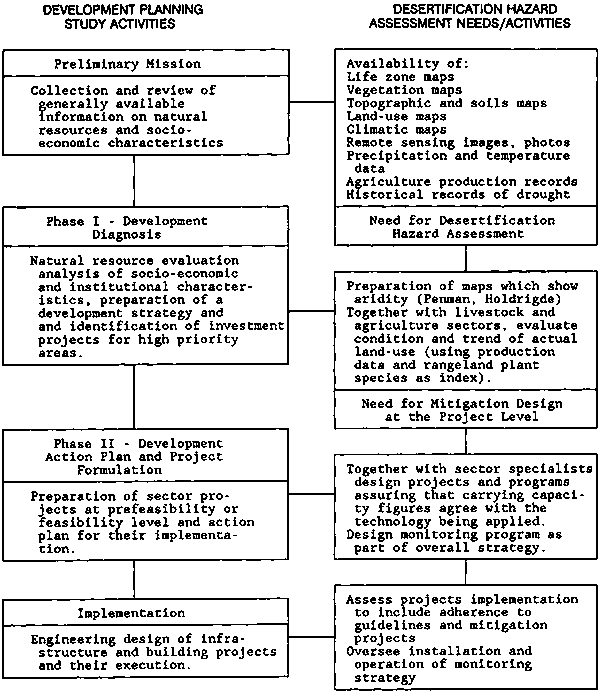
Figure 9-6 MAP SHOWING AREAS OF POTENTIAL DESERTIFICATION IN SOUTH AMERICA
Source: Adapted from Dregne, H.E. Desertification of Arid Lands, Vol. 3 of Advances in Desert and Arid Land Technology and Development (Chur, Switzerland: Harwood Academic Publishers, 1983).
Figure 9-7 - AREAS OF POTENTIAL DESERTIFICATION IN SOUTH AMERICA BY STATE, PROVINCE, OR DEPARTMENT a/
|
COUNTRY |
Hyperarid Region |
STATUS OF DESERTIFICATION | |||
|
Slight |
Moderate |
Severe |
Very Severe |
||
|
ARGENTINA
|
|
Catamarca |
Chubut |
Catamarca |
La Pampa |
|
|
Chaco |
La Pampa |
Cordoba |
|
|
|
|
Chubut |
Mendoza |
Jujuy |
|
|
|
|
Formosa |
Neuquén |
La Pampa |
|
|
|
|
Jujuy |
Rio Negro |
La Rioja |
|
|
|
|
La Rioja |
|
Mendoza |
|
|
|
|
Mendoza |
|
Salta |
|
|
|
|
Neuquén |
|
San Juan |
|
|
|
|
Rio Negro |
|
San Luis |
|
|
|
|
Salta |
|
Santiago del Estero |
|
|
|
|
San Juan |
|
|
|
|
|
|
Santa Cruz |
|
|
|
|
|
|
Santiago del Estero |
|
|
|
|
|
BOLIVIA
|
|
Cochabamba |
|
Cochabamba |
|
|
|
Chuquisaca |
|
Chuquisaca |
|
|
|
|
La Paz |
|
La Paz |
|
|
|
|
Oruro |
|
Potosí |
|
|
|
|
Potosí |
|
Tarija |
|
|
|
|
Santa Cruz |
|
|
|
|
|
|
Tarija |
|
|
|
|
|
BRAZIL
|
|
|
Alagoas |
|
|
|
|
|
Bahía |
|
|
|
|
|
|
Ceará |
|
|
|
|
|
|
Paraíba |
|
|
|
|
|
|
Pernambuco |
|
|
|
|
|
|
Piauí |
|
|
|
|
|
|
Rio Grande do Norte |
|
|
|
|
|
|
Sergipe |
|
|
|
|
COLOMBIA
|
|
|
Atlántico |
|
|
|
|
|
Guajira |
|
|
|
|
|
|
Magdalena |
|
|
|
|
CHILE
|
Antofagasta |
Antofagasta |
Aconcagua |
Antofagasta |
|
|
Atacama |
Atacama |
Coquimbo |
Atacama |
|
|
|
Tarapacá |
Tarapacá |
Valparaíso |
|
|
|
|
ECUADOR
|
|
Esmeraldas |
|
|
|
|
|
Guayas |
|
|
|
|
|
|
Manabí |
|
|
|
|
|
MEXICO
|
Sonora |
Baja California Norte |
Baja California Norte |
Aguas Calientes |
Chihuahua |
|
|
|
|
Baja California Norte |
|
|
|
|
Baja California Sur |
Nuevo León |
Chihuahua |
|
|
|
|
|
Sinaloa |
Coahuila |
|
|
|
|
Sonora |
Sonora |
Durango |
|
|
|
|
|
|
Guanajuato |
|
|
|
|
|
|
Guerrero |
|
|
|
|
|
|
Hidalgo |
|
|
|
|
|
|
Michoacán |
|
|
|
|
|
|
Nuevo León |
|
|
|
|
|
|
Oaxaca |
|
|
|
|
|
|
Puebla |
|
|
|
|
|
|
Querétaro |
|
|
|
|
|
|
San Luis Potosi |
|
|
|
|
|
|
Sinaloa |
|
|
|
|
|
|
Sonora |
|
|
|
|
|
|
Tamaulipas |
|
|
|
|
|
|
Zacatecas |
|
|
|
PARAGUAY
|
|
Boquerón |
|
|
|
|
|
Chaco |
|
|
|
|
|
|
Nueva Asunción |
|
|
|
|
|
PERU
|
Ancash |
Ancash |
|
Arequipa |
|
|
Arequipa |
Arequipa |
|
Ayacucho |
|
|
|
Ica |
Ayacucho |
|
Moquegua |
|
|
|
La Libertad |
Cajamarca |
|
Puno |
|
|
|
Lima |
Huancavelica |
|
Tacna |
|
|
|
Moquegua |
Ica |
|
|
|
|
|
Tacna |
La Libertad |
|
|
|
|
|
|
Lambayeque |
|
|
|
|
|
|
Lima |
|
|
|
|
|
|
Moquegua |
|
|
|
|
|
|
Piura |
|
|
|
|
|
|
Puno |
|
|
|
|
|
|
Tacna |
|
|
|
|
|
|
Tumbes |
|
|
|
|
|
VENEZUELA
|
|
|
Falcón |
|
|
|
|
|
Zulia |
|
|
|
a/ Area is defined as the largest political subdivision of the country. The fact that an area appears with a specific status of desertification does not necessarily imply that the entire area is affected. Moreover, an area can have more than one status when different portions are affected to different degrees.Source: Adapted from: Dregne, H.E. Desertification of Arid Lands (Chur, Switzerland: Harwood Academic Publishers GmbH, 1983).
|
PRELIMINARY MISSION QUESTIONS PLANNERS NEED TO ASK: - Is the study area included in a previously defined desertification hazard map or potential desertification hazard map? - What basic resource information has been mapped (soils, geology, climate, vegetation, forests, life zones, topography)? - What is the availability of satellite imagery? At what scale? - Is information on hydrology available? Does basic climatic and hydrologic instrumentation exist in the region? - What other information is available describing the region from a systems point of view? What is the history of occurrence of hazardous events contributing to desertification? KEY DECISIONS TO BE MADE AT THIS STAGE: - Creation of a base map and compilation of relevant thematic maps at appropriate scales. |
If this preliminary analysis suggests that desertification is a present or potential problem in the study area, a more precisely defined objective to be met during the next stage of planning should be formulated. That is, an objective which specifically treats the problem of desertification should be made so that it can be treated in the overall regional plan. Terms of reference relevant to further study of the desertification hazard should be included for the work of the specialists assigned to the next stage of the study (see the Appendix to this chapter).
The member of the Preliminary Mission assigned to specifically evaluate desertification will need to answer the questions shown in the box above and to develop other information for an analysis of desertification hazard during subsequent stages.
The diagnosis phase of the study is designed to identify the principal problems, potentials, and constraints in the region being studied. It includes an evaluation of natural resources and socio-economic conditions; it delineates and studies subregions, generates new information on relevant subject areas, and identifies prospective development projects. Given the work of the earlier Preliminary Mission, all professionals on the study team should be aware of the potential for desertification and should include in their analyses an explicit concern for that potential.2/ The team's environmental management adviser or natural hazard specialist should take full responsibility in this study. If neither position exists, the responsibility should reside with the agriculture or livestock management specialists. Several questions and decisions need to be addressed (see box below) which will help guide the team members in evaluating the overall desertification hazard as well as in assessing individual types of the hazard that may exist in the study area.
The previous stage identified the pressing issues and formulated a general strategy together with project ideas that address the problems with the available resources. Actions will have been suggested that are politically feasible within a time frame short enough to maintain the momentum required for decision making.
This stage is to formulate specific development projects based on the overall strategy and project ideas that were designed during Phase I. For purposes of the control of desertification, existing natural and man-made services that control the desertification process as well as the hazardous events that contribute to its progress will have been looked into. Cultural, social, and economic factors that could influence project execution and success need to be assessed at the appropriate level of feasibility. And the compatibility of the projects themselves needs to be evaluated in terms of their potential for intensifying or mitigating the desertification process.
|
PHASE I QUESTIONS PLANNERS NEED TO ASK: - Can cause/effect relationships be shown between natural events, and between natural events and human activity, that have been responsible for desertification in the past? - What are the natural goods and services provided to local populations from the ecosystems and how are these divided into the systems that represent environmental units? - Who are the individuals at the local, regional, and national levels who are best informed about the structure and function of the regional and local ecosystems? - What are the important linkages between the region under study and the neighboring regions? - What is the distribution of desertification events according to subsystem? KEY DECISIONS TO BE MADE AT THIS STAGE: - Characteristics of any desertification abatement projects that should be considered. - Identification of any desertification abatement projects that are to be a part of on-going programs or a new development program. - Preparation of an integrated work plan that includes work on desertification specific for the next stage of the process. |
Specialists in any sector should evaluate potential projects that explicitly treat mitigation of the desertification process and some specialists such as those in agriculture, range management, and forestry should have experience studying and proposing projects and programs relevant to the desertification process.
![]()
a. Hazard Zoning
b. A Descriptive Key to Identify Desertification Potential
![]()
In this section short descriptions will be presented concerning two important aspects of the identification and evaluation of desertification potential: the zoning of hazard potential and the identification of the specific desertification hazards.
The study area in which the desertification hazard evaluation is to be carried out should be zoned according to as many of the major variables active in the desertification process as possible (see B above). Climate data are especially important and a number of conventional systems of climate zoning exist. Bailey (1980) suggests several such classifications depending on the level of mapping being considered. For example, the methods of Koppen, Kuchler, and Hammond can be used to divide the landscape into a series of ecosystem levels (Figure 9-8). The Holdridge life zone method uses measurements of mean annual "bio-temperature," potential evapotranspiration ratio, and average total annual precipitation to divide an area into life zones and has a number of advantages. First, it is based on biotemperature and moisture-both highly correlated with desertification. Second, it now includes data on slope, soil texture, and soil depth. And, third, maps at varying scales exist for most of Latin America and some of the Caribbean.
During the Preliminary Mission, the decisions depend on the existence of different desertification hazards. Such decisions deal with the selection of specialists for Phase I and with the development of their terms of reference.
Figure 9-8 LEVELS OF GENERALIZATION IN A HIERARCHY OF ECOSYSTEMS
|
Levels of Generalization and Common Scales of Mapping |
Current Definitions |
|
1. Domain |
|
|
1:3,000,000 and smaller (for use at Preliminary Mission level of planning) |
Subcontinental areas of broad climatic similarity identified by zonal heat and water balance criteria. |
|
2. Division |
|
|
1:1,000,000 to 1:3,000,000 (for use at Preliminary Mission level of planning) |
A part of a domain identified by macroclimatic criteria generally at the level of the basic climate types of Koppen. |
|
3. Province |
|
|
1:500,000 to 1:1,000,000 (for use in preliminary work during Phase I) |
A part of a division identified by bio-climate and soil criteria at the level of soil orders and classes of vegetation during formations. Highland regions (e.g., mountain systems) with complex climate-vegetation zonation are distinguished at this level. |
|
4. Section |
|
|
1:250,000 to 1:500,000 (for use in Phase I and early Phase II) |
A part of a province identified by a single climatic vegetation climax at the level of Kuchler's potential vegetation types. |
|
5. District |
|
|
1:150,000 to 1:250,000 (for use in Phase I and early Phase II) |
A part of a section identified by Hammond's land-surface form types. |
|
6. Landtype association |
|
|
1:20,000 to 1:125,000 (for use in Phase I and Phase II) |
A part of a district determined by isolating areas whose form expresses a climatic-geomorphic process (e.g., fluvial, glacial, etc.). |
|
7. Landtype |
|
|
1:10,000 to 1:20,000 (for use in Phase II and some design work) |
A part of a landtype association having a fairly uniform combination of soils (e.g. soil series) and a chronological sequence of vegetation at the level of Daubenmire's (1964) habitat types. |
|
8. Landtype phase |
|
|
1:2,500 to 1:10,000 (for use in Phase II and some design work) |
A part of a landtype based on variations of soil and landform properties such as soil drainage and slope that affect the productivity of the habitat type. |
|
9. Site |
|
|
1:2,500 and greater (for use in design work) |
A part of a landtype phase that is homogeneous in respect to all components, their appearance, potential to produce biomass, limitations to use, and response to management. It is the basic geographic cell of the ecological classification. |
Source: Modified from Bailey, R.G. "Integrated Approaches to Classifying Land as Ecosystems" Proceedings of the Workshop of Land Evaluation for Forestry (Wageningen, The Netherlands: International Institute for Land Reclamation and Improvement, 1980).
|
PHASE II QUESTIONS PLANNERS NEED TO ASK: - What are realistic levels of technology, credit, knowledge, information, market, etc., that will be available to the users of the land? - What are the projects and programs that are being discussed by the other team members that would intensify or mitigate the desertification process? - How can mitigation measures be designed to fit or even enhance these projects? KEY DECISIONS TO BE MADE AT THIS STAGE: - Make adjustments to current land use. - Recommend levels of technology, credit, market, information, etc. - Define the specific instruments of policy and management required for implementation of the overall strategy and individual projects. - Design projects needed to monitor implementation of the program in terms of desertification. |
Figure 9-9 is a descriptive key or modified decision tree designed to help gain information on the kind and degree of the desertification that may be encountered in regional development studies. The method is based on easily measurable or existing data that are not normally subject to change due to human activity; and it is totally objective from the point of view of the evaluator.
The method uses data from the region being studied and is based on an understanding of the regional system, including existing conditions and development activities, thus enabling one to identify which desertification hazards are present. With this information, actions may be designed at later stages that would evade and/or help ameliorate the desertification processes.
In the key (Figure 9-9), numbers in the right margin (2, 2*, 3, 3*, 4, 4*...15, 15*) indicate where to go in the key given the data at hand. The letters correspond to general descriptions of desertification potential and discussions of land use that may be related to the site being described.
Information derived from Figure 9-9 can help in choosing the specialists and developing the terms of reference for these Phase I specialists; and, depending on the scale, quality, and quantity of this information, it could be mapped to indicate the location of each different desertification hazard encountered in the study.
(a) Annual average precipitation > 1500mm; >50% sand; >10° slope:
An annual average precipitation of over 1500mm generally indicates a site situated in the wet forest life zone of the Holdridge (1967) classification system. In addition, however, the timing, duration, and intensity of each precipitation event as well as the characteristics of the soil, air temperatures, and topography can dictate the potential of a given site to suffer initiation of the desertification process. Consequently, even if annual precipitation is near 1500mm, its overall distribution should be evaluated, since marked wet and dry periods could indicate potential desertification problems in terms of soil loss, through erosion by water or wind. Soil erosion will also depend on the characteristics of land use and land-use management. That is, the lack of soil protection during the very wet or very dry parts of the year can increase soil loss and the use of soil conservation measures may help to control or ameliorate soil loss. Infrastructure such as buildings and other structures may be lost because of wind and water erosion or slope failure because of the high sand content of the soil and the relatively steep slopes. Waterlogging, however, should not be a problem because the high sand content of the soil and the relatively steep slopes provide more than adequate drainage.
Figure 9-9 DESCRIPTIVE KEY TO THE IDENTIFICATION OF DESERTIFICATION POTENTIAL
A dichotomous key is presented below in which several factors are identified which can influence the desertification process. In the key a decision is forced at each number that depends only on the value of the factor being considered. The numbers between 1 and 15 are given in pairs and one of each pair has an asterisk (*) which can also be chosen depending on the quantitative value of the factor being considered. Text corresponding to the letters of the alphabet discusses each individual site and its potential for suffering initiation of the desertification process.
|
IF: |
GO TO: |
||||
|
(1) Precip >1500mm/yr |
2 or 2* |
||||
|
|
(2) > 50% sand |
3 or 3* |
|||
|
|
(3) >10° slope |
(a) in the text. |
|||
|
|
(3*) <10° slope |
(b) in the text. |
|||
|
|
(2*) < 50% sand |
4 or 4* |
|||
|
|
(4)> 10° slope |
(c) in the text. |
|||
|
|
(4*) <10° slope |
(d) in the text. |
|||
|
(1*) Precip <1500mm/yr |
5 or 5* |
||||
|
|
(5) P/PET >1.0 |
6 or 6* |
|||
|
|
(6) >50% sand |
7 or 7* |
|||
|
|
(7) > 10° slope |
(e) in the text. |
|||
|
|
(7*) <10° slope |
(f) in the text. |
|||
|
|
(6*) <50% sand |
8 or 8* |
|||
|
|
(8) >10° slope |
(g) in the text. |
|||
|
|
(8*) <10° slope |
(h) in the text. |
|||
|
|
(5*) P/PET <1.0 |
9 or 9* |
|||
|
|
(9) P/PET .76-.99 |
10 or 10* |
|||
|
|
(10) >50% sand |
11 or 11* |
|||
|
|
(11) >10° slope |
(i) in the text. |
|||
|
|
(11*) <10° slope |
(j) in the text. |
|||
|
|
(10*) <50% sand |
12 or 12* |
|||
|
|
(12) >10° slope |
(k) in the text. |
|||
|
|
(12*) >10° slope |
(I) in the text. |
|||
|
|
(9*) P/PET .01-.75 |
13 or 13* |
|||
|
|
(13) >50% sand |
14 or 14* |
|||
|
|
(14) >10° slope |
(m) in the text. |
|||
|
|
(14*) < 10° slope |
(n) in the text. |
|||
|
|
(13*) <50% sand |
15 or 15* |
|||
|
|
(15) >10° slope |
(o) in the text. |
|||
|
|
(15)* <10° slope |
(p) in the text. |
|||
(b) Average annual precipitation > 1500mm; >50% sand; < 10° slope:
Native vegetation would again be classified as wet forest. Both agriculture and livestock ranching are often tried under these characteristics. These activities work best, if at all, at the drier end of the precipitation range. Given the low angle of slope, trampling by livestock could reduce infiltration rates-if the remaining soil fraction is clay-and problems similar to those of waterlogging are created. However, water erosion would be minimal because of the reduced slope, and where the soil is very sandy, waterlogging would not be a problem unless the area happened to be in a geographic depression with a high water table. Problems of salinity and alkalinity would generally be limited because of the high rainfall. Construction requires well engineered roads, bridges, and foundations because of erosion along river borders in areas of relatively flat terrain.
(c) Average annual precipitation > 1500mm; <50% sand; >10° slope:
Areas having these characteristics suffer the same potential hazards as the areas described in (a) with the slight difference that the lower sand content may reduce the potential for water erosion on the steeper slopes. Soils having a greater percentage of clay or loam contain more nutrients despite precipitation rates greater than 1500mm per year and, therefore, such areas generally have good vegetative cover in their natural state. Consequently, both conversion of the forest to pasture and pasture maintenance are difficult and expensive. And, under the kinds of grazing pressures required to keep down the woody vegetation, such areas suffer from trampling and the creation of terraces, or trails, by the livestock. This allows runoff to be concentrated and the trails then become susceptible to the formation of gullies. Soils in this group are a bit more stable than those having a higher percentage of sand, and buildings and other infrastructure would generally be at less risk to erosion and slope failure.
(d) Average annual precipitation > 1500mm; <50% sand; <10° slope:
Under these conditions the major desertification hazard is caused by waterlogging. The high precipitation, relatively heavier soils (soils having a higher percentage of clay), and less steep slopes all lead to excess water and waterlogging: more water, less runoff, and slower infiltration rates. A potential for waterlogging can be aggravated by certain land uses. Tree removal diminishes evapotranspiration; trampling by livestock increases bulk densities of the less sandy soil; and water collects in areas of little or no slope. In terms of infrastructure, any roads will require construction of a large number of culverts to allow free passage of runoff.
(e) Average annual precipitation < 1500mm; P/PET 1.0+; >50% sand; >10° slope:
The low rate of evapotranspiration compared to the amounts of precipitation that these areas receive indicates regions that have fairly low temperatures. Even if annual average precipitation is low, excess water may exist. The high sand fraction and steep slopes work against waterlogging. However, these same characteristics would promote water erosion. If, in the cooler areas, growing seasons are shortened, certain kinds of agriculture and ranching (heavy grazing, trampling, plowing, clean fallow, and some construction activities) would eliminate or reduce ground cover during certain parts of the year. If these periods coincide with seasons of wind, erosion, and the formation and movement of sand dunes can be expected.
(f) Average annual precipitation < 1500mm;
P/PET 1.0+; >50% sand; <10° slope:
Under these characteristics, there is limited potential for nearly all kinds of desertification-especially near the upper end of the precipitation range and at the higher P/PET ratios. Again, because of the high P/PET ratios, the general climate would be cool to cold and this would place the area at either high altitude or high latitude. The major desertification hazard would be wind causing erosion problems if the land is left unvegetated. Growing seasons would generally be short, and clean fallow would be more likely to coincide with periods of wind. Waterlogging could be a problem in the flatter areas having less sand content in the soil.
(g) Average annual precipitation < 1500mm;
P/PET 1.0+; <50% sand; >10° slope:
Despite the large variation in precipitation that could occur in these areas, the key to understanding desertification hazard here is the P/PET ratio above 1.0. A high ratio of precipitation to potential evapotranspiration would mean a surplus of water during parts of the year. If this excess water were allowed to run off slopes of greater than 10°, water erosion would occur and this would generally be intensified under land uses which disturb vegetative cover. The P/PET ratio again indicates a fairly cold climate and a short growing season. As a consequence, soils may remain uncovered for lengthy periods. Despite the excess water as indicated in the P/PET ratio, periods of seasonal drought can occur. Wind during such dry periods can cause erosion, the formation of sand dunes, and, in cases of high and sustained wind velocities, the movement of sand dunes. Agricultural and livestock management practices as well as the design, construction, and maintenance of infrastructure should be undertaken with this in mind.
(h) Average annual precipitation < 1500mm;
P/PET 1.0+; <50% sand; <10° slope:
The characteristics of these areas are similar to those described in (e), (f), and (g): cool or cold temperatures and location at high altitude, high latitude, or both. In Latin America parts of the very high Andes or far Southern Cone would correspond to these characteristics. Due to short growing seasons, and low temperatures, such areas have excess water despite low total precipitation figures. Waterlogging may, therefore, be a hazard on the flatter areas. Agriculture is difficult because of the short growing seasons although grazing of livestock may be possible. In some areas trampling by livestock could aggravate waterlogging problems. These areas also usually have high wind velocities during portions of the year. As a consequence, artificial protection of the soils may be necessary.
(i) Average annual precipitation < 1500mm;
P/PET = 0.76-0.99; >50% sand; > 10° slope:
Because of the potentially low precipitation, higher risk of drought, and lower P/PET ratios, these are the areas that are normally thought of in conjunction with the desertification process. Certain combinations of these characteristics (very low precipitation and P/PET ratio near .76) present conditions that are extremely favorable for initiation of the desertification process. This is especially a problem on steep slopes and sandy areas where water erosion can occur if vegetation is removed. In Latin America, large-scale clearing by fire or by bulldozer to create range-land for livestock grazing intensifies desertification hazards. Clearing of vegetation for rain-fed or irrigated agriculture, by heavy browsing and/or grazing by livestock, by the use of woody biomass for firewood and/or the production of charcoal, and by clearing for construction of infrastructure or housing are also causal factors. In Latin America, overgrazing by wildlife probably does not play a significant role except in isolated cases (vicuna or deer confined to publicly managed reserves or privately held protected areas). In areas receiving rainfall at the high end of the range and at high intensities, surface erosion is a potential threat. In the drier areas, a desertification threat may also be occasioned from wind.
(j) Average annual precipitation < 1500mm; P/PET =0.76-0.99; >50% sand; < 10° slope:
The significant difference between areas having these characteristics and the areas described in (i) above is the degree of slope. Consequently, areas falling within the previous description have problems of water and wind erosion and the areas described here have problems of surface salinity-particularity in areas having precipitation levels and P/PET ratios at the lower end of the stated ranges. Irrigation in poorly drained areas or poorly designed infrastructure such as roads, railroads, and dikes which inhibit the flow of water would worsen the salinity condition. Although surface salinity may be the major desertification hazard of concern here, subsurface soil salinity (caliche) could also be a problem if precipitation is at the higher end of the range and if the soils are heavy. These conditions allow leaching of salts from the upper soil levels but they also prohibit leaching from the total soil profile.
(k) Average annual precipitation < 1500mm; P/PET =0.76-0.99; < 50% sand; > 10° slope:
Areas having these characteristics are relatively free from desertification hazards although they may be arid or semi-arid. Under the lower rainfall conditions and the resulting scarcity of vegetation, intense precipitation events cause water erosion and such erosion is more severe if the soil surface is disturbed by trampling, plowing, fire, or soil movement for construction purposes. Likewise, if the soil is uncovered during periods of drought and wind, as it often is, erosion will occur.
(l) Average annual precipitation < 1500mm; P/PET = 0.76-0.99; <50% sand; < 10° slope:
Because of the low slope angle, desertification problems are, (1) wind erosion, depending on how the seasons of drought coincide with those of reduced vegetative cover because of human activities (farming practices) or low temperatures; and (2) salinity of soils in areas having less rainfall and greater potential evapotranspiration. If the soil clay fraction is high (as it often is due to deposition of the finer soil material on areas of little or no slope), puddling, soil expansion, and vertical soil movement decrease vegetative cover. Land use may include rain-fed agriculture in areas at the higher precipitation levels, although production is low and decreases with decreasing levels of precipitation and/or increasing rates of evapotranspiration. At the lower precipitation levels, then, irrigation would be necessary and this could increase the probability of salinization and waterlogging.
(m) Average annual precipitation < 1500mm; P/PET = 0.01-0.75; >50% sand; > 10° slope:
These characteristics describe areas having a high potential for desertification. Because of the low precipitation, high potential evapotranspiration, rapid infiltration beyond the root zone of any precipitation entering the soil, and even more rapid runoff of precipitation that stays on the surface because of the steep slopes, the desertification process is easily initiated in these areas. The amount of moisture available for biomass production is small. Wind and direct insolation reduce available moisture even further and these are influenced by human activity which disturbs ground cover, be it vegetation or erosion pavement. Disturbance of ground cover can also initiate the formation of blow-outs (areas excavated by the force of wind). Over-grazing, plowing, trampling, and clearing for construction can all initiate the process. Even irrigation is potentially harmful, 1) because of the amount of water that probably will be necessary and the salinity of its residues; and 2) because of the erosivity of the sandy soils on steep slopes even if modem irrigation technology is used. Furthermore, given the low precipitation totals and the sparse cover of the soils by vegetation, incoming radiation will often be high and cultural practices for crops, livestock, and construction will need to consider shade and insolation in project design. Slope angle and orientation are important in that slopes which face the sun will be much drier and warmer and, except in the very cold latitudes, will have much less vegetative growth.
(n) Average annual precipitation < 1500mm; P/PET = .01-.75; >50% sand; <10° slope:
Conditions in these areas are similar to those found in areas described in (m) above except that, here, slopes are much less steep. The landscape is generally less well defined geomorphically as well. As a consequence, these flatter areas may have a higher level of soil moisture because they receive runoff from the slopes above and because insolation will generally be less direct. Wind erosion and the formation of sand dunes could be a problem if the soil is without cover during the periods of wind and little or no precipitation. Soil salinity could be a problem, although the sandier soil allows rapid infiltration that would wash the salts to lower levels in the soil profile, where they will form a layer of calcite. In areas where vegetation or desert pavement is disturbed by agriculture, grazing pressure, or construction activities, wind can create blow-outs and these often increase in size unless remedial efforts are made to restore the ground cover. Gathering of woody vegetation for charcoal and/or firewood could also initiate a cycle of reduced effective surface moisture because of the higher insolation and albedo.
(o) Average annual precipitation < 1500mm; P/PET = 0.01-0.75; < 50% sand; > 10° slope:
The major difference in the characteristics of these areas from those described in (n) above is in the amount of sand in the soil. A smaller percentage of sand in a soil means that the percentages of clay and silt are higher. The clay and silt fractions contain more nutrients and this may be reflected in the amount of vegetation that is present. On the other hand, if the soils are predominantly clay, runoff of precipitation is increased due to low infiltration rates. As a consequence, the areas described here may be drier than those described in (n) above. Additionally, root penetration may be reduced because higher percentages of clay generally mean that the soil is much harder and less friable under dry conditions. In any case, effective moisture in these areas is low and human activity could reduce it even more through exposing the land surface to radiation (higher temperatures) and wind.
(p) Average annual precipitation < 1500mm; P/PET = 0.01-0.75; < 50% sand; < 10° slope:
The characteristics of this area are very similar to those presented in (o) above except that slope steepness is much less. This difference is significant in that higher salinity levels will be encountered in the soil, subsoil, and open water. Given the higher clay content and less steep slopes, high soil alkalinity levels may also be present and these should be considered when proposing more intensive land use, especially irrigated agriculture. Beyond this, the common problems of desertification are all a potential in these areas: waterlogging (with irrigation); water erosion (especially along the edges of intermittent water courses); wind erosion; dune formation and movement; and reduced effective moisture. All of these will negatively affect the production of biomass.
Desertification is a complex phenomenon requiring the expertise of specialists from several different disciplines if it is to be understood and managed. Climatology and meteorology, soils, agronomy, range management, anthropology, political science, and economics are all appropriate for undertaking a study of the desertification process, and input from these and others will be required if development planning is to adequately treat the subject.
To be useful, each specialist must look toward a common objective and the information obtained must be shared. As in any integrated study, the output from one discipline serves as input to another and the output of one stage of planning serves as input to the next planning stage (OAS, 1978, 1984).
Each planning stage will require information from the sectors which these specialists represent but the information must be progressively more detailed and more narrowly focused in each succeeding stage. The Preliminary Mission, of course, will not have individuals from all specialties. Rather, the individuals who make up the Preliminary Mission must account for this information. Phase I may well have specialists from each sector to gather and organize information required by the specialists who will compose the Phase II mission. These specialists would make use of the information in developing strategies, projects, and programs. Further on, much of this information will serve as base-line data for integrated monitoring programs. (See the chapter appendix for explicit terms of reference for the work of selected specialists in Phase I of the planning exercise.)
Bailey, R.G. "Integrated Approaches to Classifying Land as Ecosystems" in Proceedings of the Workshop of Land Evaluation for Forestry: (Wageningen, The Netherlands: International Institute for Land Reclamation and Improvement, 1980), pp. 95-109.
Chow, V.T. Handbook of Applied Hydrology (New York: McGraw-Hill, 1964).
Daubenmire, R.F. Plants and Environment, 2nd ed. (New York: John Wiley and Sons, 1964).
Dregne, H.E. Desertification of Arid Lands, Vol. 3 of Advances in Desert and Arid Land Technology and Development (Chur, Switzerland: Harwood Academic Publishers, 1983).
Food and Agriculture Organization (FAO). World Map of Desertification. Prepared for the United Nations Conference on Desertification, Nairobi, 1977 (Document A/CONF.74/2.FAO/WMO/UNEP, 1977).
Holdridge, L. Life Zone Ecology (San José, Costa Rica: Tropical Science Center, 1967).
Mabbutt, J.A. "Climatic and Ecological Aspects of Desertification" in Nature and Resources, vol. XIII, no. 2:3-9 (1967).
Organization of American States. Integrated Regional Development Planning: Guidelines and Case Studies from OAS Experience (Washington D.C.: Organization of American States, 1984).
- Environmental Quality and River Basin Development: A Model for Integrated Analysis and Planning (Washington D.C.: Organization of American States, 1978).
Odum, E.P. Ecology (New York: Holt, Rinehart and Winston, 1963).
Reining, P. Handbook of Desertification Indicators (Washington D.C.: American Association for the Advancement of Science, 1978).
United Nations Conference on Desertification (Document and Maps. A/CONF. 74/31, 1977).
Whilhite, D.A., and Glantz, M.H. "Understanding the Drought Phenomenon: The Role of Definitions" in Planning for Drought: Toward a Reduction of Societal Vulnerability (Boulder. Colorado: Westview Press, 1987).
TERMS OF REFERENCE FOR SELECTED SPECIALISTS IN DESERTIFICATION HAZARD ANALYSIS
As described in the text, the desertification process is a complex of several different phenomena leading to a decrease in a site's capability to produce biomass. As a consequence, an evaluation of this process for the purposes of planning will require the expertise of specialists from several different disciplines, including climatology and meteorology, soils, agronomy, range management, anthropology, political science, and economics. Any information that is sought must lead to the same end and any information gained must be shared-even debated-if the end result is to ameliorate rather than intensify desertification. Each planning stage will require information from these sectors but with progressively more detail in each succeeding stage. Thus, in general, these terms of reference will serve all planning stages, though for each specific stage they should be modified to fit the requirements of scale and objective.
The Preliminary Mission, of course, does not have representation from all specialties. Rather, individuals who are members of the preliminary mission must be "generalist" enough to understand the kinds of information needed by any specialists helping with the later stages of planning. Phase I, on the other hand, will require specialists from a number of sectors to gather and organize the information requested during the Preliminary Mission and to prepare that information for Phase II.
In the sections that follow, the informational input of each sector specialist to the work of other sectoral specialists for Phases I and II is given. In doing this, the output of information required of each sector is also identified.
INPUT OF CLIMATOLOGY/METEOROLOGY INFORMATION TO THE SECTORS OF:
1. HYDROLOGY: Precipitation and temperature records, especially monthly averages; conclusions as to whether or not storms are frontal or orographic. Information concerning the location and histories of stations in the region (important for interpretation of the data and for filling in data that may be missing).2. SOILS: Total precipitation and average high and low temperature. Indications of the type and seasonal distribution of precipitation and the type and intensities of wind.
3. RANGE MANAGEMENT: Precipitation and temperature records, with monthly averages. An indication of wind characteristics.
4. AGRONOMY: Precipitation and temperature records especially monthly averages. Extreme temperature lows. Indications of photoperiod and optimum intensities of sunlight as they influence the life cycles of major native species and any exotics being recommended. Conclusions as to whether or not storms are frontal or orographic.
5. ECONOMICS: Precipitation and temperature averages by month and any indication of geographic variation.
6. ANTHROPOLOGY: Seasonal variation in temperature and precipitation. Geographical variation in periods of particularly heavy rainfall or extreme temperatures conditions sustained for lengthy periods.
7. POLITICAL SCIENCE: Records indicating extremes of precipitation or temperature which would highlight periods of drought or flooding. Names and addresses of officers and programs of national, regional, and local agencies covering management and operation of climatological/meteorological stations, projects, and programs.
INPUT OF HYDROLOGY INFORMATION TO THE SECTORS OF:
1. CLIMATOLOGY/METEOROLOGY: Location and relevance of any stations, projects, programs and institutions in the region being studied which have mandate, projects, programs in climatology/meteorology.2. SOILS: Inventory of existing maps which outline river basins/watersheds, topography, and geology; indicate scales, date, source, and, if possible, examples of such maps.
3. RANGE MANAGEMENT: Similar needs to those of soils. Actual and potential sources of surface and ground water which could be used in livestock management.
4. AGRONOMY: Indication of actual and potential sources of water for irrigation and agroindustry, including some data on periodicity of low flows.
5. ECONOMICS: Physical data (flows, storage, water use for energy, irrigation, industry, urban centers, recreation, wildlife, fishing) to calculate reliability of costs and profit figures. Information given to water sector for the past construction, operation, and maintenance of structures. Estimates of outputs such as water used for irrigation, energy, industrial, or urban purposes.
6. ANTHROPOLOGY: Use of water by population. Sources of ground and surface water. Indication of the most common source (spring, open well, river, lake, deep well, cistern), reliability of sources.
7. POLITICAL SCIENCE: Numbers of communities/individuals using the water resource and for what purposes. Average rise and fall in reservoir depth over the year. Names and addresses of agencies having mandates in management of water resources and/or the operation of dams and reservoirs.
INPUT OF INFORMATION OF THE SOILS SPECIALIST TO THE SECTORS OF:
1. CLIMATOLOGY/METEOROLOGY: Identify, locate, and secure any available topographic and vegetation maps.2. HYDROLOGY: Location, type, and extent of erosion. Location, type of sedimentation.
3. RANGE MANAGEMENT: Present land use. General soil-use capability. Topographic maps. Erosivity of soils.
4. AGRONOMY: Present land use. General soil-use capability. Topographic and land-use maps.
5. ECONOMICS: Production data with reference to soil-capability classes.
6. ANTHROPOLOGY: Present land use. General soil-use capability.
7. POLITICAL SCIENCE: Information on all agencies having mandate, projects, and programs dealing with soil science.
INPUT OF INFORMATION OF THE RANGE MANAGEMENT SPECIALIST TO THE SECTORS OF:
1. CLIMATOLOGY/METEOROLOGY: Dates of problems for the livestock enterprise, especially if they were related to climate/weather.2. HYDROLOGY: Map showing distribution of livestock. Livestock numbers and classes.
3. SOILS: Map showing distribution of livestock by class and numbers.
4. AGRONOMY: Maps showing agricultural land use, including information on intensity of use, and projections of future use.
5. ECONOMICS: Production data by region/zone and by livestock class. Estimates of the inputs required by livestock sector (fencing, disease control, barns, etc.).
6. ANTHROPOLOGY: Information on the activities relating to livestock throughout the year. Livestock classes and numbers by household. Special uses or significance of livestock to the owner or herder.
7. POLITICAL SCIENCE: Information on any agency or institution having a mandate on livestock management, research or marketing, and their projects and programs (national and international as well as public and private agencies).
INPUT OF INFORMATION OF THE AGRONOMY SPECIALIST TO THE SECTORS OF:
1. CLIMATOLOGY/METEOROLOGY: Definition of data requirements by the agriculture sector.2. HYDROLOGY: Distribution of agricultural land use in the region, including data on the kinds of crops (annual, perennial) and cultural methods being used (mapped if possible). Information on the agricultural year (periods of land preparation, seeding or planting, cultivation, harvest).
3. SOILS: Information as for the hydrologist, including general data on soil stability (eroded and eroding areas).
4. RANGE MANAGEMENT: Relationships between agriculture and livestock activities. Potential sources of fodder, either cut or standing. Information on the agricultural year.
5. ECONOMICS: Production data (historical as well as current). General information concerning both inputs (agricultural chemicals, labor, credit, subsidies, etc.) and outputs (prices, production and marketing figures). Use of labor and middlemen.
6. ANTHROPOLOGY: Information regarding the use of familial labor during the agriculture year; use of migrant labor; use of produce and services from the farm (private or collective) and from neighboring wildlands (wild species for food, fiber, medicine, firewood, building materials).
7. POLITICAL SCIENCE: Information on relevant agricultural legislation and policies affecting the farmers of the region. Copies of legislation or policies. Information on the organization of any public institutions which deal directly with the agriculture sector.
INPUT OF INFORMATION OF THE ECONOMIST TO THE SECTORS OF:
1. CLIMATOLOGY/METEOROLOGY: Statement by the economist of specific data needs from the climatological/meteorological sector.2. HYDROLOGY: Generalized information on costs and prices of inputs and outputs for the water-use sector. Information on discount rates, indebtedness, and historical economic behavior of the water-use sector. Costs of sedimentation of water-use infrastructure and to whom the costs are assigned.
3. SOILS: Statement by the economist of specific data that an economics review would require from the soils specialist.
4. RANGE MANAGEMENT: Statement by the economist of the data that an economics review would require from the range management sector. General information on the historical economic behavior (indebtedness, market success and failure, etc.) of the range management sector.
5. AGRONOMY: Statement by the economist of the data that an economics review would require from the agriculture sector. General information on the historical economic behavior (indebtedness, market success and failure, etc.) of the agriculture sector.
6. ANTHROPOLOGY: General information on the participation of the regional population in the formal and informal economic sectors. Income distribution; indebtedness; role of credit and credit institutions. Source and availability of energy (firewood, charcoal, other biomass).
7. POLITICAL SCIENCE: Data on economic trends. Structure and policies of public economic institutions. Information on the economic status of government ministries.
INPUT OF INFORMATION OF THE ANTHROPOLOGIST TO THE SECTORS OF:
1. CLIMATOLOGY/METEOROLOGY: Outline of data requirements the anthropologist has from the climatological/meteorological sector.2. HYDROLOGY: Statement from the anthropologist on requirements from the hydrology sector. Information on the abilities and disposition of the regional population to adapt to specific water uses (different types of irrigation). Generalized information on sources and use of domestic water (including water quality, abilities to use and pay for hydro-derived energy).
3. SOILS: Outline of the requirements of the anthropologist from the soils specialist. Information on areas of the region that have a special historical social/cultural significance to the population.
4. RANGE MANAGEMENT: Provide information on the special characteristics, beliefs, and needs of the regional population that would indicate adaptation to, or use of, livestock management practices. Information on existing cultural mores that would dictate livestock management practices.
5. AGRONOMY: Provide information on the characteristics, beliefs, and needs of the regional populations that would indicate adaptation to, or use of, special agricultural practices. Information on existing cultural mores that would indicate acceptable and unacceptable agricultural practices. Sources and supply of energy (firewood, charcoal, other biomass).
6. ECONOMICS: Information on the special characteristics, beliefs, and needs of the regional populations that would indicate their participation in economic activities of the region. Information on land tenure. Source and supply of energy, especially firewood and charcoal.
7. POLITICAL SCIENCE: Information on any special tribal or other group relationships that would influence political organization, decision-making, and action in the region.
INPUT OF INFORMATION OF THE POLITICAL SCIENTIST TO THE SECTORS OF:
1. CLIMATOLOGY/METEOROLOGY: Institutional arrangements (international, national, regional; scientific, line agency) that deal with the general subject of climatology and meteorology.2. HYDROLOGY: Institutional arrangements, structures, and policies of international, national, regional, scientific, and line agencies that deal with the general subject of hydrology.
3. SOILS: Institutional arrangements and policies at all levels of government that deal with the general subject of soils (which agencies undertake soil surveys, which have responsibility for soil conservation activities, which perform research, etc.)
4. RANGE MANAGEMENT: Institutional arrangements and policies at all levels that deal with the general subject of range management.
5. AGRONOMY: Institutional arrangements and policies at all government levels that deal with the general subject of agriculture.
6. ECONOMICS: Institutional arrangements and policies at all levels that deal with the general subject of economics, finance, and marketing.
7. ANTHROPOLOGY: Institutional arrangements and policies of governments at all levels relevant to the region in question that deal with the health and welfare of the regional populations, including indigenous peoples, and their migrations and activities.
OTHER SPECIALISTS
Other specialists may also be necessary depending on what is found in each of the planning stages. For example, based on an expertise in systems analysis, an environmental management advisor will probably be needed early in the process to help develop mutually compatible terms of reference for the sectoral specialists.
During the Preliminary Mission, the work of the environmental management advisor would be to:
- Prepare a short description of the major ecosystems where the actual and proposed human interventions are to take place;- Review proposed and existing development activities within and surrounding the systems of interest;
- List the natural hazards that have occurred previously in the systems being intervened including wind, erosion, fire, medium and long term drought;
- List the natural services that control or ameliorate to some degree the natural hazards listed above.
At later stages and with the help of other sectors and disciplines the specialist would describe and evaluate the relationships between these services and the system structure and function which positively or negatively influence the desertification hazard and how the proposed human activities would influence the services of control (amelioration or intensification). During the later stages of Phase I and in Phase II the specialist should suggest studies which would lead to the successful "management" of the of the desertification process.
Some of the activities of the above specialists can be undertaken by others. For example, a forestry specialist should be involved in much of the activity of data gathering regarding use and supply of firewood, charcoal and other biomass for energy purposes as well as the use of forest products in other activities (building materials, construction of all kinds). In many cases a geomorphologist or fluviomorphologist should study erosion and sedimentation processes.
![]()
![]()
![]()
![]()