Caribbean Disaster
Mitigation Project
Implemented by the Organization of American States
Unit of Sustainable Development and Environment
for the USAID Office of Foreign Disaster Assistance and the Caribbean Regional Program


Caribbean Disaster
Mitigation Project |
|
Geologic conditions at or near a site have been known to influence the intensity of ground shaking from earthquakes for more than a century. Reid (1910) found that ground accelerations during the 1906 San Francisco CA earthquake on made-ground were up to twelve times those on solid rock. Observations of damage following earthquakes in California, Japan, Mexico, Venezuela, and Armenia (Borcherdt et al., 1989; Gutenberg, 1956, 1957; Rogers et al., 1985) consistently demonstrate the importance of local site conditions during earthquakes.
Only within the last 30 years have scientists and engineers been able to quantitatively describe these effects and develop methods to mitigate against earthquake-induced ground failure. The successes achieved by including these types of effects in building designs, codes, land use planning and other policy decisions, however, need to be tempered with the need for 'real-world' testing during actual earthquakes. Most of the serious damage sustained to large commercial and industrial facilities and infrastructure during the 1995 Kobe, Japan earthquake for example, occurred in areas of soft soil and reclaimed land. The worst damage occurred along the waterfront due to severe ground failure, liquefaction, lateral spreading and settlement (EQE, 1995).
Observations of both the 1692 Port Royal and 1907 Kingston earthquakes attribute the significant levels of ground motion and ground failure to local site conditions around Kingston Harbor (Brown, 1907; Fuller, 1907; Davison, 1907; Spencer, 1907; Cornish, 1908; Taber, 1920). The susceptibility of this region to ground failure is further underscored by the relatively moderate magnitude of the 1907 earthquake (M 6-6.5).
The Geological Survey Division of the Ministry of Mining and Energy compiled a site response map for Jamaica in 1984 (see Figure 4.1). One of the goals of the KMA Seismic Hazards Assessment is to better document site dependent effects and map the variation of site response within the Kingston Metropolitan Area at a finer scale than the Geological Survey Division map. Even at this scale, the analysis in this report only provides a regional approximation. Site specific analysis is still required to determine the ground response for individual projects.
In this section, we present five separate but interrelated investigations of site response for the Kingston Metropolitan area

These data are combined to produce a composite map of site response throughout the Kingston Metropolitan area. This site response map is then used to modify the 'hard rock' ground motions in Section 3 to develop a more realistic description of earthquake ground motions throughout the Kingston Metropolitan area.
Liquefaction is the result of loose, water-saturated sand being shaken during an earthquake and assuming a semi-liquid state. Guidelines for the identification of liquefiable deposits and their susceptibility are summarized in CDMG Special Publication 117 (1997) and Werner (1998). In lieu of geotechnical investigations, however, observations of liquefaction during prior earthquakes can be used to identify areas that may fail again in future earthquakes. Field studies following past earthquakes indicate that liquefaction tends to recur at many sites during successive earthquakes (Youd, 1984). Zones that experienced ground failure and liquefaction during the 1906 San Francisco, California earthquake also failed during the 1989 Loma Prieta earthquake (Benuska, 1990).
Descriptions of ground failure and liquefaction in the 1692 and 1907 earthquakes were collected during Phase One and mapped on a common base (see Figure 4.2). In general, the coastal zone in the St. Andrew and Kingston parishes that experienced the greatest ground failures were affected by liquefaction, fissuring, slumping, and differential settling. Here soils are composed of the Liguanea Formation and the water table is close to the surface.
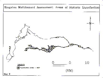
Following the 1907 earthquake, Brown (1907) mapped a zone of fissuring and subsidence 100 to 300 yards wide, which starting in the western part of Kingston, ran along the waterfront encircling the harbor and continued along the Palisadoes (see Figures 2.2 and 4.2). Soundings within the harbor revealed that the bottom had sunk in places around the edge of the harbor by 4 to 5 fathoms [24 to 30 feet].
The Palisadoes peninsula from Harbor Head to Port Royal - suffered extensive liquefaction and differential settling. Levels of ground shaking were so severe that surface waves were noted in Port Royal during the earthquake. Zones of ground failure also extended east of the Palisadoes, from Harbor Head to Bull Bay where soils consist of loosely consolidated coarse sands and gravels. Extrusion of sand/water near was noted at Victoria Market and along the Palisadoes (Fuller, 1907 p. 709). Increased flow was noted in a spring at Rockfort. This same spring flooded the road after the 1993 Woodford earthquake.
Damage in the Marina District in San Francisco, California during the 1989 Loma Prieta earthquake was strongly influenced by the location of artificial fill and construction rubble (Benuska, 1990). Areas of San Francisco Bay, such as Foster City and Redwood Shores, that were constructed on stabilized fills using appropriate geotechnical engineering techniques, performed better and had no appreciable liquefaction effects.
Reclaimed land is typically classified as being either engineered or non-engineered. Engineered ground consists of specially selected and prepared materials that are carefully deposited and compacted on site. Deposits are then tested to determine their load bearing strength. Non-engineered ground, on the other hand, consists of loose, uncompacted sands, fill, and construction rubble that have not been deposited in any systematic fashion. Both types of ground are identified as categories for special consideration in the National Earthquake Hazard Reduction Program (NEHRP) site classifications discussed in the next section.
Figure 4.3 shows the distribution of reclaimed land in the Kingston Metropolitan area. Areas of engineered and non-engineered fill are differentiated. The data used to construct Figure 4.3 were provided by the Urban Development Corporation (UDC), who are responsible for the redevelopment of the Kingston Waterfront in the Kingston Metropolitan Area, and from soil investigation reports from local geotechnical companies. Some of these soil reports date to the early 1950's. In general, the boundary between engineered and non-engineered fill approximates the old (pre-1950) coastline around Kingston Harbor.
The Kingston Waterfront re-development is mainly on engineered fill and contains many of the largest building structures, important industrial, harbor and warehouse facilities in the Kingston Metropolitan area. These include the Urban Development Corporation building, the Petrojam Oil Refinery, Newport West and New Port East harbor and warehouse facilities, the Bank of Jamaica building and Scotia Bank Center. Other important developments on engineered fill outside the Kingston Waterfront Redevelopment area include the Norman Manley International Airport at Palisadoes, the Portmore-Kingston Causeway and Portmore Housing Development in St. Catherine.
Engineered fill is composed of 2.4 to 7 meters of thick hydraulic fill consisting of fine to medium sand and gravel with a trace of shell fragments. The fill was engineered using ground improvement methods such as conventional compaction and surcharge. Periodic borehole and probe tests were done to determine the final bearing strength of the hydraulic fill for design and construction. Soil conditions underlying the engineered fill consist of from 1.5 to 6 meters of organic silt, fine sand and varying proportions of decayed vegetation (soft, compressible soil).
As seen in Figure 4.3, areas with significant concentrations of non-engineered fill are located in the western part of Kingston, south of Spanish Town Road. Here the composition is more variable and generally consists of from 1 to 3 meters of loose to uncompacted sands, gravel, construction rubble (brick and concrete), organic material, and cinder/ash. Soils underlying the non-engineered fill ranges from highly compressible organic silt and loose fine sand, soft clayey soil, marl and limestone chips. Standard geological criteria are of little use in characterizing soils within these fills, which are less homogeneous than natural deposits. There is no reason to assume lateral stratification in these fills and the validity of extrapolating subsurface data is questionable.

The Liguanea Plain is a Holocene gravel fan which was formed by sedimentation from the Hope River before the river was diverted to its present channel (Ahmad and Robinson, 1994). It incorporates a sequence of poorly sorted sands and gravels interbedded with sands and clays. The top 8 meters of fan sediments have been identified by Ahmad and Robinson (1994) as old debris flow deposits, characterized by very large boulders of andesite and conglomerate. Sources for the debris flows were ancient landslides, which originated in the catchment of the Hope River, and flowed westward along paleodrainage channels. Sediments that post-date the Liguanea gravels include fanglomerate and colluvium deposits along much of the mountain front in the Kingston area and river terraces, colluvium and flood plain deposits associated with the Hope River and its tributaries. The present day fan surface slopes southward towards Kingston Harbor. Farther west, mangrove and salina deposits dominate the Hunts Bay area.
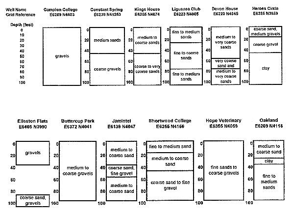
Well logs from 12 water wells drilled during 1977-1978 were used to determine soil profile types for the Liguanea Plain and are summarized in Figure 4.4. The complete logs are included in Appendix 2. The soil profiles are determined using the parameters defined by both the Structural Engineers Association of California (SEAOC, 1996) and the U.S. National Earthquake Hazards Reduction Program Recommended Provisions (NEHRP, 1997). Both classification schemes are based on geotechnical information, such as shear wave velocities, and Standard Penetration Resistance tests. Shear wave velocities are either directly measured using geophysical techniques, extrapolation of local data from the same geologic units, or estimated using established correlations from other geotechnical properties (e.g. Standard Penetration Test (SPT) and Cone Penetration Test (CPT) penetration resistance [see ASTM D 1536-84], void ratio, undrained shear strength [see ASTM D 2166-91 and ASTM D2850-87]) for each site. The water well logs summarized in Figure 4.4 did not contain these types of geotechnical information, so we used geologic analogs from investigations in the Los Angeles, CA area to help constrain the soil classifications (Fumal and Tinsley, 1985; Rogers et al., 1985).
The latest revision of the Jamaican Building Code recommends the use of the Caribbean Uniform Building Code (CUBIC) format for earthquake loads and adjusted the design philosophy to conform to the SEAOC code. Site coefficients or response factors, S, are assigned based on the soil profile. Table 4.1 lists the 1996 SEAOC coefficients and their descriptions. Soil profile, S3 is recommended by SEAOC in locations where soil properties are not known in sufficient detail to determine the soil profile type.
Type |
Description |
Coefficient value |
S1 |
A soil profile with either:
|
1.0 |
S2 |
A soil profile when predominately medium dense to dense or medium stiff to stiff soil conditions, where soil depth exceeds 200 feet (61 m) |
1.2 |
S3 |
A soil profile containing more than 20 feet of soft to medium stiff clay but not more than 40 feet of soft clay |
1.5 |
S4 |
A soil profile characterized by a shear wave velocity of less than 500 feet per second, and containing more than 40 feet of soft clay. |
2.0 |
Another site classification scheme, developed by the U.S. National Earthquake Hazards Reduction Program Recommended Provisions (NEHRP, 1997) is shown in Table 4.2. Site classes are determined by obtaining an average shear wave velocity for the upper 30 m (100 feet) of soil. Soil profile D is recommended for areas lacking geotechnical information.
Soil Profile Type |
Description |
Shear Wave Velocity |
Standard Penetration Resistance |
Undrained Shear Strength (kPa) |
A |
Hard rock |
>1,524 |
n/a |
n/a |
B |
Rock |
762 to1,524 |
n/a |
n/a |
C |
Very dense soil and soft rock |
366 to 762 |
> 50 |
>96 |
D |
Stiff soil |
183 to 366 |
15 to 50 |
48 to 96 |
E |
Soil profile with Vs <183 m/s, or any profile with more than 3 m of soft clay defined as soil with plasticity index > 20, water content >40%, and undrained shear strength <24 kPa. |
|||
F |
Soils requiring site-specific evaluation – including liquefiable soils, and peats or organic clays with thickness > 3 m |
|||
The maximum considered earthquake spectral response for short periods (SMS) and 1 second period (SM1), adjusted for site effects, is determined by multiplying the site coefficients in Table 4.3 and 4.4 by the respective levels of ground motion, SS and S1, respectively.
SMS = FaSS
SM1 = FaS1
These values are shown in Tables 4.5 for short period motions and Table 4.6 for long period (1 second) motions. Values appropriate for the Kingston Metropolitan area have been highlighted and range from 0.24 to 0.44, based on 10% probability of exceedence in 50 years on bedrock.
Experience has shown that low peak ground accelerations of 0.05 to 0.1g are amplified by factors of 1.5 to 4 at sites containing soft clay layers and depths to bedrock of several hundred feet. Average amplification for soft soil sites tend to decrease as the rock acceleration increases, from 2.5 to 3 at low accelerations to about 1.0 at rock accelerations of 0.4 g. This effect is directly related to the non-linear stress-strain behavior in soil as levels of acceleration increase.
Soil Profile Type |
Peak Acceleration |
||||
Ss < 0.25 |
SSs = 0.5 |
SSs = 0.75 |
SSs = 1.00 |
SSs > 1.25 |
|
A |
0.8 |
0.8 |
0.8 |
0.8 |
0.8 |
B |
1.0 |
1.0 |
1.0 |
1.0 |
1.0 |
C |
1.2 |
1.2 |
1.1 |
1.0 |
1.0 |
D |
1.6 |
1.4 |
1.2 |
1.1 |
1.0 |
E |
2.5 |
1.7 |
1.2 |
0.9 |
* |
F |
* |
* |
* |
* |
* |
Ss is the maximum considered earthquake, 5% damped, spectral response acceleration at short periods. * need to perform site-specific geotechnical analysis and dynamic site response analysis
Soil Profile Type |
Peak Acceleration |
||||
S1 < 0.1 |
S1 = 0.2 |
S1 = 0.3 |
S1 = 0.4 |
S1 > 0.5 |
|
A |
0.8 |
0.8 |
0.8 |
0.8 |
0.8 |
B |
1.0 |
1.0 |
1.0 |
1.0 |
1.0 |
C |
1.7 |
1.6 |
1.5 |
1.4 |
1.3 |
D |
2.4 |
2.0 |
1.8 |
1.6 |
1.5 |
E |
3.5 |
3.2 |
2.8 |
2.4 |
* |
F |
* |
* |
* |
* |
* |
S1 is the maximum considered earthquake, 5% damped, spectral response acceleration at 1 second period. * need to perform site-specific geotechnical analysis and dynamic site response analysis bold-italics illustrate range of Fa values estimated for the Liguanea Plain
Soil Profile Type |
Peak Acceleration |
||||
Ss < 0.25 |
Ss = 0.50 |
Ss = 0.75 |
Ss = 1.0 |
Ss > 1.25 |
|
A |
0.20 |
0.40 |
0.60 |
0.80 |
1.00 |
B |
0.25 |
0.50 |
0.75 |
1.00 |
1.25 |
C |
0.30 |
0.60 |
0.83 |
1.00 |
1.25 |
D |
0.40 |
0.70 |
0.90 |
1.10 |
1.25 |
E |
0.62 |
0.85 |
0.90 |
0.90 |
* |
F |
* |
* |
* |
* |
* |
* - need to perform site-specific geotechnical analysis and dynamic site response analysis
Soil Profile Type |
Peak Acceleration |
||||
Aa < 0.1 |
Aa = 0.2 |
Aa = 0.3 |
Aa = 0.4 |
Aa > 0.5 |
|
A |
0.08 |
0.16 |
0.24 |
0.32 |
0.40 |
B |
0.10 |
0.20 |
0.30 |
0.40 |
0.50 |
C |
0.17 |
0.32 |
0.45 |
0.56 |
0.65 |
D |
0.24 |
0.40 |
0.54 |
0.64 |
0.75 |
E |
0.35 |
0.64 |
0.84 |
0.96 |
* |
F |
* |
* |
* |
* |
* |
* - need to perform site-specific geotechnical analysis and dynamic site response analysis bold-italics illustrate range of Ca values estimated for the Liguanea Plain
Both the amplitude and duration of strong ground shaking are dependent on the thickness of the alluvium. Sites with thin alluvium tend to amplify over a narrow frequency range, while sites with thick alluvium amplify shaking over a broader range of frequencies. Variations in the thickness of Quaternary sediments in Los Angeles have been shown to produce factor of 5 variations in the spectral ratio of the horizontal component of ground motion, in the depth range 10-400 m for intermediate periods (affecting 5 to 30 story buildings) (Rogers et al., 1985). A rule of thumb for the fundamental period, T, of a multistory buildings is T = 0.1 s per story. In other words, a 20 story building would have a fundamental period of 2 seconds. For periods less than 0.5 s, the most significant factors controlling ground response are mean void ratio in the near-surface layers, the unconsolidated (Holocene) sediment thickness and depth to basement rock. For periods greater than 0.5 s, depth to basement and the thickness of Quaternary sediments were found to be controlling factors. These differences highlight the need for site-specific evaluation.
The predominant period of the soil deposit can be estimated (assuming vertically propagating waves in a linear elastic soil media) from the relationship
T = 4H/Vs
where H is the thickness of the deposit and Vs is the average shear wave velocity of the soil.
The depth to basement (in this study defined as Miocene limestone) or the thickness of the Liguanea alluvium is largely unknown. Well hole data (summarized in Appendix 2) indicate that of the 199 wells drilled, depth information was recovered for only 44 wells and only seven wells actually hit Miocene Limestone. A number of 200 m wells drilled for the Water Authority were useful in setting minimum depths to basement.
Estimates of the depth to basement were also determined using gravity measurements (see Appendix 3). Two-dimensional models generated from the gravity data were consistent with a north-south variation of alluvium thickness from less than 100 m near Constant Spring to approximately 500-600 m near Kingston Harbor. These values are also consistent with estimates from a simplified depth of overburden calculation (500 to 700m). From east to west along Old Hope Road and Washington Boulevard, the thickness of Liguanea alluvium ranges from 300 to 400 m with less variation.
We were not able to recover shear wave velocity measurements for the Liguanea plain. Instead, we rely on geologic analogs. Los Angeles, California has a geologic setting similar to the Kingston Metropolitan area - alluvial fan and river flood plain deposits. For the Liguanea Plain, we estimate the average shear wave velocity to be 320- 495 m s-1 range based on geologic parallels with measured parameters in the Los Angeles basin (Fumal and Tinsley, 1985). These values are consistent with the values for C/D soils in the NEHRP Site Classifications (366 to 762 m s-1, see Table 4.2).
Based on these parameters, H = 200 -700 m and shear wave velocities for type C soils in Table 4.2 (V = 366 to 762 m s-1), the fundamental periods, T, varies by a factor of two to three throughout the Kingston Metropolitan area (from approximately 1 to 2 sec for 200 - 300 m thick alluvium beneath Halfway Tree and New Kingston to longer periods, > 4 sec, at Kingston Harbor).
While the simple relationships developed in Section 4.5 provide guidance as to the period range at which site effects may be significant, they do not address the magnitude of the amplification of the ground motions. The NEHRP tables (Tables 4.1-3) provide general guidance and suggest that ground amplification is an important factor at the levels of acceleration expected for the KMA. More detailed analysis, however, requires information about the thickness and stiffness of soils and underlying rock, and the strain dependent properties of the soils themselves.
Aspinall and Shepherd (1977) modeled soil response for KMA using the computer program SHAKE (Schnabel, Lysmer and Seed, 1972) and generalized models of the Liguanea Plain. The ground motion estimates used as inputs into the model were for sources of varying magnitude and distance and ranged from M 7.5 at 160 km, to M 7.0 at 80 km, to M 6.0 at 50 km. This is motivated by Shepherd's (1971) conclusions that the majority of large earthquakes affecting Jamaica occurred off the north coast of the island. At that time there was a lack of detailed information about the depth to basement and subsurface lithology of the Liguanea Plain. Depths that were considered in their analysis ranged from shallow to approximately 350 meters and representative soil profiles were used that consisted of sand and clay layers at shallow depths (<50m) and all clay at depths greater than 50m.
We have updated the earlier Aspinall and Shepherd (1977) SHAKE study by
We use SHAKE21 to estimate ground response at a number of sites throughout the KMA - Elleston Flats, National Heroes Circle, and Buttercup Park. SHAKE21 (Kagawa, 1995) was written for Windows95/NT environment and is based on equivalent linear dynamic soil response method that computes the response of a horizontally layered visco-elastic system subject to vertically propagating shear waves. It computes strain-compatible shear moduli and damping ratios assuming an effective to peak strain ratio of 0.65, for all soil layers except the half space (which represents the hard rock basement).
SHAKE-type analyses are used in engineering practice and have been demonstrated to provide accurate results in situations where the ics represents non-strain compatible result.
Frequency (Hz.) |
||||
| Well Site | 0.5 |
1 |
10 |
30 |
| Elleston Flats | 2.2 |
1.5 |
0.67 |
1 |
| Buttercup Park | 0.9 |
0.7 |
1.7 |
1.1 |
| National Heroes Circle | 0.4 |
1.1 |
0.43 |
0.23 |
In each of the three sites studied, ground amplifications varied with both period and site conditions. In the absence of appropriate geotechnical information about down-hole conditions, the generalized SHAKE21 results in Table 4.7 should be taken with extreme caution. The NEHRP site classifications given in Table 4.2 would be more appropriate for use in generalized classifications of the KMA site response.
Recordings of small earthquakes can provide a direct measure of potential variations in site response during larger events. Studies in the San Francisco Bay region, Los Angeles, Caracas, Mexico City, Armenia (Rogers et al., 1985; Borcherdt et al., 1990) indicate that a comparison of amplitudes is a reliable indicator of the site amplification factor at a site with unconsolidated sediments when compared to a hard rock site for the same earthquake. Little work of this type has been done in the Kingston Metropolitan area to date.
Periera and Turnovsky (1978) published a comparison of strong motion recordings for the February 26, 1978 earthquake. For two stations (Mona and New Kingston) at comparable distances from the epicenter, there was a 30% variation in peak ground acceleration (see Table 4.8).
Port Antonio (rock site) |
Mona – Kingston (alluvium) |
New Kingston (alluvium) |
|
Hypocentral Distance (km) |
14 |
39 |
43 |
Peak Ground Acceleration (cm s-2) |
165 |
37.5 |
49.5 |
Average Acceleration (cm s-2 ) |
141 |
24.5 |
26.5 |
Cycles > Average Acceleration |
4-8 |
3-5 |
6-7 |
Predominant Period |
0.29 |
0.31 |
0.34 |
Predominant Frequency |
3.45 |
3.23 |
2.94 |
As part of the Seismic Hazard Assessment, a "weak motion" study was conducted using earthquakes that had been recorded by two stations in the newly installed and calibrated Jamaican Seismograph Network (See Figure 4.5 and Appendix 1 for description of the network). Digital recordings of small earthquakes at stations Stony Hill (STH) and Hope, Jamaica (HOJ) were compared to evaluate differences in signal character. STH is situated on Miocene limestone north of Kingston, while HOJ is located at the Mona Campus, on the Liguanea Plain between Long and Dallas Mountain. Depth to bedrock in the Mona area is estimated to be on the order of 50 m based on well data (Mona well, see Appendix 2).

Earthquakes within 150 km of the JSN and equidistant from STH and HOJ were chosen for the study to eliminate path and source effects. 18 earthquakes were examined (13 local and 5 teleseismc). Figure 4.5 shows a comparison of two earthquakes recorded by HOJ and STH. While the records from STH are 'clipped', a visual comparison indicates significant differences between these stations. While this exploratory study has demonstrated that differences in site response exist in the Kingston Metropolitan area, these few data show no clear patterns. Future deployments of portable seismographs throughout the Kingston Metropolitan area to measure differences in ambient noise levels can provide relatively low cost estimates of earthquake site response.
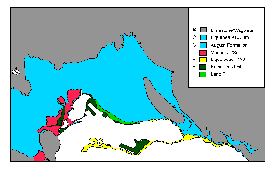
Figure 4.6 shows the composite site condition map for the Kingston Metropolitan area based on mapping historic observations of ground failure, reclaimed land and the soils data that were collected during Phase One of the Seismic Hazard Assessment. These data are assigned a soil profile type according to the NEHRP classification in Table 4.2. From a seismic hazard perspective, the areas most vulnerable to strong ground shaking lie in the vicinity of the Palisadoes and Kingston Harbor.
In Figure 4.7, we have modified the NEHRP B soil ('hard rock') ground motions from Figure 3.7 by using the site conditions in Figure 4.6 and the NEHRP site response coefficients in Table 4.4. For simplicity, we have assumed a B soil ground motion of 30% and have modified local site conditions accordingly. The lack of ground motion for 'F' type soil reinforces the need for site specific geotechnical analysis and dynamic site response analysis.

There are a number of limitations to the maps produced by the KMA Seismic Hazard Assessment. Recognizing this, the following guidelines are provided for the proper use and interpretation of the study results.
Building codes are the primary means of mitigating the effects of strong earthquake shaking on buildings. The effects of local surface geology on expected shaking is accounted for by the use of seismic coefficients in the lateral force formula which corresponds to the soil profile types defined in various building codes and recommendations (e.g. section 4.3 of this study and the Uniform Building Code (ICBO, 1997); NEHRP Recommendations (1997)).
The maps produced by the KMA Seismic Hazard Assessment contribute to the success of the building code process and the establishment of minimum safety standards and acceptable levels of risk in Kingston. By acceptable level of risk, we mean a reasonable protection of public safety to reduce the risk for ground failure during an earthquake to a level that does not cause the collapse of buildings for human occupancy, but not to a level of no ground failure at all. Note this definition of acceptable level of risk is based on a life safety criterion for buildings, and may need to be defined differently for infrastructure and port facilities.
The maps produced by the KMA Seismic Hazard Assessment delineate seismic hazard zones, either actual fault zones (such as the Plantain Garden Fault) or areas susceptible to ground failure (such as the Palisadoes). These maps were developed using a combination of historic records, field investigations, and computer based modeling and mapping technology. These maps may not, however, identify all areas that have a potential for liquefaction, ground failure, strong ground shaking or other geologic hazards. Neither the maps nor the information on how the maps were prepared should be used as a substitute for site-specific investigations.
The maps should be used to guide development in seismic hazard zones, to promote effective implementation of evaluation and mitigation measures throughout the Kingston metropolitan area, to ensure that appropriate soil and geotechnical investigations are conducted, and that appropriate mitigation measures are incorporated into the development process. Mitigation measures are those consistent with established practice to reduce seismic risk to acceptable levels.
The object of detailed field investigations is to obtain sufficient information so that engineers and geologists can evaluate the nature and severity of the risk and develop a set of recommendations for mitigation actions. Detailed investigations commonly involve the collection of subsurface information through trenches, borings on or adjacent to the site. The subsurface exploration should extend to depths sufficient to expose geologic or subsurface water conditions that could affect slope stability or liquefaction potential.
| CDMP home page: http://www.oas.org/en/cdmp/ | Project Contacts | Page Last Updated: 20 April 2001 |