![]()
![]()
![]()
![]()
![]()
I. Introduction
II. Designing the study
III. Executing the study
IV. Implementing the recommendations
V. Lessons learned
VI. Bibliography
![]()
PROBLEM SUMMARY
Formulating an Integrated Management Plan for a Natural Reserve - The San Lorenzo Canyon Study (Mexico)
The San Lorenzo Canyon study (1979-1981) was launched to assess the resource potential of various ecosystems within a single valley, to determine the geographical boundaries of a proposed research reserve, and to help design a cooperative local management authority for the valley. Once the study was initiated, the planning team was forced to re-evaluate the original study objectives and to expand a single-sector project into an integrated development project.
Working with members of the Natural Resources Department of the Autonomous Agrarian University "Antonio Narro," (UAAAN), a DRD natural resources specialist helped refocus what began as an academic research project into a multiple-use development plan based largely on watershed management. During this re-evaluation, the project beneficiaries expanded from two groups (university researchers and the tourists who were to be allowed into the study area on a limited basis) to several (the original two and local farmers, politicians, businessmen, and developers).
The planning team zoned the 91.5 km2 area and proposed uses for each zone based on native potential and the project's objectives. It made various integrated resource-management proposals to be executed in three phases.
MEXICO - THE SAN LORENZO RESERVE STUDY - Fact Sheet
|
Project area: |
91.5 km2 | |||
|
Population: |
1,000 (approximately) | |||
|
Physical characteristics: | ||||
|
|
- Warner and Riskind life zones: | |||
|
|
|
Pine juniper forest | ||
|
|
|
Chaparral | ||
|
|
|
Oak forest | ||
|
|
|
Dense thornless brush | ||
|
|
|
Thorny desert and cactus with underlying grasses | ||
|
|
- Elevation range: 1,700 to 3,100 m | |||
|
|
- Land capability classification: | |||
|
|
Classes I-III: |
20% | ||
|
|
Classes IV-VIII: |
80% | ||
|
Duration of Project: | ||||
|
|
Preliminary Mission: 5/1979 | |||
|
|
Fieldwork: 9/1979-12/1981 | |||
|
|
Publication of Final Report: 1981 | |||
|
Technical contributions: | ||||
|
DRD discipline areas (3) |
Number of DRD Experts (3) | |||
|
Natural Resource Specialist (International Director) |
1 | |||
|
Environmental Management Advisor |
1 | |||
|
Regional Planner |
1 | |||
|
Total professional person-months: DRD: 29.6 Government of Mexico: 41.3 | ||||
|
Financial contributions: DRD: US$133,000 Government of Mexico: US$233,000 | ||||
|
Total investment in projects proposed: N/A | ||||
The need for national parks and protected areas in developing countries is growing, especially in rapidly urbanizing areas where demands for recreational, educational, and scientific uses can conflict with agricultural and urbanization demands. As land values rise and competition between alternative uses increases, the need for a planning approach that considers all users and both present and future demands becomes more pressing. But formulating a plan is far simpler than finding a politically acceptable way to implement it.
This account of the San Lorenzo Canyon study addresses these issues. While planning a reserve at first appears to be a limited affair, it actually brings all the principles of regional planning into play. This study involved:
· Integrating a local sector-specific plan with regional and national development plans;
· Cultivating inter-agency cooperation in preparing and implementing a development plan;
· Acclimating host-country scientists and social scientists to participating in regional planning;
· Designing a management authority to represent all the users and keep the program going;
· Re-evaluating initial study objectives; and
· Expanding a single-sector project into an integrated development project.
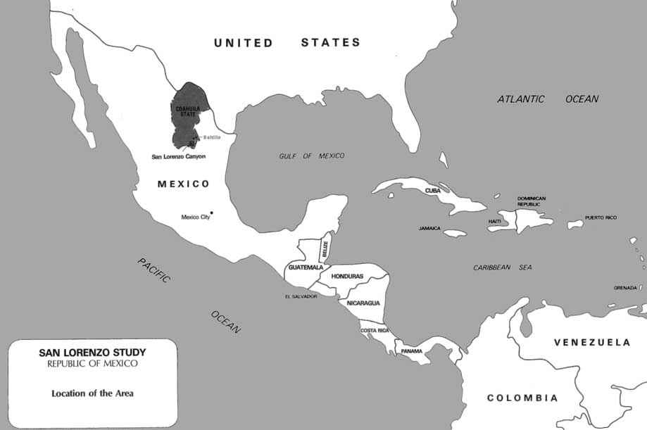
By the year 2000, Mexico City is expected to have 31 million inhabitants, making it the world's largest metropolis. As part of a national strategy to control and manage population growth, industrial centers are being expanded in other Mexican cities, particularly in the sparsely populated north. One urban center selected for development is Saltillo, a city of 300,000 situated in a desert basin of the Sierra Madre Oriental. (See Map 1.) Automobile and steel plants have recently been built in Saltillo, partly because of government incentives. As a result of this stimulus and other factors, Saltillo's population is expected to double before the decade's end, and demands for all basic resources have increased greatly already. Clearly, with development of this scale and pace, only an integrated regional approach to planning can direct growth and avert negative impacts and irreversible problems.
Despite these large problems, the San Lorenzo study initially had a narrow purpose. When the Autonomous Agrarian University "Antonio Narro" (UAAAN) approached the Mexican Government in 1978 about establishing a protected area in the San Lorenzo Canyon area, the impetus was simply to conduct research to improve natural resource management, though limited public access for recreation and education was to be permitted. When the Mexican Government subsequently asked the OAS Department of Regional Development (DRD) for technical assistance in preparing a plan for the San Lorenzo Canyon, the hope was that the plan would also serve as a model in areas with similar ecosystems, but nothing approaching an integrated plan was envisioned. Only after fieldwork commenced did it become clear that the management of the Canyon could benefit the two local ejidos1 and Saltillo.
1. Peculiar to Mexico, ejidos are former private estates acquired by the state and redistributed to a group of country dwellers. They function as government-subsidized rural villages oriented toward agricultural production. Pasture, woodland, and cropland are held by the community. Small plots of arable land are also allocated by elected managers on a semi-permanent basis to families for personal gardens. The two ejidos included on the study area are Cuauhtemoc and Sierra Hermosa.
Water became the focal point of the planning process and the measure of all development alternatives. Since 40 percent of Saltillo's water supply (some 5,000,000 gallons per day) comes from three wells in the San Lorenzo Canyon seven kilometers south of the city, the importance of carefully husbanding this resource was clear to politicians, farmers, businessmen, and developers.
This case study summarizes DRD participation with UAAAN, the counterpart agency, mainly between September of 1979 and December of 1981. It focusses on the adjustment of project objectives and scope, institutional arrangements, the preparation of a multiple-phase management plan, the involvement of interested parties, and implementation techniques.
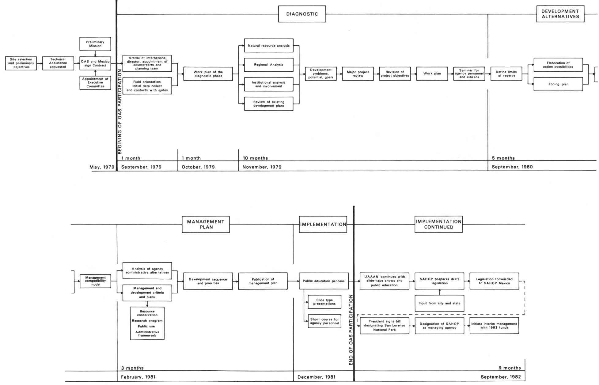
UAAAN owned part of the San Lorenzo area and had for some time been conducting ecological research both there and on adjacent ejido lands. On the basis of this research, several professors in the Department of Renewable Natural Resources came to believe that only by establishing a UAAAN-controlled reserve would the Department be able to carry out reliable studies. Plans for establishing such a reserve began taking shape in May of 1979, when the Mexican Government signed a contract with OAS.
On a preliminary mission at that time, a DRD advisor met with university representatives in Saltillo. They agreed that a Project Executive Committee consisting of UAAAN's rector and the DRD's director should be established. They also set the following four objectives, which were broader than UAAAN's original objectives but narrower than those finally adopted:
1. Create a planning methodology applicable to geographically similar areas in northern Mexico;2. Implement the methodology and establish the reserve;
3. Establish planning classes in the UAAAN's Departments of Forestry and Renewable Natural Resource Management; and
4. Design and develop an environmental education framework for visitors to the reserve.
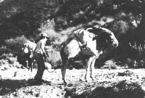
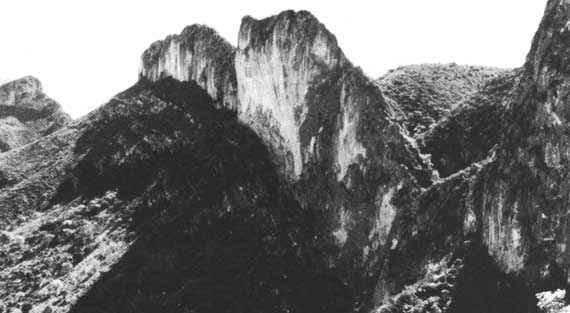
The San Lorenzo Reserve in the background with land of the Ejidos in the foreground.
With the arrival of the International Director in late 1979, UAAAN named a multidisciplinary planning team, thus completing the organizational structure of the study. (See Figure 1.)
This team reviewed previous and ongoing research in the San Lorenzo area relative to the preliminary study objectives, which enabled it to identify gaps in information about the area's natural resources, land use, tenure patterns, and the economy of the ejidos.
A. Preliminary Fieldwork
Between October of 1979 and August of 1980, the study team conducted extensive field visits and aerial surveys in the canyon. To document land-use trends and their impact on the natural resource base, it compared its findings with benchmark data from previous UAAAN and government studies.
One important conclusion was that once-acceptable land-use practices had over the years notably altered the canyon's resource base. Virtually all forest cover had, over the years, been cut over or burned since 1920 without compensatory reforestation; primary-growth stands of pine, juniper, and fir were confined to the most inaccessible crests and canyons. Pine forests had regenerated naturally in some areas, covering 20 percent of the 9,150 ha proposed for the reserve, but the remaining 80 percent had regressed to chaparral and woody shrubs.
Timber removal continues today in San Lorenzo Canyon, even though Mexico's Agrarian Reform Act prohibits harvesting anything but dead or downed trees. Tree poachers circumvent the law by girdling trees so they dry out and can be cut "legally" for use as firewood, construction lumber, and posts.
Water supply has also fallen as a result of continued overgrazing, erosion, and a reduction in the ground-water-recharge. By most estimates, only 5 percent of the precipitation the area receives reaches the aquifer. Moreover, according to the study's hydrogeologist, much of the water Saltillo obtains from the San Lorenzo Canyon is fossil in nature, and an irreversible water-recharge deficit has been building for several years as demands upon the supply have increased. In short, Saltillo has been "mining" water instead of managing it. Indeed, the region's groundwater levels have fallen more than 300 meters during the last ten years, and to get ever-increasing quantities of high-quality water to meet domestic, agricultural, and industrial needs, Saltillo must now drill to depths greater than 1,200 meters.
Figure 1 - ORGANIZATIONAL STRUCTURE
The study team also discovered that human intervention has seriously harmed wildlife populations in the San Lorenzo Canyon. Habitat destruction through deforestation and other activities is so advanced in some places that certain populations cannot recuperate naturally. One of the few large mammals remaining in the reserve is the white-tailed deer (Odocoileus virginianus), and even its numbers are in decline. Unregulated hunting and trapping have also taken their toll on bird populations. For example, the maroon-fronted parrot (Rhynchopsitta terrisi), the only parrot known to nest in this high-desert zone, is now considered endangered.
While no statistics on current recreation use were available before this study began, historical records verify that the San Lorenzo's wildlife and running water drew considerable numbers of hikers, campers, photographers, and hunters to the area early in this century. Even as recently as 1980, more than 5,000 people - most of them in groups that come for one day only - visited San Lorenzo Canyon. Demand for outdoor recreation and education will no doubt continue to increase, even though in recent years litter, human waste, man-caused fires, graffiti, and tree blazing have dampened the appeal of many popular campsites.
The study team also discovered that great quantities of organic soil and river gravel had been removed from the canyon for landscaping and construction. Most of San Lorenzo's highly compactible clay soils have limited agricultural potential. Until recently, individuals who removed soil used primitive methods on a small scale, but they now use heavy equipment, so the impact on groundwater-recharge areas and river courses has multiplied. While soil removal is illegal, none of the government agencies working in the area has had the authority or manpower needed to control it.
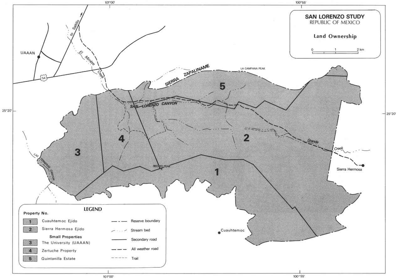
One of the most urgent problems the study team confronted was that of determining who owned the land proposed for the reserve and how best to acquire it. (See Map 2.) Although the San Lorenzo Canyon was un-inhabitated, cadastral records indicated that 64 percent (5,832 hectares) of the study area was owned and utilized by two ejidos, while 23 percent (3,318 hectares) was privately held in two large parcels. Since UAAAN assumed that effective long-term management would require control of all the reserved lands and the University owned only 13 percent of the proposed reserve, the study team had to consider recommending use restrictions on those ejido and privately owned lands that could not be acquired.
Although neither of the two private parcels was generating any income for the owners at the time of the investigation, the ejido lands proposed for the reserve were supporting some livestock and supplying timber, nuts, bark, and moss. While both ejidos derived most of their income from annual crop production in the low, fertile valleys near their communities, they supplemented their income by exploiting nearby forests. Sierra Hermosa stood to lose direct control over nearly 45 percent of its land if the reserve was established.
The study team's review of regional and national plans revealed that both the State Ecological Development Plan (ECOPLAN) and the Coahuila Development Plan had made the creation of an ecological reserve a regional development priority, In addition, the President of Mexico, Lic. José López Portillo, declared in 1980 that managing lands for multiple uses (including preservation) was essential for Mexico's economic and social stability, particularly in arid regions. At the time, the International Union for the Conservation of Nature and Natural Resources (IUCN) and the OAS had also recently declared the importance of establishing reserves in this biogeographic province.
B. Analysis of Preliminary Fieldwork
Once the preliminary fieldwork had been completed and the area's conditions and problems cataloged, the planning team reviewed the results and exchanged ideas on the study's future. A DRD natural resources specialist from Washington, D.C., participated in this exercise, which took place in August of 1980 in Saltillo. This review proved critically important for the university professors on the planning team, few of whom had worked on an interdisciplinary team with practical rather than academic objectives. Accustomed to working on highly specific problems, the university team members feared that their work would be diluted by another investigator's in the final management plan. Many guarded their own field data, apparently to avoid review by peers and government agencies and to protect publishable information, and some were reluctant to collect field data since this task is usually assigned to students.
As it turned out, these conflicts were minimized by making the participants themselves responsible for resolving their differences. This method of mediation enhanced communication, improved the team's understanding of the concepts underlying multiple-use resource management, and forced appreciation of an interdisciplinary approach to problem resolution. Nevertheless, some adjustments were painful and some problems were never resolved. For example, some senior faculty members would not allow the national field counterpart, a junior staff member, to evaluate their field reports. Additionally, several UAAAN team members did not want to participate in field visits, but chose to send a student proxy. Last, since most team members were "nominated" by UAAAN's rector without being granted any compensation or release time for the study, the study was not their highest priority.
The study's scope was broadened after the Saltillo meeting from that of reserve management for research purposes to that of multiple-use resource management for the whole community's benefit. Because the multiple-use plan was compatible with integrated programs at both national and regional levels, Mexican agencies became more receptive and cooperative, and there was a check against the tendency to diffuse or duplicate efforts - a common pitfall of projects conceived in isolation and sectorally implemented. Moreover, the study probably received more political support than it would have if it had not been restructured.
C. Revised Study Objectives
Partly as a result of the review, the study's objectives were reorganized into three major categories: natural resources, rural development, and public use. (See Table 1,) The workplan based on the revised objectives allocated tasks implicit in the objectives to members of the planning team, indicated the interrelationships of the tasks, and scheduled each.
While the research on natural resources remained UAAAN's main interest, the study team became more committed to both the rural development and public use objectives. In September of 1980, the team held a public seminar to explore the evolution of the concept of the reserve from that of a university research area to that of a community resource. This seminar drew 300 students and citizens, as well as favorable articles in the local press. It also prompted three university classes to examine the canyon planning process, Despite this warm reception, however, UAAAN held fast to its policy of excluding the general public from decisions about the study. It also excluded property owners on the assumption that they could use the information for private gain and thus thwart the study's goals.
Too general to act upon or measure, the original objectives for the study also ignored the considerable difficulty of getting study team members from different disciplines to adopt common management objectives. This problem was intensified when, shortly after DRD got involved, the prime mover behind the reserve project left UAAAN for reasons unrelated to the study. An orientation session helped mitigate such problems, but an even better approach would have been to involve all team members in objective-setting and the other early study phases.
D. Local and State Cooperation
At the study's outset, UAAAN decided against inviting ejido representatives to participate in project planning. But review of the cadastral data and the economic structure of the ejidos made the importance of their cooperation clear. Formal contracts with the Secretariat of Agrarian Reform would have to be drawn up to compensate the ejidatarios and other property owners for their land and for the opportunity costs of resource exploitation.
When projects involve rural populations who have limited opportunities to express their needs, the national agency sponsoring the project should actively and regularly fulfill this communicator role in the field. In the San Lorenzo study, this ideal was never fully attained. Even though the national and international co-directors visited the communities several times, the ejidatarios never became actively involved. They remained skeptical of the study goals since past promises of assistance had not been kept. To them, designating the San Lorenzo Canyon as a reserve meant only that their freedom to exploit the forests and pastures would be proscribed. They had little hope that government agencies could be convinced of the need for such practical rural development projects as wells, irrigation systems, and agricultural credit for crop cold-storage units - all of which they viewed as more fundamental to their long-term progress than a reserve.
As a result of the review meetings, the study team also asked the state delegations of the Secretariat of Agriculture and Water Resources (SARH), the Secretariat of Human Settlements and Public Works (SAHOP), and the Secretariat of Agrarian Reform (SRA) to comment on the study team's reports and management recommendations in the latter phases of the project. Like the ejidatarios, agency representatives participated only informally and sporadically, but their help did prove valuable later.
The political importance of the San Lorenzo Canyon management's impact on Saltillo's water supply prompted the team to reorder the study priorities. While they considered research and recreation development laudable social goals, local decision-makers were much more interested in the municipal water supply. In turn, they ultimately motivated the Governor, who helped by proposing solutions to the land-tenure problem and developing a scheme for financing rural development projects. (A new Governor was installed in Coahuila in late 1981, and contacts were made with appropriate state agencies just before DRD involvement ended.)
Table 1 - MANAGEMENT OBJECTIVES FOR THE SAN LORENZO RESERVE
|
Output Group |
Product Output |
Management Objective Statement |
Management Actions |
|
I. NATURAL RESOURCE |
Water production |
To propose a specific management plan to insure long-term water production for Saltillo |
- Regulate tree harvesting and grazing |
|
Endangered species maintenance |
To conserve and protect representative ecosystems (where possible, in a natural state) |
- Establish protected habitat zones |
|
|
Ecosystem regulation |
To conserve ecosystems and genetic diversity |
- Preserve and protect representative ecosystems in the reserve |
|
|
Wildlife production |
To implement regulations to insure repopulation or reintroduction of depleted native species |
- Complete field research |
|
|
II INTEGRATED RURAL DEVELOPMENT |
Economic stability for local rural inhabitants |
To promote the rational use of the area's natural resources as part of an integrated rural development program |
- Make contracts with ejidos and reserve administration outlining
natural resource utilization |
|
Production of animal protein |
To produce animal protein for human consumption through a wildlife management program |
- Complete basic field research concerning carrying capacity and optimum
wildlife population levels with specific reference to game levels |
|
|
Wood and forage production |
To manage designated areas to increase the production of both wood and forage on a sustained-yield basis |
- Implement of multiple-use management zones near Sierra Hermosa and Cuauhtémoc ejidos |
|
|
Consolidation of reserve lands under administration of SARH or SAHOP* |
To resolve potential conflicts with private land-owners and ejidatarios |
- Purchase, exchange, or expropriate life-term agreements |
|
|
Future development/management options |
To maintain flexibility of future management for multiple uses |
- Implement management and rural development plans |
|
|
III. PUBLIC USE |
Data base for management |
To implement a coordinated research effort to gather both natural resource and user data |
- Make contracts with research institutions and managing agency |
|
Recreation use |
To provide facilities for outdoor recreation in accordance with the management objectives |
- Designate intensive, extensive, and primitive use zones |
|
|
Informed public (on site) |
To facilitate opportunities for visitor understanding of the natural phenomenon and the relationship of the reserve to the community |
- Complete and implement interpretative plan |
|
|
Informed public (off site) |
To maintain sites for field trips of students from Saltillo and surrounding communities |
- Contact schools |
* SARH: Secretariat of Agriculture and Water Resources. SAHOP: Secretariat of Human Settlements and Public Works.
Figure 2 - CRITICAL PATH FOR THE PLANNING OF THE SAN LORENZO RESERVE
In retrospect, it appears that a government agency may have been a more appropriate counterpart institution than a university. Primarily a research and teaching institution, UAAAN has no mandate to manage a regional development project or even a reserve area. Naming SARH as the counterpart agency, for example, would have reduced the chance of conflicts over jurisdiction and responsibilities associated with the area's long-term management. Unlike UAAAN, SARH has park-management experience, funds, and manpower.
Once the revised workplan was completed, the planning team was prepared to set the reserve boundaries, determine potential uses, establish land-use zones, identify potential uses within the zones, rank and synchronize the potential uses in accordance with the development objectives, and prepare a management plan. (Figure 2 shows the sequence of activities of the study and follow-up activities.)
The study team met monthly to discuss progress and resolve problems. By April 1981, the work was completed and the team's report, "Multiple Use Management Plan for the San Lorenzo Canyon," was published.
A. Development Alternatives
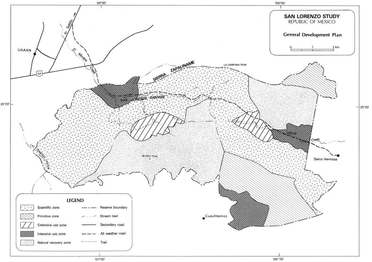
The boundaries of the reserve were determined primarily by natural geographic features. Arable land on ejido property was excluded, but all marginal and unproductive land was included. Once the total area was determined, all potential uses and activities were listed. The zoning scheme developed for the 9,150 ha was compatible with the range of objectives identified earlier. (See Table 2 and Map 3.)
Generally, areas in Categories A and B protect important water recharge and upstream-catchment zones, threatened flora, and habitats for important wildlife. They also provide for scientific research in natural areas and in disturbed areas under natural recovery. A limited number of visitor access trails will also be allowed to cross these areas. Extensive use zones (Category C), in contrast, are dedicated to primitive outdoor recreation. In some cases, they are also used to maintain disclimax vegetation (see Glossary) for recreational or aesthetic purposes. Lands in Category D are intensively developed and situated near major access points. While the natural appearance of Category D lands should be maintained, parking lots, restrooms, camping areas, interpretative trails, visitor facilities, and tourist services will be allowed. Additionally, three areas have been zoned for natural recovery (Category E) until the resources can be rezoned to permanent categories. (In two such natural recovery areas, the ejidos will manage sustained timber production and grazing.)
Once the zoning scheme was developed and approved, a compatibility matrix was prepared. This matrix took account of the objectives the reserve was designed to serve, the amount of land in each zone, and all resource-development opportunities and activities. This information formed the basis for the reserve management recommendations, and it helped the team rank project priorities and stagger the development tasks so as not to exceed the land's carrying capacity.
Table 2 - PROPOSED ZONING SCHEME
|
Category Zone/Specific Areas |
Hectares |
% of Reserve |
|
A Scientific (research/watershed protection) |
4,092 |
45 |
|
B Primitive (watershed protection/recreation) |
1,302 |
14 |
|
C Extensive Use (recreation/watershed protection) |
460 |
5 |
|
D Intensive Use (recreation/education) |
847 |
9 |
|
E Natural Recovery (eventually scientific, and, in the ejidos, agricultural and commercial) |
2,449 |
27 |
|
Totals |
9,150 |
100.0 |
Finally, a review of all existing Mexican conservation categories - national park, national forest, watershed district, wildlife reserve, and nature reserve - revealed that none was appropriate for San Lorenzo Canyon. While the study team director proposed adopting one of the internationally accepted IUCN management designations, the team chose to create a new broad management category within the Mexican system - an "ecological reserve" in which multiple and maximal use of the site's natural resources would be permitted. (See Glossary.)
B. Management Recommendations
To meet the project objectives and to retard resource degradation, the team recommended eight actions. (1) Designate a management agency to resolve the land-tenure issue. (2) Through this agency, enforce interim management measures, including a phased reduction of forestry and grazing and an immediate cessation of hunting, trapping, and soil collection. Once the economies of the ejidos are stabilized, proscribe timber and grazing activities except in designated zones. (3) Consider acquiring resource-development rights on private lands through purchase at market value, property exchange, life-lease agreements, or other arrangements. (4) Help SARH and the Secretariat of Agrarian Reform (SRA) prepare contracts defining future use of ejido lands. (5) Request national and international funds to help local rural inhabitants improve crop production and start new fruit-growing and Christmas-tree operations modelled after successful apple and pine-tree production in the area. Include the construction of wells, reservoirs, and irrigation systems for both ejidos in this effort. (6) Reforest approximately 5,000 ha in the ejidos (3,400 ha) and the private parcels (1,000 ha) with native pine and juniper to determine how quickly these forests can reproduce. (7) Take soil-conservation and fire-management measures, eliminate undesirable vegetation, improve specific habitats, and (eventually) reintroduce certain wildlife species. (8) Implement an outdoor recreation and education development scheme.
Obviously, not all these actions could be undertaken at once. The planning team therefore recommended that development be phased in three stages of approximately one year each as finances became available. (See Table 3.)
Table 3 - PROPOSED DEVELOPMENT AND MANAGEMENT SEQUENCE
|
Activity |
Phase |
|||
|
I |
II |
III |
||
|
LEGAL AND ADMINISTRATIVE |
||||
|
|
- Secure endorsement from Government of Coahuila |
X |
|
|
|
|
- Designate managing agency |
X |
|
|
|
|
- Officially establish the San Lorenzo Canyon |
|
|
|
|
|
Ecological Reserve and set reserve boundaries |
X |
|
|
|
|
- Begin purchase negotiations with ejido and private property owners, and find funds for the purchases |
X |
|
|
|
|
- Establish a task force (citizens and professionals) to assist the management agency In public relations |
|
X |
|
|
|
- Review and approve management plan |
|
X |
|
|
|
- Establish contracts with the ejidos outlining natural resource use within the reserve |
|
X |
|
|
|
- Initiate extension-education program with ejidos |
|
|
X |
|
|
- Sign contracts with ejidos |
|
|
X |
|
RESOURCE CONSERVATION |
||||
|
|
- Gradually suspend all grazing and forestry activities until ejidos sign contracts |
X |
|
|
|
|
- Suspend all hunting, soil, and plant extraction |
X |
|
|
|
|
- Close areas for Natural Recuperation Zones |
X |
|
|
|
|
- Initiate ranger patrols |
|
X |
|
|
|
- Initiate reforestation and erosion- control programs |
|
X |
|
|
|
- Eliminate introduced plant species In land categories A-C |
|
|
X |
|
|
- Reintroduce selected animal species |
|
|
X |
|
|
- Assess potential for expanding reserve |
|
|
X |
|
|
- Implement comprehensive resource- management programs |
|
|
X |
|
RURAL DEVELOPMENT |
||||
|
|
- Drill wells for domestic water in ejidos |
X |
|
|
|
|
- Construct irrigation infrastructure |
|
X |
|
|
|
- Plant fruit and pine trees |
|
X |
|
|
|
- Launch extension program |
|
|
X |
|
PUBLIC USE |
||||
|
|
- Develop and distribute reserve orientation brochure |
X |
|
|
|
|
- Initiate interpretation and environmental |
|
|
|
|
|
education management plans |
X |
|
|
|
|
- Contact local schools and complete teacher packets |
|
X |
X |
|
|
- Prepare orientation slide-tape or film |
|
X |
|
|
|
- Begin posting signs |
|
X |
|
|
|
- Construct visitors center and interpretation trails |
|
X |
|
|
|
- Implement Interpretation and environmental-education programs |
|
|
X |
|
FACILITIES AND CONSTRUCTION |
||||
|
|
- Contract construction firms to design and construct buildings, parking facilities, camping and picnicking areas, trails, etc. |
X |
|
|
|
|
- Drill wells |
|
X |
|
|
RESEARCH |
||||
|
|
- Establish administrative guidelines for research program |
X |
|
|
|
|
- Begin gathering baseline data and initiate monitoring program |
X |
|
|
|
|
- Establish research extension program |
|
|
X |
|
PERSONNEL |
||||
|
|
- Designate superintendent |
X |
|
|
|
|
- Hire division chiefs, establish Interim regulations, and prepare Initial budget |
X |
|
|
|
|
- Design orientation course for reserve employees and concessionaires |
|
X |
|
|
|
- Hire and train rangers and interpreters |
|
X |
|
|
|
- Implement comprehensive personnel program |
|
|
X |
The final project document was presented to the Mexican Government in April of 1981. Once approved by the counterpart institution, it was distributed throughout Mexico, Until December of 1981, the study team focussed on increasing public and agency support for the plan, particularly with state and federal institutions in Coahuila. With less than six months remaining in his term of office, the Governor of Coahuila was reluctant to endorse the San Lorenzo Management Plan, but UAAAN invited the new gubernatorial candidate to a presentation of the plan and garnered his aides' support. At the same time, the public at large was invited to a slide-tape program outlining the planning process and recommendations. This program was presented at 19 public offices, schools, and private civic clubs between June and November of 1981.
A. A Strategy Seminar
At the project's outset, DRD team members assumed that UAAAN would take long-term responsibility for managing the reserve, that land-ownership would be transferred to the university, and that administration would be oriented toward research and field laboratory exercises. However, when the complexity of the management of the restructured study became clear, the study team recommended transferring authority for the reserve to either SAHOP or SARH since both had helped plan the study and both would have to help implement the recommendations regardless of which assumed final responsibility. Under the revised framework, UAAAN would assume administrative responsibility for the research program only.
To promote the revised project, DRD, UAAAN, the Autonomous University of Nuevo Leon (UANL), UNESCO, and the Latin American Social Science Faculty (FLACSO) offered a seminar for public agency administrators in October of 1981, The objective was to design a realistic strategy for implementing the recommendations of the San Lorenzo Canyon plan. Because the State wanted to apply the San Lorenzo model to the Cumbres de Monterrey area, the course was offered at the School for Advanced Architectural Studies of the UANL in Monterrey, Nuevo Leon. The seminar also helped local institutions acquire international support for the project via televised interviews, newspaper articles, and the publication of the seminar proceedings - a clear benefit of working with such major institutions as SAHOP and SARH. The 20 participants represented a variety of disciplines and agencies.
The seminar participants used FLACSO's methodology which helped to:
1. Review the region's economic conditions, prospects, and resource trends, evaluating major problems encountered and analyzing proposals for implementing the plan;2. Examine selected recommendations and development alternatives in view of political and institutional realities;
3. Identify the actors involved and their interrelationships; and
4. Redesign the scheme for implementing the development plan.
This review yielded two important conclusions. First, resource degradation was primarily a political and economic issue: ejidos in remote arid areas tended to receive fewer benefits from extension agencies or Rural Bank credit programs than those nearer to the capital. Second, Mexico's institutional framework makes it difficult to address the chain reaction of problems caused by overusing a natural resource. Most integrated development programs involve several agencies, and cooperative efforts are too often hampered by conflicting legislative mandates. Consequently, efforts are duplicated, gaps are left in development programs, budget cycles are uncoordinated in multi-agency projects, and inter-agency rivalries occur.
Aware of these institutional failings, the seminar members first called for a new autonomous regional development and management authority. But, since similar bodies had not functioned well in Mexico, this option was disregarded. The group subsequently proposed that either SAHOP or SARH draft legislation that would address the need for inter-agency coordinating powers to insure that Mexican development projects are truly regional and integrated. It also recommended that such legislation authorize credit arrangements to guarantee development funds for the ejidos.
The seminar participants also identified all the "actors" in the region - many of whom had escaped notice during the planning process. This exercise brought to light the key roles that the National Federation of Small Farmers (CNC) and the Rural Development Bank play in implementing rural development projects in the ejidos.
After the seminar proceedings were distributed in December of 1981, DRD's direct involvement terminated. However, UAAAN promoted several recommendations made by the study team and the seminar participants, so the plan stands a good chance of being implemented.
B. A New Decree
In early 1982, at UAAAN's suggestion, the state delegation of SAHOP drafted a decree establishing San Lorenzo as an Ecological Reserve. (A recent law granted explicit powers for such designations on the President's recommendation.) A revised document endorsed by the City of Saltillo and the State of Coahuila was then forwarded to SAHOP's national office, The proposed law establishes guidelines for acquiring private lands and those ejido lands that will not be managed for timber and grazing in the future. If approved, it will allow a number of federal agencies to implement an integrated rural development plan for both Sierra Hermosa and Cuauhtemoc - avoiding the need to create a specialized management authority.
Some changes will naturally be required, but the plan as recommended by DRD and UAAAN will probably be adopted largely as it stands. When it is, a practical framework for integrated development in a small region in the Sierra Zapaliname of Mexico's Chihuahuan Desert will have met with real-world success.
The DESIGN STAGE of the San Lorenzo Canyon study demonstrated the importance of:
1. Defining a study's objectives to reflect the study area's problems and potentials. The initial emphasis on academic research in the San Lorenzo Canyon study was narrow and unrelated to the immediate needs of the ejidatarios or the nearby residents of Saltillo. Research goals were not sacrificed when the study was expanded, but redirecting the study to serve regional and national development objectives made it politically desirable. While a research project may well have perished with the election of a new governor, a project with water-supply and land-management components did not. Periodic revision in view of local needs also gave the team members a sense of urgency often missing from studies with an academic focus.2. Realistically assessing the institutional drawbacks and advantages of working with the designated counterpart agency. Basing a regional planning project in a university means doing without the budgetary and human resources available to a government agency. Provincial universities have little sway over the government agencies that will ultimately implement the study team's recommendations, and university personnel have professional goals and working habits quite different from those required by interdisciplinary "seat of the pants" planning.
3. Involving local people wherever possible in the planning process. The initial decision to exclude the ejidatarios from planning meetings was a mistake. Their cooperation was critical to resolving the all-important land-ownership issue. Moreover, understanding the roots of their disaffection ultimately helped the study team understand the region's development dynamics and become more committed to directing research toward local development problems. By the same token the team's work on Saltillo's water-supply problems got local decision-makers interested in the study, and they in turn got the Governor interested.
4. Taking a neutral view of natural resource conflicts. Instead of viewing this study as part of a rear-guard action to forestall development in the San Lorenzo Canyon, the study director posed the potential conflict in terms of the development of one economic sector (tourism) impinging upon the development of another (agriculture) - in other words, two "goods" were in competition. Framing the choice in this way made negotiating a compromise easier than it would have been if "environment" had been pitted against "development."
The EXECUTION STAGE showed the importance of:
1. Viewing the project director's main task as maximizing the use of indigenous personnel and political support. While no integrated planning project is a "one man show," this one debunked the myth that a large full-time team is needed to effectively carry out development goals. The project director was the only full-time study team member and the only non-Mexican team member. His systematic efforts to bring local decision-makers and local people affected by the study into the planning process got media attention for the study, and cultivated the support of national and international agencies which maximized the productivity of the university-based research and paved the way for project implementation.2. Making allowances for part-time and unpaid workers. Since only one Mexican team member was given release time to work on the project and none of the other researchers was compensated for the work done on top of the normal academic load, allegiance to the project faltered at times and some mid-project deadlines were missed, The price of economy was some natural resentment toward a policy of "forced participation." While the team members' commitment to the project actually increased during the study and the research was completed on time, the "costs" of labor economy cannot be ignored.
The IMPLEMENTATION STAGE illustrated the importance of:
1. Generating publicity and support for the project. In the San Lorenzo Canyon study, this was an "all fronts" effort. The study team director found out which agencies were equipped and willing to support the project and then systematically cultivated that support, Agency personnel were persuaded to allot funds for the project, and provincial government support for the law establishing the canyon as an ecological reserve was mobilized. At the same time, public support for the project was generated through local seminars, slide-tape presentations to civic groups, and field trips for officials. Local newspapers published four articles on the study, and one radio station aired an interview. Combined, these efforts created a political future for the study team's recommendations.2. Paying attention to politics without taking political stands. The Governor of Coahuila's natural reluctance to endorse the San Lorenzo management plan as his term of office was expiring could have dissipated political support for implementing the recommendations. But it didn't. By inviting the Governor's likely successor to an unveiling of the plan, UAAAN staff captured his interest without taking any political risks. This strategy paid off in post-election support for the project.
Arce González, L., Adición al Estudio de la Vegetación y la Florística del Cañón de San Lorenzo, (tesis), Monterrey, UANL, Facultad de Ciencias Biológicas, 1980.
Arce González, L., et al. Lista Florística del Cañón de San Lorenzo y Sierra Zapalinamé. Saltillo, UAAAN, Dirección de Investigación, 1980.
El Tiempo (Monterrey). "Dispone el Presidente Proteger Nuestras Reservas Ecológicas." September 10, 1980.
Estado de Coahuila. Secretaría de Programación y Presupuesto. Dirección General de Planeación y Desarrollo. Plan Estatal de Desarrollo. Saltillo, 1979.
Estado de Coahuila. Secretaría de Asentamientos Humanos y Obras Públicas, ECOPLAN del Estado de Coahuila, México, 1980.
IUCN. United Nations List of National Parks and Equivalent Reserves. Gland, Switzerland, 1980.
Meganck, R. "Planificación para el Ecodesarrollo en el Desierto Chihuahuense." Parques, Vol. 5, N° 4. Washington, D.C., 1981.
Meganck, R, and Carrera, J.L. Plan de Manejo para el Uso Múltiple del Cañón de San Lorenzo. Saltillo, UAAAN/OEA, 1981.
New York Times. "The World's 15 Largest Metropolitan Areas." June 15, 1980.
OAS. General Secretariat. Meeting of Experts on Conservation of the Major Terrestrial Ecosystems of the Western Hemisphere. Final Report. San José, Costa Rica, OAS/FAO/MAB/UNESCO, 1978.
OAS. General Secretariat./Government of Argentina. Environmental Quality and River Basin Development: A Model for Integrated Analysis and Planning. Washington, D.C., OAS, 1978.
OEA/UANL/UAAAN/FLACSO. Gestión Integrada de Asentamientos Humanos en el Marco Regional. Monterrey, UANL, 1980.
Uduardy, M. A Classification of Biogeographical Provinces of the World. IUCN Occasional Paper N° 18. Morges, Switzerland, IUCN, 1975.
UNESCO. Division of Human Settlements and Socio-Cultural Development. Problems of the Implementation Process in Regional-National Development. Paris, 1982.
Wauer, R.H, and Riskind, D.H. Transactions of the Symposium on the Biological Resources of the Chihuahuan Desert Region USA-Mexico. Washington, D.C., U.S. Department of the Interior, 1977.
![]()
![]()
![]()
![]()