![]()
![]()
![]()
![]()
![]()
I. Introduction
II. Designing the study
III. Executing the study
IV. Implementing the recommendations
V. Lessons learned
VI. Bibliography
![]()
PROBLEM SUMMARY
Combining River Basin Development and Regional Development in Diverse Subregions - The Santiago-Mira Basin Study (Ecuador)
The Santiago-Mira Planning Study (1978-81) was conducted on the heels of a study of the Esmeraldas River basin (1972-76) to re-orient development in a resource-rich but underdeveloped border region undergoing rapid population growth. The objective was to develop a regional plan that would be compatible with Ecuador's national development plan. Special attention was paid to water-resource management in the 24,853 km2 region and to integrating its geographically and culturally diverse sub-regions. Emphasis was placed on the identification and formulation of specific development projects within a short-term investment program for the period 1981-84.
Working with two counterpart agencies - the national planning board (JUNAPLA) and the national water resources agency (INERHI) - the planning team itemized all development activities ongoing or planned for the region and identified projects for improving use of local fisheries, land, and other resources. It then evaluated resource, transport, and infrastructure-development proposals on the basis of a survey of the region's natural goods and services. Project proposals and recommended management practices for the sustained use of the region's forests, estuaries, semi-arid land, and agricultural land were coupled with institution-building proposals aimed at integrating the projects and reinforcing the region's socio-economic base - the cornerstones of the regional development plan.
ECUADOR - STUDY OF THE SANTIAGO AND MIRA RIVER BASINS - Fact Sheet
|
Project area: |
24,853 km2 | ||
|
Population: |
570,655 (1974) | ||
|
Physical characteristics: | |||
|
|
- Holdridge life zones (principal zones): | ||
|
|
|
Tropical Thornwood | |
|
|
|
Low Montane Very Moist Forest | |
|
|
|
Subtropical Very Moist Forest | |
|
|
|
Tropical Very Moist Forest | |
|
|
|
Subtropical Rain Forest | |
|
|
- Elevation range: Sea level to 4,939 m | ||
|
|
- Land capability classification: | ||
|
|
|
Class II: |
2% |
|
|
|
Class III: |
5% |
|
|
|
Class IV: |
12% |
|
|
|
Class V: |
11% |
|
|
|
Class VI: |
3% |
|
|
|
Class VII: |
14% |
|
|
|
Class VIII: |
53% |
|
Duration of Project: | |||
|
|
Preliminary Mission: 7/1978 | ||
|
|
Fieldwork: 1/1979-6/1981 | ||
|
|
Publication of Final Report: 1981 | ||
|
Technical contributions: | |||
|
DRD disciplines (17) |
Number of DRD Experts (24) | ||
|
Engineer/Economist (Project Chief) |
1 | ||
|
Agricultural Project Identification Specialist |
| ||
|
Agro-economist |
1 | ||
|
Agro-industry Project Identification Specialist |
| ||
|
Agronomist (soils) |
1 | ||
|
Cartographer |
1 | ||
|
Demographer (employment) |
2 | ||
|
Forest Engineer |
2 | ||
|
Housing Specialist |
1 | ||
|
Institutional Development Specialist |
1 | ||
|
Irrigation Project Designer |
2 | ||
|
Physical Planner |
1 | ||
|
Project Formulation Specialist |
1 | ||
|
Regional Planner (including International Director) |
2 | ||
|
Telecommunications Specialist |
1 | ||
|
Water Resource Planner |
1 | ||
|
Editor |
1 | ||
|
Total professional person-months: | |||
|
DRD: 128.7 Gov. of Ecuador: 520 | |||
|
Financial contributions: | |||
|
DRD: US$500,000 Gov. of Ecuador: US$960,000 | |||
|
Total investment in projects proposed: US$983,912,000 | |||
The part of northeastern Ecuador that contains the Santiago and Mira River basins comprises an underdeveloped but resource-rich region. In this border territory, population growth is rapid and Ecuador trades a high volume of goods with Colombia. Most of the Esmeraldas River basin is also in this region, and Quito's centripetal influence extends throughout. Physically, economically, and culturally, the region is diverse. One of the three provinces, Esmeraldas, is coastal, while Carchi and Imbabura are primarily Andean.
From 1978 through 1981, Santiago-Mira was the site of an integrated regional development study that clearly illustrates several regional planning challenges:
· Streamlining the design phase of a regional development study by using a brief preliminary mission before the study begins;· Introducing the concept of integrated regional planning in a country where national sectoral planning has been the norm;
· Designing an integrated regional plan for one region that could serve as a planning model in other regions;
· Conducting a comprehensive environmental analysis in an area where integrated development is being proposed; and
· Working with more than one counterpart agency.
In 1978, Ecuador's national planning board (JUNAPLA), later the National Development Council (CONADE*) expressed interest in initiating development planning in Region I, the northernmost of the eight regions to which Ecuador had been recently divided. The national water resource agency (INERHI) had worked with the OAS Department of Regional Development (DRD) from 1973 to 1978 on a study of development of the Esmeraldas River basin which comprises part of Region I. The Government of Ecuador therefore asked the DRD to provide technical assistance to make a study of the Santiago and Mira River basins which constitute the remaining area of Region I and to assist in preparing a development plan for the whole region.
* JUNAPLA became CONADE during the project, but to minimize confusion this counterpart agency is referred to here as JUNAPLA.
A. The Preliminary Mission
DRD immediately sent a water resources engineer to Quito to collect the economic reports and resource maps needed to build a preliminary data base. Soon after, a preliminary mission composed of a regional planner from DRD headquarters and an engineer/economist (the designated project chief) travelled to Quito for two weeks to (1) assess the project area's natural resource potential; (2) identify the major social, environmental, and economic constraints to regional development; (3) determine what new information on potentials and constraints would be needed to formulate a regional plan; (4) formulate project objectives; and (5) begin outlining the project workplan.
This preliminary mission met at length with counterpart technicians - economists, water resource specialists, demographers, transportation experts, rural development specialists, and foresters. These technicians helped define the project's objectives and list the region's resource potentials and development constraints. The preliminary mission coordinated the discussion, helping participants reach a consensus based on a multidisciplinary overview.
The composition of this team - one representative from headquarters and the study chief-designate - proved politically advantageous. The headquarters representative from Washington handled sensitive issues so the project chief could avoid controversy at the outset but still help define the study's scope and objectives.
In addition, sending a two-person team to the field for two weeks following a quick data-collection effort represented a relatively low-cost mechanism for study design. (In earlier studies, DRD had spent up to US$30,000 fielding larger multidisciplinary teams for longer periods to conduct surveys, assess regional resources, and identify projects.)
B. Initial Assessment of the Region
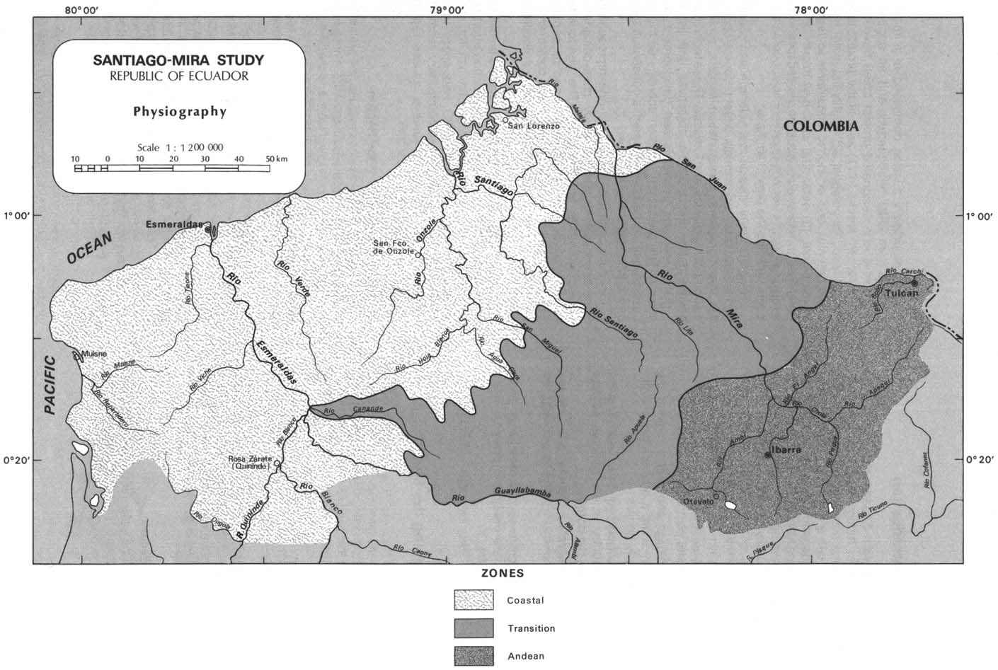
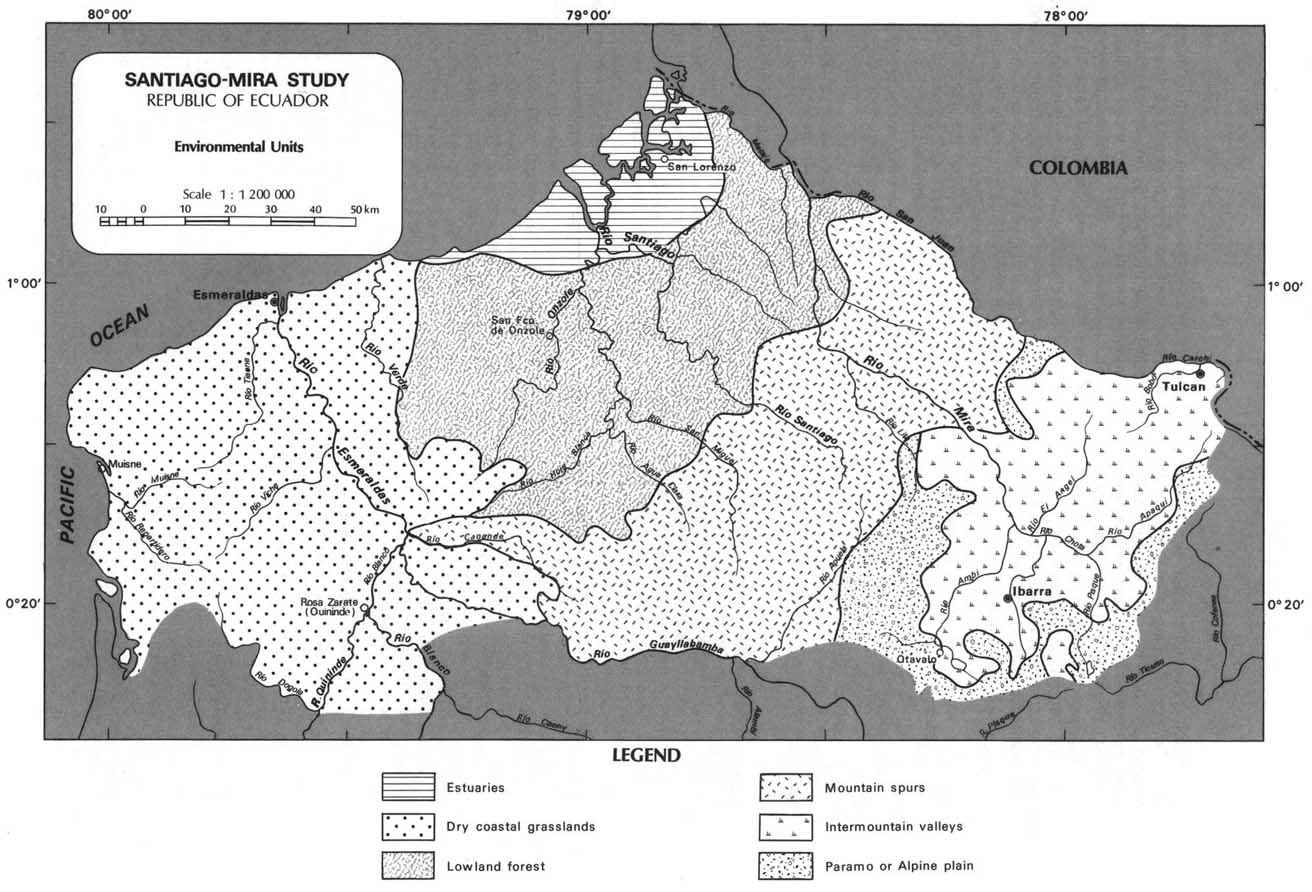
As a result of the discussions in Quito, the preliminary mission concluded that the Santiago-Mira is not a region in socio-cultural or economic terms and that the planning team would have to promote integration among a patchwork of contrasting sub-regions. With this revised goal in mind, the preliminary mission compared the economic, socio-cultural, and demographic features of the three major physiographic units - the Andean zone, the transition zone, and the coastal zone. (See Map 1.)
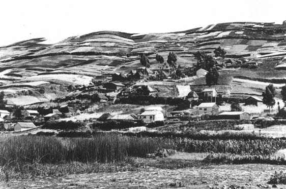
In the ANDEAN ZONE, high population density and related land-use problems were undercutting the area's natural resource potential. Rural settlements in this ethnically diverse zone were supported by agricultural production. Scarce resources had been over-exploited, and limited water resources were managed with a complex system involving groundwater extraction and irrigation. In some areas, salinization was becoming a problem, and pesticide/herbicide run-off from agriculture threatened the region's lakes.
Despite these problems, the Andean was the most prosperous zone. Its transportation system (a section of the Pan American Highway that links Quito to Colombia) was good, and its relatively well established institutions provided the region's most complete social services. Yet, "all roads led to Quito," so directing commerce and social services to other parts of the region stood out as a major planning challenge. The regional development plan would have to reduce population density in the Andean zone and create employment in the region's under-populated area.
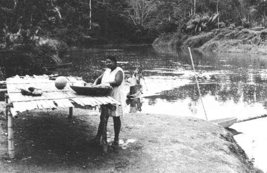
In the COASTAL ZONE, which consists of the lower Mira and Santiago River basins and the lower Esmeraldas River basin, the lack of east-west connections to the Andean zone seriously hampered development. The large port of Esmeraldas had a good connection to Quito but lacked easy access to the north. The northern port of San Lorenzo was isolated from the rest of the region, connected to Esmeraldas only by river and to Ibarra only by a dilapidated railroad.
Geographically, the coastal zone consists of dry tropical savanna on rolling hills to the south and potentially valuable lowlands and wet tropical forests to the north. Vast undeveloped wetlands - seasonally inundated lands, freshwater swamps, mangrove swamps, and an extensive estuary - surround San Lorenzo. In the northern coastal zone, approximately 1,000 farm families are living without title on 300,000 hectares of exhausted forest concessions, principally along the rivers.
Although more data was needed for confirmation, the team tentatively concluded that exploitative concessions and spontaneous colonization were degrading forest resources and impeding proper forest management. The coastal zone's socio-economic problems also turned out to be considerable. The urban centers, Esmeraldas and San Lorenzo, both suffered from significant underemployment, and neither offered adequate social services.
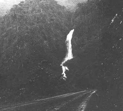
The third subregion, a sparsely populated and relatively undeveloped TRANSITION ZONE between the Andean zone and the coast, consists of steeply sloping forested mountain spurs (estribaciones). At first glance, this zone appeared suitable for hydroelectric development. But basic data were needed to determine whether such development would serve the whole region well and how hydroelectric development in the mountain spurs would affect water-use patterns downstream in the middle and lower Santiago and Mira valleys.
Drawing on their assessments of the region's resource potential and constraints, the preliminary mission spelled out the five main regional planning challenges. First, the study team would identify potential east-west links. To make this possible, JUNAPLA would have to define the region's role in the national economy - a major undertaking. Second, the team would identify projects that improved urban life and also strengthened inter-settlement links. Third, it would collect data on natural resources, socio-economic characteristics, rural-urban links, agricultural and livestock production systems, commerce, and financing. Fourth, it would attune agricultural, livestock, and commercialization programs and policies to the ethnically diverse customs and values of affected populations. Fifth, in the Andean zone, where only modest increases in crop productivity could be expected, the team would find ways to improve the processing, marketing, and distribution of agricultural and livestock products and to boost tourism and artisanal industries.
Opportunities for developing the region's forestry and fisheries resources were plentiful. But significant constraints on their development made collection of baseline data essential before a regional development plan could be drafted.
C. Definition of Study Objectives
Based on the findings of the preliminary mission, the initial study goals were converted into a set of revised objectives for the two-year workplan as follows:
1. Promote internal regional integration by identifying potential economic links between the region and the rest of the country, ways to encourage out-migration from the most densely populated areas, and mechanisms for increasing economic activities in some underdeveloped and sparsely populated areas.2. Increase the region's production, employment opportunities, income, and social services so as to complement the national development plan.
3. Define institutional options for a regional development authority.
4. Produce a model regional plan having potential use elsewhere in Ecuador by rationalizing development activities in relation to one another and to new proposals.
5. Design development projects that use soil, water, flora, and fauna judiciously and that take local cultural and social realities into account.
6. Develop a regional water-management plan for INERHI.
An extra-regional goal was also defined. The Ecuadorian government in its original request for technical assistance had made it clear that frontier integration with Colombia was an important long-term objective. Specific studies of commercial and monetary flow between the two countries, migration of peoples, and other interactions were therefore necessary. The comparative advantage of the Santiago-Mira region was to be evaluated in terms of its potential for trade in agricultural, forest products, and industrial goods with Colombia, and general proposals regarding complementary actions leading to frontier integration were to be developed. Accordingly, informal technical dialog was opened with Colombia early in the study and continued throughout.
Using an interdisciplinary group to define and then reassess the region's core problems entailed benefits that extended throughout the study's diagnostic and plan-formulation phases. No single discipline was allowed to dominate the study perspective, and bringing high-level authorities and the international director into early discussions of objectives simplified execution of the study.
D. Designing the Management Structure
The preliminary mission made both counterpart agencies' interests and objectives explicit at the outset. JUNAPLA, which shouldered responsibility for planning for seven of the country's eight planning regions, wanted an integrated development model of use in other regions. It also wanted to spur the creation of a regional development authority. INERHI's more specific objective was to formulate a national water plan so it could assess each sector's demand for water and set allocation priorities within a regional framework.
The two counterpart agencies' resource commitments differed too. Although JUNAPLA wanted to obtain a finished plan and acquire expertise in preparing regional plans, the agency could not assign a high internal priority or more than limited resources to the study. In contrast, INERHI accorded the highest internal priority to the study, and it could provide more personnel, logistical support, and financing than a planning agency could. For these reasons, INERHI became the principal counterpart.
This arrangement suited both DRD and INERHI in many respects. Since DRD takes a multisectoral approach to technical assistance, the liaison forced INERHI to stretch its institutional mandate and its development vision. At the same time, INERHI's logistical support and commitment to the planning study enhanced DRD's effectiveness. Nevertheless, the preliminary mission, INERHI, and JUNAPLA concluded that the study should capitalize on the strengths and compensate for the weaknesses of both agencies. Weighing the risk that such elaborate administration might pose problems, they agreed that JUNAPLA should serve as coordinator since it could encourage other agencies to cooperate.
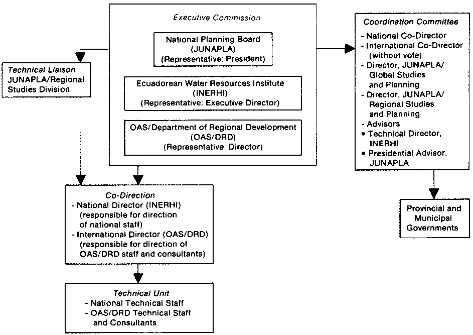
The study would be supervised by an international director (the OAS project chief), the national director (from INERHI), a coordinating committee composed of representatives of all government agencies contributing resources to the study, and an executive commission responsible for making final decisions on the study. (See Figure 1.) INERHI would function as the technical unit, while JUNAPLA would define the regional role and formulate regional development policies. The international director would manage outside consultants while JUNAPLA would guide the national agencies concerned with telecommunications services, road-building, and other sectoral activities.
Figure 1 - ORGANIZATIONAL STRUCTURE
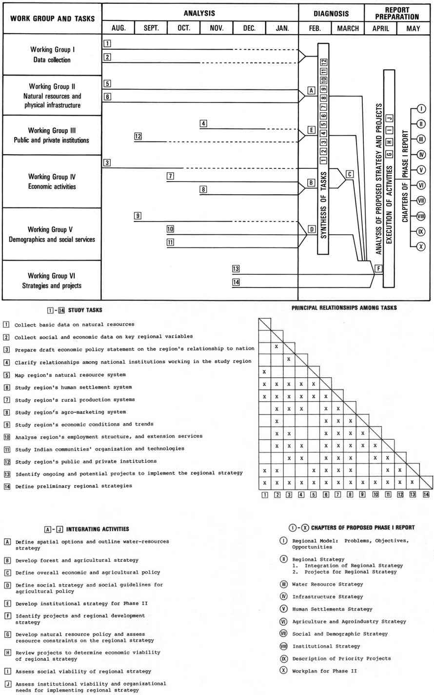
Figure 2 - WORK PLAN MATRIX FOR PHASE I AUGUST 1978 - MAY 1979
E. Workplan Design
Workplan design consisted of three steps: principles for identifying the activities and products of the study were developed; then the project components were identified, and finally the components were sequenced. In step one, the study team used a systems-analysis approach to arrive at these operating principles:
1. A region is an open system that changes as it interacts with external systems. In turn, it is composed of interactive subsystems.2. The main components of the regional system are a physical subsystem composed of natural resources and infrastructural components; an activity subsystem composed of social and economic components; and a regulating subsystem composed of institutions and technological components.
3. The main objective of regional development is to harmonize within a given timeframe the region's internal systems and the interactions of the region with external systems.
In step two, sketch maps and linkage analysis diagrams were used to get a picture of systems interactions, development opportunities, and development constraints. On this basis, 14 study tasks were identified, each geared toward a well-defined product.
Step three took place in three successive approximations. First, the study components and study outputs were simply listed to identify discrepancies. Time, the availability of information, and technical constraints were introduced and all the incompatibilities between desired products and operational constraints became evident. Finally, when the team had worked out these problems, the study's constraints and objectives were related to the 14 study tasks.
On the basis of the final workplan matrix, six working groups were created. Group I was assigned to cover data collection; Group II focussed on natural resources and physical infrastructure; Group III on public and private institutions; Group IV on economic activities;
Group V on demographic and social services; and Group VI was charged with developing the regional strategy and coming up with the project proposals. The tasks assigned to the groups were defined in terms of specific zones, sectors, and integrating activities. The team also linked tasks to each other. Team members could easily see who they would have to collaborate with on each task, as well as how the tasks related to each other.
Figure 2 shows the main study tasks and integrating activities conducted to produce the final report of Phase I. The legend of Figure 2 shows the principal relationships among the tasks. The original matrix showed when each of these interactions would take place, but this simplified version does not show these connections graphically. The figure demonstrates that a constant and planned interaction took place among the technical components during the execution of the tasks. Results of the tasks were integrated in combinations designed to yield conclusions on specific strategies and projects. A synthesis of all the tasks was completed to arrive at an overall development strategy and a package of projects for the region. Finally, the proposed strategy and projects were analyzed in terms of their physical, economic, social, and institutional feasibility (Integrating Activities G, H, I and J in Figure 2.) The process facilitated the preparation of a final report.
In effect, this two-week diagnosis of the region's development opportunities and constraints was a second and lengthier iteration of the quick analysis made by the preliminary mission. Although the exercise may appear academic, it was, in fact, practical. It minimized "downtime" and confusion among team members, acted as a check against false expectations, limited the number of issues the study team addressed, fostered teamwork, and helped insure project momentum.
These broad tasks were divided into 104 specific tasks. Instead of open-ended data-gathering efforts, all were directed at answering specific questions, filling data gaps, and confirming or rejecting hypotheses. For each task, the basic information, analyses, and publications each technician would have to prepare were specified.
Next, the team developed sub-matrices for analyzing actual and proposed development activities in the context of the support activity and regulating systems mentioned above, With these tools, the team could see, for example, that excessive socio-economic pressures made further development of irrigated agriculture in the Andean zone unwise, Similarly, in the coastal zone, it discovered both underutilized support-system capacity and institutional constraints on some types of development.
These sub-matrices were combined into a larger matrix to identify analytical gaps on current and potential conditions and systems interactions. This aggregated matrix also served as the basis of sequencing study activities, step three.
The study was conducted in two phases. In Phase I, the region's resource problems and potentials were assessed. In Phase II, a regional development plan was prepared and projects for implementing the plan were formulated.
A. Phase I - Activities of the Working Groups
The specific concerns of the five working groups created to carry out the 14 tasks defined during work-plan preparation were:
Group 1 (Data Collection and Survey of Existing Projects). Existing mapping and aerial photographic coverage, data on urban and rural settlements, relevant legislation, demographic statistics, and investment projects planned or under way.Group 2 (Support Systems Study - Natural Resources and Ecosystems). Soils, forest resources, geology, fish resources, water use management, and "environmental units," (See Glossary.)
Group 3 (Regulating Systems Study - Economic and Institutional Features). Physical and social infrastructure, institutional structure, and other economic factors.
Group 4 (Activity System Studies - Sectoral Activities), Agriculture, animal husbandry, and forestry.
Group 5 (Regional Strategy and Project Proposals). Regional development, programs, and projects. (This group also prepared the interim report.)
On the basis of these analyses, a thorough review of Ecuador's National Development Plan (which was conducted to determine the region's role in national development and the impact nationwide development programs would have on the region), and the natural resource inventory described below, the study team refined the development objectives and strategies on which the regional development plan would be based. Specifically, it decided to devote further study primarily to agriculture, livestock production, forest-based economic activities, fishing, hydroelectric development, tourism, and general development obstacles. Obvious socio-economic constraints included severe underemployment, limited markets, low capacity for productive investment, lack of social services and institutional coordination, a rigid social structure, and illiteracy. The major physical constraints included uneven topography and the inaccessibility of the extensive mountain spurs and the humid lowland forests.
B. Phase I - The Natural Resource Analysis
The natural resource analysis conducted during Phase I took relatively little time. But since it significantly affected the study team's recommendations, it warrants detailed discussion here,
1. The Classification Matrix
Early in the Santiago-Mira study, the team's natural resource specialist conducted a field survey of the study area's major ecosystems and drew up a report for the other team members' use. After three weeks in the field with an Ecuadorian counterpart, the specialist mapped eight "environmental units" on a life-zone map. (See Glossary.) These included (1) the high Andean grasslands (the paramo or alpine plain), (2) the densely populated intermountain valleys, (3) the mountain spur forests between the sierra and coast (estribaciones), (4) the humid lowland tropical forests, (5) the dry tropical grasslands on the coast, (6) the freshwater swamps and mangrove swamp forests that make up the Rio Santiago's extensive estuary, (7) lakes and rivers, and (8) sea and beaches. (See Map 2 and Table 1.)
Using this classification system, the natural resource specialist identified the potentials, constraints, and interrelationships of the natural components and processes of the major ecosystems. He briefly characterized the climate, vegetation, and the other principal resources of each unit and then analyzed the natural goods and services (see Glossary) available from each. (See Table 2.) Such goods and services include:
1. Those that have economic, social, or cultural value (such as lumber from forests, tourism potential, or archeological interest);2. Those that have scientific value (such as plant and animal resources for which future uses can be expected to be found); and
3. Those that regulate ecosystem functioning (such as nutrient or water storage).
To list the goods and services for the environmental units, the natural resource specialist consulted with all the study team's other members. Instead of trying to quantify all the natural goods and services in each environmental unit, he simply indicated the features of the natural system, leaving it to planners, sectoral specialists, and decision-makers to determine the relative importance of each for their purposes.
The next step was to determine the impacts various development activities would probably have on the availability of the region's natural goods and services. Impacts were categorized as (1) immediate negative impacts, (2) immediate positive impacts, (3) future negative impacts, (4) future positive impacts, (5) a mixture of positive and negative impacts, and (6) unknown impacts. (See Table 3.)
The analysis of the mountain spur forests centered on the impacts the six most likely types of development (forestry, agricultural colonization, livestock production, road-building, hydroelectric development, and the creation of forest reserves) would have on the environmental unit's goods and services. The project team concluded that forestry development would affect most natural goods and services negatively, although it would have a positive short-term impact on firewood and lumber production. Road-building activities would have both positive and negative long-term effects: positive on scenic tourism and agricultural production potential, but negative on flood control, erosion control, wildlife habitat preservation, and other natural goods and services associated with the intact forest.
In contrast, creating extensive ecological reserves in this zone would ensure the long-term health and availability of most of its natural goods and services. With this approach, less grazing land, firewood, lumber, and game meat would be available, but flood-control, water-storage, aquifer-recharge, erosion control, tourism, recreation, fisheries conservation, and wildlife conservation functions would be preserved.
Table 1 ILLUSTRATIVE FINDINGS FOR SELECTED ENVIRONMENTAL UNITS
|
|
INTERMOUNTAIN VALLEYS |
HIGH-MOUNTAIN GRASS LANDS (PARAMO OR ALPINE PLAIN) |
MOUNTAIN SPUR FORESTS (ESTRIBACIONES) |
|
a. Character |
· Precipitation variable. |
· Elevation: above 3,200 m. |
· Elevation above 500 m; slopes of the western cordiliera |
|
b. Natural Goods and Services |
· River water available for drinking, irrigation, industrial uses. |
· Source of water: snow melt for drinking and industrial use. |
· Storage of precipitation, regulation of water regime downstream. |
|
c. Current or Proposed Uses |
· Urbanization, agriculture, and livestock production have greatest impact. |
· Extensive livestock grazing, which typically leads to over-grazing, resulting in degraded soils and gradually declining pasture quality. |
· Proposed colonization and agricultural development projects will reduce the capacity of this ecosystem to store and regulate water flows and will cause Increased sedimentation and erosion. These phenomena could have costly effects on the port of Esmeraldas (sedimentation) or the airport of Esmeraldas (threatened by river bank erosion). |
|
d. Recommended Uses |
· Control conversion of good cropland to urban development. |
· Strictly control livestock grazing. |
· Creation of an ecological reserve would allow wildlife to recover and allow vegetation to recover (stopping erosion and increasing the land's capacity to control water flow, particularly floods). |
Table 2 - NATURAL GOODS AND SERVICES
|
GOODS/PRODUCTS | |
|
|
1. Potable water (surface and ground) |
|
|
2. Industrial water (surface and ground) |
|
|
3. Irrigation water (surface and ground) |
|
|
4. Lumber and pulpwood |
|
|
5. Firewood |
|
|
6. Construction materials from wood (post, beams, etc.) |
|
|
7. Ornamental plants (Indoor, landscaping, dry) |
|
|
8. Vegetable fibers (rope, cloth) |
|
|
9. Medicinal plants |
|
|
10. Food for human consumption (fruits, gum, honey, sap, shoots, seeds, nuts, leaves) |
|
|
11. Food for human work, animal consumption |
|
|
12. Food animals for human consumption (fish, fowl, etc.) |
|
|
13. Aquatic plants for human consumption (algae, sponges) |
|
|
14. Food condiments (spices, salt, bicarbonate of soda) |
|
|
15. Plant chemical substances (dyes, stains, waxes, latex, gums, tannins, syrups, drugs, etc.) |
|
|
16. Fertilizers (minerals, fishmeal, guano, other dung, etc.) |
|
|
17. Aquatic precious/semiprecious materials (pearl, coral, conchs, mother of pearl) |
|
|
18. Materials for artisan work (rock, wood for carving, fibers for basketmaking, etc.) |
|
|
19. Metallic minerals (bauxite, ores, nuggets, etc.) |
|
|
20. Non-metallic minerals (asbestos, clays, limestone, etc.) |
|
|
21. Construction materials (sands, clay, cinders, cement, gravel, rocks, marble, etc.) |
|
|
22. Mineral nutrients (phosphorus) |
|
|
23. Mineral dyes and glazes |
|
|
24. Hides, leather, skins |
|
|
25. Other animal materials (bones, feathers, tusks, teeth, claws, butterflies) |
|
|
26. Other vegetation materials (seeds, pods) |
|
|
27. Live fish (ornamental, pets) |
|
|
28. Live animals for pets and zoos |
|
|
29. Live animals for human work |
|
|
30. Live animals for research |
|
|
31. Fossil fuels (crude oil, natural gas, coal) |
|
|
32. Other fuels (peat, other organic matter, dung, biomass) |
|
|
33. Livestock forage |
|
ECOSYSTEM OPERATIONS, MAINTENANCE, ADAPTATION, AND EVOLUTION | |
|
|
1. Nutrient cycling |
|
|
2. Nutrient storage |
|
|
3. Nutrient distribution (floods, dust and sediment transport, etc.) |
|
|
4. Photosynthesis-respiration |
|
|
5. Adaptation |
|
|
6. Self-regulation |
|
|
7. Competition testing and design (population control evolution) |
|
|
8. Mineral cycling |
|
|
9. Habitat for local land, air, aquatic animals, Insects, and other life forms (feeding, breeding, nursery, shelter, etc.) |
|
NON-TANGIBLE GOODS AND SERVICES | |
|
|
1. Windbreak |
|
|
2. Shade |
|
|
3. Recreational use of water (swimming, boating, skating, water skiing, sailing, surfing, scuba) |
|
|
4. Recreational use of land (hiking, spelunking, climbing) |
|
|
5. Recreational use of air (flying, gliding, parachuting, kiting) |
|
|
6. Recreational use of animals (sport hunting and fishing, insect collecting) |
|
|
7. Recreational use of ecosystem (sightseeing, tourism) |
|
|
8. Scientific tourism (exploring) |
|
|
9. Value development and storage |
|
|
10. Spiritual development and storage |
|
|
11. Historical value |
|
|
12. Cultural value |
|
|
13. Early warning system (weather and climate change) |
|
|
14. Moisture modification (humidity) |
|
|
15. Temperature modification |
|
|
16. Light modification |
|
|
17. Ultraviolet and other radiation filtration |
|
|
18. Storage of life form adaptive (genetic) Information |
|
|
19. Protection of Indigenous cultures and customs |
|
ECONOMIC SERVICES | |
|
|
1. Energy sources (wind, solar, hydro, tides, biomass, geothermal) |
|
|
2. Dilution of contaminants |
|
|
3. Decomposition of contaminants (oxidation, evaporation, dissolution) |
|
|
4. Transport of contaminants (wind, water, animal consumption, air and watershed dilution of contaminants) |
|
|
5. Erosion control |
|
|
6. Sediment control |
|
|
7. Flood control |
|
|
8. Ground water recharge |
|
|
9. Space for urban, Industrial, agriculture occupations, roadways, canals, airports |
|
|
10. Waste and contaminant storage |
|
|
11. Physical support for structures |
|
|
12. Climate control and protection |
|
|
13. Disease control and protection |
|
|
14. Storm buffer |
Table 3 - DEVELOPMENT IMPACTS ON THE GOODS AND SERVICES OF THE MOUNTAIN SPURS ENVIRONMENTAL UNIT
|
|
ACTUAL AND PROPOSED ACTIVITIES | |||||
|
NATURAL GOODS AND SERVICE |
FOREST EXPLOITATION |
COLONIZATION (AGRICULTURE) |
COLONIZATION (LIVESTOCK) |
HIGHWAYS |
ECOLOGICAL RESERVE |
HYDROELECTRIC DAM IN UPPER (INDUSTRIAL) WATERSHED |
|
Hydroelectric Energy Resources |
|
|
|
|
|
|
|
Edible Plants |
? |
|
|
- |
|
- |
|
Flood Control |
|
|
|
|
|
|
|
Erosion Control |
|
|
|
|
|
- |
|
Wildlife Habitat (Terrestrial and aquatic fauna) (Nursery, breeding, shelter, feeding) |
|
|
|
|
|
|
|
Gene Bank (Animal) |
|
|
|
- |
|
- |
|
Gene Bank (Vegetable) |
|
|
|
- |
|
- |
|
Preservation of Endangered Species |
|
|
|
|
|
|
|
Leather and Skins |
? |
|
|
- |
|
- |
|
Scenic Tourism |
|
|
|
|
|
|
|
Scientific Tourism |
|
|
|
|
|
|
|
Spiritual Value |
|
|
|
|
|
|
|
Scientific Value |
|
|
|
|
|
|
|
Nutrient Storage |
|
|
|
- |
|
- |
|
Nutrient Cycling |
|
|
|
- |
|
- |
|
Water Storage |
|
|
|
|
|
|
|
Ground Hater Recharge |
|
|
|
- |
|
|
|
Dilution of Water Contaminants |
|
|
|
- |
|
- |
|
Lumber |
|
|
|
- |
|
|
|
Fuelwood |
|
|
|
- |
|
|
|
Vegetable Fibers |
|
|
|
- |
|
- |
|
Ornamental Plants |
|
|
|
- |
|
- |
|
Regulation of Ecosystems (Fauna) |
|
|
|
- |
|
- |
|
Regulation of Ecosystems (Vegetation) |
|
|
|
- |
|
- |
|
Edible Fauna |
|
|
|
- |
|
- |
|
Fishing |
|
|
|
- |
|
|
|
Live Animals for Pets |
|
|
|
- |
|
- |
|
Live Animals for Medical Research |
|
|
|
- |
|
- |
|
Tourism and Sport Hunting |
|
|
|
- |
|
- |
|
Metalic Minerals |
? |
? |
? |
? |
? |
|
|
Industrial Water |
|
|
|
|
|
|
|
Construction Materials (Vegetative) |
|
|
|
- |
|
- |
|
Plant Chemical Substances |
|
|
|
- |
|
- |
|
Medicinal Plants |
? |
? |
|
- |
|
- |
|
Feathers |
|
|
|
- |
|
- |
|
Ornamental Fish (Pets) |
|
|
|
|
|
|
|
Cultural Value |
|
|
|
|
|
|
|
Non-Vegetative Construction Materials |
? |
? |
? |
? |
- |
|
|
Agricultural Production |
|
|
|
|
|
|
|
Endangered Plant Species |
? |
|
- |
- |
- |
|
Keys.:
Immediate Negative Impact
Immediate Positive Impact
Future Negative Impact
Future Positive Impact
? Unknown Impact
Complex of Negative and Positive Impacts. r
The Andean region turned out to have more development potential than the mountain spur forests. In the valleys, irrigation projects, urban growth, industrialization, reforestation, and livestock development were options. Urban growth, industrialization, and livestock development would all have both long-and short-term negative effects since the region was already densely populated and some resource-management practices were already in use. But reforestation, animal husbandry, and assistance projects afforded both immediate and long-term benefits, including the reversal of the resource degradation. Irrigation in this area of limited water supply would have both negative and positive impacts: while it would enhance agricultural production, pastureland, fisheries, and flood control, it would also decrease the amount of water available for hydropower development and exhaust the water resource's capacity to dilute agricultural pesticides and other contaminants.
2. Review of Existing Project Proposals
Besides characterizing the area's environmental units, the natural resource specialist evaluated several large projects that national agencies had proposed for the region. Using a sector-by-sector list the study team had prepared on the advice of the programming mission, the specialist located both proposed and existing development projects on a regional map before assessing how each major project would reduce or increase the region's potential for other development opportunities.
For example, proposals for hydroelectric projects in the mountain spurs appeared sound by traditional measures - the vertical drop of the rivers and the volume of flow resulting from precipitation. However, roads for construction and maintenance crews would have to be built before dams and power-generating plants could be constructed. Moreover, road-building would probably give rise to spontaneous colonization, and in this zone of steep slopes and high rainfall, lands cleared by settlers would quickly lose their topsoil and contribute to sedimentation in the lower valleys. A second major drawback to hydroelectric projects would be possible estuary damage. Although a properly managed estuary at the mouth of the Rio Santiago around San Lorenzo could support recreation, additional commercial and artisanal fisheries, and tourism, the natural water regime would be upset if hydroelectric development occurred upstream and other development activities led to deforestation in the mountain spurs.
The natural resource specialist specified the data that would have to be collected on the relations between the mountain spur forests and the estuary before all the costs and benefits of hydropower development in the region could be calculated. In the case of a proposed road that would have caused erosion, he suggested an alternative route that would entail less damage to the ecosystem. He also proposed abandoning plans for shrimp-farming development that involved capital-intensive artificial tanks, and recommended improving management of estuarine shrimp production under natural conditions instead.
Identifying and analyzing such trade-offs early in the planning sequence led to tremendous savings, whether through substituting better alternatives or abandoning projects that would eventually prove unworkable. Overall, the idea was not to halt development but to guide investment toward the best all-round development alternatives - those that offer the greatest returns over time without exhausting the resource base.
3. Conflict Identification and Resolution
To uncover potential resource use conflicts in Santiago-Mira, the natural resource specialist constructed a matrix arraying development sectors along both axes. With respect to each cell in the matrix, he asked "What will be the effect of activity (x) on activity (y)?" For each important conflict, he gave a tentative answer. This exercise helped planners decide initially which resources could be intensively exploited at acceptable costs and which could not.
Table 4 is a partial matrix analysis of the extensive coastal estuary around San Lorenzo. On this matrix, sectoral overlaps indicate potential conflicts, For example, fisheries development in the estuary might impinge upon forestry activities since the mangroves would have to be at least partially cleared to make way for shrimp farms. Alternatively, most of the mangroves would have to be preserved to permit other types of marine life to reproduce. By the same token, forestry sector activities could impinge upon fisheries activities if mangrove harvesting were undertaken at the expense of fish and shrimp habitats.
To construct this matrix, the natural resource specialist sounded out other team members, counterparts in various sectoral agencies, and local citizens. To identify the full range of direct and indirect impacts of development activities, he asked members of both the "target population" and those who could be inadvertently affected what changes they would recommend in the proposed development.
The report also identified the dry tropical portion of the coastal zone as the region's best ecosystem for livestock production and recommended improving the use of trained personnel to increase food and meat production in the Andean valleys. Highest priority was assigned to technical assistance, credit mechanisms, and the development of provincial urban centers.
The report's management proposals emphasized the importance of integrating and coordinating development activities. Besides strengthening existing physical, economic, and social links within the region, the study team recommended closely coordinating sectoral activities and national, regional, and local initiatives.
Table 4 - MATRIX OF POTENTIAL INTER-SECTORAL IMPACTS AND CONFLICTS OVER RESOURCE USE IN THE ESTUARY AT SAN LORENZO
|
Impact on: Activities |
Fisheries Activities |
Forestry Activities |
Transport Infrastructure |
|
Fisheries Activities |
1,2 |
3,4 |
5 |
|
Forestry Activities |
6 |
|
|
|
Transport Infrastructure |
7 |
|
8 |
Impacts of Fisheries Development on Natural Fisheries:
1. Shrimp farming reduces natural fish populations by destroying breeding and nursery habitat.2. Shrimp farming reduces natural shrimp populations through habitat destruction and larvae collection.
Fisheries Activities on Forestry Activities:
3. Shrimp farming reduces mangrove forests available for other types of exploitation.4. Natural fisheries require conservation of mangrove forests for fish nurseries, prohibiting mangrove exploitation.
Fisheries Activities on Transport:
5. Conservation of fisheries breeding areas requires that roads be rerouted or built much more expensively (i.e., with culverts to allow free passage of water).
Forestry Activities on Fisheries Activities:
6. Extensive logging of mangrove forests reduces shrimp and fish habitat.
Transport Sector Development on Fisheries Activities:
7. Certain types of road construction (e.g., without culverts) destroys fisheries by impeding water flow. For example, formerly brackish areas can turn freshwater or saline.
Transport on Transport:
8. A new road constructed above the railroad along steep slopes in highly erodible areas can significantly increase the railroad's maintenance costs.
Another recommendation was to capitalize on under-exploited forest resources, though not without first studying the probable impacts of greater exploitation. Since the forestry laws were not enforced and the forest administration could not manage a major forestry development program, the study team recommended making improved administration, forest management, and development a national priority. Doing so would entail increasing autonomy, funds, and personnel for the forest department and coordinating its activities with those of the Agrarian Reform and Colonization Institute.
The natural resource specialist also proposed integrating an "environmental quality objective" with the study's other, more conventional goals to help insure that development activities do not unnecessarily foreclose future options and that the welfare of all populations affected by the project would be taken into account.
4. Conclusions and Recommendations of the Natural Resources Working Group
The Santiago-Mira study's environmental report summarized the region's opportunities and development constraints. It also set forth a broad range of recommendations, including management options.
Specifically, the report called attention to the economic importance of the estuary of Limones and San Lorenzo: already a habitat for many coastal marine species and a breeding ground for deep-sea species, it could also supply food for local, regional, and national markets. Because the estuary's fresh water comes from the humid forests in the mountain spurs, the report called for further research on the estuary's relation to upland forests and swamps, the nature of the water regime, and its role in the life cycles of major estuarine species. It also recommended identifying all commercially valuable estuarine species and strictly regulating the use of the mountain spurs, humid lowland forests, and swamps until the economic potential of the estuarine fisheries was assessed.
For the humid tropical forests of Esmeraldas, the study team recommended sustained forest production instead of clear-cutting for agricultural or livestock development. It also recommended developing river transport. Although canals would have to be built and transportation cooperatives set up to finance and maintain motor boats, a river transport system would be less likely than a road system to open the area up to uncontrollable colonization.
Phase I culminated in the production of 32 sectoral reports reviewed and published by JUNAPLA and integrated into a synthesis document, Bases for the Development of Region I.
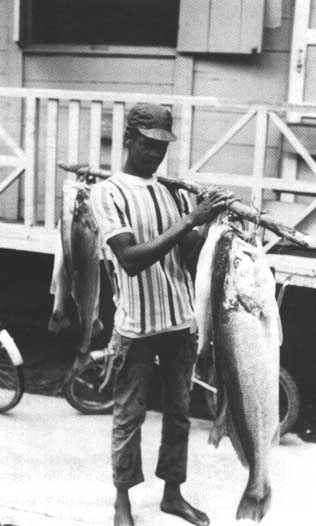
The estuary of Limones and San Lorenzo is an important breeding ground for these deep sea species.
C. Phase II - The Regional Development Strategy
For Phase II, 13 working groups were established. They covered the regional development strategy, the water use plan, institutional arrangements, the mining program, the feeder-road program, agricultural projects, the forest-industries development program, forestry projects, agro-industry projects, irrigation projects, the housing program, the education plan, and final report preparation. The groups' first task was to select the program and project proposals most likely to serve JUNAPLA's overall objectives for the region. The selection was based on a thorough examination of likely economic and social costs and benefits. Next, a four-year investment plan (1980-84) for the projects that fared best in this comparative analysis was developed. This report was submitted to JUNAPLA for review and forwarded to other national sectoral agencies for use in creating sectoral projects for the region.
With the investment plan completed, the study team decided which parts of the study would have to be subcontracted. INERHI hired the Military Geography Institute to take aerial photographs of the region, the National Regionalization Planning Agency (PRONAREG) to study the Santiago River basin, and the Center for Planning and Social Research (CEPLAES) to undertake anthropological studies in the region's rural communities. Other agencies were contracted to diagnose the tourist industry, the manufacturing sector, and regional institutions. Throughout, JUNAPLA coordinated and reviewed all public sector activities.
At the end of Phase II, JUNAPLA and the interdisciplinary groups prepared a report on the proposed development strategy program proposals. The projects in these programs were developed to the pre-feasibility level. (See Glossary.)
D. Phase II - The Final Report
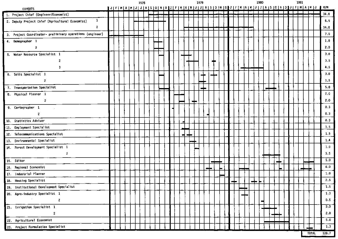
The Santiago Mira study took three years to complete and involved 128.7 person-months of OAS specialists and 520 person-months of Ecuadorian counterparts. (The sequence of participation of OAS specialists is shown in Figure 3.)
The final report contained sector assessments, the full-blown regional development plan, and 110 project proposals grouped in five programs: (1) basic government conservation and research services, (2) integrated rural development and colonization, (3) direct production, (4) economic infrastructure, and (5) social infrastructure.
Agricultural and livestock production held out the most development potential for the region as a whole, though the "agricultural frontier" was nearly exhausted in the densely populated Andean valleys. To increase the yields on currently used lands, the project team recommended investing in training related to the introduction of improved technologies, In Esmeraldas, where productive land could be increased significantly, livestock production could be intensified by raising sheep instead of cattle.
The forestry sector was discussed as a potential source of new jobs. In addition, a river-transport system was proposed to make Esmeralda's chief forest resources accessible.
Three recommendations were put forth for developing the region's considerable coastal, pelagic, and interior fisheries. In the coastal area, new industries for processing, packaging, and distributing fisheries products could be developed. In the Andean zone, such profitable fish as trout could be introduced to help meet the area's food needs and relieve the pressure on agricultural land. The third recommendation was to offer specialized fisheries-management training, credit, and financial support to fishermen.
Since no systematic and comprehensive studies on the area's fisheries, forestry, and mining sectors were available, the report called for additional data on these resources. Besides data gaps, it also identified other development constraints: severe under-employment, limited markets, low regional capacity for investment, limited economic integration among the provinces, a rigid social structure, illiteracy, lack of coordination among regional and national institutions, and lack of regional planning.
The refined version of the regional development plan reflected JUNAPLA's conviction that the region should exploit those resources that give it a comparative advantage over the rest of Ecuador. More specifically, JUNAPLA had determined that (1) the regional GNP should increase at a rate slightly higher than the national GNP (7.3 percent vs. 6.5 percent); (2) the agriculture, livestock, fisheries, mining, and transport sectors should grow especially rapidly compared to these sectors' growth in the rest of the country; (3) regional employment should grow by 4.2 percent (versus 4 percent elsewhere in Ecuador); and (4) development in the region should contribute to border integration with Colombia and strengthen both inter-and intra-regional economic links.
Each of the development projects identified in the final plan was analyzed in terms of its costs, benefits, and relationship to 11 more general regional development objectives set forth by JUNAPLA:
1. Improve the population's standard of living.2. Redistribute income.
3. Increase the regional GNP.
4. Save foreign exchange.
5. Create jobs.
6. Improve the utilization of natural and human resources.
7. Develop human resources.
8. Improve socio-economic organization and increase the population's participation in development activities.
9. Support rural development.
10. Improve integration within the region and also between the region and the national economy.
11. Increase linkage among sectoral activities within the region.
In the final plan, the time-frame, location, cost, and agency responsible for each project were also specified. The availability of internal and external financing for each project was assessed along with the possibility of using the same source to finance multiple projects serving one development objective.
The study team recommended investing US$984 million in the region between 1981 and 1984. (See Table 5.) The largest investment, 40 percent of the total, was allocated to developing port facilities, a road system, telecommunication services, energy and rural electrification projects, irrigation systems, and other infrastructure. Since regional integration, rural-urban income redistribution, and the development of provincial urban centers were major project goals, roads were accorded the highest priority.
Figure 3 - CHRONOGRAM OF INTERNATIONAL TECHNICIAN ACTIVITIES
Table 5 - INVESTMENT PROPOSALS (1981 US dollars) ($1,000)
|
PROGRAMS AND PROJECTS |
UP TO 1980 |
1981 |
1982-1984 |
Total 1981-1984 |
% | |
|
1. BASIC GOVERNMENT RESEARCH ON CONSERVATION |
134.1 |
1,674.3 |
10,116.2 |
11,790.5 |
1.20 | |
|
|
1.1 Conservation of Forest and Wildlife |
134.1 |
1,554.3 |
7,870.4 |
9,424.6 |
0.96 |
|
|
1.2 Research on Mineral Resources |
- |
120.0 |
2,245.8 |
2,365.8 |
0.24 |
|
2. MULTISECTORAL DEVELOPMENT IN SPECIFIC AREAS |
2,760.0 |
1,566.0 |
25,162.0 |
26,728.0 |
2.72 | |
|
|
2.1 Integrated Rural Development |
2,760.0 |
1,074.8 |
24,653.2 |
25,728.0 |
2.61 |
|
|
2.2 Colonization |
- |
491.2 |
508.8 |
1,000.0 |
0.10 |
|
3. PRODUCTION SECTORS |
6,012.0 |
26,845.2 |
154,045.1 |
180,890.3 |
18.38 | |
|
|
3.1 Livestock and Agriculture |
40.0 |
- |
13,135.0 |
13,135.0 |
1.33 |
|
|
3.2 Agroindustry |
42.0 |
- |
180.0 |
180.0 |
0.02 |
|
|
3.3 Forests and Related Industries |
6,020.0 |
4,000.0 |
102,080.0 |
106.080.0 |
10.78 |
|
|
3.4 Fishing and Related Industries |
- |
1,800.0 |
16,000.0 |
17,800.0 |
1.81 |
|
|
3.5 Industry and Crafts |
- |
245.1 |
|
245.2 |
0.02 |
|
|
3.6 Oil and Natural Gas |
- |
20,000.0 |
15,000.0 |
35,000.0 |
3.56 |
|
|
3.7 Tourism |
- |
800.0 |
7,650.0 |
8,450.0 |
0.86 |
|
4. ECONOMIC INFRASTRUCTURE |
5,581.5 |
34,180.4 |
357,874.9 |
392,055.3 |
39.85 | |
|
|
4.1 Ports |
1,400.0 |
2,800.0 |
16,600.0 |
19,400.0 |
1.97 |
|
|
4.2 River Transport |
- |
- |
12.0 |
12.0 |
0.01 |
|
|
4.3 Irrigation |
4,724.0 |
672.0 |
5,708.9 |
6,380.9 |
0.65 |
|
|
4.4 Telecommunications |
800.0 |
1,172.0 |
11,260.0 |
12,432.0 |
1.26 |
|
|
4.5 Population and Market Centers |
- |
- |
800.0 |
800.0 |
0.08 |
|
|
4.6 Energy and Rural Electrification |
36,942.8 |
10,900.0 |
122,537.0 |
123,437.0 |
12.55 |
|
|
4.7 Primary Roads |
8,780.2 |
10,092.0 |
123,949.6 |
134,041.6 |
13.62 |
|
|
4.8 Secondary Roads |
590.2 |
5,654.0 |
81,655.2 |
87,309.2 |
8.87 |
|
|
4.9 Urban Infrastructure |
2,644.2 |
2,890.4 |
5,352.0 |
8,242.4 |
0.84 |
|
5. SOCIAL INFRASTRUCTURE |
57,540.5 |
77,900.6 |
294,547.6 |
372,448.2 |
37.85 | |
|
|
5.1 Housing |
12,109.3 |
18,162.8 |
90,957.1 |
109,119.9 |
11.09 |
|
|
5.2 Potable Water and Sewers |
5,383.5 |
6,724.0 |
9,628.0 |
16,352.0 |
1.66 |
|
|
5.3 Education and Training |
36,017.7 |
39,176.9 |
170,264.5 |
209,441.4 |
21.29 |
|
|
5.4 Health |
4,030.0 |
11,340.0 |
16,418.0 |
27,758.0 |
2.82 |
|
|
5.5 Community Building and Social Welfare |
- |
2,496.8 |
7,280.0 |
9,776.8 |
0.99 |
|
TOTAL |
122,418.1 |
142,166.4 |
841,745.7 |
983,912.1 |
100.0 | |
The second largest investment, 38 percent, was allocated to developing regional social infrastructure - new housing and structural rehabilitation, improved drinking-water supply, improved health services, and increased training and educational opportunities. Of these, education and training received the most funds (21 percent of the total investment) since illiteracy and lack of training reinforced the region's high rate of unemployment. Housing (which received 11 percent of the total investment) was also stressed since the programming mission and the study team concurred that the grave lack of urban social services and infrastructure in the region undermined the region's economic development.
Another major investment (10.8 percent) proposed was for forestry development to create new jobs and to increase local income. The report emphasized the economic value of the region's substantial humid lowland tropical forest and the importance of strengthening the Ecuadorian Forestry Department.
The Santiago-Mira project's final report was presented to the Government of Ecuador in May of 1981. One year later, a DRD staff member assessed the impact of the plan by interviewing officials in the two former counterpart agencies and in other collaborating agencies. The results of that assessment follow.
A. The Regional Development Authority
The understanding at the outset of the study was that either during or soon after the study a new regional development authority would be created for the region containing the Santiago-Mira basins. One project goal was, in fact, to work closely enough with provincial and municipal authorities to gain their active support for creating such an entity.
In 1978, when project negotiations started, interest in regional development planning was particularly strong in Ecuador. The United Nations Development Programme had helped JUNAPLA design a regional planning system and divide the country into eight development planning regions, There was considerable enthusiasm for regional planning in the Santiago and Mira basins as a pilot effort, and JUNAPLA expressed great interest in DRD's use of resource evaluation as the basis for integrated regional development planning.
One year after the plan was published, the regional authority had not yet been created. JUNAPLA continued to promote such an entity, but at the regional level the lack of agreement on the seat of the authority had slowed progress. The three provincial capitals all wanted to be the seat, and they had been unable to negotiate a compromise. Nevertheless, intense lobbying indicated strong regional interest. In mid-1982, negotiations focussed on safeguards to ensure that the regional seat would distribute regional development funds to the other provinces.
B. Progress to Date
It is too early to tell whether the regional plan will be implemented. INERHI had the study hand-delivered to all the sectoral agencies involved in project identification and formulation, but INERHI itself is taking responsibility for implementing only the water projects. On the other hand, the study has been an unqualified success as a spur to institution-building. The study was designed to break down workplan preparation into manageable serial tasks, starting with data collection and proceeding to increasingly analytical and integrative components. Because all the plan's components had been conceptualized in fine detail, effective terms of reference could be written for the many consultants who joined the study temporarily. Consequently, INERHI plans to design future studies in the same way.
Many project proposals were implemented between mid-1981 and mid-1982. INERHI moved ahead on five of the seven irrigation projects proposed, and the Ministry of Public Works, the Transport Division, the Ministry of Agriculture, and the National Housing Board (JNV) began to execute several of the first-year projects proposed in the plan. Budget cuts had kept both the Ministry of Public Works and JNV from executing more, but the agencies were optimistic about the coming year's budget. In JNV, staff members were routinely using the study's methodology for designing regional housing programs.
As for the study's goal of better integrating the border between Colombia and Ecuador, several factors augur well. This is one of the world's most open borders, with people and goods flowing in both directions and discord almost unknown. Moreover, both national governments are publicly dedicated to the integrated development of the frontier. A regional development study compatible with the Santiago-Mira study was conducted on the Colombian side of the border, and coordinating the studies disclosed several opportunities for the two countries to enjoy economies of scale in the provision of services and the production and marketing of goods. Another major outcome has been numerous informal meetings between Ecuadorian and Colombian technicians and officials. Especially important have been meetings to coordinate the design and installation of communications systems.
According to both the counterpart agencies and the study team, the natural resource specialist's work was also highly successful. The seminar given to the counterpart institutions to explain the methodology for determining environmental units, natural goods and services, and potential conflicts over resource use was praised a year later by JUNAPLA's chief of regional planning, who contended that all the agency's planning projects should feature such an environmental component.
Apart from such institutional benefits, the environmental analysis also helped Ecuadorian planners identify misbegotten development proposals before funds were committed. The proposal for the Esmeraldas landfill project was dropped, for example, and an obscure Ecuadorian law prohibiting land development in the mountain spur zone came to light. While the Ministry of Transport has not yet decided whether to abandon a road proposed for the region in favor of a less erodible route, at least its road-building division is now acquainted with environmental analysis.
Since the creation of the regional authority is still a strong possibility, a final evaluation of the project's success cannot be made. Meantime, the Santiago-Mira basin study serves as a new planning model in several Ecuadorian agencies, and many of the projects proposed by the planning team are under way.
The DESIGN STAGE of the Santiago-Mira study demonstrated the importance of:
1. Getting a quick picture of the region's development problems and potentials as the first step in a development planning study. This involved sending an "advance man" to the study area to determine the principal issues and identify experienced local technicians, convening a two-week meeting of these local experts with an outside facilitator experienced in study design, and synthesizing the group's consensus on development problems and potentials to arrive at a tentative regional strategy - the basis for the workplan.2. Proposing a role for the study region in the national economy. In the Santiago-Mira study, the government tentatively accepted the proposed strategy, becoming more convinced of its validity as the study progressed and finally becoming committed to conducting similar planning activities elsewhere in Ecuador.
The EXECUTION STAGE showed the value of:
1. Broadening the planning perspectives of in-country sectoral technicians, The fact that no Ecuadorian agency had both the technical capability and the experience with interdisciplinary studies needed to manage a planning study caused administrative problems. But the pay off was in institution-building: INERHI's concept of planning expanded markedly as a result of its involvement in the Santiago-Mira study,2. Carefully relating development proposals to assessments of resource capacity and geophysical constraints. Because the Santiago-Mira basin is physically and culturally diverse, the natural resource specialist's efforts to foretell how developing one part of the basin would affect development in the other parts were especially critical.
3. Defining the technicians' tasks in terms of problems instead of sectors or disciplines. The use of a problem-oriented workplan greatly facilitated the briefing of short-term technicians, reduced the need to revise technicians' reports, and made it relatively easy to integrate the work of technicians in different fields. Work on land-tenure problems, for example, specified collaboration by the soil scientist, the legal expert, and the agricultural specialist. The workplan helped them coordinate their work and relate it to work on agricultural development projects.
4. Identifying potential problems early in the planning process. In the Santiago-Mira planning study, this entailed identifying comparatively benign development activities that offered benefits similar to those of environmentally damaging projects, making effective use of natural services as well as natural goods, getting the sectoral agencies and local people affected by development decisions involved in resolving potential conflicts, and considering the environmental impacts of specific projects as part of pre-feasibility analyses.
5. Viewing project proposals as part of a single, coherent development plan instead of as isolated activities.
6. Conducting separate but coordinated studies on both sides of a national border and developing information in comparable detail, Where joint development is not feasible, this approach assures that neither country is disadvantaged in negotiations. It also enables both countries to benefit from economies of scale by serving markets and buying raw materials together.
The IMPLEMENTATION STAGE illustrated the benefits of:
1. Training local technicians so international technical assistance can be phased out or reduced in subsequent planning studies. DRD's role in the earlier Esmeraldas study was significantly greater than in the Santiago-Mira study. In the Napo and San Miguel River basin study that followed, DRD played an even smaller role - providing highly specialized technical services at Ecuador's request.2. Formulating technically and economically sound projects that have a chance of being adopted even if all the features of a development plan are not,
3. Ensuring that the agency that will eventually implement the proposals is dedicated to the development project proposals and has the resources to follow through.
4. Including in-service training of the personnel of national agencies participating in studies so as to foster institution-building.
5. Avoiding both excessive planning and the identification of out-of-context investment projects. In this study, the project agreement between the Ecuadorian Government and DRD explicitly indicated how much time would be spent on planning, and how much on project identification. By holding to this schedule, the study team struck the necessary balance between the two major study activities.
Argüello, C., et al. República del Ecuador: Planificación para el Desarrollo de la Región I (Imbabura, Carchi y Esmeraldas) - Informe Geológico de la Región I. Quito, OEA/INERHI/JUNAPLA, 1979.
Cadena, H., et al. Diagnóstico de las Cuencas de los Ríos Napo y San Miguel. Quito, OEA/INERHI/CONADE, 1980,
Díaz, A., et al. República del Ecuador: Plan de Desarrollo de la Región I (Esmeraldas, Carchi, Imbabura). Quito, OEA, 1979.
Díaz, A., República del Ecuador: Plan de Desarrollo de la Región I - Plan de Desarrollo Regional. Preliminary report. Quito, OEA/INERHI/CONADE, 1980,
Garcés, F., et al. República del Ecuador: Planificación para el Desarrollo de la Región I - Provincias: Imbabura, Carchi y Esmeraldas - Turismo: Diagnóstico de la Región I. Quito, OEA/INERHI/JUNAPLA, 1979.
Marcillo, C., et al. República del Ecuador: Planificación para el Desarrollo de la Región I (Imbabura, Carchi y Esmeraldas) - Diagnóstico Industrial de la Región I. Quito, OEA/INERHI/JUNAPLA, 1979.
Moncayo, P., et al. República del Ecuador: Planificación para el Desarrollo de la Región I (Imbabura, Carchi y Esmeraldas) - Suelos. Quito, OEA/INERHI/JUNAPLA, 1979.
Montalvo, M. de, et al. República del Ecuador: Planificación para el Desarrollo de la Región I (Imbabura, Carchi y Esmeraldas) - Asentamientos Humanos en la Región I. Quito, OEA/INERHI/JUNAPLA, 1979.
Montalvo, M. República del Ecuador: Planificación para el Desarrollo de la Región I (Imbabura, Carchi y Esmeraldas) - El Sector Agropecuario y Estrategia para el Desarrollo de la Región I. Quito, OEA/INERHI/JUNAPLA, 1979.
Montalvo, M. República del Ecuador: Planificación para el Desarrollo de la Región I (Imbabura, Carchi y Esmeraldas) - Aspectos Económicos Generales de la Región I. Quito, OEA/INERHI/JUNAPLA, 1979.
OEA/INERHI/CONADE. República del Ecuador: Plan de Desarrollo de la Región. Quito, 1981
OEA/INERHI/JUNAPLA. República del Ecuador: Planificación para el Desarrollo de la Región I - Plan de Trabajo Fase II. Quito, 1980.
OEA/INERHI/JUNAPLA. República del Ecuador: Planificación para el Desarrollo de la Región I - Programa Detallado de Trabajo, Fase II. Quito, 1980.
OEA/INERHI/JUNAPLA. República del Ecuador: Planificación para el Desarrollo de la Región I (Imbabura, Carchi y Esmeraldas) - Plan de Trabajo. Quito, 1979.
OEA/INERHI/JUNAPLA. República del Ecuador: Planificación para el Desarrollo de la Región I (Imbabura, Carchi y Esmeraldas) - Recurso Forestal. Quito, 1979.
OEA/INERHI/JUNAPLA. República del Ecuador: Planificación para el Desarrollo de la Región I (Imbabura, Carchi y Esmeraldas) - Informe de los Directores a la Comisión Ejecutiva, Primer Semestre. Quito, 1979.
OEA/INERHI/JUNAPLA. República del Ecuador: Planificación para el Desarrollo de la Región I (Imbabura, Carchi y Esmeraldas) - Análisis de la Estructura Regional y Proposición de Estrategias de Desarrollo. Quito, 1979.
OEA/INERHI/JUNAPLA. República del Ecuador: Planificación para el Desarrollo de la Región I (Imbabura, Carchi y Esmeraldas) - Desarrollo y Medio Ambiente para la Planificación de la Región I. Quito, 1979.
OEA/INERHI/JUNAPLA. República del Ecuador: Bases para el Desarrollo de la Región I (interim report). Quito, 1979.
OEA/INERHI/JUNAPLA. República del Ecuador: Planificación para el Desarrollo de la Región I (Imbabura, Carchi y Esmeraldas) - Informe de Avance sobre Aspectos Económicos. Quito, 1979.
OEA/INERHI/JUNAPLA. República del Ecuador: Planificación para el Desarrollo de la Región I (Imbabura, Carchi y Esmeraldas) - Acuerdo de Cooperación Técnica. Quito, 1979,
OEA/INERHI/JUNAPLA. República del Ecuador: Planificación para el Desarrollo de la Región I (Imbabura, Carchi y Esmeraldas) - Informe de la Misión Preliminar. Quito, 1979.
OEA/INERHI/JUNAPLA/IET. República del Ecuador: Planificación para el Desarrollo de la Región I (Imbabura, Carchi y Esmeraldas) - Situación Actual de las Telecomunicaciones. Quito, 1979.
Paltán, C., et al. República del Ecuador: Planificación para el Desarrollo de la Región I (Imbabura, Carchi y Esmeraldas) - Aspectos Institucionales. Quito, OEA/INERHI/JUNAPLA, 1979.
Posada, R., et al. República del Ecuador: Programada Vivienda - Esmeraldas, Carchi, e Imbabura. Quito, OEA/INERHI/CONADE/JUNAPLA, 1980.
Radrigán, S., et al. República del Ecuador: Planificación para el Desarrollo de la Región I (Imbabura, Carchi y Esmeraldas) - Recursos Hídricos, Estrategia y Proyectos para el Uso del Agua en la Región I. Quito, OEA/INERHI/JUNAPLA, 1979.
Saunier, Richard E. Preliminary Report on Environmental Considerations for the Project - Water Management Plan for the Coastal Area of Suriname. Washington, D.C., OAS, 1981.
Tobar, P., et al. República del Ecuador: Planificación para el Desarrollo de la Región I (Imbabura, Carchi y Esmeraldas) - Diagnóstico Social. Quito, OEA/INERHI/JUNAPLA, 1979.
Valle, L., et al. República del Ecuador: Planificación para el Desarrollo de la Región I (Imbabura, Carchi y Esmeraldas) - Infraestructura Portuaria. Quito, OEA/INERHI/JUNAPLA, 1979.
Vásquez, H., et al. República del Ecuador: Planificación para el Desarrollo de la Región I (Imbabura, Carchi y Esmeraldas) - Zonificación Agrícola. Quito, OEA/INERHI/JUNAPLA, 1979.
Zurita, J., et al. República del Ecuador: Planificación para el Desarrollo de la Región I (Imbabura, Carchi, y Esmeraldas) - Programa de Caminos Vecinales. Quito, OEA/CONADE/INERHI, 1980.
![]()
![]()
![]()
![]()