![]()
![]()
![]()
![]()
The general considerations of the previous chapter suggest modifications in the standard river basin planning procedures. Changes implied by these considerations relate to explicitly including environmental quality objectives, adding personnel having an orientation toward environmental planning, using environmentally related terms of reference for each individual expert, and coordinating interdisciplinary teams for an integrated effort in the formulation and evaluation of strategies, projects, and programs.
Integration is the key word. To a large degree, any river basin study that is truly integrated will have already considered environmental stability. Development of a river basin is based on socio-economic and environmental factors and is planned on the basis of multidisciplinary analyses of the human and natural resources. The problem of identifying and describing the work of the various specialists while maintaining the integrity of the whole system is what this chapter proposes to treat.
In general, the process, repeated at each planning stage, is one of definition, disaggregation, analysis, and recoupling. It consists of several steps: problem definition; identification of subsystems; location of subsystem interfaces; definition of inputs and outputs for greater detail; planning and conducting activities of data gathering and processing; recoupling of subsystems; and final evaluation and decision.
· Problem definition
Problem definition, or putting limits on the universe that will be related to the projects and program, and identifying linkages are necessary early steps. This, of course, implies the establishment of geographical and time limits (short-term, medium-term, and long-term) as well as becoming aware of the social, economic, political, and cultural factors that condition or influence the problem. It also requires some negotiation between the "client" and the planning team to clearly define the problem, set the overall objectives, and develop a general framework for undertaking the study. The makeup of the team that defines the objectives is important because, despite the general nature of the objectives and work in the early planning stages, these disciplines determine the degree to which attention is paid to the environment throughout the planning process. Therefore, in addition to the more traditional members of the reconnaissance team (river basin or regional planner, agronomist, or natural resource generalist), an environmentalist, or at least someone who has environmentally-oriented terms of reference1, should be included.
1
The work of this member should be to: 1) review existing and proposed national, regional, and local legislation to describe the legal basis for the development of an environmental objective; 2) help to locate existing information, such as a) climatological data; b) hydrological data; c) species lists for both flora and fauna, their distribution, life histories; economically important species, rare and unique or endangered species; d) successional studies; e) biomass; f) ecosystem descriptions; g) soils data; h) anthropological studies; i) past, present, and potential pollution sources; j) demographic studies; k) location and description of existing environmental problems; l) existing demand for natural resources, especially the water resource, required for the functioning of the urban, rural, and natural ecosystem; and, m) demand for fish and wildlife resources; and 3) cooperate with other members of the team in a) identifying the required specialties, b) defining the objectives and terms of reference for the next planning level, and c) selecting variables and indicators relevant to the particular planning exercise.
· Identification of subsystems
The next step consists of identifying the subsystems to be analyzed and the specialists needed to provide the required data2.
2
Since the number and kind of specialists to be required will vary, not all possibilities can be mentioned, let alone described and given terms of reference here. However, terrestial ecology and limnology have special relevancy to river basin planning and the environment. Terrestrial ecology is the study of the interrelations between land-based flora and fauna and the physical environment. In the context of river basin development, it is concerned with the components and dynamics of terrestrial ecosystems and the results of their manipulation by man. Because of its emphasis on defining interactions, the discipline can be important in river basin planning both in predicting environmental impacts and in suggesting developmental strategies. As in other disciplines, terrestrial ecology may be broken down into sub-disciplines and specialties if greater detail is reguired. Limnology is a discipline within general ecology which specializes in aquatic ecosystems. Because the hydrologic resource is so important in river basin development, limnology can play a major role in planning that development.
Generally speaking, the system as a whole may be considered a black box which permits inputs to be transformed into outputs without paying much attention to the internal mechanism or subdivisions of that box (Figure 2).
Previously, river basin planning tended to treat the subsystems. Although nonrelated subsystems may exist (Figure 3a), the subsystems to be investigated in river basin planning are interrelated, as in Figure 3b, and must be evaluated as interrelated subsystems. These may be defined by spatial or disciplinary criteria but the major definition in practical terms should be aimed at resolving problems or meeting stated objectives.
· Location of subsystem interfaces
After having developed the form and general structure of the subsystems, the needed inputs, and the proposed outputs, a table of interactions between disciplines may be constructed (Figure 4). Such a table helps assure an effective interface among the different disciplines. This interface matrix identifies the inputs each discipline requires of the others and the outputs each should provide. As the work is carried out, adjustments will need to be made. Examples of disciplinary concerns and interdependencies are given in Figure 4. Development of the matrix is not the job of any one individual and has no standard content. Its development should be an interdisciplinary effort and be specific to the problems at hand.
An important result of this activity is that, apart from facilitating and improving enormously the communication between disciplines, it is an excellent tool for detecting important omissions, such as the absence of a critical subject area or the unavailability of information.
· Definition of inputs and outputs
Once an effective interface is achieved among the disciplines, a detailed definition of each cell of the matrix, based on the required inputs, should be made to provide the total information needed by the study. This definition should make the work problem-oriented. Since the resolution of problems of environmental quality involve the mutual generation and resolution of problems among the cells, integration by means of a discipline interface matrix provides a mechanism for early resolution of problems.
· Planning and conducting data gathering and processing activities
The next step consists of planning the activities of data planning, collection, and analysis. This demands a sequence of activities to integrate the results of the work of each subunit of the work force. Developed in this way, data gathering and processing, are not isolated disciplinary exercises. Rather, data are gathered that will lead to the definition or resolution of a specific problem at a particular stage of planning and are processed as much as possible by teams rather than by individuals.
· Recoupling of subsystems
An important step at each stage is to reassemble the findings in such a way that the consequences of a proposed project action can be visualized. This may be accomplished through the use of tools, such as matrices, flow diagrams, or models which display a large amount of information. These tools can be used for preliminary evaluations as well as for defining terms of reference at the stages where more detailed analysis is needed. They provide the basis for construction of mathematical models of the system, facilitating sophisticated integration of the data if required.
One of these methods (Freeman, 1974) uses simple statements describing action and effects with arrows indicating the flow of the relationships and+ and - signs indicating whether the final impact is positive or negative. Figure 5, for example, represents the effects in reducing downstream sediment. This results in lower costs for dredging. However, reduction of the sediment load of a river may increase the cutting power of the river downstream thereby increasing the potential for downstream erosion and loss of infrastructure. Sedimentation in the reservoir also reduces the amount of nutrients carried downstream by the river which may reduce primary production in the riverine and estuarine ecosystems and cause a subsequent reduction in fish production and fish catch.
Other methods are more sophisticated but can provide more useful information. The selection of which tool to use must be specific to the level of investigation being undertaken. What is important is that the method chosen allows evaluation of the interaction within and between disciplines and subsystems. These methods exist and have been successfully used to identify and evaluate interactions and impacts. Further material may be found in Leopold, et al. 1971; Munn, 1975; Walters, 1974; and Wymore, 1976. The general methodology for developing a mathematical model using the example in Figure 5 is given in Appendix C.
· Final evaluation and decision
In addition to considering environmental protection throughout the formulation of plans and projects, each plan or project alternative should receive an environmental evaluation just as it receives an economic evaluation. This should be as quantitative as possible so that comparisons may be made between alternatives. And, to facilitate review by those who make the decisions, display of this evaluation must be simplified. The next chapter presents a methodology for impact evaluation and display.
Figure 2. Black box representation of a system showing inputs and outputs
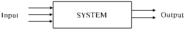
Figure 3. Black box representation of a system showing nonrelated (a) and interrelated (b) subsystems
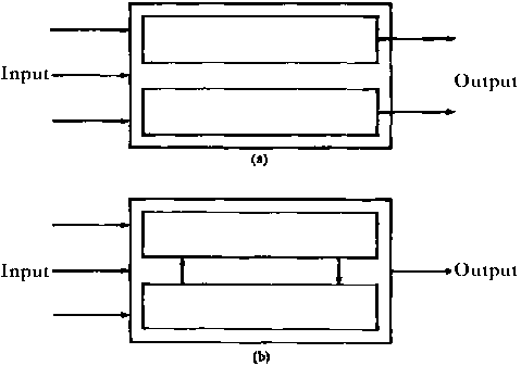
Figure 4. Matrix showing sectoral interfaces
|
INFORMATION PROVIDED BY |
INFORMATION REQUIRED BY | |||||
|
|
HYDROLOGY |
LIMNOLOGY |
PLANT ECOLOGY |
SANITARY ENGINEERING |
EPIDEMIOLOGY |
ECONOMICS |
|
HYDROLOGY |
|
Data on average, peak, and minimal flow; water quality in terms of suspended solids, bed load, and salinity. |
Characterization of hydrologic cycle, runoff data, giving peak, minimum and average seasonal flow; sedimentation/erosion processes. |
Data on average, peak, and minimum flow; water quality (current and potential). |
Data on average, peak, and minimum flow; changes in water regime that will result with project implementation. |
Estimation of probable sediment desposits in navigation areas with projects: reservoir life, water availability for irrigation, industrial, municipal use, and recreation. |
|
LIMNOLOGY |
Minimum and maximum temporal demands for water resource to sustain aquatic flora and fauna. |
|
Community succession in wetland areas. |
Characterization of water quality needs for aquatic biota. |
Identification of potential disease vectors and characterization of life histories; distribution in aquatic habitats. |
Identification of aquatic species; rearing areas of species having economic importance; estimate of loss of aquatic species as a result of projects. |
|
PLANT ECOLOGY |
Evapotranspiration rates of actual and potential land and water plants; erosion control characteristics of plant communities. |
Plant biomass carried to stream; biomass that would be covered in reservoir area (by major species). |
|
|
Identification of potential disease vector habitats. |
Indication of carrying capacities of land resource for domestic and wild animals. |
|
SANITARY ENGINEERING |
Actual and potential water contaminants; demand for water resource to dilute contaminants. |
Water quality data currently and with implementation of project. |
|
|
|
Potential effects of water quality changes as a result of projects, treatment alternatives; mitigation measures. |
|
EPIDEMIOLOGY |
Characteristics of aquatic habitats required by disease vectors. |
Data on biological control of disease vectors. |
|
Actual and potential disease foci with estimates of incidence. |
|
Identification of methods or programs for disease prevention. |
|
ECONOMICS |
Economic evaluation of impacts from proposed actions; calculation of preservation value of area's water resources. |
Economic evaluation of impacts from proposed actions; calculation of preservation value associated with aquatic system resources. |
Economic evaluation of loss or use of native plant species; calculation of preservation values associated with terrestrial vegetation. |
|
|
|
Figure 5. Flow diagram showing the effects of a dam on the process of erosion and fish production

![]()
![]()
![]()
![]()