

PREFACE
ACKNOWLEDGEMENTS
1.0 THE CONTEXT OF HURRICANE LOSS ESTIMATION IN THE CARIBBEAN
2.0 RELEVANCE, VALUE, AND IMPORTANCE OF LOSS ESTIMATION TOOLS
3.0 DESCRIPTION AND EXAMPLES OF USE OF THE TOOLS NEEDED FOR
BUILDING LOSS ESTIMATION
4.0 SUMMARY AND CONCLUSIONS
5.0 REFERENCES
TABLES AND FIGURES
This document was prepared as an activity of the Caribbean Disaster Mitigation Project (CDMP), a five-year regional effort being executed by the General Secretariat of the Organization of American States (OAS) with funding from the United States Agency for International Development (USAID). One of the objectives of the CDMP is to assist the insurance and reinsurance indsutries in the Caribbean to better cope with the effect of natural disasters on their business environment, since the techniques used thus far to estimate liabilities resulting from events such as hurricanes have beern seriously inadequate.
This report is intended to help alleviate some of this weakness. It is designed to educate senior-level Caribbean officials, in both government and industry, abou the importance of damage or loss estimation to the disaster-managemenrt process, and about how it is done.
Section 1 gives an overview of the subject, emphasizing the need. Section 2 presents the tools, techniques, and skills necessary for performing a loss estimation on buildings in a hurricane environment. In Section 3, these toolds are described in more detail, together with several examples of their use in developing answers to questions of interest to senor officals of government and the insurance industry. Brief discussions on the uncertainty associated with using such methodologies and on the rational selection of software products for loss estimation are also presented.
The field is evolving. The model and examples shown in this report give one approach, and a good one it is. General principles will always hold, but future research and experience are likely to generate alternatives and improvements to the model shown here. The eader needs to understnad the dynamic nature of the subject material and to be ready for future changes as they appear.
The General Secretariat of the OAS hopes that htis report and exercise will be helpful to he Caribbean regional insurance industry, and welcomes any questions that may arise concerning its contents.
Kirk P. Rodgers
Director
Unit of Sustainable Development and Environment
I am grateful to Mr. Jan Vermeiren, Principal Specialist, Department of Regional Development and Environment, Organizational of American States, for providing me the opportunity to make a potential contribution to the understanding, management, and control of losses as a result of hurricanes in the Caribbean Region. I also acknowledge five individuals without whose contributions the quality of this work could not have been achieved. First, I thank Ms. Gladys Higgins for her contribution of typesetting, editing, and proofreading the document. Second, I thank Mr. Sang-Hyun Choi for his contribution in making all of the necessary computations and using computer graphics to generate the figures. Third, I thank my colleague, Dr. Dale C. Perry (Dockery Professor of Housing, College of Architecture, Texas A&M University) for his external review of the technical accuracy of the document. Fourth, I thank Ms. Cynthia Warren for her external review of the document with regards to the appropriateness of its grammar and syntax, and its readability from the viewpoint of a non-specialist. Finally, I thank Mr. Hartley Saunders, a former senior government official in the Caribbean, for his external review of the document from the perspective a senior government official and a senior insurance official.
A hurricane is a tropical storm with winds that have reached or exceeded a sustained speed of 74 miles per hour (using the U.S. one-minute average sampling time). Theoretically, hurricane winds may exceed speeds of 200 miles per hour. In the northern hemisphere, hurricane winds move in a counterclockwise spiral around a relatively calm and dry center known as the "eye". Assuming that the hurricane is moving in a northerly direction, the region of highest wind speeds is directly to the east of the eye. The wind speed decreases with distance from the eye. Hurricane force winds may extend over regions with diameters ranging from 90 to 180 miles. Torrential rainfall, high winds, storm surges, and strong wave action are associated with the hurricane as it approaches land. Overland, additional hazards of water borne debris and airborne missiles are also associated with hurricanes. A single hurricane, which can travel with translational speeds ranging from 0 to 75 miles per hour, can exist for several weeks over open water and can encompass a path from the eastern Caribbean to the eastern seaboard of Canada. The hurricane season extends from June 1 to November 30; August and September are usually the months with the most activity.
The value (in terms of human lives, property, and economic activity) exposed to the hurricane hazard in the Caribbean is enormous. On the basis of data presented in the 1995 World Fact Book (CIA, 1995), the following assessment of the value exposed to hurricanes in the Caribbean can be developed (See Table 1): (1) the total population of the region is approximately 41 million; (2) the combined gross domestic product (GDP) is approximately $122 billion; (3) three countries have a GDP per capita greater than $15 thousand, five countries have a GDP per capita between $10 thousand and $15 thousand, six countries have a GDP per capita between $5 thousand and $10 thousand, and eleven countries have a GDP per capita below $5 thousand annually; and (4) the estimated combined external debt is $30 billion.
The tremendous forces unleashed by hurricanes recognize no geopolitical, cultural, or economic boundaries. A single event can cause many casualties, destroy property, disrupt the economy, impair the infrastructure, and interrupt electronic and physical communication with the outside world. In 1995 alone, for example, from August 28 to September 11, Hurricane Luis, with maximum sustained winds of 140 miles per hour, caused $2.5 billion in damage and killed 15 people in the Caribbean. In addition, from September 12 to September 22, Hurricane Marilyn, with maximum sustained winds of 115 miles per hour, caused $1.5 billion in damage and killed eight people in the Caribbean (National Hurricane Center News Accounts, 1995).
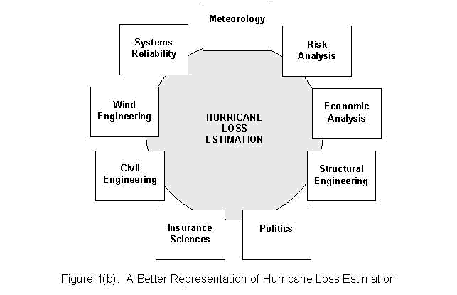
A hurricane loss estimate is a description or forecast of the devastation produced by future or hypothetical hurricanes. In the most general sense, the term "loss" can encompass such items as the number of fatalities and injuries; the direct repair costs/replacement cost; damage or functional loss to communication, transportation, and other lifeline or infrastructure systems; the cost of business interruptions; the number of those residents made homeless; etc. (FEMA, 1989). Loss estimation in natural and man-made hazards is an emerging multidisciplinary field. As shown in Figure 1a, loss estimation in hurricanes should not be considered as simply a subset of the field of Wind Engineering. Rather, Hurricane Loss Estimation should be viewed as is shown in Figure 1b which depicts the major traditional disciplines that support the field.
Government agencies and the insurance and reinsurance industry are two entities that are particularly interested in hurricane loss estimation studies. On the one hand, as far as hurricanes are concerned, government agencies, in one way or the other, are interested in managing or controlling the disastrous state of affairs that follows a hurricane strike. Government is (or should be?) interested in minimizing damage to the built environment, loss of life and economic and social disruption during and after a hurricane. In general, the overall management of a disaster resulting from a hurricane strike or any other hazard can be divided into four phases:
The estimation of losses to the built environment in the event of a hurricane is closely related to the phases of disaster management. In the mitigation phase, for example, three options are possible. The first option is to avert the hazard. Since in the foreseeable future mankind's capability to control such massive natural forces as hurricanes is limited, the aversion option is not feasible. The second option is to reduce the magnitude of the hazard on the structure of interest. This end can be achieved to a certain extent by site selection (e.g., not building on the coastline or taking advantage of protective topographical characteristics). The third option is to increase the resistance (i.e., increase the strength or equivalently (in other words) reduce the vulnerability) of the structure. Since we have some control over design practices and materials selection, this option will result in the most practical solution. In order to increase the resistance of existing and new structures in a cost-effective manner, at least three steps must be performed. First, methods of increasing the resistance of new construction via the implementation of improved codes, building practices, and building technology must be identified. Second, methods of increasing the resistances of existing construction via retro-fitting must be identified. Finally, methods of selecting those construction techniques and codes that are most cost-effective must be identified. In order to perform any analysis of cost-effectiveness, methods of estimating the cost of damage to structures must be identified. Similar arguments can be developed for establishing the importance of hurricane loss estimation for the other phases of disaster management.
On the other hand, the insurance and reinsurance industries are business entities with the objective of making a fair profit (a noble end in this writer's opinion). The profitability of such institutions depends upon, in the long term, the direction of the balance (i.e., positive or negative) between income from premiums and outflows from operations costs, repair/replacement costs and living expenses/business interruption costs. An insurance company wants to know how much it will have to pay out to clients with a specified exposure in a given region if a hurricane of a particular magnitude should impact that region and how the magnitude of that disbursement would impact the profitability (or future existence) of the company. Consequently, the insurance industry is interested in the risks posed by individual buildings at specific sites (especially those more expensive structures), classes of buildings, and portfolios of buildings.
At the present time, most hurricane loss estimation methodologies follow the traditional Probable Maximum Loss (PML) approach. By definition, a PML is a number which expresses the expected monetary loss for a structure, a class of structures, or a portfolio of structures, as a percentage of the total insured value when the structure, class of structures, or portfolio of structures is subjected to a predefined hazard magnitude. A PML calculation may include the following steps: (1) a definition of the territory of interest, (2) the division of that territory into appropriate zones, (3) the definition of "maximum credible" events (in our case perhaps a hurricane of Category III or Category IV) for which actuarial loss data are available, (4) the application of the desired hazard to each zone, and (5) the estimation of the PML. For example, a PML of 10 percent might be assigned to a hypothetical single story, wooden, residential building located in St. Kitts and subjected to a Category II Saffir-Simpson Hurricane (96-110 miles per hour, one-minute sustained).
Although the PML methodology is logical and does apply to situations in which a large data base exists for a time that is long compared to the mean recurrence interval for the event under consideration (for example, fires and automobile accidents), the approach may have some fundamental limitations if it were applied to estimating hurricane losses, in general, or, specifically, hurricane losses in the Caribbean Region. Some of the major objections to the use of the PML methodology are elaborated upon below. First, although the PML methodology uses the term "probability", there is nothing probabilistic about the method. There is nothing random about the "maximum credible hazardous event" to which the structures are subjected or the resultant actuarial data that have been collected. Second, in the existing PML approach, actuarial data collected in, for example, Zone A of Region X is used as a basis for estimating the losses in Zone C of Region Y. In other words, PML calculations ignore not only the environmental differences between the site at which the loss data were collected and the site at which the PML estimate is to be made, but also, the methodology ignores any differences in construction practices (which can vary significantly) between the two zones. Some of these differences may result from, for example, relative improvements in building practices and the adoption of stronger codes. Third, PML calculations ignore the random nature of events such as hurricanes. If one assumes that a hurricane of a certain magnitude is to strike a given location, then somehow the probability of occurrence of that event should also be factored into the analysis. Closely related to this point is the question of whether or not the historical record of existing data bases for the current actuarial data is sufficiently long to be statistically significant. Although there are more limitations associated with the traditional PML approaches (insofar as they are applicable to hurricanes), only one more will be mentioned here. Existing PML methods ignore the time value of money. The time value of money should be an integral part of any rational analysis that deals with the benefit/cost analysis of a mitigation/prevention option or study to set equitable premiums that reflect hazard risks and the reduction in damage that may result from such mitigative options.
In the case of the Caribbean Region, it will be difficult or impossible to perform a PML type calculation for several reasons. Three of these reasons are discussed below. First, no proper actuarial database currently exists for the Caribbean building stock. If it existed, such a database should include a logical classification of buildings, a notation of the hurricane magnitude to which the buildings were subjected, and the PML for each building class. Second, if such a database were available (if only for a few islands), the large variation in building practices and traditions in the Caribbean would greatly limit the application of the existing databases to other regions. Third, since the bulk of the building stock in the Caribbean has been built within the last thirty to forty years and most of these building have not experienced a hurricane, the concept of an actuarial database has no meaning in this context.
Given the short-comings of the PML approach in the hurricane environment and the existing condition of the built environment in the Caribbean region, government officials (who need to manage the hurricane hazard) and insurance officials (who need to manage insurance risks) both need a reliable and accurate method that is capable of estimating the losses sustained in future hurricanes by (1) a single structure (e.g., a specific hotel complex), (2) a class of structures (e.g., single-story, residential, wood-framed structures), or (3) an entire portfolio of buildings. To be realistic, the loss calculation methodology to be used in the future should include at a minimum the following items: the hurricane magnitude (i.e., its designation on the Saffir-Simpson Scale), its probabilistic nature (i.e., the annual probability of occurrence developed on the basis of historical records and computer simulation), the physical characteristics of the site (i.e., the terrain roughness and protection or hazard offered by e.g., trees and other buildings), the strength of the buildings (e.g., the resisting capacity of the roof system, the exterior cladding, or the foundation) and the vulnerability of the contents of the structure (i.e., given damage to the structure, one needs to know when damage to contents will begin). In order to accommodate the large variation in building practices in the Caribbean Region, future methodologies should incorporate as much knowledge (e.g., governing code, time of construction, materials, etc.) as possible about the specific building. The methodology should also be capable of providing information in a format that is (1) consistent with the four phases of the disaster management process, and (2) useful to the insurance industry for evaluation of risks and setting premiums.
The goal of this report is to inform senior Caribbean government officials and senior insurance officials of some of the key issues involved in the emerging discipline of hurricane loss (or damage) estimation. To meet this goal, this report attempts to accomplish the following three objectives:
This work is limited to a discussion of the estimation of building damage as a result of hurricanes in the Caribbean. Building damage is defined here as the ratio of repair cost/replacement costs. The repair cost includes the cost to repair any portion of the building as well as the cost to repair or replace damaged contents of the building. The types of buildings upon which this study will focus include:
The remaining sections of this report are organized in the following manner. Section 2 presents a development of what tools, techniques, and skills are needed in order to perform a loss estimation of buildings in a hurricane environment. Section 3 describes these tools in more detail and presents several examples of the use of the tools in developing answers to question of interest to senior government officials and insurance officials. Finally, the key concepts discussed in Sections 1 to 3 are summarized in Section 4.
In managing the hurricane hazard, government and insurance officials may be interested in obtaining answers to such questions as:
Two schemes for obtaining answers to the questions posed in Section 2.1 are outlined in Figure 2 and Figure 3. For the sake of clarity, only the wind component of the hazard is considered in the figures. The same model also applies for other components (e.g., surge and wave action) of the hurricane hazard. Figure 2 outlines how answers to Question (1) and Question (6) may be obtained. The structure that is referred to in Figure 2 may be a single building, a class of buildings, or all of the buildings in a given zone. In the latter case, the buildings in a zone are subdivided into individual classes of buildings appropriate to the zone under study, the calculations performed for each class of buildings separately, and the results for the zone obtained by summing the results for the individual classes. Note that it is often convenient to break the building down into three subdivisions: (1) the main load-resisting system (i.e., foundation, foundation-frame connection, main framing system, lateral bracing system, and roof framing) and the envelope which keeps out the weather (i.e., the roofing membrane, roof decking, exterior wall, and doors and windows); (2) the nonstructural elements (i.e., interior partitions and ceilings); and (3) the actual contents of the building.
Note also in the figure that the estimated loss is the sum of the cost of structural damage, nonstructural damage, and content damage. To compute the cost of structural damage one has to know the magnitude of the hurricane hazard (i.e., the demand on the structure) that the building experiences at the site in question and the vulnerability (or strength) of the structure. One must also have some means of combining the demand and resistance to come up with some estimate of the loss. In order to estimate the magnitude of the hurricane at the site, one needs to know some nominal value of the hurricane magnitude (e.g., wind speed over water at 10 meter height above sea level) and the so-called exposure of the building (i.e., the nature of the type of surroundings (e.g., density of housing, distance inland, and siting). To take into consideration the impact of these factors on the modification of the hazard magnitude at a site, one also needs some kind of algorithm to appropriately modify (increase or decrease) the hazard magnitude.
As shown in Figure 2, similar reasoning is applied to the estimation of losses for the non-structural elements and losses for the contents. In the latter cases, however, the direct hazard to the contents and the nonstructural elements becomes the damage to the structure.
Finally, in order to obtain some estimate of the annual expected losses, data on the annual probability of occurrence of a hurricane are needed along with a risk analysis algorithm. In using the scheme in Figure 2, damage can be estimated for hurricanes of all categories and the results summed to give the annual risk for the site.
The other type of loss estimation is depicted in Figure 3. Here the objective is to determine the cost-effectiveness for some proposed technology versus a current technology. Examples here may include the use of a proposed new code versus the existing code, the impact of window protection on hurricane losses, or the use of a proposed new roofing technology versus shingles. Both the insurance industry and government agencies should be interested in such sensitivity studies.
To select the most cost-effective choice between two alternatives A and B, one needs to know two key pieces of information: (1) an estimate of the additional cost it takes to implement the proposed option and (2) an estimate of the reduction in loss that results from the use of the option. In addition to these two pieces of information, one needs some economic cost-effectiveness criterion (e.g., select the option that yields a positive net present value). The supporting modules or algorithms for computing losses to the structure are identical to the ones discussed in Figure 2. The difference here, however, is the specialization of the computations to the selected options along with other pieces of information such as the estimated life of the structure and the time value of money.
The major technical areas involved in hurricane loss estimation are meteorology, wind engineering, structural reliability, vulnerability analysis, engineering economy, computer programming, probability and statistics, and the actuarial sciences. From the latter section, the following data, skills, algorithms, and other resources needed to support the loss estimation process can be identified. First, information is needed to define the hurricane hazard. At a minimum, this list might include a designation of the hurricane by a range of wind speeds; the historical trajectories of comparable hurricanes for a given location; the wind profile of comparable hurricanes; and statistical information on the annual probability of occurrence of hurricanes of a given magnitude. More sophisticated meteorological models may include mathematical models of hurricanes which relate such key parameters as radius of maximum wind, wind speed versus pressure distribution, and the size of the hurricane to the pressures in the eye and the ambient barometric pressure. Second, in order to estimate losses to the structure, as defined above, one must not only be able to account for the location of the structure, the characteristics of the surrounding region (i.e., the exposure), and the resistance of the structure, but also have in place computer algorithms to estimate damage as a function of the magnitude of the modified hazard and the resistance of the structure. The resistances or strength of the structure should be based on engineering calculations whenever possible and should take the characteristics of the local construction practices into consideration. Analogous information and algorithms are also needed to estimate the damage to the nonstructural elements and damage to the contents.
The main sources of information needed to provide the basic input into the loss calculations include meteorological records, the results of post-hurricane disaster studies in the Caribbean, Caribbean building codes, records of field inspections by engineers of Caribbean buildings during construction, field inspections by engineers of existing buildings, samples of insurance companies payout records for the Caribbean Region, and expert opinion provided by Caribbean design/construction professionals regarding the integrity of various building components. A matrix in which the sources of information are related to the required input variables is provided in Table 2.
The elements of a hurricane loss calculation such as those depicted in Figure 2 and Figure 3 comprise an important component of hurricane disaster management and insurance risks management. Many advantages associated with the use of such tools can be listed but only five will be mentioned here. First, the tools are helpful in the planning stages of the hurricane management process. For example, in the mitigation phase of the process, the tools may provide government officials with the capability to identify rationally potential, cost-effective, mitigative technologies. As another example, the disaster and post-disaster phases can be planned more effectively if officials were aware beforehand which buildings would be adversely affected by the hurricane. Second, the tools could provide the basis for an improved method of evaluating the hurricane management process. For example, the improved information provided by the loss estimation process could lead to more rational decision making. Third, the tools provide a rational means of evaluating insurance risks. For example, given any hurricane scenario, loss information could be provided at the building level, at the port folio level, or even at the island or multi-island level. Fourth, using, the same kind of information provided by the tools, insurance companies can make more informed decisions regarding the underwriting of single potential risks, underwriting a particular class of structures, or even investing in a given zone. Finally, by utilizing estimates of inflow from future premiums and outflows from hurricane losses and with the aid of economic analysis techniques such as cost/benefit analysis, insurance and government officials have a rational basis for setting equitable premiums.
The objective of the former two sections was to make senior government and insurance officials more aware of the context, relevance, value, and importance and to a certain extent, the state-of-the art of damage estimation tools. In this section the goal is to achieve the remaining two objectives; namely (1) to provide the officials with a somewhat more indepth description of the tools and the concepts of hurricane loss estimation and (2) to provide them with some sense of how the tools are utilized, by way of examples. The avoidance of equations in this section is intentional. Graphs and charts will be used as often as necessary to explain calculations. At this point it is important to stress that the field of loss estimation in hurricanes is in its infancy and there may be more than one way of modelling hurricanes and predicting the resulting damageability of buildings. The tools presented below represent one internally consistent approach to the problem of hurricane loss prediction.
There are at least three ways to consider a hurricane in a loss estimation study. First, one may consider a past hurricane with a known wind field distribution, subject a predetermined zone to this field, and then compute the resulting losses. In general the variation of wind intensity over the zone of interest will depend upon the size and meteorological characteristics of the hurricane and certain physical characteristics of the zone. The loss estimate, under these conditions, has been developed on the basis of a "scenario" hurricane.
A second approach is to use several scenario hurricanes as a basis for the loss estimate. While the results of such combinations are easy to understand and explain, one is never quite sure that a single hurricane with a highly unlikely chance of occurrence has been omitted from the analysis. This shortcoming forms the weakness of using scenario events.
A third and more comprehensive approach is to calculate the losses at a given location by considering many hurricanes and assigning a probability of occurrence to each hurricane. This approach will lead to the annual frequency with which different losses are expected to occur; or, alternatively, the annual expected loss at a given location for a defined value of exposed buildings.
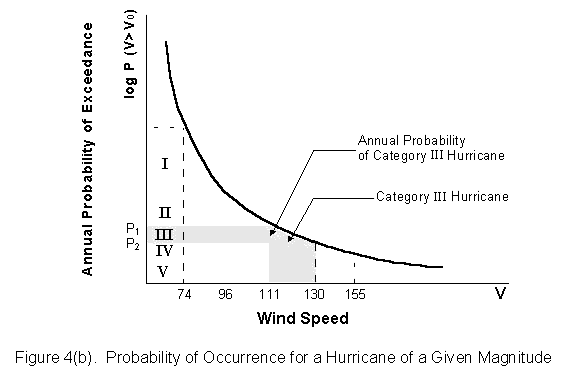
A typical extreme wind risk curve for a specific location is shown in Figure 4(a). The graph is interpreted as follows: at point A, which corresponds to a wind speed Vo and a probability Po, the probability that a given location will experience a wind speed greater than Vo is Po. Thus, given the general shape of the curve which tends to flatten out as the wind speed increases, the higher the wind speed Vo, the lower is the annual probability of occurrence of a wind event that exceeds the value Vo. If the wind speed axis is subdivided into sections that correspond to the Saffir-Simpson scale, the probability of a hurricane of a given size can be obtained directly as the difference in the probability of exceedance corresponding to the limits of the hurricane range (See Figure 4(b)). Thus, once the annual probability of exceedance curve for a particular site is available, probabilities of hurricanes can be assigned. Points on the probability of exceedance curve for several countries in the Caribbean are presented in Table 3.
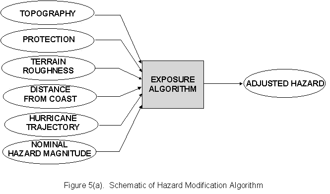
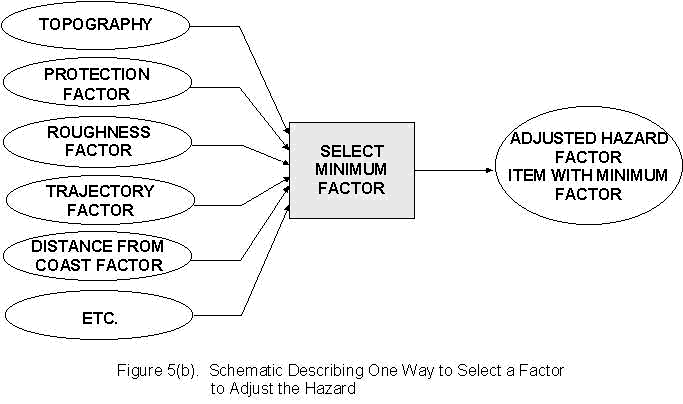
Hurricane wind speeds that are reported by the National Hurricane Center are generally not at the building level. The wind speeds reported are usually several thousand feet above sea level and are usually over water. The wind speeds present at the surface depend upon such factors as the topography of the region, the terrain roughness, protection offered by other buildings, etc. As shown in Figure 5(a), these effects must be taken into account in order to assign the correct wind speed at a given site. One way to achieve this end is shown in Figure 5(b). In Table 4, how this approach was applied to modify the wind speeds of a hurricane crossing the Gulf Coast in a northerly direction is demonstrated.
There are two steps in the hurricane loss estimation procedure: (1) developing an inventory of the buildings to be evaluated in the study, and (2) establishing for each category of buildings in that inventory the relationship between hurricane magnitude (in terms of wind speed) and the resulting losses (in terms of damage ratios). A key step in defining a building inventory is the establishment of a building classification system. To be site specific and useful, such a classification system should be guided by considerations such as: (1) the buildings that end up in a single category should be described by the same set of features, (2) the number of categories selected should be manageable, (3) the classification criteria should evolve from the engineering and cultural history of the specific zone being analyzed, and (4) the classification system should be internally consistent.
The form of a typical Building Damage Vs Wind Speed curve (also called a damageability function) is shown in Figure 6(c). Such curves are characterized by the typical s-shape (or sigmoidal shape). There are at least two ways of generating such a curve: (1) by analyzing actuarial data collected in past hurricanes, or (2) by developing mathematical models of building damage behavior and calibrating the models for a specific building class, set of construction practices, and region. Since the second approach provides more insight into the damage process in buildings in a hurricane environment, that approach will form the basis of the subsequent discussion.
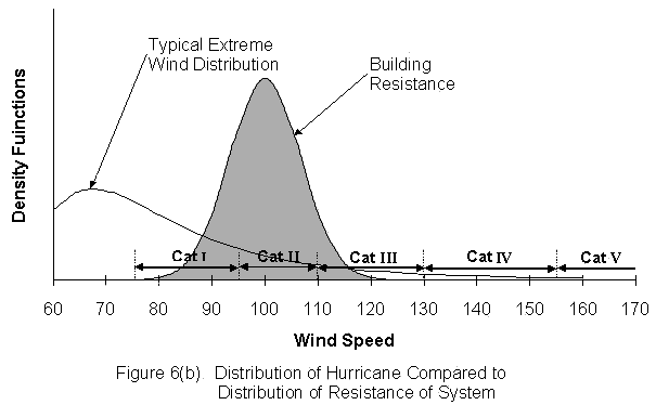
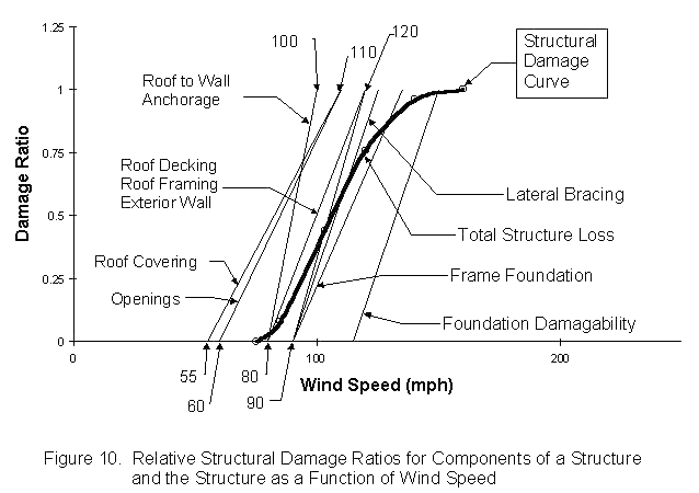
The generic model for estimating building damage is depicted in Figure 6(a). At the most basic level, the loss estimation algorithm accepts two inputs: the resistance (i.e., the strength) of the building and hazard (i.e., the magnitude of the hurricane). The hurricane hazard at a given location may range from magnitudes corresponding to Category I to Category V. Because of the uncertainties associated with the quality of materials and construction practices, one can, at best, only specify the strength of a class of building to within a range of wind speeds. In Figure 6(b), all hurricanes at a site and the resistance of a class of buildings are represented as density functions. The loss estimation algorithm computes the probability that the magnitude of the hurricane is greater than the resistance of the building. That number is then related to the damage to the building. Using that concept as a basis for assigning loss, it can seen in Figures 6(b) and 6(c) that for wind speeds approximately below 80 miles per hour, the building resistance is always greater than the hurricane magnitude and, therefore, the probability that system resistance is less than hurricane magnitude is zero. For wind speeds above 120 miles per hour, the reverse is true, and the probability is always one. For hurricane wind speeds between 80 and 120 miles per hour (i.e., the region of interaction), probability (or, the mean damage ratio) increases steadily from zero to one.
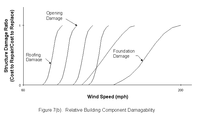
If a loss estimation algorithm is to account for building practices at arbitrary locations and, at the same time, reflect the impact on the strength of the entire building of such items as the quality of construction of the various building components, the building code used, the component's age, and the component's existing condition, then the one-dimensional resistance used to describe a building in the last section is much too crude a description of a building. What loss estimators need is a way of relating the quality of a building system to the quality of its components. In previous research (Stubbs et al., 1995), it has been proposed that the critical components of a building in resisting damage in a wind environment are the following: the roof covering, the roof decking, the roof-framing system, the roof frame to wall connection, the lateral-bracing system, the exterior wall, the openings, the frame-foundation connection, and the foundation itself. Damage to any one of these components leads to damage to the structure, damage to the nonstructural element, and damage to the contents.
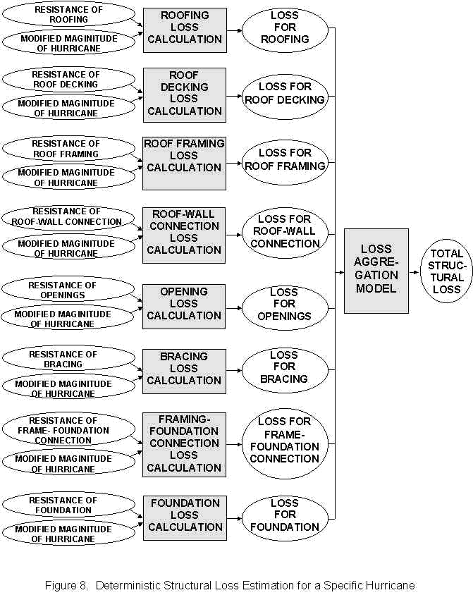
In order to improve upon the one-dimensional model, the basic loss estimation scheme described in Figure 6(a) is applied to each of the building components identified above. Schematic distributions representing the strength of each component are shown in Figure 7(a). For buildings in a given region, these distributions must be developed on the basis of a combination of tests, historical observation, engineering calculations, and expert opinion. Any given resistance distribution may be shifted up or down to reflect such items as quality of construction and materials, age, and the existing condition of the component. The application of the loss algorithm to each of the components will yield the component losses (damageabilities) shown in Figure 7(b). The entire sequence of computations is depicted in Figure 8. To estimate the damage (loss) to the building, the component losses are aggregated using a so-called "Loss Aggregation Model".
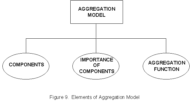
A generic Loss Aggregation Model is shown in Figure 9. The elements of the model include (1) a specification of all components (2) a specification of their relative importance (e.g., in terms of the cost and consequences of failure) of each component, and (3) an aggregation function that reflects the observed behavior of the given type of building system (e.g., account for the failure sequence differences in wooden structures versus masonry structures).
To demonstrate how the structural damage may be estimated, the following hypothetical example is provided. A set of single-story wood-framed structures with the following component construction is located on the coast of some island in an open area: Roofing-composition shingles, Roof Decking-plywood sheeting, Roof Framing-hip and rafters, Roof Framing to Wall Connection-toe nail, Lateral Bracing - 1"x4" let-ins, Exterior Wall-wooden planks, Openings-casement windows and wooden doors, Frame to Foundation Connection-"J" bolts or toe-nail, and Foundation-nonengineered slab on grade. After a site investigation and further analysis, the following range of resistances listed in Table 5 were generated. Since scarce data were available, the engineer had confidence in the range of component resistances but could say nothing definite about the nature of the distribution. He therefore assumed that it was uniform (i.e., rectangular). The problem here is to compute the loss curve for structural damage.
As indicated in Figure 8, the resistances in Table 5 and the hurricane magnitude are used to estimate the component losses. The resulting component damage ratios (See Figure 10) are shown as straight lines (because a uniform density was used). The resulting damage to the structure, using an aggregation function that dictates the structure will collapse when as little as two or three components collapse, was used. Note that the first reading for the total structure loss curve is not zero but some small number. Note, also, that with this methodology, the impact of strengthening or weakening any of the building components could be easily investigated.
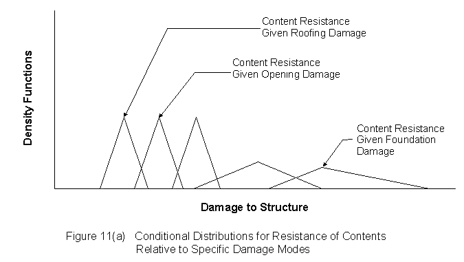
Content damage depends upon at least three items: (1) the failure probability of a component, (2) the exposure of the contents to that damage mode, and (3) the vulnerability of the contents given damage in that mode. The failure probability of the component is obtained from the structural damage calculations. The exposure of the contents for a given mode depends upon the spatial location of the contents relative to the location of the component in question. The resistance of contents relative to a given component can be expressed as a conditional density function. A schematic set of density functions for content damage for the various damage modes is shown in Figure 11(a). Assigning numbers to these distributions is an area of current research; therefore, one has to rely on expert judgment and very scarce historical records. However, one advantage of this approach is that a rational framework for the collection and analysis of content damage now exists.
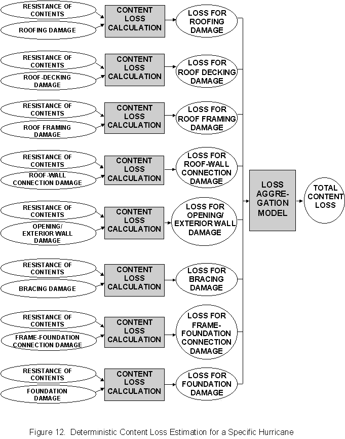
Given the resistance curves in Figure 11(a) and damage to the structure, the content damage for each building component can be estimated as shown in Figure 12. The content losses computed in the intermediate step of Figure 12 are shown in Figure 11(b). Knowing the relationship between component damage and wind speed from the structural damage calculations, the curves in Figure 11(b) can also express content damage in terms of wind speed. Next the content damage ratios are aggregated using a model such as the one discussed in Figure 9. Because the system that is formed by the structure and the contents is different from the system formed by the components to make the structure, the aggregation function for content losses may be quite different from that for the structure.
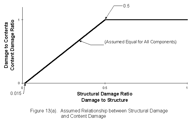
Presented below is a simple example to illustrate the computation of content damage. Assume that the same structure studied in the last section has contents whose resistance is between structural damage ratios 1.5 percent and 50 percent. Assuming, again, a uniform (rectangular) distribution, the damage to the components as a function of damage to the structure is shown in Figure 13(a). After aggregating the losses, total damage to contents as a function of wind speed is shown in Figure 13(b). Note, again, that even though the component damageability curves are linear, the total content loss curves are sigmoidal.
To compute annual losses for hurricanes, one needs only to combine the structural damage, the content damage, and the information on the annual probability of exceedance for a single hurricane or the exceedances for multiple hurricanes. Structural damage and content damage are estimated utilizing the procedures depicted in Figure 8 and Figure 12, respectively. Annual probability of exceedance is obtained from data such as those presented in Table 3. The scheme for estimating the annual expected loss for a single hurricane is given in Figure 14(a) and the scheme for estimating losses for all hurricanes is given in Figure 14(b).
A complete set of loss results for 1-2 story residential masonry buildings in a single county along the Gulf Coast is provided in Table 6 and Table 7. In Table 6 the structures are located on a barrier island and no adjustment is made for terrain, protection from foliage and/or other structures or wind speed attenuation as the hurricane moves inland. The mean structural damage ranges from 2.8 to 59.5 percent, respectively, for a Category I to Category V Hurricane. For the same range of hurricanes, the content damage increases from 0.2 to 58.1 percent. The single event (i.e., a single hurricane strike) in the third row of Table 6 represents the ratio of the sum of structural and content losses normalized by the replacement cost of the structure. In this calculation, the insured value of the contents was taken to be about sixty percent the replacement cost of the structure. As can be seen from Table 6, these damage ratios range from 2.9 to 94.4 percent, respectively, for a Category I and Category V hurricanes. The annual damage ratio in the last row of Table 6, a number that is obtained by combining the single event damage loss, corresponds to the annual expected loss for a Category I Hurricane depicted in Figure 14(a). Note that the annual expected loss is larger for the lower category storms and is comparatively negligible for a Category V hurricane.
A similar set of results for the same building class is presented in Table 7; however, this time the buildings are located a few miles inland from the coastline. First, note the wind speed reducing impact of protection, terrain effects, and hurricane attenuation on the actual wind speed that the building experiences. According to the model used in this estimate, the wind speeds of a Category I Hurricane have attenuated by 20.0 percent while those of a Category V Hurricane have also attenuated by 20.0 percent. On comparing the estimated losses in Table 6 with those in Table 7, one can clearly appreciate the drastic reduction in losses as the hurricane moves inland from the coast.
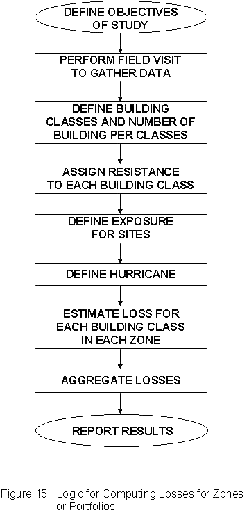
The final type of loss estimation to be considered here is the estimation of losses for many different building types in a single zone or in an extended region consisting of many zones. The general sequence for performing such a study is depicted in Figure 15. As will be shown in the example below, the objectives of such studies may vary significantly, depending upon which entity (insurance or government) commissions the loss study. Ideally a loss estimation study should be based on relevant documented data and, if possible, observations resulting from actual field visits. On the basis of the analysis of the data, building classes for the study should reflect local building practices and the history of the region. The assignment of resistances to each building class, definition of the exposure for the various zones, modification of the hurricane hazard, and estimation of the structural damage ratio and the content damage ratio should proceed as discussed above. From a knowledge of the percentage of each building class in a zone, the content and structural damage for the zone, and the total value insured in that zone, the expected losses for structural damage and content damage can be estimated for the zone. In a similar manner, the losses for the individual zones may be aggregated to yield the losses for the region.
The following summary example provides an idea of the kind of information that a loss calculation can yield for a zone or a larger region consisting of several zones. Occasionally, devastating hurricanes like Gilbert in 1989 that impacted Jamaica and the Yucatan Peninsula or Andrew in 1992 that impacted the Bahamas, Florida, and Louisiana become candidates for scenario hurricanes. Given the devastation incurred by such events, government and insurance officials may want to know the impact of such storms on their jurisdiction or territory. Recently the writer was assigned the problem of estimating the impact of an "Andrew-like" storm striking certain key properties in the New Orleans area. More specifically the insurer wanted answers to such questions as:
In solving the problem, the logical sequence presented in Figure 15 was followed here. For the sake of brevity, only the final results, which are summarized in Table 8, will be discussed below.
Eight building classes were selected for this study. The categories were determine by the main four periods of construction in the area (Pre-1940, 1940-1960, 1960-1980, and Post-1980) and the number of building stories (i.e., single story or greater than one story). Note that only residential construction was considered in this exercise.
The protection from wind was considered to be a function of the density and height of the foliage, relative to the houses, and the density of the buildings. For example, tall and dense trees provided relatively "excellent" protection from wind; while, short and dispersed trees provided relatively "poor" wind protection.
Each of the nine zones in Table 8 was identified by a combination of the predominant building classes in the zone and the wind protection offered by the surrounding foliage and building density. For example, Zone 1 was characterized by the massive, multi-story, pre-1940 (ante bellum) construction and tall, dense, tree covering; while, Zones 7 and 8 were characterized by smaller single-story, 1960-1980, residential construction. From Table 8, the structural damage ratio ranged from less than 0.1 percent (in Zones 3,6, and 9) to 99 percent (in Zones 7 and 8). The content damage ratio followed the same trend as the structural damage ratio but was usually higher in magnitude. The damage ratio for the valuables (another type of content) followed the same trend as the content damage ratio. Note that magnitudes of the valuables damage ratio are somewhat less than the values reported for the content damage ratio. This result follows from the fact that residents would make an extra effort to protect valuables in the event of a hurricane. The total insured value for each zone is given in Column 8. The insured value varies from $114 million in Zone 1 to $4.8 million in Zone 9. The expected losses for each zone are listed in Column 12 and range from a high value of $20.107 million for Zone 7 to a low value of $0.155 million for Zone 9. Note that the numbers listed in Column 10 represent the fraction of the value insured in a given zone (e.g., $114 million in Zone 1) relative to the value insured for the entire region (i.e., $411.2 million).
Even though the results presented in Table 8 were prepared for insurance officials who are interested in making sound business judgments, the same type of information is relevant to government officials who are interested in managing the hurricane event. For the scenario under consideration here, the result that the major damage to buildings will occur in Zones 7 and 8 and that the damage in these zones will be very severe may lead government officials to adjust their hurricane management strategy for the two zones in several ways. First, as a pre-disaster mitigation strategy, government officials may consider ways and means by which the affected classes of construction may be strengthened. Second, as a pre-disaster preparedness strategy, on recognizing that the threat to property and life in Zones 7 and 8 is acute, government officials should ensure that evacuation plans and warning systems are in place and understood by the residents in these zones. Third, as a disaster response strategy, knowing in advance where the greatest damage will occur, government officials can (1) make better decisions regarding the location and characteristics of shelters, and (2) optimize the staging and deployment of resources needed directly after the event. Finally, as a post-disaster recovery strategy, government's officials may either ban specific types of construction in Zones 7 and 8, or out-rightly disallow construction in those zones.
From the insurance officials' perspective, the results presented in Table 8 may also provide information for making sound business judgments. Note that while only approximately 9 percent of the insured value reside in Zones 7 and 8 (See Column 10), those zones account for approximately 75 percent of the expected losses. Note that Zones 1 and 2 account for approximately 10 percent of the losses but 53 percent of the insured value. At this stage, the wise insurance official might be advised either to cancel all insurances in Zones 7 and 8 or to readjust the premium and deductibles in the zone to reflect the expected losses and the constraint that the company must make some kind of profit.
The tools described above are intended to produce loss estimates resulting from scenario hurricanes or to estimate losses at a given location on an annual basis. In the first case, a hurricane with a known wind speed field is imposed on a region and the appropriate losses computed. In the second case, the probabilities associated with the hurricane occurrences are integrated into the loss estimate. No matter which approach is utilized, the uncertainties (i.e., the lack of knowledge or ignorance) in the loss estimates should always be noted (e.g., a range of possible values may be given). Uncertainties in hurricane loss estimation stem from many sources. First, there is uncertainty in the values reported for the nominal hurricane magnitude. Second, there is uncertainty associated with modifying the wind speed to reflect conditions at the site. Third, there are uncertainties associated with the various loss estimation algorithms as well as the assignment of resistances to structures and their contents. Finally, there is even uncertainty in the process of inventorying and classifying the buildings. As more data become available, these uncertainties will shrink but they can never be fully eliminated.
Recently, several organizations have produced commercial software packages for hurricane loss estimation. Since these products have been developed outside of the Caribbean and target buildings located primarily along the Gulf and Atlantic Coasts of the United States, potential Caribbean users of such technologies need to evaluate such packages carefully before selecting any one product. Certainly, one can develop a formal evaluation methodology for such products. At a minimum, such a methodology should contain the following seven considerations: (1) the methodology should accommodate building classes to be found in the Caribbean Region, (2) the methodology should contain a complete description of the hurricane hazard in the Caribbean region, (3) how the hazard is modified to address a specific site should be clearly stated, (4) details of the resistance model for structures and their contents should be stated along with all assumptions used to generate the models, (5) allowances should be made to exploit sources of information such as local meteorological records, post-disaster studies in the Caribbean, local building codes, field inspections, local insurance records, and the expert opinions on local design and construction, (6) an indication of the uncertainty associated with the methodology should be presented, and (7) validation examples of the methodology should be provided.
The end product of a loss estimation study depends heavily upon the user requirements. Products may range from reports such as the one presented in Table 8 to studies of the probable damage sustained in a hurricane by critical facilities such as hospitals, police stations, harbours, and airports. The effort that goes into a loss estimation study could be divided into the development of the building class, the collection of the vulnerability data, the generation of the hazard data, the computation of the loss data, and the generation of the report. Involved in this total effort are meteorologists, actuaries, structural engineers, wind engineers, computer programmers, and damageability experts.
The availability, or non-availability, of a working software package to the government agency or insurance company and the appropriate vulnerability data are the major factors that will determine the time a government agency or an insurance company will need in order to implement a major loss estimation study. A government agency or an insurance company may find itself in one of four extreme cases:
Case I - No loss estimation software and no vulnerability data,
Case II - No loss estimation software but vulnerability data,
Case III - Loss estimation software but no vulnerability data, and
Case IV - Loss estimation software and vulnerability data.
In the writer's opinion: if Case IV controls, loss studies can be completed in weeks; if Case II or Case III controls, studies can be implemented and completed in one to three months; and if Case I controls, two to six months may be needed to implement studies.
The major factors that determine the cost of a loss estimation study are (1) the amount of information that is to be embedded into the vulnerability curves (e.g., level of classification, age of construction, quality of construction, special building characteristics, etc.), (2) the amount of hazard information for a particular site (i.e. topography, terrain roughness, protection, etc..), and (3) the cost of the loss estimation software. Depending upon the source of the software program, item 3 above may vary tremendously.
To provide the reader with a realistic estimate of what is involved in a loss estimation study, the approximate numbers for the study in Table 8 are listed below:
Field visit - 4 man days
Determination of building classification - 1 man day
Development of hazard data - 1 man day
Development of vulnerability data - 2 man days
Loss estimation - 2 man days
Report preparation - 2 man days
Thus a total of 13 man days were used to complete the study. Assuming a rate structure of $1000.00 per man day, the cost for the referenced study is $13,000. Note this number assumes that software was in place and the study was performed by professionals familiar with the methodologies. Since eight building classes were used in the study, a ball-park estimate of the cost of a loss estimation study is $13,000/8 = $1,685 per building class. Certainly, this number will move up or down depending upon local conditions.
The goal of this report was to inform senior Caribbean government officials and senior insurance officials of some of the key issues involved in the emerging discipline of hurricane loss (or damage) estimation for buildings. To meet this goal, this report attempted to accomplish the following three objectives:
- To make senior government and insurance officials aware of the relevance, value, and importance of loss estimation tools and techniques in the Caribbean region;
- To provide the officials with an overview at a conceptual level of the specific tools, techniques, and skills needed to perform a loss estimation study; and
- By way of examples, to provide the officials with a knowledge and appreciation of how the tools are used in loss estimation.
In Section 1 of the report, an overview of the context of hurricane loss estimation in the Caribbean was presented. The relevance of the need for hurricane loss estimation to senior government officials and insurance officials was emphasized. Section 2 presented a development of what tools, techniques, and skills were needed in order to perform a loss estimation on buildings in a hurricane environment. Section 3 described these tools in more detail and presented several examples of the use of the tools in developing answers to the questions of interest to senior government officials and insurance officials. Brief discussions on the uncertainty associated with using such methodologies, the selection of potential hurricane loss estimation software products, and the effort, time, and cost needed to implement a loss estimation study were also presented in that section.
In conclusion, the application of the tools of hurricane loss estimation can simultaneously impact such important activities as the efficiency of hurricane disaster management process and the profitability of insurance risk management. More specifically, the application of these tools can lead to the following benefits:
Caribbean Community Secretariat, Caribbean Uniform Building Code, Part 2, Structural Design Requirements, Georgetown, Guyana, 1989.
Central Intelligence Agency, The World Factbook, NTIS, Washington, D.C., 1995.
Cleary, Bruce B., "The Evolution and Structure of Natural Hazards Policies", Public Administration Review, American Society of Public Administration, 1985, pp. 20-21.
Federal Emergency Management Agency, Estimating Losses from Future Earthquakes, Panel Report and Technical Background, Washington, D.C.: Committee on Earthquake Engineering, Division of Natural Hazard Mitigation, FEMA-177, June 1989.
Hurricane Center News Accounts, National Hurricane Center, Coral Gables, FL., 1995.
Stubbs, N., Perry, D., and Lombard, P., Cost-Effectiveness of the New Building Code for Windstorm Resistant Construction Along the Texas Coast, Final Report, Submitted to the Texas Department of Insurance, Austin, Texas, March 1995.
| Country | Population | GDP | GDP/CAP | Debt |
| Anguilla | 7,099 | 49,000,000 | 7,000 | N/A |
| Antigua & Barbuda | 65,176 | 400,000,000 | 6,000 | 250,000,00 |
| Aruba | 65,974 | 1,100,000,000 | 17,000 | 81,000,000 |
| The Bahamas | 256,616 | 4,400,000,000 | 15,000 | 455,000,000 |
| Barbados | 256,395 | 2,4000,000,000 | 9,200 | 652,000,000 |
| Belize | 214,061 | 575,000,000 | 2,750 | 158,000,000 |
| British Virgin's Islands | 13,027 | 133,000,000 | 10,600 | 4,500,000 |
| Cayman Islands | 33,192 | 700,000,000 | 23,000 | 15,000,000 |
| Cuba | 10,937,635 | 14,000,000,000 | 1,260 | 10,000,000,000 |
| Dominica | 82,608 | 200,000,000 | 2,260 | 92,800,000 |
| Dominican Republic | 7,511,263 | 24,000,000,000 | 3,070 | 4,300,000,000 |
| Guyana | 723,774 | 1,400,000,000 | 1,950 | 2,200,000,000 |
| Haiti | 6,539,983 | 5,600,000,000 | 870 | 871,000,000 |
| Honduras | 5,459,743 | 9,700,000,000 | 1,820 | 4,000,000,000 |
| Jamaica | 2,574,291 | 7,800,000,000 | 3,050 | 3,600,000,000 |
| Martinique | 394,787 | 3,900,000,000 | 10,000 | N/A |
| Montserrat | 12,730 | 55,600,000 | 4,380 | 2,050,000 |
| Netherlands Antilles | 203,505 | 1,850,000,000 | 10,000 | 672,000,000 |
| Puerto Rico | 3,812,569 | 26,800,000,000 | 7,050 | N/A |
| Saint Kitts and Nevis | 40,992 | 210,000,000 | 5,300 | 43,300,000 |
| Saint Lucia | 150,050 | 610,000,000 | 4,200 | 96,400,000 |
| Saint Vincent and Grenadines | 117,344 | 235,000,000 | 2,000 | 74,900,00 |
| Trinidad and Tobago | 1,271,159 | 15,000,000,000 | 11,280 | 2,000,000,000 |
| Turks and Caicos Islands | 13,941 | 80,800,000 | 6,000 | N/A |
| U.S. Virgin Island | 97,229 | 1,200,000,000 | 11,000 | N/A |
| TOTAL | 40,855,143 | 122,398,400,000 | 30,367,950,000 |
Source: Central Intelligence Agency, The World Factbook, NTIS, Washington D.C., 1995
| Needed Input | Metero. Records | Post Dis. Studies | Codes | Insp. Dur. Constr. | Insp. of Ex. Bldg. | Insurance Payout | Local Design Professionals |
| Hurricane Risk | * | * | |||||
| Hurricane Magnitude | * | * | * | ||||
| Hurricane Trajectory | * | * | * | * | |||
| Hurricane Profile | * | * | * | * | |||
| Building Exposure | * | * | * | * | * | ||
| Building Vulnerability | * | * | * | * | * | * | |
| Nonstructural Exposure | * | * | * | * | * | * | |
| Nonstructural Vulnerability | * | * | * | * | * | ||
| Contents Exposure | * | * | * | * | * | ||
| Contents Vulnerability | * | * | * | * |
| Wind Speeds (Vo) [mph sustained] | ||||
| Annual Probability of Exceedance | ||||
| Location | 0.02 | 0.01 | 0.005 | 0.002 |
| Guyana | 57 | 66 | 74 | 84 |
| Trinidad (N) | 61 | 71 | 79 | 90 |
| Trinidad (S) | 75 | 87 | 97 | 109 |
| Tobago | 79 | 90 | 100 | 112 |
| Grenada | 89 | 100 | 110 | 122 |
| Barbados | 95 | 106 | 116 | 128 |
| St. Vincent | 97 | 108 | 117 | 159 |
| St. Lucia | 98 | 109 | 119 | 130 |
| Dominica | 104 | 115 | 125 | 137 |
| Montserrat | 104 | 116 | 126 | 139 |
| Antigua | 103 | 115 | 125 | 137 |
| St. Kitts | 104 | 116 | 126 | 139 |
| Jamaica | 101 | 112 | 121 | 133 |
| Puerto-Rico | 104 | 116 | 125 | 137 |
| US. Virgin | 101 | 112 | 121 | 133 |
| Belize (N) | 101 | 112 | 122 | 134 |
| Belize (S) | 85 | 93 | 102 | 112 |
*Developed from data presented in Table A201.1, Caribbean Uniform Building Code (1989)
| Typical Adjustment Factors | ||||
| Factor | Barrier Island | Coastal County | 30 Miles Inland | 45 Miles Inland |
| Attenuation (distance from Coast) | 1.00 | 0.97 | 0.92 | 0.82 |
| Hurricane Profile | 1.00 | 0.99 | 1.00 | 0.95 |
| Terrain Exposure | 1.20 | 0.89 | 0.89 | 1.00 |
| Shelthering Effect | 1.00 | 0.80 | 0.80 | 0.80 |
| Mininimum Factor Value | 1.00 | 0.80 | 0.80 | 0.80 |
| Resistance Thresholds* (mph, One-Minute Sustained) | ||
| Building Component | Low | High |
| Roof Covering | 55 | 110 |
| Roof Decking | 80 | 120 |
| Roof Framing | 80 | 120 |
| Roof-Wall Anchorage Damage Via Suction | 90 | 120 |
| Roof-Wall Anchorage Damage Via Suct. & Int Pressure | 80 | 100 |
| Lateral Bracing System | 90 | 125 |
| Openings | 60 | 110 |
| Cladding Damage | 80 | 120 |
| Frame-Foundation Connection Damage | 90 | 135 |
| Foundation Damage | 115 | 150 |
| Damage Magnitude (Percent) | |||||
| Saffir-Simpson
Hurricane Category (Mean Speed mph one-minute sustained) |
|||||
| Damage Type | I (85) |
II (103) |
III (120) |
IV (140) |
V (160) |
| Structural Damage Ratio: | 2.8 | 10.1 | 24.0 | 41.8 | 59.5 |
| Content Damage Ratio: | 0.2 | 4.1 | 14.6 | 35.5 | 58.1 |
| Single Event Damage Loss: | 2.9 | 12.5 | 32.8 | 63.1 | 94.4 |
| Annual Event Damage Loss: | 0.2 | 0.2 | 0.2 | 0.1 | * |
Annual Mean Damage Ratio for all Hurricane Categories: 0.7 percent
*Negligible
| Damage Magnitude (Percent) | |||||
| Saffir-Simpson
Hurricane Category (Mean Speed, mph) |
|||||
| Damage Type | I (68) |
II (82) |
III (96) |
IV (112) |
V (128) |
| Structural Damage Ratio: | 0.2 | 2.1 | 6.4 | 16.9 | 31.1 |
| Content Damage Ratio: | 0.0 | 0.0 | 2.0 | 8.4 | 21.8 |
| Single Event Damage Loss: | 0.2 | 2.1 | 7.6 | 22.0 | 44.2 |
| Annual Event Damage Loss: | * | * | * | * | * |
Annual Mean Damage Ratio for all Hurricane Categories: 0.1 percent
*Negligible
| (1) Zone No. |
(2) Str.1 D.R. |
(3) Con.2 D.R. |
(4) Value3 D.R. |
(5) Value* Str. |
(6) Value* Con. |
(7) Value* Val. |
(8) Tot.* Ins. |
(9) Zone D.R. |
(10) Fract. of Tot. Value |
(11) Region Damage Ratio |
(12) Expected Loss |
| 1 | 0.004 | 0.042 | 0.024 | 54.9 | 32.8 | 26.3 | 114.0 | 0.020 | 0.277 | 0.005 | 2.228 |
| 2 | 0.004 | 0.042 | 0.024 | 58.2 | 34.2 | 11.3 | 103.8 | 0.019 | 0.252 | 0.005 | 1.940 |
| 3 | 0.001 | 0.086 | 0.042 | 25.3 | 16.7 | 9.0 | 50.9 | 0.036 | 0.124 | 0.004 | 1.839 |
| 4 | 0.002 | 0.042 | 0.024 | 22.9 | 19.3 | 8.3 | 50.5 | 0.021 | 0.123 | 0.003 | 1.056 |
| 5 | 0.043 | 0.158 | 0.062 | 17.2 | 10.1 | 2.5 | 29.7 | 0.084 | 0.073 | 0.006 | 2.490 |
| 6 | 0.000 | 0.086 | 0.042 | 11.9 | 7.4 | 4.2 | 23.5 | 0.035 | 0.057 | 0.002 | 0.813 |
| 7 | 0.990 | 0.990 | 0.500 | 12.0 | 7.3 | 3.6 | 22.9 | 0.878 | 0.056 | 0.037 | 20.107 |
| 8 | 0.990 | 0.990 | 0.500 | 6.1 | 3.5 | 1.5 | 11.1 | 0.924 | 0.027 | 0.018 | 10.254 |
| 9 | 0.000 | 0.086 | 0.042 | 2.9 | 1.7 | 0.2 | 4.8 | 0.032 | 0.012 | 0.000 | 0.155 |
*All values are in millions of dollars
Total Value Insured = $411.2
Total Expected Losses = $40.882
1Structure Damage Ratio (D.R.) in Fractions
2Contents Damage Ratio in Fractions
3Valuables Damage Ratio in Fractions
Note. The damage ratio for the structure, the contents of the structure, and other valuables are computed using the algorithms discussed above and are listed in Columns 2-4. The total insured values for the structure, contents, and valuables, which are provided by the insurance company, are listed in Columns 5-7. The total value insured is listed in Column 8. Combining the results in Columns 2-4 and Columns 5-7, the expected loss in the last column (Column 12) can be computed. Combining the total insured value in Column 8 with the expected losses in Column 12, the damage ratios for the Zone in Column 9 are obtained by dividing the values in Column 12 by the values in Column 8. Column 10, the fraction of the value exposed in a specific zone relative to the value of the region, is obtained by dividing the value in Column 8 by the total value insured. Finally, the region damage ratio in Column 11 is obtained by dividing the value in Column 12 by the total value insured. Clearly from these results, a disproportionate amount of damage occurs in Zone 7 and Zone 8.


| CDMP home page: http://www.oas.org/en/cdmp/ | Project Contacts | Page Last Updated: 07 August 2000 |