

Executive Summary | Introduction | Part 1: Guidelines for Owners | Part II: Guidelines for Maintenance | Part III: Notes for the Consulting Engineer | Appendix I | Appendix II
Location |
qref |
10 min |
1 hr |
1 min |
3 sec |
| Antigua | 0.82 |
37 |
35 |
45 |
56 |
| Barbados | 0.70 |
34 |
32 |
41 |
51 |
| Belize - N Belize - S |
0.78 |
36 |
34 |
43 |
54 |
| Dominica | 0.85 |
38 |
36 |
46 |
57 |
| Grenada | 0.60 |
32 |
30 |
38 |
47 |
| Guyana | 0.20 |
18 |
17 |
22 |
27 |
| Jamaica | 0.80 |
37 |
35 |
44 |
55 |
| Montserrat | 0.83 |
37 |
36 |
48 |
59 |
| St Kitts/Nevis | 0.83 |
37 |
36 |
48 |
59 |
| St Lucia | 0.76 |
36 |
34 |
43 |
57 |
| St Vincent | 0.73 |
35 |
33 |
42 |
56 |
| Tobago | 0.47 |
28 |
26 |
38 |
42 |
| Trinidad - N Trinidad - S |
0.40 |
26 |
25 |
31 |
39 |
| Notes | qref = pressures in kilopascals (kPa) |
Wind speeds in metres per second (ms-1) |
|||
Territory |
Z Value |
Z Factor |
Zone Number |
| Antigua | 0.75 |
0.3 |
3 |
| Barbados | 0.375 |
0.15 - 0.2 |
2 |
| Belize - (areas within 100km of southern
border, ie including San Antonio and Punta Gorda but excluding Middlesex, Pomona and Stann
Creek) Belize - (rest of) |
0.75 0.50 |
0.3 0.2 |
3 2+ |
| Dominica | 0.75 |
0.3 |
3 |
| Grenada | 0.50 |
0.2 |
2+ |
| Guyana - (Essequibo) Guyana - (rest of) |
0.25 |
0.1 |
1+ |
| Jamaica | 0.75 |
0.3 |
3 |
| Montserrat | 0.75 |
0.3 |
3 |
| St Kitts/Nevis | 0.75 |
0.3 |
3 |
| St Lucia | 0.75 |
0.3 |
3 |
| St Vincent | 0.50 |
0.2 |
2+ |
| Tobago | 0.50 |
0.2 |
2+ |
| Trinidad - (NW) Trinidad - (rest of) |
0.75 |
0.3 |
3 |
| Country | PAIGH | PAIGH/TG | Equivalent | Conservative | |||||||
| CUBiC Z values 1985 |
Equivalent Zone Number (SEAOC 80) |
Equivalent Z factor (UBC 88) |
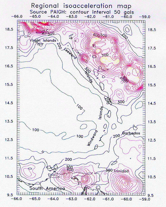
isoacceleration lines | Z factor | Zones | Zone No | Z factor | Zone No | Z factor | ||
| max | min | 1993/94 | 1993/94 | (SEAOC 80) | (UBC 88) | (SEAOC 80) | (UBC 88) | ||||
| Anguilla | 300 | 250 | 0.500 | 2.5 | 2.5 | 0.20 | 3 | 0.30 | |||
| Antigua & Barbuda | 0.750 | 3 | 0.30 | 850 | 450 | 1.000 | 4 | 4 | 0.40 | 4 | 0.40 |
| Bahamas - southern | 115 | 70 | 1 | 0.15 | |||||||
| Barbados | 0.375 | 2 | 0.15 | 225 | 175 | 0.375 | 2 | 2 | 0.15 | 3 | 0.25 |
| Belize - north | 0.500 | 2.5 | 0.20 | 200 | 120 | 2 | 0.20 | ||||
| Belize - south | 0.750 | 3 | 0.30 | 240 | 200 | 3 | 0.25 | ||||
| British Virgin Islands | 550 | 450 | 1.000 | 4 | 4 | 0.40 | 4 | 0.40 | |||
| Cayman Islands | 160 | 80 | 0.375 | 2 | 2 | 0.15 | 2 | 0.20 | |||
| Cuba | 250 | 80 | 3 | 0.25 | |||||||
| Dominica | 0.750 | 3 | 0.30 | 300 | 250 | 0.500 | 2.5 | 2.5 | 0.20 | 3 | 0.30 |
| Dominican Republic | 425 | 225 | 4 | 0.40 | |||||||
| Grenada | 0.500 | 2.5 | 0.20 | 175 | 125 | 0.375 | 2 | 2 | 0.15 | 2 | 0.20 |
| Guyana - Essequibo | 0.250 | 1.5 | 0.10 | 130 | 90 | 1 | 0.15 | ||||
| Guyana - remainder | 0.000 | 0 | 0.00 | 90 | 80 | 1 | 0.10 | ||||
| Haiti | 250 | 125 | 3 | 0.25 | |||||||
| Jamaica | 0.750 | 3 | 0.30 | 260 | 150 | 3 | 0.30 | ||||
| Montserrat | 0.750 | 3 | 0.30 | 600 | 400 | 1.000 | 4 | 4 | 0.40 | 4 | 0.40 |
| Puerto Rico | 350 | 240 | 4 | 0.40 | 4 | 0.35 | |||||
| St Kitts & Nevis | 0.750 | 3 | 0.30 | 450 | 300 | 0.750 | 3 | 3 | 0.30 | 4 | 0.40 |
| St Lucia | 0.750 | 3 | 0.30 | 175 | 150 | 0.375 | 2 | 2 | 0.15 | 2 | 0.20 |
| St Vincent & the Grenadines | 0.500 | 2.5 | 0.20 | 175 | 100 | 0.375 | 2 | 2 | 0.15 | 2 | 0.20 |
| Trinidad - NW | 0.750 | 3 | 0.30 | 370 | 300 | 0.750 | 3 | 3 | 0.30 | 4 | 0.40 |
| Trinidad - remainder | 0.500 | 2.5 | 0.20 | 370 | 300 | 0.750 | 3 | 3 | 0.30 | 4 | 0.40 |
| Tobago | 0.500 | 2.5 | 0.20 | 300 | 270 | 0.500 | 2.5 | 2.5 | 0.20 | 3 | 0.30 |
| Turks & Caicos Islands | 160 | 80 | 2 | 0.20 | |||||||
Notes:
Executive Summary | Introduction | Part 1: Guidelines for Owners | Part II: Guidelines for Maintenance | Part III: Notes for the Consulting Engineer | Appendix I | Appendix II
| CDMP home page: http://www.oas.org/en/cdmp/ | Project Contacts | Page Last Updated: 20 April 2001 |