Caribbean Disaster
Mitigation Project
Implemented by the Organization of American States
Unit of Sustainable Development and Environment
for the USAID Office of Foreign Disaster Assistance and the Caribbean Regional Program


Caribbean Disaster
Mitigation Project |
|
1.0 Supplementary Investigations
2.0 Retrofitting Actions and Cost Estimates
3.0 Proposed Design & Construction Standards
Appendix A: Report on damage to Lucelec system caused by TS
Debbie (Lucelec)
Appendix B: Bore Hole Logs
Appendix C: Information on Polycarbonate Hurricane Shutters
Appendix D: Photographs
Appendix E: Supplier Calculations, Peak Lopping Station
The Inception Report indicated the need for further investigation in several areas. These are outlined below:
| Castries: | Whether the design of the Administrative Office Building considered the potential for
liquefaction of the soil sub-strata under the building. Fixing details for the external ceramic wall cladding on the Administrative Office Building. |
| Cul-de-Sac: | Strength of the main roller shutter door on Power Station. Construction of the fuel and water tanks. Design of the Peak Lopping Station. |
| Union: | Stability of cliff face behind the Sub-station. Inspection of the Sub-station (named the "Auxiliary Plant Building" in the Inception Report). |
| Storm Surge: | Effects of this hazard on coastal sites and more accurate information on the elevations of buildings at these sites relative to mean sea level (msl). |
Additional information on most of these items was obtained during a follow-up visit to St. Lucia by Mr. Stephen Sandiford in mid-February and through subsequent inquiries. For some items, it has not been possible to obtain definitive information. The majority of these issues are dealt with in sub-section 1.3, while the effects of storm surge are outlined in sub-section 1.2.
In light of the passage of tropical storm (TS) Debbie in September 1994 a review of the torrential rain hazard (particularly at Union) was also undertaken. Further discussion of the effects of the storm is provided in sub-section 1.2.2.
The following review of selected hazards is undertaken as a result of the receipt of further information on these topics.
Figure 1 is taken from a CDMP/OAS computer model of the 1-in-100 year storm surge event for St Lucia. The model makes use of satellite imagery and data from the National Hurricane Centre on all tropical weather systems that have passed through the Caribbean region since 1886 to estimate the maximum coastline storm surges that would be generated by storms with return periods of 50 and 100 years.

For St. Lucia, the model indicates that the greatest surge heights can be expected on the east coast of the island, with a maximum of 2 to 2.5m around Port Praslin. The value given for the area around Castries (1.25 to 1.5m) is approximate as the effect of the topography of Castries harbour is not given detailed consideration in the model.
Table 1 lists the approximate heights above mean sea level of the various sites. These were obtained from 1:2500 Ordinance Survey (OSD) maps. Only facilities at Castries are likely to be affected by the 1-in-i 00-year storm surge event.
| OSD Map Ref. | Location | Approx. height above msl of site | Comments |
| 0849 | Castries: Admin. Bldg. | ~1.5m | Near the coast in Castries harbour. |
| 0848 | Castries: Sub-Station | ~1.5m | Located about 200m inland. Floor level raised a further 0.9m above ground level. |
| 1050 | Union: Sub-Station & Power Station | 7.5m to 9m | 1.5 km inland. Power Stn floor~ 1.5m above Sub-Stn floor. |
| 1216 | Vieux-Fort: Power Station | ~3m to 4.5m | On south-west coast. |
| 1020 | Vieux-Fort: Sub-Stn. | 16m to 16.5m | About 1.75km inland. |
| 0231 | Soufriere: Sub-Stn. | 16m to 24.5m | About 2km inland. |
| - | Cul-de-Sac site | 18m to 24.5m | - |
(Abbreviations: Stn = Station, bldg.= building.)
TS Debbie affected St Lucia between 9 and 10 September 1994. In addition to other damage, torrential rains associated with the storm caused widespread disruption of the transmission and distribution system, minor flooding at Cul-de-Sac and near inundation of the sub-station at Union (see LUCELEC report in Appendix A).
Meteorological data indicate that the total rainfall experienced over a 24-hour period varied from around 230mm (9") to 350mm (13.75"). At Union Agricultural Station, less than half a mile from the power station and sub-station site, about 290mm (11.25") of rain fell during that period. The 1-hour rainfall intensity for this same site peaked at around 85rnm (3.35"). These latter figures indicate rainfall in excess of the 1-in-13 year design storm (and probably in excess of the 1-in-20 year storm) for Union (ref figures 8 & 9 in the Inception Report). The severity of TS Debbie is still under discussion, having been considered a 1-in-1000 year event by some.
It should be noted that intensity: duration graphs used 'in design are limited by the length (in years) of the available reliable records of rainfall amounts. The longer the period of observation, the more reliable the estimate of intensities for various return periods. In particular, it is difficult to accurately estimate the intensities of rainfalls with large recurrence intervals from relatively short periods of records.
Although rainfall in the vicinity of Union was in excess of the likely design criteria, this would not completely explain the observed levels of flooding at the site. Most of the observed flooding in low-lying areas occurred as a result of runoff from heavy rainfall at higher elevation. Increased runoff at higher elevation may be the result of inappropriate land development.
Further discussion of the Union site is contained in sub-section 1.3.3.
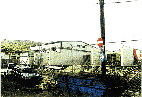
No significant flooding was reported at either of the Castries facilities as a result of TS Debbie. However, the access road east of the sub-station was reported to be temporarily under about 12" of water (photos 1 & 2).
Discussions were held with Mr. T.R. Walcott, the structural design engineer for the building. Mr. Walcott related that Canadian National Building Code earthquake criteria had been employed but there had been no consideration of earthquake-induced liquefaction of the underlying soils. It is known that saturated fine sands are very susceptible to liquefaction with loss of foundation support, localised subsidence, and damage to piles as possible consequences.
From construction reports, it has been determined that the sub-soil was mostly sand, that the material in the SW section of the site was softer than elsewhere, and that about 20% of the piles needed to be driven further (as much as 100% further) than originally expected.
Copies of the borehole logs (Appendix B is not included in the electronic version of the report. Please contact CDMP.) and soils investigation (obtained from Trintoplan Ltd) indicate that the sub-soil is predominantly a gravely-sand with significant amounts of silt and traces of organic matter to a depth of about 15-ft. This layer overlays dense weathered rock. Ground water was noted at between 2-ft to 6-ft down.
A detailed analysis of the liquefaction potential of the site does not fall within the ambit of this report. However, despite the presence of large amounts of gravel in the sub-soil, there is clearly some potential for damage as a result of this phenomenon in strong earthquakes. However, it is not felt that the cost of further investigations and the nature of any remedial work that could be attempted to forestall liquefaction effects under severe earthquake events can be justified.
The external wall cladding (3/8" thick, glazed, ceramic tiles) on the Administrative Offices was fastened using an adhesive cement. It is likely that there will be some loss of tiles under earthquake conditions. This could cause personal injury and damage to glazing and equipment.
As mentioned previously, no significant flooding was reported at the Cul de Sac compound during TS Debbie. Previous problems with flooding had occurred as a result of the blockage of cut-off drains on the hill-side above the compound. The Chief Engineer, Mr. C J Mitchell, noted that there had been recurring problems with groundwater (possibly an underground spring) in the area to the SW of the main building. Boreholes done for the peak lopping station had indicated groundwater at only 4' below the surface in this area. Care should be taken to ensure that basements are of watertight construction, especially where pipes, etc., penetrate the walls.
(See Appendix A for a description of the damage caused by TS Debbie at Cul-de-Sac).
The roller shutter door here is about 6m high x 4m wide. The guide wheels (placed at about 18" c/c along the longer edges) are held in place by shallow (1" to 2" deep) channel sections fixed to the adjacent wall. There was no channel or other fixing at the bottom of the door.
Although sturdily constructed, the lack of positive restraints may result in the door being pulled out of its tracks during a hurricane. This may readily be avoided by the provision of storm bolts/stays at the base and sides.
In the Inception Report, the opinion was given that the power station exhaust stacks are adequately constructed and fixed down to resist Category 3 hurricanes. No further investigation of these aerodynamic structures has been carried out. Such an exercise would be warranted if it is imperative that these stacks remain intact in the aftermath of a Category 4 or 5 hurricane.
The members used in the steel frame for this building were substantially smaller than those used in other buildings on the site. The design criteria required a 3-second gust wind speed of 54rn/s and stipulated that ridge ventilators were to be used. Steelwork design was to be in accordance with British Standard Code of Practice B55950.
The supplier's calculations (Appendix B is not included in the electronic version of the report. Please contact CDMP.) were carried out using the methodology of the 1981 BAPE/NCST/OAS Code of Practice for Wind Loads for Structural Design. The "BAPE" code defines a 1-in-50 year, 3-second gust (i.e. basic wind speed) for St Lucia as 58 m/s. Thus, although the stipulated design criterion of 54 m/s falls within the Saffir-/Simpson range (ref Inception Report, Sect. 2.3) for Category 3 hurricanes (50 to 58 m/s) it lies 7% below the "BAPE" requirement.
In addition, the supplier used a partial safety factor of 1.2 for the steelwork design, rather than the 1.4 recommended by B55950, for wind loading. This represents a reduction of about 14% in the partial safety factor for wind. This reduction in load factor is unorthodox and unreasonable.
CEP analysed the building using the "BAPE" and B55950 provisions. It was found that the existing structural frame will resist Category 3 winds (58 m/s (3-second gust) basic wind speed) unless a dominant opening occurs (e.g., loss of door(s) or large expanse of side sheeting). In such a case, the increase in pressures may lead to the failure of some members. The original design criteria did not specify strength requirements for the doors, nor were these items actively considered in the supplier's design. The actual strength of these elements is not known.
Oral information obtained from the Hess Oil Company, St Lucia, indicated that the tanks had been designed in accordance with the recommendations of the American Petroleum Institute and that allowances had been made for high winds. It is unknown whether these allowances are adequate. No further details on the design of these tanks has become available. However, the tanks warrant further consideration. There are examples of catastrophic failure of fuel tanks in the Caribbean under both hurricane and earthquake conditions.
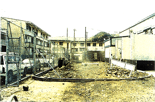
The power station and sub-station at Union are located slightly downstream of the narrowest point of the surrounding Choc River valley at perhaps 10 to 12-ft above the river bed (photos 3 to 7). The valley itself drains a substantial portion of the surrounding area: from Morne Serpent in the north to as far away as Bocage and Babonneau in the south. During TS Debbie water levels as high as 5-ft to 6-ft were reported at the power station and sub-station site. Apparently, large amounts of water only entered the sub-station building after the latch on the main metal doors failed. However, neither the doors nor windows were specifically designed to be water tight. The power station floor is about 5-ft higher than that of the sub-station and the equipment there was not affected.
Although the rainfall during the storm appeared to be higher than the likely design criteria, this in itself would not explain the observed water levels. The importance of the valley as a catchment for the area north of Castries and the location of the sub-station near the outfall were contributing factors. This site is therefore at higher risk of flooding than other locations.
Remedial measures to be considered for the protection of the sub-station against flooding might include:
Regarding the stability of the cliff face to the south of the site, geotechnical data obtained from pre-construction investigations indicate that the water table is at 3 to 4-ft below the surface of the power station site and that the underlying material is predominantly clayey to a depth of 30-ft below which a dense rock (probably basaltic) is encountered. However, no definitive statement is possible on the stability of the nearby cliff face without further extensive site investigation. In the absence of evidence of rock falls or mud slides further investigation may well not be economically justified. This issue should be revisited if unstable slope conditions develop.
Visual inspections of the sub-station (previously referred to as the Auxiliary Plant Building) and stores buildings at Union were carried out. The sub-station is of similar construction to the Castries sub-station (ref section 4.2.2 of the Inception Report) and can be expected to show equally good resistance to earthquakes and Category 3 storms.
The old stores building at Union is not normally used to stockpile any important items, however equipment destined for use at the Castries sub-station had been stored there and had been damaged by flood waters during TS Debbie. The building is composed of "trussed" steel stanchions with blockwork walls and piers. There are ventilation blocks at the eaves. The lightweight, metal roof sheeting has a favourable slope for hurricane resistance but is fixed using J-bolts. As mentioned in the Inception Report, J-bolts have a tendency to straighten out under repeated uplift loads.
If the building is to be used as a storage facility in future, it is recommended that this type of fixing be supplemented with self-tapping screws. Overall, the building is expected to show fair resistance to hurricanes and fair to good resistance to earthquakes.
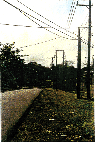
The new sub-station under construction in the Soufriere area is a small, light-weight, metal-framed structure (about the size of a commercial shipping container) clad with profiled steel sheet. It was not possible to see the actual structural framing. However, given the observed wall thickness and frequency of cladding fixings, this building might be expected to perform poorly during a Category 3 hurricane.
The building is located on a hillside about 8-ft to 12-ft above the nearby road. Flooding is not expected to be a problem at this site (Photos 8 & 9).
Table 2 summarises the vulnerable areas of each structure. These were previously described in detail in the Inception Report and sub-section 1.3 of this document. Table 3 provides rough cost estimates for the proposed retrofitting actions. These are only intended to be "order of magnitude" estimates.
Where possible, available contractors' rates for similar work were used (eg, the cost of made-up timber shutters were based on a per square foot rate). For the more labour intensive retrofitting operations (eg installing additional fixings), the emphasis was on time (translated to cost) estimates plus an allowance for material costs. The cost estimates are for actual construction only. Hidden costs, such as down time or changes in schedule to allow retrofitting work are not included. All estimates are in US dollars.
It should be noted that the recommendations are based on resistance to winds associated with a category 3 (Saffir-Simpson) storm. Design to resist 1-in-SO year (Category 3) storms is the minimum code requirement. The majority of Lucelec's facilities already exhibit good resistance to Category 3 storms and therefore the costs of this level of retrofitting are relatively low.
For facilities as critical to a small country as LUCELEC' 5 are, serious consideration should be given to providing security against hurricanes of greater than Category 3 destructive potential. For the sake of comparison, the likely costs of retrofitting to resist Category 4 storms are also included in Table 3. Retrofitting to provide this extended level of security would typically require more frequent sheeting fixings, the strengthening of steelwork members and serious attention to the ability of structures such as the exhaust stacks to resist aerodynamic excitation.
It should be noted that the costs quoted for storm shutters in Table 3 are for made-up timber shutters. As a result of Hurricane Andrew, the current edition of the South Florida Building Code requires that shutters and/or glazing comply with new impact resistant requirements. It requires that those elements in buildings below 30-ft be able to resist the impact of a large missile (in the form of a 9-pound, 2"x4" timber moving at 34mph). Several purpose-made shutters in aluminium, steel and clear polycarbonate are available which meet this requirement. Appendix C (Appendix C is not included in the electronic version of the report. Please contact CDMP.) gives information on polycarbonate shutters. Comparable costs are US$12 to 15 per square foot (installed) for polycarbonate shutters versus about US$5 per square foot (or less) for made up timber shutters.


Section 2.0 of the Inception Report outlined the types of natural hazard likely to affect St Lucia. These were:
The review of Lucelec's construction standards revealed that there was no consistent application of appropriate design criteria for natural hazards; although proposals for the new 7MW set at Cul-de-Sac do outline requirements for earthquake and windstorm.
The vulnerability assessment of the existing structures indicates that most of the buildings are capable of resisting (with relatively little modification) a Category 3 storm and that these structures also show moderate to good resistance to earthquakes. The majority of Lucelec's facilities are not likely to be seriously affected by tsunamis or storm surge and, with the possible exception of Union, torrential rains should also lead to little damage.
In light of the above, the following criteria are therefore proposed for all new construction.
Generally, all buildings/structures should be designed in accordance with the provisions of the Caribbean Uniform Building Code (CUBiC) using an Importance Factor of 1.5. Comments on earthquake detailing are contained in Section 3.6.
Design for wind loads should be carried out in accordance with the provisions of the 1981 BAPE/NCST/OAS Code of Practice for Wind Loads for Structural Design. Normally, an S3 factor of 1.0 is used. (The S3 factor is based on statistical concepts and takes account of the degree of security required and the return period of the wind speed under consideration.) Because a greater level of security is appropriate for LUCELEC's facilities, a greater S3 factor, 1.1, is recommended. For St. Lucia, this approximately represents a storm of return period 1-in-100 years.
It is also recommended that the windows and doors of all new structures comply with the impact requirements of the 1994 South Florida Building Code.
It is proposed that drainage systems be designed for the 1-in-I 00 year storm, and that careful consideration be given to identifying areas (such as Union) that are susceptible to serious flooding as a result of topographical conditions.
It is recommended that in the design of any future facilities in low-lying coastal areas (particularly on the east coast) consideration be given to the possible effects of the 1-in-100 year storm surge event. In addition, allowances should be made for the tsunami hazard. Shepherd and Smith predict a surge of 1.7 m on St. Lucia's west coast from a realistic event of the submarine volcano, "Kick 'em Jenny," which is located north of Grenada.
General guidance on the quality of work required may be provided by appropriate technical specifications. These should be tailored to the needs of the individual project and may cover areas such as:
In addition, there are many international standards which cover construction; from analysis and detailing to quality of materials. Most of LUCELEC'S recent buildings have generally been constructed in accordance with British Standard Codes of Practice. However, earthquake resistant design and detailing is not specifically referenced in the British Standards B581 10 and B55950 which cover concrete work and steel work respectively. In order to achieve satisfactory ductility levels, the detailing of all structures should be carried out in accordance with the requirements of the Structural Engineers Association of California (SEAOC).
Designers should be requested to ensure that there is consistency between the standards adopted for various aspects of work.
Maintenance in this context is not only intended to mean the upkeep of the physical facilities, but also identifies the need to keep abreast of changes in construction standards; especially in relation to design criteria. As more information on phenomena such as earthquakes and windstorms becomes available, there are likely to be changes in the requirements for the design of buildings/structures to resist these hazards. Perhaps even changes in the minimum design forces. Construction professionals employed by LUCELEC should always be required to employ standards which reflect best international practices relevant to LUCELEC's natural environment and in accordance with the company's design criteria.
The major damage to Lucelec's system occurred at Union 66/11KV Substation where the building housing the 11Kv switchgear, the 415/240V switchgear, the 66Kv and 11Kv and bus zone relay panels, the tap changer control panels, the fibre optic protection/communication panel and the 110 volt battery and charger was submerged to a dept of 5' above floor level. Virtually everything was submerged except for the 11Kv relay panel mounted above the 11KV switchgear.
There were extensive deposits of mud in the building, the cable trenches and in the 11KV switchgear and panels.
Virtually the same damage occurred to a similar set of new equipment stored in the adjacent Union Stores building. This equipment was for use in the new Castries 66/11KV Substation currently under construction.
The adjacent 66Kv switchgear compound was flooded to between 3 and 6 feet with water ingress into marshalling cubicles circuit breaker mechanisms, tap changers and other auxiliary equipment.
As soon as the flood subsided an extensive clean up and preservation exercise was put into place. This will be virtually complete by Saturday 17th and re-testing and re-commissioning of the equipment will start on Sunday 18th.
There was also considerable damage to the 11Kv and 415/240 volt networks throughout the island, briefly summarized below.
In the Roseau Valley some 29 new poles were erected, 4 poles straightened and 24 spans of new conductor run out.
On the road to the Roseau Dam some 11 poles were replaced or re-erected and 8 poles straightened.
In the Ravine Poisson area some 7 poles were replaced or straightened and large amounts of debris removed from the lines.
In the Bocage/Babonneau Marchand and Ti Rocher areas 15 poles were replaced and 4 straightened.
In the Castries area some 6 new poles were erected and 2 others straightened.
In the Soufriere area some 8 new poles were erected and two straightened.
There were also numerous service calls, problems with debris and street lights.
The estimated cost of the damage exceeds EC$500,OOO.
The Generation Department suffered relatively minor damage, Union Power Station was flooded to floor level and had extensive mud deposits. The fence was damaged, and some auxiliary electrical equipment was damaged.
There was considerable surface water flowing through Cul de Sac Power Station which damaged the emergency black start diesel, fencing and caused minor flooding in the power station basement.
The main effect on generation has been caused by the loss of the Union 66/11KV Substation and with it the 66KV link between Cul de Sac and Union Power Stations. This has necessitated a re-distribution of 11Kv loads which has given generation some problems in meeting them although this generally has been over shadowed by 11Kv feeder loading problems. It has also delayed maintenance on sets 1 and 2 at Cul de Sac.
C.J. MITCHELL
CHIEF ENGINEER
Appendices B: "Borehole Logs: Peak Lopping Station and Administrative Offices", C: "Polycarbonate Hurricane Shutters" and E: "Supplier Calculations, Peak Lopping Station" are not included in the electronic version of the report. For further information, please contact CDMP.


| CDMP home page: http://www.oas.org/en/cdmp/ | Project Contacts | Page Last Updated: 20 April 2001 |