Wave Hazard Assessment for Selected Sites on the West Coast of Dominica, West Indies


| Back to: Wave Hazard Assessment for Selected Sites on the West Coast of Dominica, West Indies |
Back to: | |
|
An initial analysis was done using bathymetry derived from the MSS satellite image, with horizontal resolution of 80 meters. This model run also used "worst case" parameters, such as assuming that the storms coincided with the astronomical high tides. After that, the model was run again with improved bathymetry derived from the SPOT image at 20-meter resolution, reinforced by digitized contours from the nautical charts, and a more realistic set of "mixed-case" parameters. The first model run produced wave heights, total water heights, and storm surges at shoreline which were 33% to 45% higher than the values based on the improved bathymetry and moderate assumptions.
The values below are from the second model run. It must be remembered that the 20-meter resolution of the digital maps does not delimit the shoreline precisely. Model output was queried at the transects for the selected sites, and the shoreline was found by extrapolation of bottom slope for the two cells closest to land. Storm parameters at the derived shoreline were developed by interpolation. Values are given to three significant figures in order to allow users to exercise judgement when rounding numbers.
| Storm Event Interval | 5 Years | 10 Years | 25 Years | 50 Years |
| Library Wall | 1.38 | 2.01 | 2.66 | 3.30 |
| Woodbridge Bay | 1.31 | 1.96 | 2.62 | 3.27 |
| Morne Daniel | 1.35 | 1.99 | 2.66 | 3.31 |
| Coulibistri | 1.36 | 2.00 | 2.65 | 3.30 |
| Gueul de Lion | 1.31 | 1.97 | 2.62 | 3.28 |
| Colihaut | 1.32 | 1.98 | 2.64 | 3.29 |
| Storm Event: Interval | 5 Years | 10 Years | 25 Years | 50 Years |
| Library Wall | 1.56 | 1.86 | 2.17 | 2.49 |
| Woodbridge Bay | 0.88 | 1.31 | 1.81 | 2.27 |
| Morne Daniel | 1.29 | 1.60 | 2.21 | 2.59 |
| Coulibistri | 1.37 | 1.75 | 2.14 | 2.53 |
| Gueule de Lion | 0.93 | 1.39 | 1.85 | 2.31 |
| Colihaut | 1.03 | 1.54 | 1.97 | 2.41 |
| Storm Event interval | 5 Years | 10 Years | 25 Years | 50 Years |
| Library Wall | 2.31 | 3.13 | 3.96 | 4.79 |
| Woodbridge Bay | 1.84 | 2.75 | 3.71 | 4.64 |
| Morne Daniel | 2.12 | 2.95 | 3.99 | 4.86 |
| Coulibistri | 2.18 | 3.06 | 3.94 | 4.82 |
| Gueule de Lion | 1.87 | 2.80 | 3.74 | 4.67 |
| Colihaut | 1.94 | 2.91 | 3.82 | 4.73 |
From the figures above, it appears that a 50-year storm event will affect all of the sites uniformly and seriously. Uniformly, because the highest total water level, at Morne Daniel, is predicted to be only 5% higher than the lowest, at Woodbridge Bay. Seriously, because the surge height of 3.30 meters and the total water height of 4.75 meters is just enough to put the coastal road in heavy surf for long stretches. From Woodbridge Bay to Canefield, from Tarou to Layou, and in many other areas, the road runs at the water’s edge, elevated only about 3 meters.
At the other end of the scale, 5-year storms may not cause much damage except where coastal structures are especially weak. The two meters of total water level is not enough to crash up onto the coastal road, and modern concrete structures should withstand these storms.
Weak structures that cause concern include gabions and the Library Wall in Roseau. Many coastal structures are built on wire gabions, baskets filled with stones. The foundation under the gabions may be concrete, cast in place over rounded cobblestones, or there may be no other foundation at all. Gabions get much of their strength from friction among the stones in the basket. The lubrication and buoyancy of storm flood waters weaken gabion structures.
The damaged retaining wall at the Roseau Library is little more than a plastering of reinforced concrete over a natural cliff of granular volcanic material. The wall is approximately ten meters high, and less than one-half meter thick. It rests on a shallow concrete foundation cast over rounded beach stones, and the foundation has been undermined. A portion of this wall 3 meters wide has fallen already, and there will be more damage at the next heavy storm.
Storms in the middle range, with 10- and 25-year recurrence intervals, require further study. These storms are strong enough to cause serious damage, but the effect is different from place to place. The total water level of 3 to 4 meters at Morne Daniel threatens to cut the road at a critical point. It is the only link between Roseau and the northern two-thirds of the country. Woodbridge Bay, less than a kilometer farther south, might survive the same storm. Woodbridge Bay is predicted to have about 10% less water. It also has a sandy beach and wider setback which will help to protect it.
The beach and setback at Woodbrige Bay bring up another point. In the tables above, Gueule de Lion appears quite similar to Woodbridge Bay. But, instead of a sandy beach, Gueule de Lion has a steep drop-off into 2 or 3 meters of water. Such details can not be resolved at the 20-meter grid size. The model is powerful, but site studies are still necessary for design. size="4"
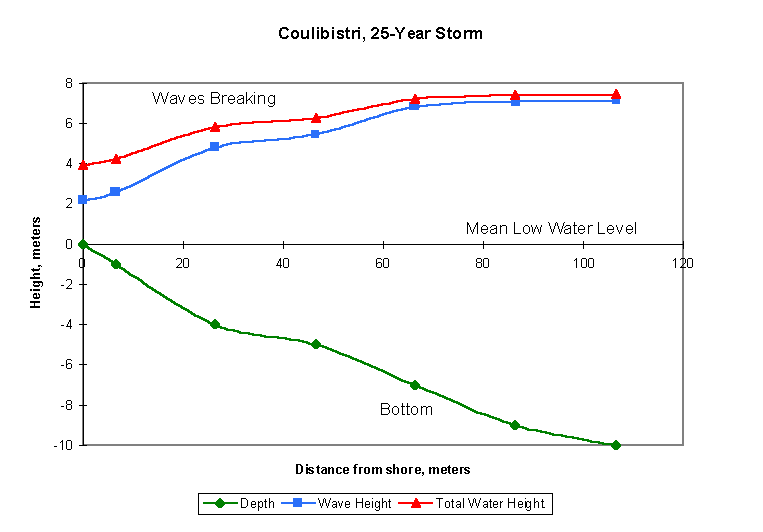
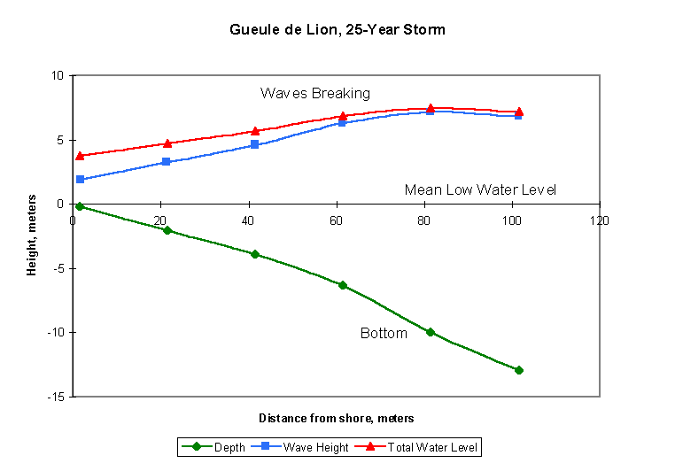
What the model does contribute to the design process is an integrated treatment of the context around each cell. Below is a graph relating the decline in wave height to the distance from shore and the depth for the transect at Library Wall.
The graph includes the bottom depth, the wave height, and the total water level for waves tops riding on a storm surge. Since all three variable are in the same units and to the same scale, it is possible to look at this graph as a profile view of the shore during the storm. The bottom rises from the ocean depths to the mean low water line, while the waves and total water height rise above the mean water level.
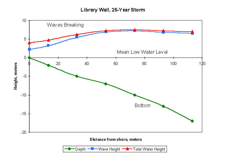
The shore at the library wall, and for some distance north and south of the library, has a uniform slope with few indentations either in this profile or in the plan view. (See site map on page 15.) The storm waves begin to break at about 75 meters from shore, where the total wave height reaches its maximum. The waves steadily lose height and energy as they approach the shore, but there is enough of them left at the shoreline to do damage.
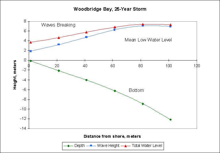
At Woodbridge Bay (below), the waves begin to break nearly ninety meters from shore. That is because the transect was run up into a cove. The depth for breaking waves is the same as at the library; about 11 meters. Again, the waves attenuate steadily over a uniform bottom slope. Less energy reaches the shore because the slope is longer.
Note however, that this graph shows only the last 100 meters, corresponding to 5 cells on the map. The gentle slope begins close to shore. The deep water port facilities, just south of the transect, project out into deep water, where the dock will have to bear the full force of the waves.
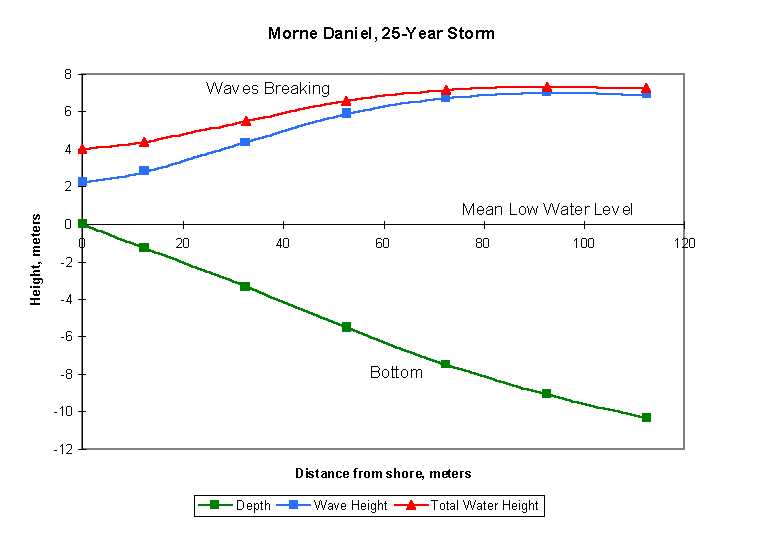
Morne Daniel is a problem area. The cliffs force the coastal road right to the edge of the water, and the underwater configuration brings deep water close to shore. For moderate storms, the rocks north and south of the sample transect help form a buffer. This profile for the 25-year storm shows how that buffer is beginning to be flooded. Waves break 90 meters offshore, and attenuate, but the curves almost level out towards the end.
Coulibistri is another problem area. Waves break very slowly, between 120 and 75 meters out. Energy is dissipated steadily from 75 to 40 meters, but the bottom does not have a steady slope. The waves travel forward from 40 to 25 meters without losing much power. As at Morne Daniel, there is an upturn of the curves near the shore. The shore is steep, and some of the wave height may be due to reflection. Looking at the plan view (page 18), it appears possible that there is also a component of energy reflected off the north shore of Grande Savanne towards Coulibistri.
Gueule de Lion has a steep but uniform bottom slope. The waves reach a distinct crest around 80 meters from shore. The trouble here has to do more with the fine details of the road construction, elements smaller than the 20-meter resolution of this model, than with the mesoscale configuration of the coast.
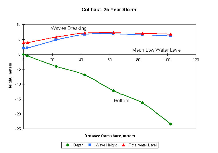
Although the damage at Colihaut was extreme in 1995, the wave height and total water level listed in Tables 9 and 10 offer little explanation. Explanation is in the graph below. The storm waves for a 25-year storm would break at 45 meters from shore, half the distance for Gueule de Lion, Morne Daniel, or Woodbridge Bay.
The waves lose height, but only by extreme turbulence and friction on the bottom. A few meters difference in the location of the shore, either in real life or on this interpolated graph, make a big difference in the power of the waves.