
Storm Surge/Wind Hazard Assessments have been completed under PGDM for Antigua, Barbuda, St. Kitts and Nevis. Maps of storm surge, wind and wave hazards for 10-, 25-, 50- and 100-year return periods are available for each island. [Storm Surge/Wind Hazard Assessment Terms of Reference] To assist with the development of a long-term database of storm hazard information, the PGDM assisted with the strengthening of existing tide gauges in Antigua and St. Kitts to increase the probability that the equipment can withstand (and record information during) a severe storm.
The introductory section for all atlases will be identical. Section A of the atlas is available in MS PowerPoint format (1,250k). A sub-regional version atlas, covering all four islands, is also available in uncompressed (MS PowerPoint 1,715k) and compressed (zip archive 1,455k) formats.
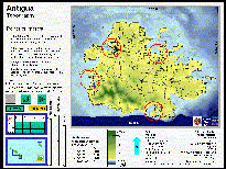
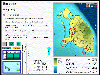
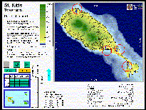
Two types of hazard maps are available: numeric maps, which show the actual expected wind, surge and wave values, and category maps, which recast these value maps into high/medium/low hazard categories. All maps are in MS PowerPoint format. The numeric maps are the most appropriate maps for use in land use planning and site selection. The category maps were used in the vulnerability assessment undertaken as part of the PGDM.
Antigua and Barbuda
|
St. Kitts and Nevis
|
| Antigua and Barbuda | St. Kitts and Nevis |
During 1998 the Caribbean: Planning for Adaptation to Global Climate Change (CPACC) installed eighteen (18) sea-level and climate monitoring stations in twelve Caribbean (CARICOM) countries. Two of the countries, Antigua and Barbuda and St. Kitts and Nevis, had sites installed at their Defense Force facilities. These installations proved to be particularly sensitive to damage from intense storms and both monitoring sites were damaged by hurricanes repeatedly after the 1998 installation. Because of the importance of these monitoring sites to the region and to the local meteorological offices, it was determined that the best course of action was to "harden" the installations to better withstand the rigors of storms.
St. Kitts and Nevis: In March 2001, the monitoring equipment was relocated from its original location on the concrete pier to the top of a steel gantry structure on the same pier. The tide gage was relocated to a more protected place with additional bracing. The additional elevation and additional bracing should increase the probability that the equipment can withstand a severe storm. The sea-level sensor was re-surveyed and the meteorological sensors were replaced with new ones.
Antigua and Barbuda: In July 2001, the monitoring equipment was relocated from its original location on the concrete pier to a site that would accommodate installing additional system height (3m) and placing guy wires on the tower. Additional brackets were added to the sea-level system. The additional height and increased bracing should increase the probability that the equipment can withstand a severe storm.
| USAID/OAS Post-Georges Disaster Mitigation: http://www.oas.org/pgdm | Page last updated on 20 Sep 2001 |