PGDM Inland Flood Hazard Map: Camps River, Nevis
A higher resolution map image
is also available (JPG 690k)
Map Text
EXPLANATORY NOTES
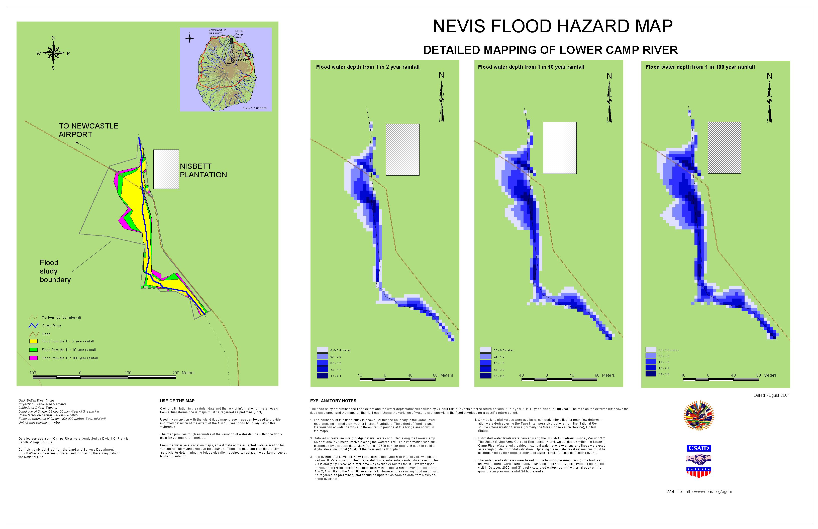
The flood study determined the flood extent and the water depth variations
caused by 24 hour rainfall events at three return periods--1 in 2 year, 1 in 10
year, and 1 in 100 year. The map on the extreme left shows the flood envelopes
and the maps on the right each shows the variation of water elevations within
the flood envelope for a specific return period.
- The boundary of this flood study is shown. Within the boundary is the Camp
River road crossing immediately west of Nisbett Plantation. The extent of
flooding and the variation of water depths at different return periods at
this bridge are shown in the maps.
- Detailed surveys, including bridge details, were conducted along the Lower
Camp River at about 25 metre intervals along the watercourse. This
information was supplemented by elevation data taken from a 1:2500 contour
map and used to build a digital elevation model (DEM) of the river and its
floodplain.
- It is evident that Nevis Island will experience the same high intensity
storms observed on St. Kitts. Owing to the unavailability of a substantial
rainfall database for Nevis Island (only 1 year of rainfall data was
available) rainfall for St. Kitts was used to derive the critical storm and
subsequently the critical runoff hydrographs for the1 in 2, 1 in 10 and the
1 in 100 year rainfall. However, the resulting flood map must be regarded as
preliminary and should be updated as soon as data from Nevis become
available.
- Only daily rainfall values were available, so hourly intensities for peak
flow determination were derived using the Type III temporal distributions
from the National Resources Conservation Service (formerly the Soils
Conservation Service), United States.
- Estimated water levels were derived using the HEC-RAS hydraulic model,
Version 2.2, The United States Army Corps of Engineers. Interviews conducted
within the Lower Camp River Watershed provided historical water level
elevations and these were used as a rough guide for model validation.
Updating these water level estimations must be accompanied by field
measurements of water levels for specific flooding events.
- The water level estimates were based on the following assumptions: (i) the
bridges and watercourse were inadequately maintained, such as was observed
during the field visit in October, 2000; and (ii) a fully saturated
watershed with water already on the ground from previous rainfall 24 hours
earlier.
USE OF THE MAP
Owing to limitation in the rainfall data and the lack of information on water
levels from actual storms, these maps must be regarded as preliminary only.
Used in conjunction with the island flood map, these maps can be used to
provide improved definition of the extent of the 1 in 100 year flood boundary
within this watershed.
The map provides rough estimates of the variation of water depths within the
floodplain for various return periods.
From the water level variation maps, an estimate of the expected water
elevation for various rainfall magnitudes can be obtained. Thus, the map can
provide a preliminary basis for determining the bridge elevation required to
replace the sunken bridge at Nisbett Plantation.
Survey and Map Information
Grid: British West Indies
Projection: Transverse Mercator
Latitude of Origin: Equator
Longitude of Origin: 62 deg 00 min West of Greenwich
Scale factor on central meridian: 0.9995
False co-ordinates of Origin: 400 000 metres East, nil North
Unit of measurement: metre
Detailed surveys along Camps River were conducted by Dwight C. Francis,
Saddle Village St. Kitts.
Controls points obtained from the Land and Surveys Department, St.
Kitts/Nevis Government, were used for placing the survey data on the National
Grid.
Dated August 2001.