A higher resolution map image is also available (JPG 305k)
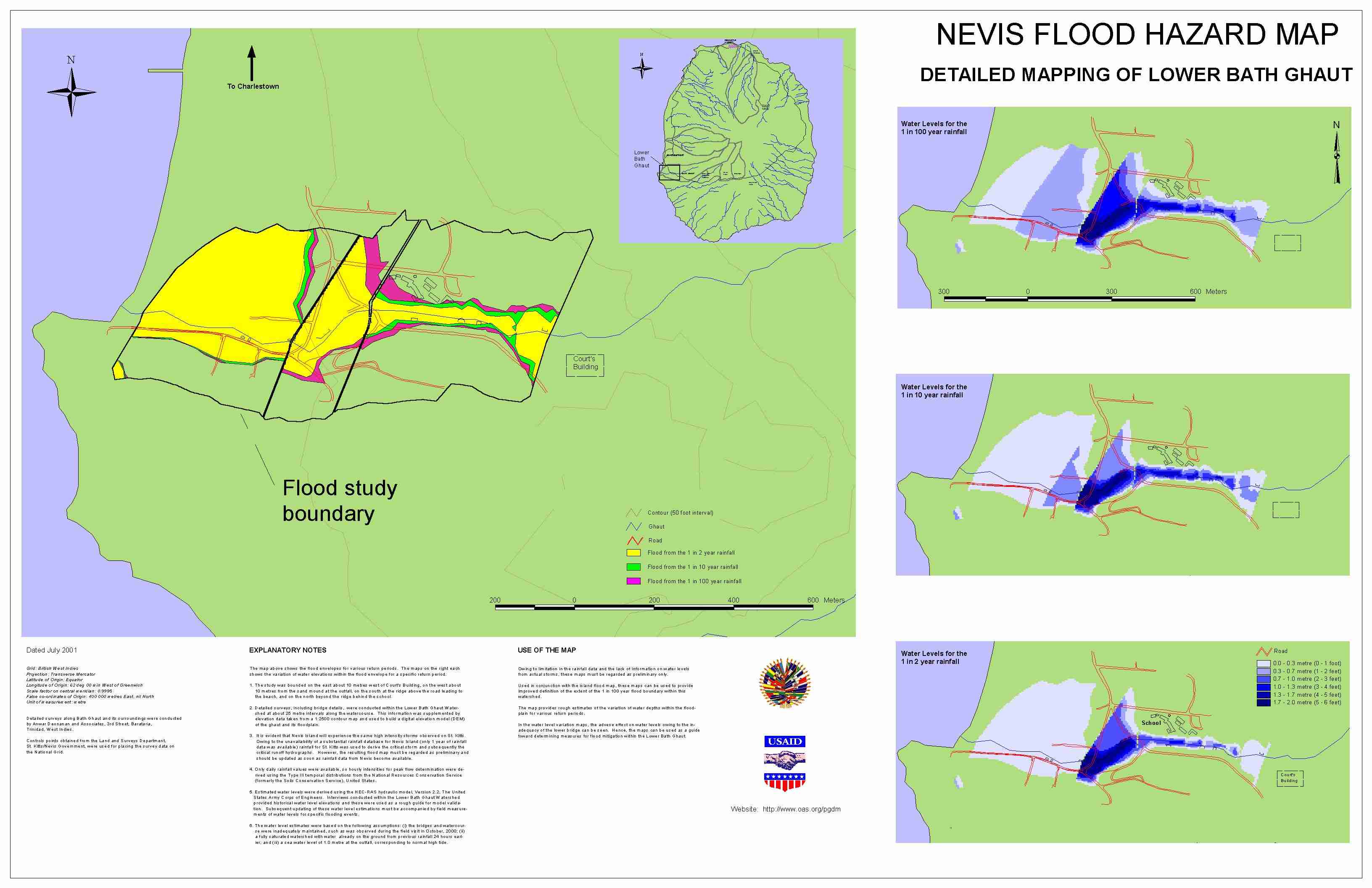
The map above shows the flood envelopes for various return periods. The maps on the right each shows the variation of water elevations within the flood envelope for a specific return period.
The study was bounded on the east about 10 metres west of Court's Building, on the west about 10 metres from the sand mound at the outfall, on the south at the ridge above the road leading to the beach, and on the north beyond the ridge behind the school.
Detailed surveys, including bridge details, were conducted within the Lower Bath Ghaut Watershed at about 25 metre intervals along the watercourse. This information was supplemented by elevation data taken from a 1:2500 contour map and used to build a digital elevation model (DEM) of the ghaut and its floodplain.
It is evident that Nevis Island will experience the same high intensity storms observed on St. Kitts. Owing to the unavailability of a substantial rainfall database for Nevis Island (only 1 year of rainfall data was available) rainfall for St. Kitts was used to derive the critical storm and subsequently the critical runoff hydrographs. However, he resulting flood map must be regarded as preliminary and should be updated as soon as data from Nevis become available.
Only daily rainfall values were available, so hourly intensities for peak flow determination were derived using the Type III temporal distributions from the National Resources Conservation Service (formerly the Soils Conservation Service), United States.
Estimated water levels were derived using the HEC-RAS hydraulic model, Version 2.2, The United States Army Corps of Engineers. Interviews conducted within the Lower Bath Ghaut Watershed provided historical water level elevations and these were used as a rough guide for model validation. Updating these water level estimations must be accompanied by field measurements of water levels for specific flooding events.
The water level estimates were based on the following assumptions: (i) the bridges and watercourse were inadequately maintained, such as was observed during the field visit in October, 2000; (ii) a fully saturated watershed with water already on the ground from previous rainfall 24 hours earlier; and (iii) a sea water level of 1.0 metre at the outfall, corresponding to normal high tide.
Note: A 100 year return period storm has a 1/100 chance of occurring in any year. Storms with high return periods, though seldom occurring, have high rainfall amounts; small return period storms, which occur frequently, have small rainfall amounts.
Owing to limitation in the rainfall data and the lack of information on water levels from actual storms, these maps must be regarded as preliminary only.
Used in conjunction with the island flood map, these maps can be used to provide improved definition of the extent of the 1 in 100 year flood boundary within this watershed.
The map provides rough estimates of the variation of water depths within the floodplain for various return periods.
In the water level variation maps, the adverse effect on water levels owing to the inadequacy of the lower bridge can be seen. Hence, the maps can be used as a guide toward determining measures for flood mitigation within the Lower Bath Ghaut.
Grid: British West Indies
Projection: Transverse Mercator
Latitude of Origin: Equator
Longitude of Origin: 62 deg 00 min West of Greenwich
Scale factor on central meridian: 0.9995
False co-ordinates of Origin: 400 000 metres East, nil North
Unit of measurement: metre
Detailed surveys along Wash Ghaut and its surroundings were conducted by Dwight C. Francis Saddle Village St. Kitts.
Detailed surveys along College Street Ghaut and its surroundings were conducted by Anwar Deonanan and Associates, 3rd Street, Barataria, Trinidad, West Indies.
Controls points obtained from the Land and Surveys Department, St. Kitts/Nevis Government, were used for placing the survey data on the National Grid.
| USAID/OAS Post-Georges Disaster Mitigation: http://www.oas.org/pgdm | Page last updated on 24 Jul 2001 |