For a more detailed view, click on the map image (medium resolution). This map is also available as a high-resolution image (Note: file size is very large: 2,810k)
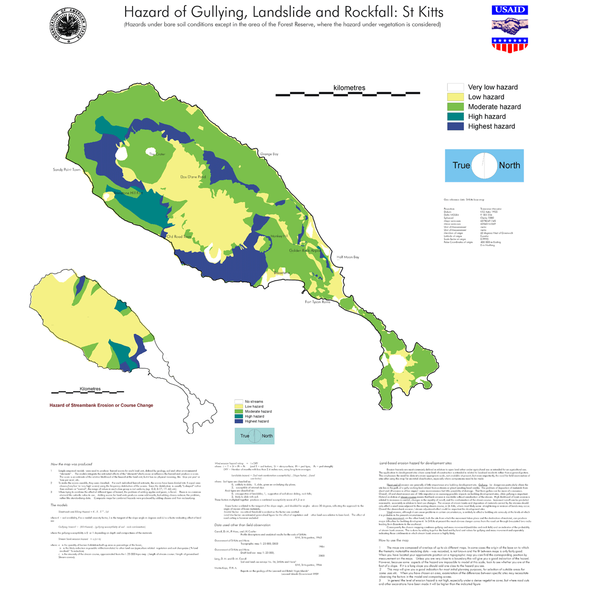
Sheetwash and Rilling Hazard = K . R . S1.55 . LU
where K = soil erodibility, R is a rainfall erosivity factor, S is the tangent of the slope angle in degrees and LU is a factor indicating effect of land use
Gullying Hazard = (Rill Hazard) . (gullying susceptibility of soil - rock combination)
where the gullying susceptibility is 0 or 1 depending on depth and compactness of the materials
Stream bank erosion hazard = c.(a+b)
where: a is the quantity of human habitation built-up area as percentage of the basin,
is the likely reduction in possible infiltrationrelated to other land use (agriculture related vegetation and soil changes)as ( % land involved * % reduction)b
c is the sinuosity of the stream course, approximated from the I: 25 000 topo map (length of stream course / length of generalised stream course).
Wind erosion hazard rating = I x DRY
where: I = T + St + Pt + Ps (and T = soil texture; St = stony surface; Pt = ped type; Ps = ped strength) and DRY = Number of months with less than 2.4 inches rain, using long term averages.
Landslide hazard = (Soil-rock combination susceptibility) . (Slope factor) . (Land use factor)
where: Soil types are classified as: 0, unlikely to slide; 1, slide, given an underlying slip plane; 2, susceptible of internal slips
Rock types are classified as: 0, unsupportive of landslides; 1, supportive of soil above sliding, rock falls; 2, likely to slide with soil.
These factors multiplied together produce a combined susceptibility score of 1,2 or 4
Slope factor is related to the tangent of the slope angle , and doubled for angles above 30 degrees, reflecting the approach to the angle of repose of loose materials,
Rainfall factor: no critical threshold is evident so the factor was omitted.
Land Use factor: an estimated generalised figure for the effect of vegetation and other land uses relative to bare land. The effect of road cutting is however excluded.
Carroll, D. M., P. Moss, and J K Coulter, Profile descriptions and analytical results for the soils of St Kitts, UWI, St Augustine, 1963
Government of St Kitts and Nevis, Topographic map 1: 25 000, E803, 1984
Government of St Kitts and Nevis, Draft land use map 1: 25 000, 2000
Lang, D. M. and D. M. Carroll, Soil and land use surveys No. 16, St Kitts and Nevis*, UWI, St Augustine, 1966
Martin-Kaye, P. H. A., Reports on the geology of the Leeward and British Virgin Islands*, Leeward Islands Government 1959
Erosion hazards are most commonly defined in relation to open land either under agricultural use or intended for an agricultural use. The application to development sites where some kind of construction is intended is related to localised incidents rather than a general picture. This emphasises the need for data at a more appropriate scale, not available at present, but more importantly, the need for field examination of sites after using this map for an initial classification, especially where comparisons need to be made.
Sheet and rill erosion are generally of little importance at a building development site. Gullying be dangerous particularly where the site lies in the path of a gully working back inland from a stream or ghaut (eroding head wards). The problem of deposition of materials from sheet and rill erosion is of low impact some inconvenience but little possibility of damage. That from gullies can be more of a nuisance. Overall, rill and sheet erosion are of little importance in assessing possible impacts on building development sites, while gullying is important.
Natural evolution of stream courses means that bank erosion is inevitable without canalisation of the stream. High likelihood of bank erosion is related to increases in rainfall, changes in the rapidity of runoff, and the conformation of the stream course. Increased runoff can be predicted reasonably accurately in relation to land use changes. The erosion of stream banks and deposition of materials carried by the streams should only affect a small area adjacent to the existing stream course, in St. Kitts, where most likely some straightening or revision of bends may occur. Overall the stream bank erosion / stream adjustment effect could be important for development sites.
Wind erosion, although it can cause problems in certain circumstances, is unlikely to affect a building site seriously at the levels at which it is probable in the present circumstances.
Mass movement, on the other hand, both the site from which the movement takes place and the destination of material, can produce major difficulties for building development. In St Kitts at present the most obvious danger comes from the road cut through brecciated lava rocks leading from Basseterre to the southeast.
Consequently the chosen mapping combines gullying and mass movement (landslides and rock falls) and an indicator of the probability of stream bank erosion. This is done by adding together the land unit by land unit values for gullying and mass movement and separately indicating those catchments in which stream bank erosion is highly likely.
Projection Transverse Mercator
Datum K12 Astro 1955
Delta WGS84 9 183 236
Spheroid Clarke 1880
Major semi-axis 6378249.145
Minor semi-axis 6356514.869
Unit of Measurement metre
Unit of Measurement metre
Meridian of origin 62 degrees West of Greenwich
Latitude of origin Equator
Scale factor at origin 0.9995
False Coordinates of origin 400 000 m Easting 0 m Northing
| USAID/OAS Post-Georges Disaster Mitigation: http://www.oas.org/pgdm | Page last updated on 22 Jun 2001 |