

This report was prepared by Philmore James, Antigua.
Background /Introduction
Methodology
Structure and Content of Hazard Maps
Results/ Discussions
Recommendations/Conclusions
Glossary of Important Terms
1.0 Hurricane Frequency between 1990 and 1999 in the Atlantic Basin.
2.0 Tropical Systems which affected Antigua and Barbuda between 1995 and 1999
3.0 Antigua – Mean Annual Rates of Coastal Change 1992-1999.
4.0 Barbuda – Mean Annual Rates of Coastal Change 1995-1999.
1.0 Erosion Hazard in Antigua.
2.0 Erosion Hazard in Barbuda
COSALC Coast and Beach Stability Project
GIS Geographical Information Systems
OAS/USDE Organization of American States, Unit for Sustainable Development and Environment
PGDM Post-Georges Disaster Mitigation
SIDS Small Island Developing State
TS Tropical Storm
UNESCO United Nations Educational, Scientific and Cultural Organization
UPR-SGCP University of Puerto Rico Sea Grant College Program
USAID-J/CAR US Agency for International Development-Jamaica/Caribbean Regional Program
Antigua and Barbuda as a Small Island Developing State (SIDS) has a fragile economy that depends heavily on coastal tourism. In addition, the country ranks high in terms of its vulnerability to tropical storms (TS) and hurricanes. Between 1995 – 1999 Antigua and Barbuda experienced four (4) major hurricanes which caused severe damage and loss to the natural environment and critical changes in the social and economic fabric of the country. While the severe weather conditions may be attributed to climate change and possible sea level rise the consequences may be rather extensive. The severe weather conditions may be related to climate variations, climate change and possible sea level rise. It is therefore critical to analyze the changes, which occur around the coastal regions of Antigua and Barbuda and where possible to predict future trends in order to determine future development policy
On 20-22 September 1998, Hurricane Georges, a category 3 storm, struck the Eastern Caribbean islands of Antigua and Barbuda and St. Kitts and Nevis causing severe damage to economic and social infrastructure of both islands.
In response to the damage from Hurricane Georges, the US Agency for International Development-Jamaica/Caribbean Regional Program (USAID-J/CAR), has established a program entitled Hurricane Georges Reconstruction and Recovery in the Eastern Caribbean specially targeting Antigua and Barbuda and St. Kitts and Nevis. The activity entitled Post-Georges Disaster Mitigation (PGDM) is the disaster mitigation capacity building component of the program. The PGDM is implemented by the Organization of American States' Unit for Sustainable Development and Environment (OAS/USDE) for USAID-J/CAR.
The goal of the PGDM program is to reduce the vulnerability of people and economic activities in St. Kitts and Nevis and Antigua and Barbuda to natural hazards, including tropical storms and related flooding, seismic and volcanic hazards, through enhanced capacity for hazard mitigation
The Fisheries Division, in 1991, established a beach monitoring program within the framework of the regional ‘Coast and Beach Stability in the Caribbean islands project’ (COSALC), sponsored by the United Nations Educational, Scientific and Cultural Organization (UNESCO) and the University of Puerto Rico Sea Grant College Program (UPR-SGCP). Nineteen (19) beaches in Antigua and six (6) in Barbuda are monitored quarterly to measure beach profiles; changes in the profile cross sectional area and the profile width are then determined. These data, collected for the selected beaches, along with other related physical, social and economic information will be utilized in this project to achieve the required objectives. Additionally, it is hoped that this project could also be used as a model for other SIDS that experience similar conditions.
This project focuses primarily on beach changes and the various causal factors, which operate within the beach zone. The impact of hurricanes, TS and different human-induced activities will also be discussed..
One of the major objectives of the Post-Georges Disaster Mitigation (PGDM) project of the Organization of American States (OAS), is the development of national goals, objectives and actions to reduce the vulnerability of Antigua and Barbuda to the effects of natural hazards. The understanding of coastal erosion hazards gained through this project will inform national coastal development and erosion hazard vulnerability reduction policies and measures for Antigua and Barbuda.
Under this contract, a hazard assessment of coastal erosion was undertaken in Antigua and Barbuda, as well as the production of a technical and a non-technical report of the coastal erosion hazard assessment for Antigua and Barbuda.
The major objectives of this project include:
The major constraints of this project include the following:
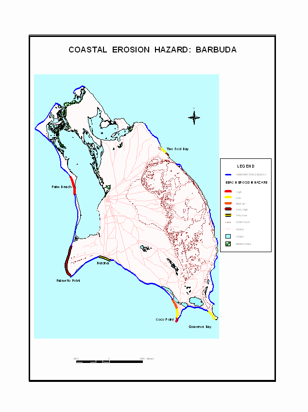
Figures 1.0 and 2.0 provide maps showing coastal erosion hazards along the beach monitoring sites of Antigua and Barbuda.
Figure 1.0 Coastal Erosion Hazard: Antigua
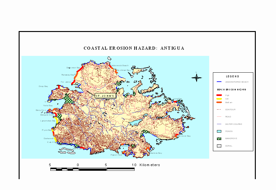
Figure 2.0 Coastal Erosion Hazard: Barbuda
Several methods and techniques were used in developing this project, namely:
Primary data collected by the Fisheries Division in its regular beach monitoring program forms the basis of this report. Nineteen beaches have been monitored in Antigua since 1992 and six in Barbuda since 1995 at quarterly intervals. Other data were obtained from the worldwide web and the Meteorological Office. Emphasis was placed on changes in the beach profile width as the primary indicator of beach change rates. If the beach profile width decreases over time, this is interpreted as an erosion rate while if the beach width increases, this is an accretion rate.
Using the Geographical Information System (GIS) layers provided by the PGDM project as a base, new layers were created to show beaches that are monitored and not monitored. Categorization was done to show the varied beach erosion hazards throughout Antigua and Barbuda
Using the beach monitoring and other data, major operational processes and activities were determined so that beaches affected by storms or other factors were identified. A coastal erosion hazard index was developed for the various beaches that are monitored around Antigua and Barbuda. The maps depict the hazard category for an individual beach or segment of the beach. The categories for the erosion index for Antigua and Barbuda are:
Rate of Coastal Change Hazard category
+3.38 to +5.28 Very low
+1.48 to +3.37 Low
- 0.43 to +1.47 Medium or Moderate
- 2.34 to – 0.44 High
- 4.25 to – 2.35 Very high
Together with the reports the hazard maps for Antigua and Barbuda form the main output of this project. The maps show erosion hazards for the various monitored beaches around Antigua and Barbuda. The base maps which show contours, roads, settlements and critical coastal habitats are drawn at a scale of 1:50,000.
The maps depict the Coastal Erosion Hazard for Antigua and Barbuda with the hazard categories shown in color for easy reference and contrast. For Antigua the relative hazard are shown as low, moderate or high while for Barbuda, where there is a greater range in the data, there are two additional categories: very low and very high, these show relatively extreme conditions.
Maps are accompanied by illustrated legends, which seek to explain the meaning of the relative rankings in both quantitative and qualitative terms.
There is a caption indicating the suggested usage and limitations of the maps. Using the given erosion rates, predictions can be made especially for short time periods. Without scientific evidence and reliable data, unmonitored beaches cannot be ranked for erosion hazard. The maps therefore do not indicate the erosion risk for beaches that are not monitored.
For up to date information on the state of the coastal areas of Antigua and Barbuda contact:
Fisheries Division
Ministry of Agriculture, Lands, Fisheries
Perry Bay
St. John’s
Antigua W.I.
Tel./Fax: 1-268-462-1372
Email: [email protected]
The logos of the sponsors or implementing agencies (USAID and OAS) are also placed on the maps. For additional information the PGDM website is given as the main contact for the project. This is shown as http://www.oas.org/pgdm.
Available data have shown that the number and intensity of tropical storms is on the increase. This is clearly illustrated in Table 1.0. Antigua and Barbuda experienced four major tropical systems during the past five years (see Table 2.0). Several beaches have changed their shape and character as a result.
Apart from the direct effects of hurricane winds, storm surge also impacted the coastline. At the monitored beaches, the changes in beach area and width result from a combination of factors including hurricane impacts.
Table 1.0 Hurricane Frequency Between 1990 and 1999
|
Five Year Period |
No. Named Storms |
No. Hurricanes Per Year |
No. Hurricane Days Per Year |
No. Category 3, 4, 5 Hurricanes Per Year |
|
1990 – 1994 |
8.4 |
4.6 |
13.6 |
1 |
|
1995 – 1999 |
13.0 |
8.2 |
41.4 |
4.0 |
Source: http://typhoon.atmos.colostate.edu/forecasts/1999/nov99/
Table 2.0 Tropical Systems, which affected Antigua and Barbuda between 1995 and 1999
|
Name |
Category |
Wind Speed (km/hr) |
Track Location |
Date |
|
Iris |
TS |
93 |
South |
27-Jul-95 |
|
Luis |
4 |
222 |
Landfall |
09-Sep-95 |
|
Marilyn |
1 |
148 |
North |
15-Sep-95 |
|
Bertha |
1 |
139 |
South |
07-Aug-96 |
|
Hortense |
1 |
130 |
North |
09-Oct-96 |
|
Erika |
1 |
130 |
North |
09-Jun-97 |
|
Georges |
3 |
185 |
Landfall |
21-Sep-98 |
|
Jose |
2 |
157 |
Landfall |
20-Oct-99 |
|
Lenny |
TS |
102 |
Landfall |
20-Nov-99 |
Note: Wind speeds are for the direct time of passage over Antigua and Barbuda
Analysis of the coastal change rates along the monitored beaches of Antigua and Barbuda indicate that erosion is the dominant process on nine beaches while the other nine show accretion.. Six beaches show marked variations along their length, in that erosion and accretion dominate on the different segments of the beach. The rate of erosion appears to be independent of the location on the island. Significantly, where there is variation between the different beach segments erosion tend to dominate along the northern end of the beach.
Most of the monitored beaches on Antigua (16) fall between the medium to high hazard category with one in the medium to low (Ffryes) and two that are fully low (Crab Hill Bay and Lignumvitae Bay). These are shown in Table 3.0.
Table 3.0 Antigua – Mean Annual Rates of Coastal Change 1992 - 1999
|
Beach |
Mean annual coastal change rate (m/yr) |
Hazard category |
|
Dickenson Bay |
-2.01 |
High |
|
Runaway Bay North |
-0.37 |
Medium |
|
Runaway Bay South |
0.71 |
Medium |
|
Fort James |
-0.50 |
High |
|
Deep Bay |
-0.55 |
High |
|
Yorks Bay |
0.59 |
Medium |
|
Stony Horn Bay |
0.21 |
Medium |
|
Mosquito Cove |
-1.47 |
High |
|
Lignumvitae Bay |
2.16 |
low |
|
Ffryes Bay North |
-0.31 |
Medium |
|
Ffryes Bay South |
1.68 |
Low |
|
Darkwood Bay North |
-0.67 |
High |
|
Darkwood Bay South |
0.52 |
Medium |
|
Crabhill Bay |
1.49 |
Low |
|
Morris Bay |
-0.71 |
High |
|
Falmouth |
0.90 |
Medium |
|
Mamora Bay |
-0.14 |
Medium |
|
Pigeon Point |
0.30 |
Medium |
|
Halfmoon Bay North |
-0.70 |
High |
|
Halfmoon Bay South |
0.19 |
Medium |
|
Long Bay |
-0.47 |
High |
|
Dutchman Bay North |
-0.34 |
Medium |
|
Dutchman Bay South |
0.66 |
Medium |
|
Jabberwock North |
-0.74 |
High |
|
Jabberwock South |
0.77 |
Medium |
The impact of storms on the beaches varies depending on several factors. These include:
Although storm impacts are emphasized, other factors play major roles in determining the erosion/accretion rates along the beaches around Antigua. The role of factors such as coastal development too close to the coastline, sand-mining, dredging, coastal protection structures, beach orientation, and relief of the nearby landscape should never be underestimated.
In the case of Barbuda with its flat, low-lying landscape there is even greater contrast in the coastal change rates. Of the six beaches monitored on Barbuda two (Two-Foot Bay and Dulcina) clearly show accretion as the dominant process, while erosion is more significant for two others (Palm Beach and Palmetto Point). The different sectors of Coco Point tend to vary with accretion dominant in the north whereas the peninsular in the south is eroding.
As depicted in Table 4.0, the hazard categories for Barbuda range from the extreme of very low (Dulcina) to very high (Palmetto Point). The location and local site conditions account mainly for the varying erosion rates.
Table 4.0 Barbuda – Mean Annual Rates of Coastal Change 1995 - 1999
|
Site |
Mean annual coastal change rate (m/yr) |
Hazard Category |
|
Gravenor Bay |
0.189 |
Medium |
|
Coco Point A |
-0.211 |
Medium |
|
Cocoa Point B |
2.916 |
Low |
|
Cocoa Point C |
-1.862 |
High |
|
Dulcina |
5.278 |
Very Low |
|
Palmetto Point |
-4.25 |
Very High |
|
Palm Bay |
-1.816 |
High |
|
Two Foot Bay |
2.689 |
Low |
Based on the nature and importance of the coastal landscape of Antigua and Barbuda there is a need to develop strategies to cope with erosion hazard vulnerability. The following measures should be considered for the future:
However, despite its obvious limitations, this analysis can still be used to inform the development of national coastal development policies and measures to reduce the vulnerability to coastal erosion hazards.
Accretion: accumulation of sand or other beach material due to the natural action of waves, currents and wind; a build-up of sand.
Beach is a zone of loose material extending from the low water mark to a point landward where either the topography abruptly changes or permanent vegetation first appear.
Beach Profile is a side view of a beach extending from the top of the dune line into the sea.
Erosion: wearing away of the land, usually by the action of natural forces.
Geographic Information System is a computer-based tool for mapping and analyzing things that exist and events that happen on earth. It is regarded as the high-tech equivalent of a map.
Hazard is the occurrence of a phenomenon (e.g. coastal erosion) which has the potential for causing damage to or loss of buildings, natural ecosystems and infrastructure.
Hazard mitigation is the set of activities implemented to minimize or eliminate the risk to property and human life from a hazard.
Risk is defined as the frequency of incidents and their associated consequences. Coastal erosion risk is the combination of the frequency of erosion along the coastline and the magnitude of associated impacts on coastal development, natural ecosystems and infrastructure.