Each year the OAS Secretary General publishes a proposed Program-Budget for the coming calendar year. The OAS General Assembly meets in a Special Session to approve the Program-Budget. Find these documents from 1998-2013 here.
Each year in April, the OAS Board of External Auditors publishes a report covering the previous calendar year’s financial results. Reports covering 1996-2016 may be found here.
Approximately six weeks after the end of each semester, the OAS publishes a Semiannual Management and Performance Report, which since 2013 includes reporting on programmatic results. The full texts may be found here.
Here you will find data on the Human Resources of the OAS, including its organizational structure, each organizational unit’s staffing, vacant posts, and performance contracts.
The OAS executes a variety of projects funded by donors. Evaluation reports are commissioned by donors. Reports of these evaluations may be found here.
The Inspector General provides the Secretary General with reports on the audits, investigations, and inspections conducted. These reports are made available to the Permanent Council. More information may be found here.
The OAS has discussed for several years the real estate issue, the funding required for maintenance and repairs, as well as the deferred maintenance of its historic buildings. The General Secretariat has provided a series of options for funding it. The most recent document, reflecting the current status of the Strategy, is CP/CAAP-3211/13 rev. 4.
Here you will find information related to the GS/OAS Procurement Operations, including a list of procurement notices for formal bids, links to the performance contract and travel control measure reports, the applicable procurement rules and regulations, and the training and qualifications of its staff.
The OAS Treasurer certifies the financial statements of all funds managed or administered by the GS/OAS. Here you will find the latest general purpose financial reports for the main OAS funds, as well as OAS Quarterly Financial Reports (QFRs).
Every year the GS/OAS publishes the annual operating plans for all areas of the Organization, used to aid in the formulation of the annual budget and as a way to provide follow-up on institutional mandates.
Here you will find information related to the OAS Strategic Plan 2016-2020, including its design, preparation and approval.
Inter-American Biodiversity Information Network (IABIN)
Development of elevation derivatives for Central America and the Caribbean using the Shuttle Radar Topography Mission (SRTM) level-2 dataset (30 meter resolution, limited distribution).
The elevation derivatives include datasets such as basins, streamlines, hill shade, slope, aspect, water flow, and water accumulation. The derivatives were produced by the U.S. Geological Survey (USGS) Center for Earth Resources Observation and Science (EROS), and the final products were provided to selected national agencies in each country, which will be responsible for completing some of the products (i.e., streamlines), labeling them, and developing metadata.
Development of digital elevation maps
Prior to the project the Central America and Caribbean region lacked integrated digital elevation data at high resolutions. The best regional dataset available was a 1Km. resolution DEM developed by the USGS (GTOPO30).
As part of the project EROS developed elevation derivatives for all the Central American and Caribbean countries (except Cuba and Trinidad and Tobago). The data was derived from the Shuttle Radar Topography Mission (SRTM) Level-2 dataset (30-meter resolution) and offers better resolution, quality and geographic scope than any dataset previously available.
The SRTM is a joint initiative of the U.S. National Geospatial-Intelligence Agency (NGA) and NASA to develop topographic data for 80% of the earth’s land mass at resolutions approaching 30 meters (http://www2.jpl.nasa.gov/srtm/).
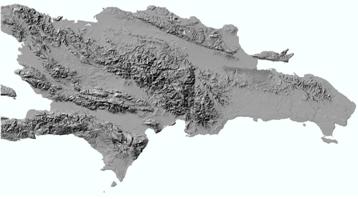
EROS was authorized to process the 30-m data for Central America and the Caribbean under an agreement with the National Geospatial-Intelligence Agency (NGA). Derived products were developed for the following countries: Panama, Costa Rica, Nicaragua, El Salvador, Honduras, Guatemala, Belize, Dominican Republic, Haiti, Jamaica, and Southern Yucatan.
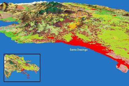
Dominican Republic SRTM Hill Shade draped over a land use/cover
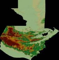
Guatemala Hill Shade
Guatemala Slope
Guatemala Aspect
The following datasets are available for each country:
Hill Shade
Slope
Aspect
Basins
Streamlines
Flow accumulation
Flow direction
Integrated regional datasets for Central America were also developed for some of the topics above.
All data products were provided to the ministries of environment and geographic institutes of participating countries. The public can also access and download them from http://geospatial.iabin.net/SRTM-Derivatives/DEM-Derived-Maps.html. Specialists from all the countries mentioned above received training on the development of these datasets during a workshop that took place in March 2006 in Panama.