- English
- Español


Integrated Water Resources Management
Past Projects
Publications
Integrated Management of land based activities in the São Francisco River Basin
Background
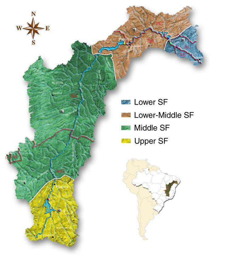
 The São Francisco River Basin (SFRB) extends over approximately 640,000 km2 of land and is the third largest river basin in Brazil. It covers a large portion of the so called “drought polygon” of Northeastern Brazil, crossing climatic zones ranging from humid to arid, flowing through five states in the country (Alagoas, Bahia, Minas Gerais, Pernambuco, and Sergipe, plus the Federal District and State of Goiás at the headwaters of tributary streams). Land-based activities in these riparian1 states include mining, agricultural, urban and industrial activities, all of which deposit contaminants into the river system, which eventually reach the coastal zone.
The basin is divided into
the upper, middle, lower middle, and lower sub-basins, plus the oceanic end
point, each with distinct environmental and socioeconomic characteristics. The
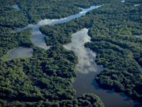
estuarine2 wetlands located at the debouchments3 of the river in the South West
Atlantic form a particularly important and environmentally sensitive habitat.
The ecological structure and function of this habitat, as well as its physical
integrity, is currently under threat due to unsustainable hydrological management and land use practices within the basin. Some 13 million people are resident in this basin, principally concentrated in the upper sub-basin.
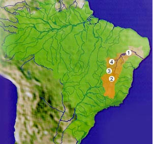
Rivers in the Basin
- 1. Rio Sao Francisco
- 2. Rio das Velhas
- 3. Rio Preto
- 4. Rio Grande
Challenges
The priority environmental concerns in the SFRB include soil loss and contamination by organic pollutants and heavy metals, both of which will be systematically identified and quantified through the activities of this project. The SFRB is a very complex area, in which development has occurred in a historically haphazard and sectoral manner, with relatively little integrated planning, and within a rather weak institutional framework. This has resulted in less than optimal use of its water resources, as well as degradation of the coastal zone, the root causes of which will be identified during this project.
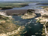
Serious environmental problems identified in the upper sub-basin consist of the direct discharge of untreated municipal effluents4 and industrial and mining waste matter containing heavy metals and cyanides. In addition, deforestation is occurring on a large scale due to the demand for charcoal and the clearing of land for agricultural use and mining. There is also widespread use of agro-chemicals. Furthermore, river contamination and the existence of large and medium size dams negatively impact fish and aquatic fauna in this sub-basin. In the middle sub-basin, environmental problems, while limited in comparison to the other sub-basins, include water quality problems, land degradation, and accelerating erosion and desertification. Environmental issues in the lower-middle sub-basin include water quality problems, contaminant deposition in reservoirs, impaired fish migration, high rates of soil erosion due to agricultural activities, contamination of surface and ground waters by runoff from irrigated lands, and modification of river basin and estuarine geomorphology due to the presence of flow regulation structures.
All of these upstream problems contribute to, or are related to, environmental problems in the lower sub-basin and coastal zone which include: sedimentation; eutrophication5 in the reservoirs; oligotrophication6 of coastal waters; alteration of river flow regimes; reductions in numbers and diversity of fish populations and populations of threatened and endangered species, such as the sea turtle which nests along the coast; and increased incidence of endemic diseases.
Project Goals
The main objective of the São Francisco project is to promote sustainable development of the SFRB and its coastal zone and address the physical, biological, chemical, and institutional root causes of progressive degradation affecting the basin. This will be accomplished by developing a Strategic Action Program (SAP) for the integrated management of the São Francisco River Basin and its coastal zone. The project focuses on the identification and implementation of appropriate economic instruments and the incorporation of land-based environmental concerns affecting the coastal zone into the future federal and state development policies, plans, and programs. The project serves as a demonstration project for the implementation of the Global Plan of Action for the Protection of Marine Environment from Land-Based Activities in Latin America.
The project design, based on extensive public consultation carried out through regional planning workshops, comprises four components: (i) River basin and coastal zone environmental analysis; (ii) Public and stakeholder participation; (iii) Organizational structure development; and (iv) Watershed Management Program formulation. In addition, the following crosscutting issues permeate the project execution: information sharing and dissemination; quantification of water use, use conflicts, and hydrological management; and financial mechanisms. The project has been executed in direct partnership with four federal institutions, three state bodies, four universities, and four NGOs, in the context of institutional participation of more than 450 institutions.
Location of the Project
How are we going to face this challenges?
The present project is designed to support an integrated approach in the planning and management of the SFRB and its coastal zone. Integrated sustainable management and development of the basin will generate significant environmental benefits to the region and potential global benefits through demonstration of integrated approaches to freshwater basin and coastal zone management.
Specific results include:
- Improve river basin and coastal zone environmental concerns, public and scientific awareness, and knowledge within the basin and its coastal zone.
- Improve public and stakeholder participation through hands-on involvement of communities in the remedial measures.
- Improve organizational structure and staffing capabilities needed to implement financial mechanisms for water rights and water charges, as provided for under federal law 9433/97.
- Improve quantification of Water Use, Use Conflicts and Hydrological Management.
- Improve integrated management and environmentally sustainable development of the SFRB.
Partners
- Funding source: Global Environment Facility - GEF
- GEF Implementing Agency: United Nations Environmental Programme (UNEP)
- Executing Agency: Organization of American States
- National Executing Agency: National Water Agency (ANA), Brazil
Resources
- Integrated Management of Land-based activities in the São Francisco Basin
- São Francisco River Basin Brochure, Organization of American States
Vocabulary
- 1 riparian: a person who owns land on the bank of a natural water course or body of water.
- 2 estuarine: part of the mouth or lower course of a river in which the river’s current meets the sea's tide.
- 3 debouch: to flow from a small valley into a larger one.
- 4 effluent: sewage or other liquid waste that is discharged into a body of water, etc.
- 5 eutrophication: (of a lake) characterized by an abundant accumulation of nutrients that support a dense growth of algae and other organisms, the decay of which depletes the shallow waters of oxygen in summer.
- 6 oligotrophication: the process of nutrient depletion, or reduction in rates of nutrient cycling, in aquatic ecosystems as a consequence of acidification.