![]()
![]()
![]()
![]()
![]()
Institutional analysis
Procedure for targeting a development strategy
Legislation
Procedure for creating units of the system
Evaluation
Establishment of regulations and penalties
Finance
Personnel
Training recommendations
Appendix I - Existing legislation relevant to natural and cultural areas protection
Appendix II - Specific policies for management categories. the national parks and protected areas system of Grenada
![]()
The National Parks and Protected Areas Program fits in directly with the economic development of Grenada. With Agriculture, Fisheries, and Tourism making up the vast majority of Grenada's GDP and foreign exchange earnings, a protected areas program can provide a broad variety of benefits to the country because of it's vital support for and linkages to these three sectors.
Given the tight fiscal constraints and that the Government is streamlining the Civil Service, the creation of a new management agency is not feasible. Establishment and management of a protected areas system must be based on existing institutions and personnel. All relevant institutions were examined in terms of their policy and objectives, legislation, programs, projects and principal activities, staffing, training, inter-agency collaboration and coordination, control and regulation of state lands or waters, and technical, financial, and administrative constraints.
The Forestry Department was chosen as the most appropriate institution to manage the National Parks and Protected Areas System. This decision was made by a committee made up of representatives from the Forestry Department, Fisheries Division, Land-use and Water Resources, The National Trust, The Historical Society, The Ministry of Education and Culture, and The Organization of American States.
Forestry was chosen because it has the following:
(a) legislation and formal policy which charge it with protecting the nation's fauna, flora, habitats, forests, watersheds and soil and water resources in order to fulfill a series of sustained production, recreation and conservation objectives and the establishment of terrestrial reserves to accomplish those ends;(b) a notable series of well-designed projects being executed with success, several of which deal with management of an existing forest reserve (proposed Grand Etang National Park) and a multiple use area (Annandale Watershed);
(c) a motivated, active staff with very basic training in forestry, and which is dedicated to the concept of a protected areas program and system;
(d) demonstrated ability to obtain international and national funding and technical assistance and use it effectively and efficiently;
(e) excellent collaborative relationships with many other national agencies;
(f) a basic physical plant and equipment including recently renovated offices, a visitors interpretation center in the proposed Grand Etang National Park, vehicles, field gear etc; and
(g) effective control of several areas given it by Government.
With the gradual addition of certain personnel and a well-designed and executed training program, Forestry could manage most of the system: national parks, natural landmarks, cultural landmarks and multiple use management areas.
The Fisheries Division will assist Forestry in the management of Protected Seascapes and multiple use marine areas. As they have offices in each of the Parishes and in Carriacou, Fisheries has agreed to work closely with Forestry to facilitate in every way the establishment and management of the program.
To advise the Forestry Department on the restoration and management of Cultural Landmarks, the formation of a Cultural Landmarks Steering Committee has been proposed. The Ministry of Education and Culture are to provide technical and logistical support through the UNESCO office. In conjunction, the Historical Society and National Trust will nominate a Chairman of the Cultural Landmarks Steering Committee. Utilizing the National Trust Act of 1967, this team will attract outside funding, oversee the restoration of the cultural landmarks, and design educational programs.
The Agricultural Extension Division has the responsibility to patrol the protected areas on a regular basis to ensure squatting, cropping of wood products or wildlife, hunting, sandmining or any other activity which adversely affects the resource is prohibited or regulated as indicated in the management category. The Extension Officers will report any infraction to the appropriate authorities in the Forestry and/or Fisheries Division. It is recommended that in order to give the Extension Officers the necessary power to carry out this function that they be named Auxiliary Wardens.
The Extension Officers will be trained in their new duties by annual workshops which will be held to inform them of boundaries, regulations, goals and objectives of the Protected Areas Program.
The Horticulture Division with planning and supervision from the Forestry Department, Fisheries Division, and Cultural Landmarks Steering Committee will help to maintain the grounds around the visitor centers and cultural landmarks and to maintain where needed the trail systems. It is recommended that twenty (20) full time labourers from the Ministry of Works begin work on the restoration of Fort George, Fort Frederick, Carib's Leap and other public sites.
The Land-Use and Water Resources Division will contribute to the effective analysis of the protected areas by incorporating them into the land-use capability and integrated watershed management studies presently being conducted. The Protected Areas Policy strengthens the mandate of the Division specifically in the promotion of suitable land-use practices in the multiple use areas.
The Land Division should work closely with Forestry Department to resolve issues of land tenure. People who own land within Protected Areas will be contacted and alternatives will be researched to encourage that the areas remain in a natural state.
The Tourism Department will develop promotional materials and campaigns to attract visitors and citizens to use the Protected Areas for recreation and education. They will help to train tour guides concerning the importance, objectives, resources, facilities, and regulations of the Protected Areas.
The Education Department and Curriculum Development Unit will assist in the development of environmental and cultural resources and education curricula as integral parts of the social studies and science curricula and will promote training of teachers to utilize the curricula.
The Science and Technology Council will promote, coordinate and carry out key research needed for the planning and management of Protected Areas and promote public awareness and environmental education.
The Mirabeau Farm School is encouraged to add a course in integrated watershed planning and management which would include a solid emphasis on Protected Areas.
The Historical Society/National Trust/Cultural Landmarks Steering Committee - will be important to advise the Forestry Division on the development, management, and maintenance of Cultural Landmarks.
TABLE X INSTITUTIONAL ARRANGEMENTS FOR THE MANAGEMENT OF A PROTECTED AREAS SYSTEM IN GRENADA
TABLE XI - ESTABLISHMENT AND MANAGEMENT OF A SYSTEM OF NATIONAL PARKS AND PROTECTED AREAS
RESPONSIBILITY MATRIX
MINISTRIES, DIVISION & PRIVATE GROUPS
|
Primary Responsibilities* |
Forestry |
Fisheries |
Education and Curric. Dev. |
Tourism |
Horticulture |
Land-use |
Lands and Surveys |
Agricultural Extension |
Farm School |
Historical Society |
National Trust |
Cultural Landmarks Steering Committee |
Min. of Works |
Coast Guard |
Grenada Hotel Assoc. |
Science & Technology |
Council |
|
Promote, coordinate and conduct research on protected areas |
* |
* |
|
|
|
|
* |
|
|
|
|
|
|
|
|
* |
|
|
Promote and monitor education, research and environmental study opportunities |
* |
* |
|
|
|
|
|
|
|
|
|
* |
|
|
|
* |
|
|
Conserve biological diversity |
* |
* |
|
|
|
|
|
|
|
|
|
|
|
|
|
|
|
|
Monitor and control land use practices that can adversely affect protected areas |
* |
* |
|
|
|
|
|
|
|
|
|
|
|
|
|
|
|
|
Provide recreation, interpretation and tourism services |
* |
* |
|
* |
|
|
|
|
|
|
|
|
|
|
* |
|
|
|
Protect cultural sites and areas of historical and archaeologic significance |
* |
|
|
|
|
|
|
|
|
|
* |
* |
|
|
|
|
|
|
Protect and conserve scenic beauty and open space |
* |
* |
|
|
|
|
|
|
|
|
|
|
|
|
|
|
|
|
Produce timber, forage or marine products on sustained yield basis |
* |
* |
|
|
|
|
|
* |
|
|
|
|
|
|
|
|
|
|
Maintain open options, management flexibility; permit multiple use |
* |
* |
|
|
|
|
|
* |
|
|
|
|
|
|
|
|
|
|
Stimulate rational, sustainable use of marginal areas and rural development |
* |
* |
|
|
|
|
|
* |
|
|
|
|
|
|
|
|
|
|
Provide a cadre of trained educators to interpret the cultural and natural heritage of Grenada |
* |
* |
* |
* |
|
|
|
|
* |
|
|
|
|
|
|
* |
|
|
Provide a cadre of trained rangers to patrol and protect cultural and protected areas |
* |
* |
|
|
|
|
|
* |
|
|
|
|
|
* |
|
|
|
|
Identify critical areas to incorporate into a System of National Parks and Protected Areas |
* |
* |
|
* |
|
* |
|
|
|
|
* |
* |
|
|
|
|
|
|
Research land tenure and approach land owners to donate or sell critical conservation areas |
* |
* |
|
|
|
|
* |
|
|
|
|
|
|
|
|
|
|
|
Advise Forestry and Fisheries on cultural landmark development, protection and maintenance |
|
|
|
* |
|
|
|
* |
* |
* |
* |
|
|
|
|
|
|
|
Maintain protected areas infrastructure; maintain protected areas ground and trails |
* |
* |
|
|
* |
|
|
|
|
|
|
* |
|
|
|
|
|
|
Identify critical areas to incorporate into a System of National Parks and Protected Areas |
* |
* |
|
* |
|
* |
|
|
|
* |
* |
|
|
|
|
|
|
|
Research land tenure and approach land owners to donate or sell critical conservation areas |
* |
* |
|
|
|
|
* |
|
|
|
|
|
|
|
|
|
|
|
Advise Forestry and Fisheries on cultural landmark development, protection and maintenance |
|
|
* |
* |
|
|
|
|
* |
* |
* |
|
|
|
* |
|
|
|
Maintain protected areas infrastructure; maintain protected areas grounds and trails |
* |
* |
|
|
* |
|
|
|
|
|
|
* |
|
|
|
|
|
TABLE XII - POTENTIAL USE OF PROTECTED AREAS (Excluding Cultural Landmarks)
4-Excellent
3-Good
2-Fair
0-Insignificant
|
PROTECTED AREA |
Protection of Unique Resources |
Endangered Species Habitat Conservation of Ecosystems |
Recreation |
Tourism |
Education |
Research |
Wood |
Forage |
Fauna |
Water |
|
|
|
HIGH NORTH |
4 |
4 |
4 |
4 |
4 |
4 |
2 |
3 |
4 |
3 |
NATIONAL PARK |
36 |
|
GRAND ETANG |
4 |
4 |
4 |
4 |
4 |
4 |
2 |
0 |
3 |
4 |
33 |
|
|
LEVERA |
4 |
4 |
4 |
4 |
4 |
3 |
2 |
2 |
3 |
3 |
33 |
|
|
MT. ST. CATHERINE |
3 |
2 |
2 |
2 |
0 |
2 |
0 |
0 |
3 |
4 |
18 |
|
|
MARQUIS ISLAND |
3 |
3 |
3 |
3 |
2 |
2 |
0 |
2 |
3 |
0 |
NATURAL LANDMARK |
21 |
|
ANNANDALE FALLS |
2 |
2 |
4 |
4 |
3 |
2 |
0 |
0 |
2 |
3 |
22 |
|
|
LA BAYE ROCK |
3 |
3 |
3 |
3 |
2 |
3 |
0 |
0 |
4 |
0 |
21 |
|
|
MARQUIS FALLS |
2 |
2 |
3 |
3 |
2 |
2 |
0 |
0 |
3 |
3 |
20 |
|
|
LAKE ANTOINE |
4 |
3 |
3 |
3 |
3 |
3 |
2 |
3 |
2 |
3 |
29 |
|
|
|
|
|
|
|
|
|
|
|
|
|
|
|
|
CONCORD FALLS |
3 |
2 |
3 |
3 |
2 |
2 |
2 |
2 |
3 |
4 |
26 |
|
|
RIVER SALLEE |
3 |
0 |
2 |
3 |
2 |
2 |
0 |
0 |
2 |
2 |
16 |
|
|
HOG ISLAND |
4 |
4 |
2 |
2 |
3 |
3 |
0 |
3 |
4 |
0 |
25 |
|
|
QUARANTINE POINT |
2 |
2 |
3 |
3 |
3 |
2 |
0 |
0 |
2 |
0 |
17 |
|
|
NORTHERN SEASCAPE |
3 |
3 |
4 |
4 |
3 |
3 |
0 |
2 |
3 |
3 |
PROTECTED SEASCAPE |
28 |
|
SOUTHERN SEASCAPE |
3 |
3 |
2 |
2 |
3 |
3 |
0 |
2 |
3 |
3 |
24 |
|
|
CALIVIGNY ISLAND |
2 |
3 |
3 |
3 |
2 |
2 |
0 |
3 |
3 |
0 |
21 |
|
|
CANOE BAY |
3 |
2 |
3 |
3 |
2 |
2 |
0 |
2 |
3 |
0 |
20 |
|
|
LA SAGESSE |
3 |
4 |
3 |
4 |
4 |
4 |
2 |
3 |
3 |
3 |
33 |
|
|
TYRREL BAY |
3 |
4 |
2 |
2 |
3 |
4 |
2 |
2 |
3 |
3 |
28 |
|
|
SALINE/WHITE ISLANDS |
4 |
4 |
3 |
3 |
3 |
3 |
0 |
2 |
3 |
0 |
25 |
|
|
LAURISTON MABOUYA |
|
|
|
|
|
|
|
|
|
|
|
|
|
SANDY ISLAND |
3 |
3 |
3 |
4 |
3 |
3 |
2 |
3 |
3 |
2 |
29 |
|
|
LIMLAIR-THIBAUD |
2 |
2 |
3 |
3 |
3 |
1 |
2 |
3 |
2 |
3 |
24 |
|
|
SABAZAN |
2 |
2 |
2 |
3 |
3 |
3 |
2 |
2 |
2 |
0 |
21 |
|
|
MOLINERE REEF |
4 |
4 |
4 |
4 |
4 |
4 |
0 |
0 |
4 |
0 |
28 |
|
|
ANNANDALE |
2 |
2 |
3 |
4 |
2 |
2 |
2 |
2 |
3 |
4 |
MULTIPLE USE |
26 |
|
CONCORD |
2 |
2 |
3 |
4 |
2 |
2 |
2 |
2 |
3 |
4 |
26 |
|
|
CHEMIN RIVER |
2 |
2 |
2 |
2 |
2 |
2 |
2 |
2 |
3 |
4 |
23 |
|
|
MT. HOPE/CLABONY |
2 |
2 |
2 |
2 |
2 |
2 |
2 |
2 |
3 |
4 |
23 |
|
|
GRAND ETANG |
3 |
2 |
2 |
2 |
2 |
2 |
4 |
0 |
3 |
4 |
FOREST RESERVE |
24 |
|
CENTRAL RANGE & BELLE VUE SOUTH |
2 |
2 |
2 |
2 |
2 |
2 |
3 |
0 |
3 |
3 |
21 |
TABLE XIII - ECOSYSTEM ANALYSIS OF PROTECTED AREAS
1-Insignificant
2-Significant
3-Good
4-Very Good
5-Excellent
|
|
NATURAL REGIONS |
TERRESTRIAL ECOSYSTEMS |
AQUATIC ECOSYSTEMS |
GEOMORPHOLOGIC VALUES FORMATIONS |
UNIQUE |
TOTAL |
|||||||||||||||
|
Caribbean Sea (Leeward) |
Littoral - Beach |
Cordillera |
Atlantic Ocean |
Tropical Dry Thorn scrub |
Tropical Dry Forest |
Tropical Moist |
Lower Montane |
Montane |
Elfin Woodland |
Lakes |
Marshes - Bogs |
Mangroves - Mudflats |
Estuary |
River systems |
Volcanic Unique Site |
Scenic Beauty |
Flora/Fauna |
Uniqueness |
Historical/Cultural Value |
||
|
High North |
5 |
5 |
5 |
5 |
5 |
5 |
|
|
|
|
|
|
5 |
2 |
2 |
5 |
5 |
5 |
5 |
5 |
67 |
|
Grand Etang |
|
|
|
5 |
|
|
|
5 |
5 |
5 |
5 |
5 |
|
|
5 |
5 |
5 |
5 |
5 |
3 |
58 |
|
Levera |
5 |
|
5 |
3 |
5 |
5 |
2 |
|
|
|
|
|
5 |
3 |
2 |
4 |
5 |
5 |
5 |
2 |
56 |
|
Saline/White Islands |
5 |
5 |
5 |
2 |
5 |
|
|
|
|
|
|
3 |
5 |
2 |
|
5 |
5 |
5 |
5 |
2 |
54 |
|
Mt. St. Catherine |
|
|
|
5 |
|
|
5 |
5 |
5 |
|
|
|
|
|
|
5 |
4 |
4 |
5 |
|
38 |
|
Northern Seascape |
5 |
|
5 |
|
5 |
3 |
|
|
|
|
|
3 |
4 |
5 |
4 |
1 |
5 |
4 |
2 |
|
41 |
|
Lauriston-Mabouya |
|
5 |
4 |
|
5 |
|
|
|
|
|
|
|
5 |
3 |
1 |
2 |
5 |
3 |
2 |
|
35 |
|
Tyrrel Bay |
|
3 |
|
|
4 |
|
|
|
|
|
|
|
5 |
2 |
|
|
3 |
4 |
4 |
|
25 |
|
Hog Island |
5 |
|
5 |
2 |
4 |
|
|
|
|
|
|
|
3 |
|
|
3 |
5 |
4 |
2 |
1 |
34 |
|
La Sagesse |
5 |
|
5 |
|
5 |
5 |
|
|
|
|
|
|
4 |
5 |
5 |
3 |
5 |
4 |
4 |
|
48 |
|
Southern |
5 |
|
2 |
|
3 |
|
|
|
|
|
|
|
3 |
5 |
3 |
|
3 |
4 |
3 |
|
30 |
|
Southern |
5 |
|
2 |
|
3 |
|
|
|
|
|
|
|
3 |
5 |
3 |
|
3 |
4 |
3 |
|
30 |
|
Seascape |
|
|
|
|
|
|
|
|
|
|
|
|
|
|
|
|
|
|
|
|
|
|
Molinere Reef |
|
5 |
|
|
4 |
|
|
|
|
|
|
|
|
|
|
|
5 |
4 |
5 |
|
23 |
|
La Baye Rock |
5 |
|
|
|
5 |
|
|
|
|
|
|
|
|
|
|
3 |
4 |
3 |
3 |
|
23 |
|
Limlair/ |
3 |
|
3 |
|
3 |
|
|
|
|
|
|
|
2 |
2 |
|
|
3 |
2 |
2 |
5 |
25 |
|
Thiboud |
|
|
|
|
|
|
|
|
|
|
|
|
|
|
|
|
|
|
|
|
|
|
Calivigny |
5 |
|
5 |
2 |
4 |
|
|
|
|
|
|
|
3 |
|
|
3 |
5 |
4 |
2 |
2 |
35 |
|
Island |
|
|
|
|
|
|
|
|
|
|
|
|
|
|
|
|
|
|
|
|
|
|
Lake Antoine |
|
|
|
2 |
3 |
|
|
|
|
|
5 |
4 |
|
|
|
5 |
4 |
2 |
5 |
3 |
33 |
|
Sabazan |
3 |
|
2 |
|
|
|
|
|
|
|
|
|
|
|
|
|
3 |
|
3 |
4 |
15 |
|
Marquis Island |
4 |
|
3 |
|
4 |
|
|
|
|
|
|
|
|
|
|
5 |
5 |
4 |
5 |
2 |
32 |
|
Annandale Falls |
|
|
|
4 |
|
|
|
|
|
2 |
|
|
|
|
5 |
5 |
4 |
2 |
3 |
2 |
27 |
|
Marquis River |
|
|
|
|
|
|
|
3 |
|
|
|
|
|
|
5 |
1 |
3 |
2 |
3 |
2 |
19 |
|
Concord Falls |
|
|
|
|
|
|
|
|
|
3 |
|
|
|
|
5 |
2 |
4 |
3 |
4 |
2 |
23 |
|
Quarantine |
|
4 |
|
|
3 |
|
|
|
|
|
|
|
|
|
|
5 |
4 |
2 |
3 |
2 |
23 |
|
Point |
|
|
|
|
|
|
|
|
|
|
|
|
|
|
|
|
|
|
|
|
|
|
River Sallee |
|
|
|
|
|
|
|
|
|
|
|
|
|
|
3 |
|
2 |
5 |
5 |
|
15 |
|
Canoe Bay |
4 |
|
3 |
|
3 |
|
|
|
|
|
|
|
|
|
|
2 |
5 |
4 |
4 |
3 |
28 |
|
CULTURAL LANDMARKS |
|
|
|
|
|
|
|
|
|
|
|
|
|
|
|
|
|
|
|
|
|
|
Fort George |
|
|
|
|
3 |
|
|
|
|
|
|
|
|
|
|
5 |
|
3 |
5 |
5 |
21 |
|
Fort Frederick |
|
|
|
|
|
|
|
|
|
3 |
|
|
|
|
|
|
4 |
|
5 |
5 |
17 |
|
The Tower |
|
|
|
|
|
|
|
|
|
|
|
|
|
|
|
|
4 |
|
5 |
4 |
13 |
|
Carib's Leap |
|
|
|
|
|
|
|
|
|
|
|
|
|
|
|
|
3 |
|
5 |
5 |
13 |
|
Petroglyphs |
|
|
|
|
|
|
|
|
|
|
|
|
|
|
|
|
2 |
|
5 |
5 |
12 |
|
La Pointe |
|
|
|
|
|
|
|
|
|
|
|
|
|
|
|
|
2 |
|
3 |
4 |
9 |
|
Belair |
|
|
|
|
|
|
|
|
|
|
|
|
|
|
|
|
3 |
|
3 |
4 |
10 |
|
Fossil Beds |
|
|
|
|
|
|
|
|
|
|
|
|
|
|
|
3 |
3 |
|
5 |
4 |
15 |
|
Dover Ruins |
|
|
|
|
|
|
|
|
|
|
|
|
|
|
|
|
3 |
|
3 |
4 |
10 |
|
Marquis Village |
|
|
|
|
|
|
|
|
|
|
|
|
|
|
|
|
4 |
|
5 |
4 |
13 |
|
River Antoine |
|
|
|
|
|
|
|
|
|
|
|
|
|
|
|
|
4 |
|
5 |
4 |
13 |
CULTURAL LANDMARKS
|
CULTURAL LANDMARKS |
TOURISM POTENTIAL |
PROXIMITY TO URBAN CENTER |
ECOSYSTEM ANALYSIS |
TOTAL |
PRIORITY FOR DEVELOPMENT |
|
FORT GEORGE |
4 |
4 |
21 |
29 |
1 |
|
FORT FREDERICK |
4 |
4 |
17 |
25 |
2 |
|
FOSSIL BEDS |
1 |
1 |
15 |
17 |
7 |
|
CARIB'S LEAP |
3 |
3 |
13 |
19 |
4 |
|
THE TOWER |
3 |
4 |
13 |
20 |
3 |
|
MARQUIS VILLAGE |
3 |
3 |
13 |
19 |
5 |
|
RIVER ANTOINE |
3 |
2 |
13 |
18 |
6 |
|
PETROGLYPHS |
2 |
1 |
12 |
15 |
8 |
|
BELAIR |
3 |
2 |
10 |
15 |
9 |
|
DOVER RUINS |
2 |
1 |
10 |
13 |
10 |
|
LA POINTE |
2 |
1 |
9 |
12 |
11 |
4-Excellent
3-Very Good
2-Good
1-Significant
0-Insignificant
TABLE XIV - SYNTHESIS - VALUE OF THE RESOURCE FOR PROTECTION AND DEVELOPMENT PRIORITIES FOR ESTABLISHMENT
|
MANAGEMENT CATEGORY |
PROTECTED AREA |
POTENTIAL USE OF PROTECTED AREAS |
ECOSYSTEM ANALYSIS |
TOTAL |
PRIORITY FOR DEVELOPMENT |
|
NATIONAL PARK |
High North |
36 |
67 |
103 |
1 |
|
NATIONAL PARK |
Grand Etang |
33 |
58 |
91 |
2 |
|
NATIONAL PARK |
Levera |
33 |
56 |
89 |
3 |
|
PROTECTED SEASCAPE |
Saline/White Isl. |
25 |
54 |
79 |
5 |
|
PROTECTED SEASCAPE |
La Sagesse |
33 |
48 |
81 |
4 |
|
PROTECTED SEASCAPE |
Northern Seascape |
28 |
41 |
69 |
6 |
|
NATIONAL PARK |
Mt. St. Catherine |
18 |
38 |
56 |
11 |
|
PROTECTED SEASCAPE |
Lauriston-Mabouya |
29 |
35 |
64 |
7 |
|
PROTECTED SEASCAPE |
Calivigny Island |
21 |
35 |
56 |
10 |
|
NATURAL LANDMARK |
Hog Island |
25 |
34 |
59 |
9 |
|
NATURAL LANDMARK |
Lake Antoine |
29 |
33 |
62 |
8 |
|
NATURAL LANDMARK |
Marquis Island |
21 |
32 |
53 |
13 |
|
PROTECTED SEASCAPE |
Southern Seascape |
24 |
30 |
54 |
12 |
|
PROTECTED SEASCAPE |
Canoe Bay |
20 |
28 |
48 |
18 |
|
NATURAL LANDMARK |
Annandale Falls |
22 |
27 |
49 |
16 |
|
NATURAL LANDMARK |
Annandale Falls |
22 |
27 |
49 |
16 |
|
NATURAL LANDMARK |
La Baye Rock |
21 |
27 |
48 |
19 |
|
PROTECTED SEASCAPE |
Tyrrel Bay |
28 |
25 |
53 |
14 |
|
PROTECTED SEASCAPE |
Molinere Reef |
28 |
23 |
51 |
15 |
|
NATURAL LANDMARK |
Concord Falls |
26 |
23 |
49 |
17 |
|
NATURAL LANDMARK |
Quarantine Point |
17 |
23 |
40 |
21 |
|
PROTECTED SEASCAPE |
Limlair-Thiboud |
24 |
23 |
47 |
20 |
|
NATURAL LANDMARK |
Marquis River Falls |
20 |
19 |
39 |
22 |
|
NATURAL LANDMARK |
River Sallee |
16 |
15 |
31 |
23 |
![]()
Administrative body
Management plans
Operational plans
Specialized plans
![]()
As mentioned in the Methodology section, a series of overlay maps were prepared based on unique features such as geology, vegetation, wildlife, endangered species habitat, etc. Once analyzed, these maps indicated in a general sense the most important ecosystems in the country. Thereafter, and as is indicated in the "Ecosystem Analysis of Protected Areas", the quality and size of the ecosystems were analyzed. The previous Table IV, "Priority Areas for Protection of Representative samples of Grenada Ecosystems" helped the planning team in the ecosystem analysis.
Once the team was confident that Grenada's most important resources were targeted, the team looked into the "Potential use of the Protected Areas" which is displayed in Table XII. Taking into consideration that conflicts can occur in attempting to protect the areas, such as the site may be suitable for other land-uses such as charcoal in the case of mangrove swamps, forestry in the case of slopes between 30 and 60 percent, or grazing in the case of flatter, dryer habitats, Table XII also helped the planning team decide on the appropriate management category. Potential for recreation, education, and tourism was also analyzed to assist the manager in assessing which areas should be developed first and for what purposes.
Next, the Synthesis Table, Table XIV "Value of the Resource for Protection, and Development Priorities for Establishment" pulls Tables XII and XIII together and gives the decision makers a numeric value for each protected area, and recommends the urgency for development due to potential for human services, and importance of the ecosystem. As can be noted, High North National Park, Grand Etang, and Levera present the top three areas for development, and as a result, will receive the bulk of the immediate attention for development. Nevertheless, the other areas should not be construed as low priorities and every effort must be made to protect their integrity until proper funding is allocated. Thereafter, the development of the resource into a protected area which offers the natural, social, and economic benefits to the community will occur.
In the Cultural Landmarks Category, Fort George and Fort Frederick were the top priorities for development. The National Parks Director should liaise with the Chairman of the Cultural Landmarks Steering Committee to formulate funding strategies to develop these areas for education and tourism. Tourism potential was rated based on the quality of the resource, while proximity to an urban center was an important criterion, because limited funds should be utilized to develop cultural sites which will serve the greatest amount of people.
Finally, based on all the existing tables and information, management priorities are established. In areas where private ownership occurs, the land owners will be requested to state their intentions with the land. If the deemed land-use is inappropriate with the objectives of the National Parks Program, Government purchase will be recommended, or the area will be removed from the Protected Areas list.
Important is the integration of the Extension Division into the Management of the Program by ensuring that all areas are patrolled on a regular basis. Any infractions should be reported to the Forestry and/or Fisheries Division.
Implementation requires that minimally a two year operations plan be written for the area. Construction of appropriate visitor services such as trails, brochures, and scenic overlooks can thereafter be constructed.
Administration requires the liaison with various other agencies as indicated in the responsibility matrix to assure that coordinated effort occurs. Research and environmental education programs will at this time be introduced.
Legislation specifically relating to the protection of natural resources is analyzed in Appendix I. Legislation specifically addressing the issue of National Parks, Protected Areas, and Wildlife has not been enacted. In the interim it is recommended to rely on the National Trust Act of 1967, the Forest, Soil, and Water Conservation Act of 1984 and the Grenada Fisheries Act of 1986. The Director of National Parks and Wildlife should review the needs for additional legislation and act appropriately.
Cabinet may by proclamation declare any terrestrial or marine area to be part of the protected areas system. Subsequently the Attorney General drafts requisite legislation for approval by Parliament. The respective Ministry then assumes management of the area. The proclamation should state the management category for the area.
Of particular importance are those agencies concerned with forestry, fisheries, water resources, national physical planning, tourism, cultural resources, agriculture, reclamation, quarrying, sports and recreation, marine affairs and scientific research. When necessary, the agency responsible for the management of the System should seek expertise available in the agencies and organizations to assist in implementation of its programmes.
A Division of National Parks and Wildlife within the Forestry Department of the Ministry of Agriculture will be delegated the responsibility for the planning, management maintenance, and development of National Parks, National Landmarks, and Cultural Landmarks. This would be done in collaboration with Department of Tourism, Historical Society, National Trust and Grenada Hotel Association. The Terrestrial Multiple Use Management Areas will be managed by the Forestry Department. The Fisheries Division within the same Ministry will have the same responsibility for Protected Seascapes and Marine Multiple Use Management Areas.
Those divisions will be authorized to prepare, for approval by the Minister, specific regulations, policies, plans, prohibition standards and procedural rules governing the administration of the various areas designated as units of the System.
Those divisions will be provided with the personnel required to accomplish the various functions necessary to operate the areas within the System.
A long term management and development plan will be prepared for each area within the System to establish guidelines for protection, use, management and development of areas within the System. Such a plan will detail the purpose of the area, its values as regards to resources, objectives of management and human needs that should be met. It will present a zoning scheme which will classify land and water according to their need for protection and capability to accommodate visitors and other uses. The plan will provide a framework within which subsequent management, implementation and detailed planning will take place.
The management plan should be prepared by an interdisciplinary team and opportunities will be provided for participation in the preparation of the plan by other interested Government agencies and representatives from the private sector who may be affected by the management of the area. The involvement of the public in plan development will also be encouraged. The management plan and changes thereto must be approved by the Minister responsible.
Operational plans for all units in the System, will be prepared each year. Those plans will give details on all management activities to be conducted, including objectives, description, requisites (equipment, materials, etc.) personnel responsible, chronology and cost for each activity, over a fixed period of 1-2 years. The result is a detailed guide to what will be done, how, who and when it will be carried out and its cost.
Long-term specialized plans for specific management programs or subprograms will be prepared for those units of the System which require such. Examples of those plans are: Interpretive and environmental education plans for national parks, natural landmarks and cultural landmarks; fisheries management plans for protected seascapes; forestry management plans for multiple use management areas.
The agencies in charge of managing the System will develop and utilize specific methods in order to periodically evaluate the implementation of the various plans and thus determine bottle-necks to efficient and effective execution, be they administrative, technical or planning ones as well as to take into account new information or changing circumstances. This will provide feedback necessary to improve the plans in the next round of planning.
Regulations governing the management of areas within the System and penalties for infractions will be established by the Ministry and park wardens and other government officers empowered to enforce the regulations.
The agency responsible for the management of the National Park System will develop both short and long-term funding strategies to finance the System and its activities. Those will include various components such as Government allocations, vigorous efforts to obtain funds from international and bilateral financial and technical assistance agencies and the national private sector, and the establishment of special development and management funds based on a system of special fees on the users and beneficiaries of the System's resources.
Fees may be charged for special services such as camping or brochures to reflect the need to recover a certain portion of operation and maintenance costs but will not be so high as to discourage use by any sector of the public. Government will also consider implementation of various other fees to support the system, such as small percentages of the fees (bills) collected for tourism, water services, wood production, marine products and any other resources which will flow in large part from the System.
In the initial phases the system's costs will have to be borne principally by Government allocations and funding obtained from international and bilateral agencies but Government will place strong emphasis on the gradual internalization of costs via the use of such fees and minor taxes as the System grows and continually increases to provide benefits to the users of the resources, both national and visitors.
The agency may accept gifts or donations when their use will further the work of the programme for the benefit of the people of the country.
Personnel requirements for the effective management of the National Parks and Protected Areas Program are analyzed in this report. As the different phases of the System's plan begin to be implemented, the Director of National Parks and Wildlife can seek out increased public sector positions and request assistance for long term and short term international and bilateral organizations such as BDD, the Commonwealth Fund, OAS, World Wildlife Fund, the United States Peace Corps, and International Voluntary Services.
The Directorship of the Protected Areas Program will be housed at the Grand Etang Forest Center, and administrative support will come from Forestry. Minimally it is conceived that the program can be implemented with only the creation of this one position, but as tourism and education programs increase, two interpreters and park managers for Levera and High North Will be essential. Presently in Carriacou, there will be the need for a Parks representative.
The following Table XVI gives guidelines as to the recommended staffing levels that should be considered.
A wealth of training institutions exist in the park planning and wildlife management fields. As the National Parks and Protected Areas program will utilize existing staff in the Forestry and Fisheries institutions, short training courses will be necessary for the staff.
Park Rangers optimally should have secondary school diploma plus some "0" Levels. They should receive 1-2 technical courses. These courses should be an interpretation of the environment on Park management.
Guards should have at least primary school education and receive short courses, mostly in country, geared towards basic enforcement tactics, monitoring trail conditions and visitor protection.
An annual one-week in-country National Park and Protected Area training workshop should be designed. The objectives of the workshop are to give basic techniques of park planning, management, maintenance and protection. Each workshop should have 2 days of lectures and 3 days of "hands-on" projects for the participants to organize. Topics to include doing Interpretive Plans, Management and Operations Plans, Research and Ecological Analysis, and Site Design and Development Plans.
Training courses both in-country and in other countries can be custom-designed to fit specific needs of the Parks Program.
Training programs held to date have been entitled, "Park Planning and Management Techniques", "A workshop to do an Operations Plan for the Grand Etang National Parks", and "A workshop on Interpretive Techniques". As the Parks Program evolves, training needs can be designed to fit specific objectives and goals of the program.
TABLE XV - MANAGEMENT PRIORITIES
Phase 1 - Immediately
Phase 2 - 2 Years
Phase 3 - 3-4 Years
Phase 4 - 8 Years
|
PROTECTED AREA |
ESTABLISHMENT |
MINIMUM PROTECTION |
IMPLEMENTATION |
ADMINISTRATION |
|||||||
|
Establishment as Priority Area |
Land Tenure State/Private Agreement of Management and Protection |
Patrol by Extension Division |
Operations Plan |
Management Plan |
Construction of Visitor Service Trails - Brochure |
Coordination with Tourism |
Resource Management |
Research Programs |
Education Programs |
Personnel |
|
|
HIGH NORTH |
1 |
1 |
1 |
1 |
2 |
1 |
1 |
1 |
2 |
2 |
2 |
|
GRAND ETANG |
1 |
1 |
1 |
1 |
2 |
1 |
1 |
1 |
2 |
1 |
1 |
|
LEVERA |
1 |
1 |
1 |
1 |
1 |
1 |
1 |
1 |
1 |
1 |
2 |
|
SALINE/WHITE ISL. |
2 |
2 |
2 |
2 |
2 |
2 |
2 |
2 |
2 |
2 |
2 |
|
MT. ST. CATHERINE |
2 |
1 |
1 |
3 |
3 |
2 |
3 |
2 |
2 |
2 |
2 |
|
NORTHERN SEASCAPE |
1 |
2 |
1 |
2 |
2 |
1 |
1 |
1 |
2 |
2 |
2 |
|
LAURISTON/MABOUYA |
1 |
2 |
2 |
2 |
2 |
1 |
1 |
1 |
2 |
2 |
2 |
|
TYRREL BAY |
2 |
2 |
1 |
2 |
2 |
3 |
3 |
1 |
1 |
2 |
2 |
|
HOG ISLAND |
2 |
2 |
2 |
2 |
2 |
2 |
2 |
1 |
2 |
2 |
2 |
|
LA SAGESSE |
1 |
1 |
1 |
1 |
1 |
1 |
1 |
1 |
2 |
1 |
2 |
|
LA SAGESSE |
1 |
1 |
1 |
1 |
1 |
1 |
1 |
1 |
2 |
1 |
2 |
|
SOUTHERN SEASCAPE |
1 |
1 |
1 |
1 |
1 |
2 |
2 |
1 |
2 |
2 |
2 |
|
MOLINERE REEF |
1 |
1 |
1 |
1 |
1 |
2 |
1 |
1 |
1 |
2 |
1 |
|
LA BAYE ROCK |
2 |
2 |
2 |
2 |
2 |
2 |
1 |
1 |
1 |
2 |
2 |
|
LIMLAIR-THIBOUD |
2 |
2 |
2 |
2 |
2 |
2 |
2 |
2 |
2 |
2 |
3 |
|
CALIVIGNY ISLAND |
3 |
3 |
3 |
3 |
3 |
3 |
3 |
3 |
3 |
3 |
3 |
|
LAKE ANTOINE |
3 |
3 |
3 |
2 |
2 |
3 |
3 |
3 |
3 |
3 |
2 |
|
SABAZAN |
3 |
3 |
3 |
3 |
3 |
3 |
3 |
3 |
3 |
3 |
2 |
|
MARQUIS ISLAND |
3 |
3 |
3 |
3 |
3 |
3 |
3 |
3 |
3 |
3 |
2 |
|
ANNANDALE FALLS |
1 |
1 |
1 |
1 |
1 |
1 |
1 |
1 |
2 |
1 |
1 |
|
MARQUIS RIVER |
3 |
3 |
3 |
3 |
3 |
3 |
3 |
3 |
3 |
3 |
2 |
|
CONCORD FALLS |
1 |
1 |
1 |
1 |
1 |
1 |
1 |
1 |
2 |
1 |
1 |
|
QUARANTINE POINT |
2 |
2 |
2 |
2 |
2 |
2 |
2 |
2 |
2 |
2 |
2 |
|
RIVER SALLEE |
2 |
2 |
2 |
2 |
3 |
2 |
2 |
2 |
2 |
2 |
3 |
|
CULTURAL LANDMARKS |
|
|
|
|
|
|
|
|
|
|
|
|
L'ANSE LA ROUCHE |
1 |
1 |
1 |
1 |
1 |
1 |
1 |
1 |
1 |
1 |
1 |
|
FORT GEORGE |
1 |
State |
1 |
1 |
1 |
1 |
1 |
1 |
1 |
1 |
1 |
|
FORT FREDERICK |
1 |
State |
1 |
1 |
1 |
1 |
1 |
1 |
1 |
1 |
1 |
|
THE TOWER |
1 |
Priv. |
N/A |
N/A |
N/A |
N/A |
1 |
1 |
1 |
N/A |
N/A |
|
CARIB'S LEAP |
2 |
Priv. |
N/A |
|
1 |
1 |
1 |
1 |
1 |
1 |
1 |
|
PETROGLYPHS |
2 |
Priv. |
2 |
2 |
2 |
2 |
2 |
2 |
2 |
2 |
3 |
|
LA POINT |
3 |
3 |
3 |
2 |
3 |
2 |
2 |
2 |
2 |
2 |
3 |
|
BELAIR |
3 |
3 |
3 |
1 |
3 |
2 |
2 |
2 |
2 |
2 |
3 |
|
FOSSIL BEDS |
3 |
3 |
3 |
2 |
3 |
2 |
2 |
2 |
2 |
2 |
3 |
|
DOVER RUINS |
1 |
1 |
1 |
1 |
3 |
2 |
2 |
2 |
2 |
2 |
3 |
|
MARQUIS VILLAGE |
1 |
3 |
N/A |
1 |
3 |
2 |
2 |
2 |
2 |
2 |
N/A |
|
RIVER ANTOINE |
1 |
Priv. |
N/A |
1 |
3 |
1 |
1 |
2 |
2 |
2 |
1 |
TABLE XVI - PERSONNEL REQUIREMENTS - NATIONAL PARKS
|
|
PHASE |
TOTAL |
||
|
1-3 Years |
3-8 Years |
8-15 Years |
||
|
1 |
2 |
3 |
||
|
Director - National Parks and Wildlife |
1 |
|
|
|
|
Park Operations |
|
|
|
|
|
Deputy Director - Carriacou |
1 |
|
|
|
|
Interpreter/Environmental Educator |
|
2 |
2 |
|
|
Park Officer |
|
|
|
|
|
(Forester I) |
2 |
2 |
2 |
|
|
Secretary |
1 |
1 |
|
|
|
Sub-Total |
5 |
5 |
4 |
14 |
|
Planning, Design, Construction |
|
|
|
|
|
Artist |
|
1 |
|
|
|
Park Planner |
|
1 |
|
|
|
Engineer Surveyor* |
|
1 |
|
|
|
Engineer Civil* |
|
1 |
|
|
|
Draughtsman I |
|
1 |
|
|
|
Sub-Total |
|
5 |
|
19 |
* To be loaned if possible from Ministry of Works
1. Ordinances for the Protection of Birds and other Wildlife:
Grenada Ordinance No. 26 of 1956
No. 26 of 1964
No. 26 of 1966
2. Protection of Forests, Soil and Water Conservation Ordinances:
Grenada Ordinance: No. 1 of 1949
No. 47 of 1954
No. 25 of 1956
No. 129 of 1958
No. 34 of 1984 (Amendment)
3. Establishment of the Grand Etang Forest Reserve:
Grenada Ordinances: Cap. 245 of 1934
No. 29 of 1956 (Revised)
Cap. 314 of 1958 (Revised)
4. Grenada Fisheries Act of 1985
5. Land Settlement Ordinance of 1933
6. The National Trust Act of 1967
None of this legislation provides adequate authority to both establish and manage national parks and protected areas. However, various of these Legislative Acts and Ordinances allow for limited protection or regulation of natural and cultural resources in such areas. Those most directly related to that end are:
An Ordinance to Establish the Grand Etang Forest
Reserve as a sanctuary for the wild animals and birds of the Colony, and to make special temporary provision for the protection of the agouti, armadillo and certain snakes.
(Ordinance Cap: 245 - 1934 Revision No. 29 of 256).
This Ordinance prohibits hunting, trapping, and carrying firearms. The protection of agouti, nine banded armadillo and the five species of snakes was authorized from 1957-1962.
Forest, Soil and Water Conservation - (Amendment) Ordinance No. 34 of 1984
This ordinance indicates that the Public Service Commission shall appoint a suitable person to be "Chief Forestry Officer" who will protect such areas as may be required to provide natural and undisturbed habitat for the flora and fauna of Grenada. The Chief Forestry Officer may create where necessary areas within the forest to satisfy man's need for recreation within a peaceful natural environment. According to the original Ordinance (Chapter 129 of August 1st, 1949), the Chief Forestry Officer may negotiate for the voluntary protection of private land. The owner of any land may request that it be supervised or managed on his behalf by the Chief Forest Officer in such a manner as may be agreed upon. According to the Act, any land (crown land included) may be declared as a "protected area" where deemed necessary for the:
(a) Protection against storms, winds, rolling stones, floods and landslides.(b) Prevention of soil erosion and landslips, deposits of mud, stones and sand upon agricultural land.
(c) Prevention of wastage of resources of timber and for security and proper management of timber lands.
(d) Maintenance of water supplies in springs, rivers, canals, and reservoirs.
(e) Protection of roads, bridges, airstrips, and other lines of communication.
(f) Preservation of health.
It also contains provisions for controlling squatting on crown lands. Unfortunately, most existing land-use controls are not enforced due to budgetary and personnel constraints.
Grenada Fisheries Act 1986
This ordinance provides for the promotion and management of fishing and fisheries in Grenadian Seas. Part III (Section 23) Marine Reserves and Conservation Measures, indicates that the Minister may declare any area of the "fishery water and, as appropriate, any adjacent or surrounding land", to be a marine reserve where he considers that special measures are necessary to:
(a) Afford special protection to the flora and fauna of such area and to protect and preserve the natural breeding grounds and habitat of aquatic life, with particular regards to flora and fauna in danger of extinction;(b) Allow for the natural regeneration of aquatic life in areas where such life has been depleted;
(c) Promote scientific study and research in respect of such areas; or
(d) Preserve and enhance the natural beauty of such areas.
Any person who, in any marine reserve, without permission
(a) Fishes or attempts to fish;(b) Takes or destroys any flora and fauna other than fish;
(c) Dredges, extracts sand or gravel, discharges or deposits waste or any other polluting matter, or in any way disturbs, alters or destroys the natural environment; or
(d) Constructs or erects any buildings or other structures on or over any land or waters within such a reserve is guilty of an offence and shall be liable on summary conviction to a fine not exceeding $1000.00 dollars.
The Land Settlement Ordinance (chapter 154 page 2069 of December 30th. 1933') which authorizes the acquisition of land for public purposes on land settlement areas.
The Town and Country Planning Act 1978. Article 2. Section 1: the National Plan for physical planning should contain general objectives in respect to the use of land development (that is measured to improve the physical environment).
The National Trust Act 1967
This Ordinance established that the purposes of the National Trust, a private body, are:
(a) The listing of buildings and monuments of prehistoric, historic and architectural interest and places of natural beauty with their animal or plant life;(b) The compilation of photographic and architectural record of the above;
(c) The preservation of chattels of prehistoric, historic or artistic interest and the establishment of museums;
(d) Making the public aware of the value and beauty of the territory's heritage as set out above;
(e) The pursuance of a policy of preservation, and acting in an advisory capacity;
(f) The acquiring of property for the benefit of the Territory;
(g) The promoting and preserving for the benefit and enjoyment of the Territory of submarine areas of beauty or natural or historic interest and for the preservation (as far as possible) of their natural aspect, features and animal, plant and marine life;
(h) The attracting of funds by means of subscriptions, donations, bequest and grants for the effective carrying out of the objects. The Ordinance also clearly establishes that the Trust may hold or own lands and aquatic areas and that such are to be inalienable:
Whenever after the passing of this ordinance any funds or tenements (including buildings) or submarine areas shall become vested in the Trust, the Council may by resolution determine that such land or tenements or marine areas or submarine areas or lakes or rivers or such portions thereof as may be specified in such resolution are proper to be held for the benefit of the Territory, and such lands or buildings or marine areas or submarine areas or lakes or rivers shall thereupon be so held by the Trust and shall be inalienable.
Analysis of Present Legislation
None of the existing legislation provides adequate authority to both establish and manage a system of national parks and protected areas, in the true sense of that terminology. Although existing and proposed legislation provides for the establishment of both forest and marine reserves, it defines the goals of such in only vague, general terms and does not specify adequately the management regimes which should be applied in them. Moreover, the central focus of that legislation is geared towards forestry and fisheries production and the law does not adequately specify that management also should ensure the protection of natural and recreational resources required for areas within a national parks and protected areas system.
Resource protection is largely ignored in present legislation. The Town and Country Planning Act provides certain tools for planning but is not for management purposes and does not cover that aspect, nor specifically mentions national parks and protected areas. In summary, existing and proposed legislation does not adequately define nor specify management of national parks, natural landmarks or cultural monuments, multiple use management areas and protected seascapes. The National Trust Ordinance gives a basis for protecting areas with both natural and cultural resources.
Definitions and Regulations
Introduction
The following section will eventually be separated from the formal policy document and system plan for use as a manual by field staff charged with managing units of the park system and enforcing establishment regulations. The reader will note that certain sections of the following document are repetitive of the policy statement. This has been done intentionally since the policy document is an overall statement for use by decision makers while the manual is for field use.
NATIONAL PARK
Introduction
The Government of Grenada has for some time recognized the desirability of setting aside outstanding natural areas representative of the diversity of the ecosystems of the country so as to guarantee their protection and use for present and future generations.
Rapid exploitation of natural resources has demonstrated that unless decisive action is taken to protect outstanding examples of the country's natural heritage, these resources may be altered beyond recuperation for park objectives. The continued trend of urbanization, more leisure time and education has increased the need to provide opportunities for outdoor recreation and tourism in a natural setting.
Criteria for Selection:
National Parks are relatively large terrestrial or marine areas which contain representative samples of the country's major natural regions, features or scenery of national or international significance where plants and animal species, geomorphological features and habitat are of special scientific, educational and recreational interest. They contain one or several ecosystems that are for the most part not materially altered by human exploitation and occupancy. Government will take steps to prevent or eliminate as soon as possible exploitation or occupancy in the area and enforce existing policy.
The resources are managed and developed so as to sustain recreational and educational activities on a controlled basis. The area is managed in a natural or near natural state. Visitors enter under special conditions for inspirational, educational, cultural and recreational purposes.
Management Objectives:
The management objectives of National Parks call for the protection of natural and scenic areas of national or international significance for scientific, educational and recreational use. The area should perpetuate in a natural state representative samples of major ecosystems, biotic communities and genetic resources, and species in danger of extinction to provide ecosystem stability and diversity.
Management Policies:
General:
In so far as possible the resources in national parks shall be maintained in a natural undisturbed state for their inherent educational, inspirational, scientific and recreational values and as a medium for supporting the diversity and the continuation of life processes.
Natural Resources Management;
The use of the area for agriculture, forestry, grazing, mining, housing or any other commercial or exploitative purpose is prohibited. Fishing, hunting, and collection of flora and fauna, geological items or other natural phenomena, except for authorized scientific purposes is prohibited. Under certain special circumstances traditional fishing may be allowed in marine or coastal areas under regulated conditions called for in the law establishing the area.
- Exotic species of plants and animals will not be introduced into the area.- The use of pesticides or other chemical products with residual effects is prohibited. However, under extreme circumstances, for example in an effort to fight exotic species invasion, chemicals without residual effects may be authorized by the component authorities.
- The reintroduction of species that have been scientifically proven to have existed in the area previously is permitted if it does not have negative effects on the present desired habitat of species.
- Physical developments within national parks should be limited to those that are necessary for adequate management and appropriate park use and enjoyment.
Visitor Use Policy:
- Visitor use of national parks will be controlled and regulated so as not to damage the natural features that led to the creation of the area. Since the quality of park use depends upon an understanding of the park by the visitor, an imaginative interpretive programme is essential.- Appropriate visitor use includes both interpretation and wholesome recreation in a natural setting. This does not mean however, that national parks should accommodate all varieties or unlimited recreational use. Outdoor recreation activities such as picnics, hiking, nature observation, photography, swimming and other water oriented activities, bicycling, camping and similar activities can be accommodated.
- A broad programme of interpretation of the natural areas and features of the park will be offered to provide the visitor a clear understanding of the park values and objectives.
- Programmes to promote environmental education should also be encouraged in national parks. They will emphasize cooperation with schools, universities and other organizations for the purpose of communicating environmental principles for application in their daily lives.
- The use of the park for research activities by appropriate educational and scientific organizations should be permitted. Research programmes which aid in the management programmes will be encouraged.
NATURAL LANDMARKS
Introduction
There are many small areas in the Country such as remnant natural forests, areas containing unique species of flora or fauna, geomorphological formations, waterfalls and caves which deserve protective management. For the most part however, these areas are not of the size nor do they contain the diversity of features which would justify their classification and management as a national park. To manage these kinds of natural features, the natural landmark classification has been recommended.
Although a natural landmark may provide for recreation activities, they should be managed in such a way that they are relatively free of man's influences.
Criteria for Selection:
A natural landmark is a land or marine area which normally contains only one or a few natural features of outstanding national significance such as geological formations, unique natural sites, animal or plant species which either because of their uniqueness, natural beauty or because they are threatened with extinction either as individuals or a population, should be protected. The specific feature to be protected ideally has little or no evidence of man's activities. The area may have potential for public recreation and education.
Although generally smaller than national parks, the size of the natural landmark is not a significant factor as the area need only be as large as necessary to achieve the management objectives. For example, the protection of a unique cave formation might require only a few hectares.
Management Objectives:
Management objectives are to protect and preserve the natural features of interest and to the extent consistent with this, provide opportunities for recreation, environmental education and research.
Activities, which can endanger the perpetuation of species or cause damage to the natural phenomena of the landmark will not be permitted.
Natural Resources Management:
Management to perpetuate flora and fauna of natural phenomena which was a major objective for the establishment of the area is permitted. Normally, however, the natural processes will be allowed to evolve freely.
Fishing, hunting and collection of flora, fauna, geological items or other natural phenomena, except those utilized for authorized scientific purposes are prohibited. Traditional fishing may be allowed in marine or coastal areas under regulated conditions if provided for in the law establishing the area.
The use of the areas for agricultural, forestry, grazing, mining, or other commercial or exploitative purpose will not be permitted unless provided for in specific non critical sectors by the law establishing the area.
Exotic species of plants and animals will not be introduced and, where they exist, should be removed if practical. As natural landmarks will frequently be established within agricultural areas of private ownership, these agricultural uses may be continued.
Visitor Use Policy:
Visitors will be permitted in the area under the conditions established by management unless the feature or site is so fragile that visitor use endangers it's preservation.
Interpretation and environmental education programmes will be encouraged.
Provision of outdoor recreation facilities will be permitted although they should not unduly disturb the natural character of the area.
Visitor facilities in keeping with the character of the area may be provided.
Scientific research is encouraged.
CULTURAL LANDMARKS
Introduction:
There are many areas in the country containing cultural features which, because of their potential for education and tourism should be guaranteed protection and maintained.
In the case of Grenada, the protected areas program will tie in so closely with promoting education and tourism, it is appropriate to include Cultural Landmarks.
Cultural Landmarks will include old sugar mills, windmills, rum distilleries, areas of Amerindian importance, military forts, areas of marine history, and religious sites. Often, a cultural site will be developed in conjunction with picnic areas, scenic overlooks, and educational programs. Fort Frederick is an excellent example of an area which merits this sort of attention.
The values of these areas are such that they are capable of providing outstanding opportunities for the development of educational programs with the school system and being included on Island-wide tours for international tourists.
It should be noted that the natural or cultural landmark management category should not be confused with city parks or active recreation areas such as playing fields. The latter should be developed separately in order to have a system of parks and recreation areas.
Criteria for Selection:
A Cultural Landmark is an area of varying size which due to its importance in the historical development of Grenada is capable of supporting educational, touristic and passive recreational uses.
The area may consist of public or private lands which are run in conjunction with the responsible management entity. Private owners may utilize government or international funds to develop the resource, and pending approval of the appropriate bodies charge a modest fee for entrance.
Management Objectives:
The management objectives are to ensure that the cultural and historic features of Grenada are protected, while providing educational, passive recreational, and touristic opportunities in an aesthetically pleasing environment.
Management Policies:
General:
The management and manipulation of the cultural resource will be governed by the specific objectives of the area. Visitor use will be encouraged.
Natural Resources Management:
The use of the areas for agricultural, forestry, grazing, mining or other commercial exploitative purpose will not be permitted.
Fishing, hunting and the collection of flora, fauna, geological items or other natural phenomena, except those utilized for authorized management purposes are prohibited.
Management will be directed toward maintenance and enhancement of habitat for native wildlife.
Manipulation of the landscape may be carried out for the purpose of enhancing the cultural amenities, aesthetics of the area, maintaining a certain stage of plant succession, or improving interpretative or educational programmes.
Exotic species of plants and animals are permitted for landscaping purposes, but native species should be used if possible.
Reforestation will be carried out on eroded or otherwise deteriorated areas.
Visitor Use and Development:
Visitor use for recreation, interpretation and study is desirable to the extent that it is compatible with the carrying capacity of the resource.
Interpretation and environmental education programmes should be encouraged.
Outdoor recreational activities such as picnicking and passive reflection are permitted.
Anthropological, archaeological and historical studies and educational use should be encouraged.
PROTECTED SEASCAPES
Introduction
In Grenada and the Grenadines there are numerous rocky shores, coral reefs, mangroves, cliffs and sandy beaches that offer excellent opportunities for recreation and tourism in aesthetic environments. These distinctive coastal and island patterns are created by the integration and interaction of specific natural and cultural features that present aesthetically attractive land and water settings. These littoral, mangrove, reef, seagrass and island ecosystems are of vital importance to the nation and many local communities because of the ecological process and many economically important species which occur in them such as lobster, conch, finfish, sea turtle, black coral and mangroves. Whole communities depend upon those processes and that sustainable production, for protein, charcoal and many products for commerce. In addition coastal ecosystems are an integral part of the breeding and nesting processes of numerous species such as seabirds, wading birds and marine turtles. As coastal habitats are under extreme developmental pressure throughout the Americas, and due to their importance to migratory birds and waterfowl, significant extensions of the coastal shoreline should be protected. In Grenada and the Grenadines, inappropriate uses such as sandmining, unregulated coral gathering, over-fishing, and harvesting of marine turtles are placing pressure on the ecological and economic viability of these areas. The green turtle is recorded as nesting in only area in the Levera-Sandy Island complex area. The Scarlet Ibis has also been recorded in the mangroves of Levera, a species whose habitat is threatened throughout its range. Grenada has an excellent opportunity to be a leader in managing important coastal and marine resources for both sustained production and conservation of ecological processes and species.
The creation of Protected Seascapes implies a desire by the government for economic, aesthetic, cultural and scientific reasons to protect coastal and marine areas and species. As the government owns very little coastal lands, certain provisions will have to be made to gain the cooperation of private landowners. If possible, the most diverse and scenic areas should be purchased.
Social customs and traditional land practices such as fishing and mangrove cropping for charcoal will be respected provided they do not threaten the viability and regeneration of the ecological systems and processes.
Criteria for selection:
Protected Seascapes include coastal features which posses special aesthetic qualities due to the interaction of man and the edge of the sea and those that are primarily natural areas managed intensively by man for recreational and tourism uses. Special management may be essential to the continued existence of individual species of resident or migratory fauna. The size of the area depends upon the habitat requirements of the important species, the scenic resources and land tenure.
Management Objectives:
It is important to maintain nationally significant seascapes that show the harmonious interaction of man with island, coast, and sea while providing opportunities for public enjoyment through recreation and tourism. These areas also provide for ecological diversity and serve scientific, cultural, and educational purposes.
Management Policies:
General:
To the maximum extent possible natural resources will be maintained in a natural or semi-natural state for their educational, inspirational, recreational, touristic and scientific values. A series of general guidelines will be followed to maximize long-term ecological, economic and social benefits for local communities, the nation and visitors, through carefully established zoning:
- Conservation management over large areas while maximizing economic use, recreation, tourism, public education and research.- Different degrees of protection and use in different zones within large areas.
- Continued harvesting, in some zones, of living resources at sustainable levels.
- Specification of the uses and activities that can proceed in each zone and the conditions applying to those uses.
Natural Resource Management;
- The area may consist of public land or may include private lands where land and marine water use practices are restricted or controlled.- Traditional fishing and use of the beach for boat storage is allowed but under controlled management regimes. Use of nets and line is permitted, while use of pots should be strictly prohibited, the former being regulated by specific controls. Specific zoning will be established for all fisheries species such that some zones will be off-limits for all or part of the year to function as nurseries. Other zones will allow fishing for part of all of the year.
- Sandmining will be prohibited.
- Harvesting of sea turtles or their eggs will be strictly prohibited.
Visitor Use Policy:
Opportunities for interpretation and recreation within the area will be provided.
Recreational facilities such as picnicking and camping areas should be offered at suitable spots.
Interpretive facilities such as scenic overlooks, roadside exhibits and nature trails will be encouraged.
Hotels, restaurants, gas stations and similar facilities should be located only in specifically zoned areas. Measures should be taken to avoid destruction of scenic or natural resources and the area should be landscaped and planted to enhance the scenic values of the sites.
Commercial advertising is prohibited.
Road design should be such that it blends with the natural topography of the area and minimizes impacts on the natural environment.
MULTIPLE USE MANAGEMENT AREA
Introduction
A category of management is needed for terrestrial and marine areas that can protect natural resources and ecological systems and yet contribute significantly to economic, social, and material needs of the nation. The multiple function of these lands or water can provide sustained yields of natural products, preserve genetic diversity, and protect natural features and systems. Watershed protection, for example, may be of particular importance in addition to the timber, forage, or wildlife aspect of the area. In marine areas, protection of biological diversity may be important as well as sustaining the production of fish or other marine products.
Criteria for Selection:
A large area containing considerable territory suitable for production of wood products, water, pasture, wildlife, or marine products or for outdoor recreation may be settled and altered by man. The area may possess nationally unique or exceptional nature features or may have international or national significance.
Management Objectives:
Sustained production of water, timber, wildlife, pasture, or marine products and outdoor recreation should all be ensured. The conservation of nature may be primarily oriented to the support economic activities (although zones may be also designated within these areas to achieve specific conservation objectives). Within the overall area, zones may be established in which either the conservation of nature of sustainable development is the primary objective.
Management Policies:
General:
Planning programmes to ensure that the area is managed on a sustainable yield basis would be prerequisite. Land ownership will be under government control to the maximum extent possible. Through proper zoning, parts of the area could range from having the equivalent of scientific reserve status to having development consistent with the principles of environmental management. Multiple use is considered to be the management of all renewable resources, utilized in some combination to meet the needs of the country. The major premise in the management of these areas is that they will be managed to maintain the overall productivity of the area and its resources in perpetuity.
Natural Resources Management:
The area should be principally public land. Private land may be included in certain circumstances but under management regimes established by the Government.
Forestry production, agroforestry, grazing, mining, wildlife harvesting, fishing, hunting and marine products harvesting will be permitted under specific regulations and always assuring sustainable production of the resources.
The use of inputs such as fertilizers, pesticides and other agrochemicals will be permitted under strict controls.
A specific zoning scheme will be applied to maximize benefits for all uses and to avoid conflicts amongst those uses. Likewise temporal regulations throughout the year will be established to ensure sustained production of resources and minimize conflicting uses.
Under certain circumstances, exotic species may be introduced into the area in certain zones, under strict regulations.
If possible, wilderness or strict resource protection zones will be established where only scientific, educational and rustic recreational facilities and uses will be permitted.
Public Use Policy:
The establishment of outdoor recreational and educational facilities and activities will be encouraged.
Scientific research will be encouraged, especially that applied to management problems.
Residential sites, industrial developments and similar constructions will not be encouraged and when. necessary will be strictly regulated.
Road design will be such that it blends with the natural topography and minimizes impacts on the natural resources.
Commercial advertising is prohibited.
BIOSPHERE RESERVES
Introduction
One focus of the UNESCO Man and the Biosphere Programme, initiated in 1970 is to conserve representative natural areas throughout the world through the establishment of a network of biosphere reserves. In order to propose that areas be declared as such a National MAB Committee must be formed, which then sends nominations to UNESCO, for acceptance or not by the international Governing Committee of the MAB Programme.
Criteria for Selection:
Biosphere reserves should have the following characteristics:
(1) Contain representative samples of one or more ecosystems, ecological zones or biomes, which are self-sustainable to the maximum degree possible and with adequate legal and political base.(2) Offer opportunities for basic and applied research and monitoring, particularly that directed toward and supporting management and appropriate use of resources, combining human needs and principles of ecology.
(3) Offer opportunities (and eventually facilities) for education and training, for all sectors and levels of society.
(4) Contain types of resource uses and practices, which are appropriate and which can be demonstrated, maintained, improved and promoted.
(5) Where possible allow for rehabilitative or restorative programs for environments totally or partially altered by inappropriate use of other phenomena.
(6) Should be large enough to constitute an effective conservation unit and to accommodate the different uses without conflict.
Management Objectives:
The objectives are:
(1) Conserve representative samples of ecosystems, ecological zones or biomes, which are auto-sustainable to the maximum degree possible and with adequate legal and political guarantees.(2) Promote and facilitate basic research and monitoring in those ecosystems, their elements and processes, as well as applied research and monitoring on their appropriate use and management, via study of existing uses and experimentation.
(3) Provide opportunities and facilities for education and training of the general public (all sectors), resource managers and scientists, at all levels.
(4) Promote the use of the reserves' natural and cultural resource by appropriate practices, assuring sustained production and permanence of productivity and those practices.
(5) Promote appropriate integrated development in the biomes (ecosystem, ecological zone), via the study, conservation and promotion of resource use practices appropriate to that ecological region.
The biosphere reserve will be zoned to provide direction to management. Four zones may be delineated, the last one being optional depending upon each individual case. The first three are mandatory:
(1) Complete Protection Zone. - Baseline for the ecological region.- Non-manipulative, baseline research and monitoring.
- Limited/controlled education and training.(2) Multiple Function Zone (Buffer Zone)
- Basic and applied research, manipulative and non manipulative. Research and monitoring of environment, but also social, economic, cultural parameters.- Education and training at all levels.
Appropriate uses of resources are permitted, improved, promoted, and demonstrated (fisheries, tourism, hunting, grazing, forestry production, agriculture, etc.) and may have human settlements.
(3) Stable Cultural Zone
Protection and study of ongoing culture and resource use practices which look toward minimizing the conflicts inherent in these processes.
(4) Reclamation or Restoration Zone
Managed to study restoration of damaged ' resources (human-caused or natural).
Management Policies:
Biosphere reserves will provide opportunities for ecological research, particularly baseline studies, both within natural and altered environments. These reserves have particular values as benchmarks or standards for measurement of long-term changes in the biosphere as a whole and are consequently important sites for environmental monitoring. Biosphere reserves will provide facilities for education and training.
WORLD HERITAGE SITE NATURAL AND/OR CULTURAL
Introduction
The International Convention concerning the Protection of the World Cultural and Natural Heritage (UNESCO, 1972) provides for the designation of areas of "outstanding universal value" as World Heritage Sites". These exceptional areas must be recommended by the signatory nation responsible for the site for declaration by the World Heritage Committee.
Criteria for Selection:
Areas to be considered under the convention will be restricted to those of truly international significance. In most cases the sites will be previously designated protected areas of another management category at the national level.
Natural sites must represent one or more of the following:
- The major stages of the earth's evolutionary history.- Significant ongoing geological processes, biological evolution, and man's interaction with his natural environment.
- Unique, rare, or superlative natural phenomena or formations, features, or areas of natural beauty.
- Habitats where populations of rare or endangered species still survive.
Cultural sites should represent one or more of the following:
Monuments: architectural works, monuments, sculpture and painting, elements or structures of an archaeological nature, inscriptions, cave dwellings and combinations of features, which are of outstanding universal value from the point of view of history, art or science.
Groups of Buildings: groups of separate or connected buildings which, because of their architecture, their homogeneity of their place in the landscape, are of outstanding universal value from the point of view of history, art or science;
Sites: works of man or the combined work of nature and/or man, and areas including archaeological sites which are of outstanding universal value from the historical, aesthetic, ethnological or anthropological points of view.
Some sites may qualify for both the natural and cultural resources they contain.
Management Objectives:
The objectives of a World Heritage site are to protect the natural and/or cultural features for which the area was considered to be the world heritage quality; to provide information for worldwide public enlightenment; and to provide for research and environmental monitoring.
Management Policies
Natural or Cultural Heritage Sites must fulfill conditions relative to the integrity of the sites.
Management of these sites will stress the maintenance of heritage values, will ensure the continuation of legal protection, and will promote each site for its significance to each country, its people, and the world.
All such sites must have strict legal protection and will be owned by government
![]()
![]()
![]()
![]()
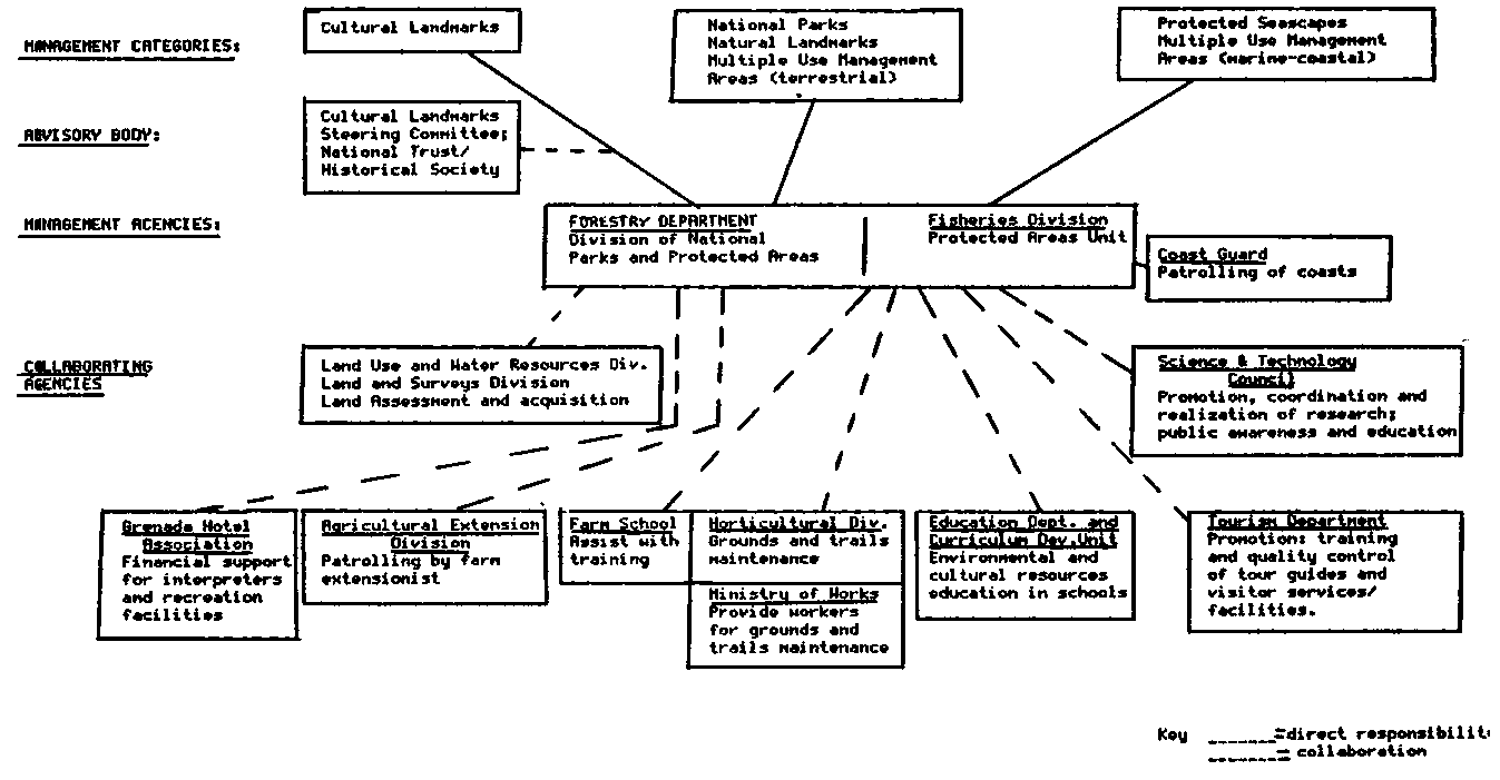
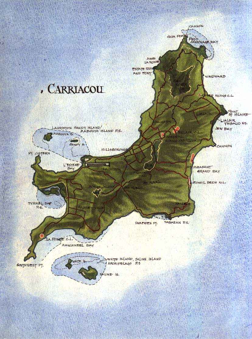