![]()
![]()
![]()
![]()
![]()
Mining in the Central Selva
Petroleum activity in the Central Selva
Factors limiting mining and drilling in the Central Selva
Interactions between the mining and petroleum industries and others
Guidelines for mining and petroleum planning in the Central Selva
Bibliography
![]()
The diverse metallic and non-metallic deposits of the Central Selva region are concentrated principally in the Department of Junin (See Map 1-1). Silver (Ag), zinc (Zn), lead (Pb), copper (Cu), and lesser amounts of gold are found here, as well as non-metallic mineral deposits of clay and calcareous minerals. Many of these minerals are worked by the San Vicente mine, the most typical and most important of the region. The operations of this mine will be examined below as the model for mining activity in the Central Selva.
The San Vicente mine is located at an altitude of 1,500 meters above sea level. Discovered in 1935, it was accessible by way of the Puntayacu river. Although various mineral deposits are exposed on both sides of the ravine cut by the Puntayacu, it was not until 1960, that The San Vicente Mining Company was formed, to prospect and exploit the zone; production began in 1970. The company has built a road network for its mining operations as well as laboratories, administrative offices, a medical center, and other buildings. To supply energy for these support services and for the mines themselves, the company uses eight internal combustion engines installed in a power station with a potential of 4,500 KW. A planned hydroelectric plant will increase this potential.
Initially, ten lead-zinc deposits and one zinc-lead-copper deposit were identified in a 16 km stretch. The most common sulfur mineral is sphalerite or zinc sulfide followed by galena or lead sulphide, which is found as fine crystals. Secondary minerals are Smithsonite, cerussite, anglesite, and calamine. Gangue minerals are represented by calcite and dolomite. Previous mineral chemical analysis determined the presence of zinc in the form of zinc sulfide (60.41 %) and zinc oxide (5.83%). Later chemical analysis of the mine's minerals found a proportion of 11.52 percent zinc, 1.11 percent lead, and 0.98 percent iron.
The reserve is tabular, in that the minerals are found in the surface layer of the rock. Reserves in 1980 were calculated to be 5,256,000 metric tons of proven and probable deposits (zinc and lead minerals). The purity of the minerals was determined to be 13.6 percent for zinc sulfide and 0.8 percent for lead sulfide. Considering that 429,947 metric tons of minerals were produced from the mine in 1980, the company should be able to maintain continued production for the next 12 years. Thus, probably 5,256,000 metric tons of proven and probable mineral reserves exist; additional exploration and development will probably turn up additional reserves.
The minerals are extracted, by conventional cut and fill methods, tunnels, shafts, and strip-mining. A series of short tunnels is dug between the surface and the mineral vein, where chimneys are opened to facilitate ventilation of the working areas. Infiltration of large amounts of water requires the use of pumps and special drainage systems.
Minerals are transported by carts from the mine interiors, using decauville lines. At the surface, the minerals are loaded onto trucks that carry them to the concentration plant. The concentrated material produced is then transported by dump-truck 320 km to the port of Callao, from which it is exported to the international market. The road travelled by the trucks goes through rough terrain and crosses two passes of more than 4,000 meters high.
The mineral concentrating process consists of crushing and pulverizing the ore, and separating the component through flotation and filtering. To improve the purity of the minerals, the company uses a concentration plant employing methods based on floatation and gravity that have a theoretical capacity of 2,500 MT per day. In 1980, 429,947 MT of minerals were processed, yielding 75,129 MT of concentrated lead and zinc. Chemical analysis of the lead concentrations found a lead proportion of 64.01 percent, a zinc proportion of 5.91 percent, and an iron proportion of 1.14 percent. Meanwhile, zinc concentrations were found to contain a lead proportion of 1.28 percent, a zinc proportion of 56.48 percent, and an iron proportion of 1.94 percent. After processing, somewhat more than 72 percent of the lead and 0.64 percent of the zinc in the lead concentrations are recovered, and from the zinc concentrations, 20.17 percent of the lead and 85.85 percent of the zinc.
Unused metal in the processing plant's washings is dumped into the Puntayacu river, turning the river bluish-white until it meets the Tulumayo river. Beyond the confluence with the Tarma river, the water appears normal, but some rather dramatic phenomena have been associated with mineral wastes in these rivers. Among them are skin problems affecting people using river water, the lack of agricultural and livestock activity along the banks, and the absence of fish up to the Chanchamayo river's confluence with the Paucartambo. Proposals to increase the 1,000 MT of minerals processed daily to 4000 MT would significantly increase the pollution of these rivers.
Gold and Manganese Deposits
Gold deposits in the region are alluvial, produced by the mechanical action of the streams and rivers draining the region. Ancient granites existing in the region are the sources of gold and heavy minerals. The principal deposits are along the margins of the Perene, Unine, Anapote, and Urubamba rivers. These precious metals are mined entirely by rustic methods.
Manganese deposits are also rich in iron. They usually are comprised of oxides, such as pyrolusite, man-ganite, hausmannite, and hematite and are found in the Quimiri and Huatshiroki areas in Chanchamayo, Pampa Tigre, Pampa Silva, and Sachavaca along the left bank of the Perene river. Although large, they have not yet been exploited. Other areas have been identified which, with 97.6 percent pyrolusite and 68 percent hematite, are also potentially rich in manganese and iron. Reliable data, however, do not exist that give an idea of volume and potential value.
Non-metallic Mineral Deposits
Calcareous clays and construction materials are widely distributed in the region in different lithological horizons. For example, the salt domes are part of the Jurassic Sarayaquillo formation while the various types of clays are fundamentally Quaternary deposits lying along river banks. In addition, calcareous minerals are scattered throughout the region as stratigraphic components of different geological formations. Finally, sand and gravel for construction materials are widely distributed as part of the Quaternary formations exposed along the region's drainage network.
Peru's gas and oil fields are believed to be primarily in the northeast and, in the Selva, lie north of the Marañon river and in the Central Ucayali. Because little is known about their potential yield, the Peruvian Government has divided the eastern region into sectors to be explored and eventually exploited.
The most significant hydrocarbon deposits in the Amazon basin, in terms of present production, are located in the northern forest region in the Department of Loreto while those of the Central Selva are the Maquia, Aguaytia, and Aguas Calientes deposits in the Department of Ucayali and in the Department of Huanuco.
Other indications of gas and petroleum have been detected in numerous forest localities. In the Central Selva they have been found along the Ucayali river, near Iquitos, and along the Marañon, and Santiago, Colorado and Alto Madre de Dios rivers.
Hydrocarbons are a mixture of thousands of different chemical compounds, varying from light gases to semi-solids, like asphalt, or solids like paraffin. Most of these hydrocarbons are found in solution in liquid hydrocarbons. Heavy petroleum that is not of the bituminous asphalt type has also been found in the Peruvian Amazonia, but because of its high molecular weight it does not have promising commercial potential. More exploration, however, has revealed the possible existence of commercially-exploitable petroleum in the region.
Exploration and Exploitation Activities
Exploration has been carried out throughout the Peruvian forest, especially in the area between the Urubamba, Tambo, and Ucayali rivers. Various methods have been used, the most important being seismic and exploratory wells.
Data from 1979 illustrate that the Amazon basin produced 67 percent of the nation's hydrocarbons. Four billion barrels of recoverable petroleum are estimated to exist in the country, 71.5 percent of which are believed to lie within the Peruvian Selva. Natural gas makes up 50 percent of the total reserves. Petroleum production from 1979 amounted to 70 million barrels, which means that, at the current rate, the reserves will last for approximately 57 years.
Petroleum activity in the region consists of exploration based in the Aguas Calientes camp, and petroleum extraction and transport in other parts of the region. The Aguas Calientes petroleum refinery has a 2,500 barrel per day capacity.
Transport of Petroleum and its Derivatives
The equipment used in hydrocarbon exploration and exploitation is primarily transported by planes, helicopters, boats of medium tonnage, and barges. The Ucayali river represents a portion of the most economic route for transporting products and materials between the Selva and the coast, which of course encourages settlement of the region (Faura Gaig, 1962). It also encourages the exploration of the region's natural resources because the Ucayali river crosses land where large deposits of bituminous substances have been found.
Petroleum from the northern Selva region of Peru is transported by a pipeline 856 km long that extends from Saramuro to Bayovar and from the branches of each production center. In addition, barges called chatas transport both unprocessed petroleum and its derivatives, principally diesel fuel.
Petroleum By-products
Normally, petroleum and brine are not entirely separated, and some petroleum, organic compounds, and dissolved gases are discarded along with the saline formation water. Concentrations of these substances vary; they usually constitute 0.1 -3.0 percent of the water volume. Considerable amounts of petroleum are also lost through spills, leaks, equipment and accessory washing and repair. Fumes from petroleum combustion, from the burning of petroleum and aromatic vapor gases in storage tanks and wells are discharged into the atmosphere. Generally, the gases burned during petroleum refining contain hydrogen, methane, ethylene, ethane, propylene, and propane. The impact these substances can have on humid tropical ecosystems is not known, but data from elsewhere suggest that dumping them into the region's streams could lead to serious consequences for the entire Amazon basin (Ossio, 1979).
Approximately 37 million hectares in the Amazon basin (8% of the total) cover wet, loose soils, which makes it very difficult to construct adequate access roads. Even if a road network can be built to provide access to different facilities and production locations, the work must be complemented by the use of helicopters, planes, and barges, since the roads deteriorate easily in heavy rains.
The climate in the humid tropics, meanwhile, is characterized by prolonged wet and dry seasons, which encourage erosion and landslides in areas where human activity has eliminated plant cover. Further, mechanized equipment deteriorates rapidly under such conditions. The human factor is important too. The scarcity of native workers with specialized skills means that people must be brought in from outside the region to work the mines and oil fields.
The mining sector plays an important role in the country's economy. Mining exports bring considerable capital into Peru and, therefore, accelerate development in the country. Mining creates jobs, and those working in mining are among the best paid workers in Peru.
Mining and mineral processing require the construction of physical and social infrastructures, such as road networks, schools, health services, and homes. At the same time, mining produces a multiplier effect in the other sectors. Agriculture must produce more food and the livestock sector more meat and milk to meet mining settlements' demands. More forest products are also used in the construction of houses, offices, and mines; and more firewood and livestock forage are consumed. Mining increases consumption of water resources for domestic use, metallurgical processing, energy generation, navigation, fire control, contaminant dilution, and sediment transport.
But mining practices can also have a detrimental effect on other activities, especially those affected by water. While the presence of small quantities of such elements as zinc, manganese, and copper can be beneficial in both soil and water, large amounts can be toxic. Concentrations of these elements in soil can increase because of atmospheric action and the dumping of mine tailings and waste water. This has, in fact, occurred in the vicinity of the San Vicente mine. The accumulation of such heavy metals as lead, zinc, copper, and mercury represents a problem for certain crops, especially lettuce and tomatoes, where concentrations become toxic.
The more soluble a component is, the more toxic it becomes. Zinc for example, is easily released from zinc sulfate in soil and carried away by surface and ground water. Thus, zinc ions are quite mobile and are found in a form between soluble cations and hydrolized elements. Zinc is an essential element in the biosphere and is fixed in the soil, partly by microorganisms. Small concentrations stimulate plant growth, but large quantities are toxic.
Manganese and copper also are essential elements found in all plants, in concentrations that vary with soil concentrations. Manganese affects plant growth and contributes to nitrate reduction in both higher plants and green algae. Like zinc, small amounts of both manganese and copper stimulate plant growth; large quantities are toxic.
The human resources of Peru are also profoundly affected by the mining industry. Mining and petroleum operations use labor brought in from outside the region. In general, Andean people work the mines, and coastal people the oil fields. How well these individuals adapt to forest conditions varies: some remain for years, others quickly return to their places of origin. Desertion rates are large because the workers are separated from their families and because the work is tedious. Moving from one area to another also involves certain health risks, notably the danger of encountering such diseases as dysentery, amoebiasis, and malaria. Furthermore, mine workers can become exposed to toxic gases, such as carbon monoxide, hydrogen sulfide, acetylene, methane, and carbon dioxide.
Petroleum activity, like mining, encourages the development of other sectors, since it contributes indispensable energy to them. In the vicinity of a working oil field, support industries develop, such as forestry to provide wood for homes and offices; agriculture to provide food, ornamental plants and medicines; and hunting to provide meat. Formerly, the company encouraged indiscriminate hunting to obtain sufficient meat, but this was found seriously to threaten the wildlife population, which was also reduced by explosions, and noise from helicopters and airplanes.
Extracting and desalinizing petroleum in the Selva region produces an average of two or three barrels of formation water (brine) for each barrel of processed crude (varying from almost 0 to 100 barrels or more per barrel of processed crude). The amount of saline water varies according to geology, locality, and age and type of well. Often the saline water is discharged into water courses. This is the least expensive dilution method (Ossio, 1979), but the river's dilution capacity, the brine salt content, how the river water is used, and the characteristics of its aquatic life all need to be considered because high salt levels can greatly damage fresh water ecosystems, especially during breeding seasons and when larvae and juvenile stages are present. One sudden and appreciable change in salinity can kill fish, but, given time, fish can either adapt to, or escape, saline water. The major problem is that sections of salt water act as barriers to migratory fish, preventing them from traveling up or downstream where they need to breed (Snedaker, 1977).
If the average chloride content in Amazonian rivers is 7 mg/l, it can be estimated that the volume of water required to dilute the salt to this concentration will be 323,960 m3 per day or 3.75 m3 for every 1,000 barrels processed. Table 13-1 compares the ion content of this brine with sea water. Brine also contains sulfates, magnesium carbonates, calcium carbonates, and lesser amounts of such substances as oils, organic compounds, and dissolved gases.
Table 13-1
ION CONTENT OF FORMATION WATER COMPARED WITH THAT OF SEA WATER
|
Ion |
Sea Water |
Brine |
|
Na+1 |
10,600 |
12,000 - 150,000 |
|
K+1 |
400 |
30 - 4,000 |
|
Ca+2 |
400 |
1,000 - 120,000 |
|
Mg+2 |
1,300 |
500 - 25,000 |
|
C1-1 |
19,000 |
10,000 - 250,000 |
|
Br-2 |
65 |
50 - 5,000 |
|
I-1 |
0.65 |
1 - 300 |
|
HCO3-1 |
- |
0 - 1,200 |
|
SO4-2 |
2,700 |
0 - 3,600 |
Source: Reid G., et al. (1974).
Saline wastes can also contaminate aquifers, which can be detrimental to agriculture. The petroleum in brine wastes will form a film over water surfaces that interferes with oxygen transfer essential to aquatic life and that damages the plumage of birds.
Water in the vicinity of Central Selva ports and embarkation points also becomes contaminated from the waste of boat crews and from spilled fuel. This is an especially serious problem during low water periods. Oil spill accidents are difficult to prevent, except by continual surveillance of storage facilities and pipelines. Accidents caused by rupture of the latter are of two types: minor spills that are hardly perceptible but which may have a cumulative effect, and major spills caused by total or partial pipeline ruptures. The economic impact of spills is considerable and includes cleanup costs and damage to fisheries, agriculture, recreation, and tourism.
Both the volatile compounds of low molecular weight and the dissolved gases in petroleum present risks of explosion, especially when combined with atmospheric oxygen. When gas concentrations are either low, as in well-ventilated areas, or much higher than explosive levels, risk exists and it can be very dangerous to work under such conditions.
The workers themselves can have an impact on the surrounding areas unforeseen by the company's planners. Unplanned and disorganized settlements tend to develop in the vicinity of petroleum camps. Often the community is made up of relatives of the petroleum workers, who were not able to be accommodated by the petroleum company's facilities.
Regulations governing the use of Amazonia's national parks are frequently ignored by mining interests. For example, hunting, fishing, and petroleum activities have been carried out in the Pacaya-Samiria National Reserve for the last 10 years without consideration of reserve regulations; "gold fever" in Madre de Dios Department caused a major immigration of miners, merchants, and others into the region and into the department's Manu National Park, as well.
A large part of the Pacaya-Samiria Reserve, where petroleum activity has been extensive, is plagued with pollution of synthetic materials (plastics and techno-port), while the riverbank fauna - capybara, monkeys, and birds - are made increasingly nervous by the noise created by helicopters and boats. In addition, the nesting beaches of paiche, turtles, taricayas, and cupisos are eroded by boat wakes.
To eliminate the dumping of noxious wastes, a technique has been proposed for U.S. mines in which concrete and asphalt are used to hermetically contain the pollutants. Remaining material can be left exposed or covered with soil, depending on the material and the way the soil will be used in the future. Figure 13-1 schematically illustrates this technique.
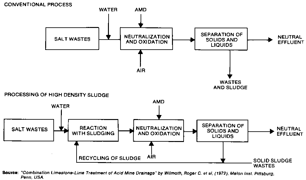
The wastes generated from desalinizing petroleum are usually disposed of through direct discharge, evaporation lagoons, and subterranean injection. Figures 13-2 and 13-3 illustrate how to control such contamination.
The Water Law prohibits pollution of water resources, and it is the responsibility of the mining and petroleum companies to comply. One suggested preventive measure is to prohibit the construction of facilities that do not use effective filters, anti-pollutant devices, and purifiers and to inspect the pollution control equipment of all new mining and petroleum enterprises. Drainage and other hydraulic works also need to be inspected to ensure that water containing pollutants does not enter natural drainage systems (Table 13-2).
Mining and petroleum companies can treat, store, and eliminate harmful wastes to minimize conflicts with other activities. One report recently published by the Committee on the Challenges of Modern Society, listed the following seven options, in order of priority, for effective management of dangerous wastes.
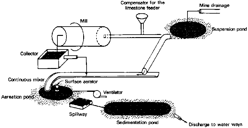
Figure 13-1 - REDUCTION OF SURFACE WATER INFILTRATION
Figure 13-2 - ALKALINE NEUTRALIZATION
FIGURE 13-3 - DIAGRAM OF THE NEUTRALIZATION PROCESS UTILIZING LIME
1. Reduction of waste quantities at the source; for example, utilization of wastes in the hydraulic support at the San Vicente mine, or injection of salt water into petroleum wells, or treatment of settlement wastes.2. Separation and concentration: the separation of liquids from solids to facilitate treatment.
3. Changes in dangerous wastes: research can be conducted into finding less toxic material to be used in recovering minerals.
4. Recovering materials: for instance, wastes can be used directly to provide energy, or they can be transformed into useful products.
5. Destruction through incineration and energy recuperation.
6. Detoxification and neutralization.
7. Reduction of volume.
Each option can be effectively applied alone or combined with others in order to retain mining and drilling as principal economic activities in the nation while lessening the damage to the natural resources and ecosystems on which they depend.
Table 13-2
WATER QUALITY STANDARDS FOR FISHING AND IRRIGATION
|
Parameter |
Peru |
OMS |
|
Suspended Solids |
Absent |
80 |
|
Oils, Fats |
Absent |
- |
|
Phenols |
0.001-0.002 |
0.001-0.002 |
|
Lead |
.10 |
0.05-0.10 |
|
Fluoride |
1.5 - 2.00 |
3.4 |
|
Arsenic |
0.20 |
0.05 |
|
Selenium |
0.05 |
- |
|
Chromium+6 |
0.05 |
0.05 |
|
Cyanide |
0.01 |
0,05 |
|
Silver |
0.05 |
N/R |
|
Nitrates |
100 |
45 |
|
Chloride |
N/R |
200-600 |
|
Manganese |
0.1 - 0.5 |
0.50-0.50 |
|
Copper |
1.0-1.5 |
0.05-1,50 |
|
Zinc |
5.0- 15.0 |
5.0-15.0 |
|
Sulfates |
400 |
200-400 |
|
Magnesium |
150 |
30-150 |
|
Iron |
0.30-1.0 |
0.1-1.0 |
Source: MAA, 1969.
Davidow, M. 1974, La protección de la naturaleza. Mosco.
Faura Gaig, G. 1962. Los ríos de la Amazonía peruana. Lima, Peru.
Grim, E.G. and R.D. Hill, 1972. Surface Mining Methods and Techniques. Mine Drainage Pollution Control Activities for National Environmental Research Center, Ohio.
MAA. 1969. Ley General de Aguas. Decreto Ley 17752. MAG. Peru
Mihok, E.A. 1968. The Limestone Neutralization Process. USAI Bureau of Mines. Information Circular Report 7191.
Ossio, E.A. 1979. Análisis ambiental de la explotación de petróleo en la Amazonía peruana. V Congreso Nacional de Ingeniería Sanitaria y Ambiental, Lima, Perú. 12-16 Nov.
Reid G., L. Streebin and L. Canter. 1974. Brine Disposal Treatment Practices Relating to the Oil Production Industry. Washington, D.C. Environmental Protection Agency (EPA) - 660/2-74-037.
Snedaker, S.C. 1977. Report to the Organization of American States covering the Mission to Peru. OAS, Washington, D.C.
![]()
![]()
![]()
![]()