![]()
![]()
![]()
![]()
![]()
Case Study 1: Comparative Analysis of the Florida Everglades and the South American Pantanal
Case Study 2: Infrastructure for Water Supply and Sanitation in the Hemisphere
![]()
Presented by
Jeffry S. Wade, John C. Tucker, Richard G. Hamann
Center for Governmental Responsibility
University of Florida College of Law
Gainesville, Florida
at the
Interamerican Dialogue on Water Management
Miami, Florida, USA
October 27-30, 1993
I. OVERVIEW
A. Ecosystem Structure and Impacts
Though the Pantanal and Everglades share important physical and biological characteristics, there are significant differences in the structure and ecological functioning of the two systems. Both are large, internationally significant freshwater wetland systems, though the Pantanal watershed is several times larger than that of the Everglades. Both systems are dependent on larger watersheds. The Pantanal receives direct rainfall and water from many riverine systems and is drained by a major river. The Everglades, in addition to rainfall, is dependent on a single river and lake system which historically supplied sheetflow to the system. It drained, in turn, to a dependent estuary. The differences in elevation and degree of natural sedimentation rates from surrounding uplands are much greater in the case of the Pantanal. The Everglades developed as an oligotrophic ecosystem, more vulnerable to slight increases in nutrients. Variability in the sub-basins of the Pantanal make generalizations difficult concerning that system. It appears that the Pantanal evolved with higher nutrient levels associated with sedimentation processes.
Soils in the upper basin of the Pantanal appear to be more susceptible to erosion than those in the upper basin of the Everglades. Generally, soils in the lower basin of the Pantanal are less organic than those in the Everglades lower drainage areas. Yearly and wet season rainfall totals appear to be approximately equivalent in each system. Both ecosystems depend on water regimes with yearly wet and dry cycles, however the Pantanal experiences greater differences in water levels between dry and wet seasons. Historically, the relative abundance of wildlife in the two systems appears to have been roughly equivalent, though diversity may have been greater in the Pantanal. Currently, the Pantanal supports much more diversity and abundance of wildlife.
Some of the more significant impacts to the water regime in both Pantanal and Everglades ecosystems involve planned or existing large scale water development projects. Since the 1880s, a government-subsidized process of dredging, draining and channelization within the Everglades watershed has profoundly altered the quantity, quality, timing, rate and distribution of water flows to that ecosystem. Impacts on ecosystem functioning have included the significant loss or degradation of native plant communities, the loss or destruction of wildlife habitat, including that of threatened and endangered species and estuarine-dependent fish, and the loss of hydrostatic pressure in fresh water aquifers.
For many years, the natural resources of the Upper Paraguay Basin have played an important role in local economies. Large scale water development projects have not been attempted in the Basin, due in large part to its remoteness and lack of national economic importance. However, the planned Paraguay-Paraná Waterway (Hidrovia), being promoted by international development interests, has the potential to cause significant disruption of ecosystems in the Pantanal. As currently promoted, the first phase of the project would involve the dredging of a large percentage of the Paraguay River below Corumbá, with possible negative impacts on wetlands ecosystems in the Pantanal. The second phase of the project appears to include major water control structures, dredging and channelization above Corumbá, with potentially significant negative effects on ecosystem function and extensive secondary impacts.
There are very large soybean, sugar, rice and corn plantations in the highlands (planaltos) of the Pantanal watershed. Deforestation of the region, including loss of gallery forests and other vegetation along rivers, as well as poor water management practices on farms, appear to be contributing to extensive sedimentation of rivers in the Pantanal plain. The intensive agricultural techniques used in the relatively poor upland soils include the application of large amounts of agrochemical pesticides, fungicides and fertilizers, a significant percentage of which may be entering the Pantanal lowlands, primarily during periods of higher rainfall and flooding. Cattle ranching on the plains (planície) is dispersed, however impacts to vegetation from burning and grazing have been noted and the introduction of non-native grasses with low survivability leads to sedimentation.
Agricultural development in the Everglades is concentrated in areas just south of Lake Okeechobee, but is also present in several areas near Everglades National Park. Extensive diking and drainage were necessary to expose the muck soils which support many thousands of hectares of sugar cane just south of Lake Okeechobee. Rock plowing, intensive use of agrochemicals, and massive groundwater withdrawals are necessary to support winter vegetable and citrus production in areas farther south near Everglades National Park. In addition, a long history of dairy farming in regions around the Kissimmee River contributed to the eutrophication of Lake Okeechobee. The cumulative negative impacts on the hydrologic regime and on water quality in the Kissimmee/Lake Okeechobee/Everglades (KLOE) ecosystem have profoundly altered the functioning of the Everglades.
Mining and industrial operations represent important manipulations of the water regime of both Everglades and Pantanal ecosystems. The extent of various extractive industries and specific impacts of gold mining in the Pantanal watershed appear to have greater total negative consequences than those of extractive industries in the Everglades.
At present the consequences of urban development are more significant in the Everglades than in the Pantanal, with population pressures still very high. However, urban development pressure is increasing within the Pantanal watershed. A very low percentage of households in the region receive advanced sewage treatment, and control over other associated urban effluents is inconsistent. Continuing population influx will require infrastructure development, and careful planning and regulatory response.
Current conditions in the Pantanal and historic conditions in the Everglades represent what might seem to be virtually unlimited opportunities for exploitation of wildlife. In the case of the Everglades, fish, alligators and deer were taken by subsistence and commercial hunters beginning early in the history of human occupation of the area, at generally sustainable levels. However, the killing of tremendous numbers of wading birds from the 1870s to 1930s to satisfy the fashion industry's need for plumes was unprecedented. Millions of birds were taken before public opinion, changing styles and new legislation ended the slaughter. Several rookeries were completely extirpated and many have never recovered. Though by the 1960s, the alligator had been placed on the endangered species list for protective purposes, by the 1980s, populations had increased significantly. The controlled hunting program for alligators now in effect is a measure of the current success of the species. Other species have experienced serious declines in population for reasons only partially related to hunting, and authorities have been generally unsuccessful in helping those species recover.
Biological, social and economic conditions in the Pantanal roughly approximate those of the Everglades much earlier in its history. The sheer numbers of fish and other wildlife offer seemingly limitless opportunities for commercial and recreational harvest. Historically, the Pantanal ecosystem was used for subsistence level hunting and fishing by relatively small populations of indigenous peoples, whose activities had little impact on ecosystem functions. Currently, commercial overfishing has become a serious problem, essentially mining fish from the system at unsustainable rates. Though illegal, the taking of caiman for hides and many species of birds for the pet trade also continues to reduce populations.
B. Legal and Policy Response
The regulatory and enforcement tools available to agencies with jurisdiction over the Pantanal and Everglades share some similarities and differences. Though the Brazilian Constitution includes clearly articulated environmental rights, and specifies additional protection for the Pantanal as part of the “national patrimony,” the federal and state laws intended to implement those protections do not adequately address all potential threats and are inconsistently applied. The establishment of Everglades National Park placed protective boundaries around the lowest sections of the Everglades, but other related parts of the watershed have received very little specific protection. Regulatory exemptions, lack of coordination between agencies, and gaps in legislation have allowed continued degradation of the KLOE ecosystem. Only recently have issues concerning water resources for the Park and other sections of the Everglades been given the priority that is necessary in order to restore and maintain ecological functions.
There are very large differences in the physical, technical and monetary resources available to regulatory, research and planning institutions in the two ecosystems. Federal, state and regional agencies in Florida have access to sophisticated technical equipment, with relatively good research, monitoring and enforcement capabilities. The Brazilian economic crisis, combined with a general ambivalence toward environmental regulation, has resulted in a lack of institutional capability for most institutions in the Pantanal. In the past, a centralized approach to governmental regulation gave more authority and resources to federal institutions, while state agencies suffered. Recent changes in institutional emphasis, combined with a growing cultural appreciation of the need for environmentally sustainable development, have translated into increased resources for state level institutional development and greater regulatory authority. However, there is still a crucial need for funding to support adequate research, planning, permitting, monitoring and enforcement for environmental purposes in Brazil.
The problem of political will affects agencies in both ecosystems. For many years scientific information on the Everglades has documented a system in environmental decline, yet despite debate, increased regulatory authority and institutional capabilities, the degradation continued. It has taken near crisis conditions, and a federal lawsuit, to force responsible parties toward an effective response. A low level of perceived environmental threat to the Pantanal, combined with politically powerful development interests and a national drive for economic growth have allowed for ill-advised agricultural, industrial and mining operations to be permitted in the Pantanal watershed, particularly in the highlands.
II. ECOSYSTEM DESCRIPTIONS
A. Pantanal
The Pantanal, or “swampland” in Portuguese, is an immense alluvial plain within the Upper Paraguay River Basin in western Brazil, eastern Bolivia, and northeastern Paraguay. (Fig. 1) The Upper Paraguay Basin, including all associated upland areas, contains 496,000 square kilometers (191,500 square miles), of which approximately 80%, or 396,800 square kilometers (153,200 square miles) lie within Brazil, primarily in the states of Mato Grosso and Mato Grosso do Sul (SEMA, 1993). The Pantanal itself includes only the 140,000 square kilometers (54,000 square miles) of alluvial plain or planície, but a complete understanding of the ecology and management of the Pantanal requires consideration of the associated highlands, or planaltos. Altitudes range from 80-150 m (260-490 ft.) on the plains, to over 250 m (820 ft.) on the planaltos (Ferreira, 1992), with some isolated peaks over 1000 m (3250 ft.) southeast of Corumbá (Scott and Carbonell, 1986).
Fig. 1. Location of Pantanal Watershed Within Brazil
Though the Pantanal is one of the largest wetlands in the world, it is more properly characterized as a related series of river floodplains. Principal rivers in the basin include the Paraguay, Miranda, Cuiabá, São Lourenço, Negro, Taquarí, and Aquidauana, all originating in the planaltos. (Fig. 2) The Paraguay River is the major north-south watercourse in the Pantanal, extending 2800 kilometers (1735 mi.) from its source in the northern highlands of Mato Grosso, Brazil to Corrientes, Argentina, where it joins the Paraná River. Situated at the interface of three major South American ecosystems, the Pantanal includes characteristics of Amazon rainforest, cerrado scrub forests of central Brazil, and the chaco vegetation of nearby Bolivia and Argentina. Within the watershed, ten different ecological subregions have been identified (Adámoli, 1992). The area is dominated by a matrix of seasonally-flooded savanna, streams, rivers, ponds, lakes and marshes. Principal vegetation consists of scrub forest and savanna characterized by native grasslands interspersed with gallery forest, humid semi-deciduous forest and wetland vegetation.
Fig. 2. Map of the Pantanal Region
Source: Bucher et al., 1993.Total yearly rainfall in the basin is approximately 1100-1500 mm (43-59 in.), 80% of which falls from November to March (Scott and Carbonell, 1986). Beginning in November, up to 70% of the 450 kilometer long Pantanal basin is slowly inundated, turning it into a vast, shallow inland sea, interspersed with higher areas which do not flood. The lowland plain slopes from north to south at about two centimeters per kilometer, allowing only very slow movement of flood waters. Depending on local elevation, flooding lasts from three to nine months. Maximum water levels in the northernmost reaches of the Paraguay River normally occur during January and February, and in the southern areas during May and June. Within several months after peak floods, evaporation, evapotranspiration, absorption and outflow transform the area into a huge savanna, including rivers and tributaries, open grasslands, isolated pockets of cerrado forest vegetation, and many shallow waterbodies with large numbers of trapped fish, attracting wading birds and other wildlife.
The Pantanal supports a great diversity and abundance of wildlife. Over 650 species of birds have been identified. The region is one of the world's largest breeding grounds for wading birds, an important migratory bird stopover point, and probably the most important area in South America for wetland birds (Mittermeier et al., 1990). Over 260 species of fish have been identified, with about 10-12 species caught for commercial purposes. Large numbers of other species of wildlife exist in the region, encompassing approximately 80 mammal species, 50 species of reptiles and over 1.000 species of butterflies. Some of the most unique animals in the world inhabit the Pantanal, including the giant anteater (Myrmecophaga tridactyla), giant river otter (Pteronura brasiliensis), maned wolf (Chrysocyon brachyurus), capybara (Hydrochoerus hydrochaeris), tapir (Tapirus terrestris), jaguar (Panthera onca palustris), puma (Felis concolor), caiman or jacaré (Caiman crocodylus yacare), swamp deer (Blastocerus dichotomus), howler monkey (Alouatta caraya), blue hyacinth macaw (Anodorhynchus hyacinthinus) and the jabirú stork (Jabiru mycteria) (Mittermeier et al., 1990).
B. Everglades
The Everglades is a system of shallow sawgrass marshes, tree islands, wet prairies and aquatic sloughs that historically covered most of southeastern Florida (Davis, 1943). (Fig. 3) Formation of the Everglades began over 5000 years ago as organic matter and sedimentary deposits accumulated in a limestone depression which underlies much of the southern tip of Florida (SWIM, 1992a; Parker and Hoy, 1943). By the end of the 19th century wetlands covered about 10,000 square kilometers (3,900 square miles). The original Everglades extended from the south shore of Lake Okeechobee to the mangrove estuaries of Florida Bay, and were over 64 km (40 mi.) wide and 160 km (100 mi.) long (SWIM, 1992a). The Everglades is an integral part of the larger Kissimmee/Lake Okeechobee/Everglades system, which covers much of south and central Florida below the City of Orlando. They are bordered on the east by the Atlantic coastal ridge and on the west by the Immokalee rise (SWIM, 1992a; Parker and Hoy, 1943).
Fig. 3. Map of Everglades Watershed (Historic)
Source: Light and Dineen, in press.Historically, water from the Kissimmee river basin flowed slowly south toward Lake Okeechobee, overflowed the Lake's southern rim, and moved as a shallow sheetflow through the Everglades and into Florida Bay and adjacent coastal waters. Natural drainage of the Everglades occurred to the east through a series of breaches in the coastal ridge, to the south through several sloughs, and to the west through the Big Cypress Basin. In addition, as a result of direct connections between ground water and surface waters in portions of the area, groundwater seeped through the porus limestone aquifer and discharged as freshwater springs into coastal waters (SWIM, 1992a; Parker et al., 1955; Harlem, 1979). Rainfall, evapotranspiration, and outflows to the sea resulted in a constant exchange of water between the atmosphere, salt and fresh surface waters, and the aquifer (SWIM, 1992a; Davis, 1943; Parker et al., 1955; Wagner and Rosendahl, 1987). The volume of water which flowed through the historic Everglades system is greater than what occurs today (SWIM, 1992a), due to drainage and flood control discharges to the sea.
Climate and weather patterns are closely tied to the hydrology of the region. Average yearly rainfall is 1350 mm (53 in.), about 75% of which occurs during the wet season (May to October) (SWIM, 1992a; Shih, 1983). Rainfall during the wet season is typically in the form of convective showers which occur almost daily, while winter rainfall is typically associated with winter frontal storms. Rainfall over the region is characterized by considerable variability between seasonal and annual amount, and in areal distribution (SWIM, 1992a).
Elevations in the Everglades region are generally less than 6 m (20 ft.) above sea level. The ground surface slopes gently from north to south with an average gradient of 2.8 cm/km (.15 ft./mi.) (SWIM. 1992a; Parker et al., 1955). The predominant soils of the Everglades region are organic histasols (muck or peat), overlying limestone formations. The muck soils have accumulated in a layer of up to 5.5 m (18 ft.) thick in the northern Everglades (SWIM, 1992a; Stephens and Johnson, 1951) where limestone elevations are lowest, to about one meter (3 ft.) or less in the southern Everglades. Another dominant soil type, calcitic mud, occurs in shallow peripheral marshes of the southern Everglades which undergo shorter periods of inundation than where muck soils occur.
The interaction of climate, geology, and topography with surface water, which makes up the hydrologic cycle of the region, shaped the biological system which developed in the Everglades. Everglades ecosystems evolved under conditions in which water availability varied from season to season and from year to year. The systems depend on the annual pattern of wet summer and dry winter seasons, as well as on a certain degree of variation in rainfall and the amount of surface water, for their continued existence (SWIM, 1992a). Accordingly, the variability and diversity of the biological systems are related to the natural variability of the hydrologic system (SWIM, 1992a).
The original Everglades comprised about one million hectares (2.5 million acres) of freshwater marsh (SWIM, 1992a). Major Everglades plant communities include the periphyton (algae) community, the sawgrass community, the wet prairie, aquatic sloughs, bayheads or tree islands, willow heads, tropical hardwood hammocks, cypress forest, and coastal mangrove forest communities (SWIM, 1992a). The Everglades were historically bordered by seasonal or short hydroperiod wetlands and upland pine habitat (Davis, 1943).
The major habitat types found in the Everglades region include upland forests, wetland forests, marshes, wet prairies, open water ponds and creeks, and mangrove forest (SWIM, 1992a). Most of the animals utilize a variety of habitat types, in response to the drying out and flooding of various areas during the annual water cycle.
Historically, wildlife species diversity in the Everglades was relatively poor, particularly compared to the species rich Pantanal, though the ecosystem did support tremendous numbers of birds and alligators. The majority of animal species, including the land mammals, and most of the breeding birds, reptiles and amphibians, appear to have colonized from the temperate southeastern coastal plain (SWIM, 1992a; Layne, 1984; Gunderson and Loftus, in press). The wetland and wading birds are dispersed throughout the West Indies (SWIM, 1992a; Robertson and Kushlan, 1984). Animals endemic to the region include the Everglades mink, the rice rat, the hispid cotton rat, the round-tailed muskrat, and the Cape Sable seaside sparrow (SWIM, 1992a).
The relatively low species diversity found in the Everglades is probably due to a variety of factors, including the young geologic age of the region, the lack of diversity in aquatic and terrestrial habitats, and its peninsular location (SWIM, 1992a). At least 44 species of amphibians and reptiles (SWIM, 1992a; Duellman and Schwartz, 1958), almost 400 species of birds (SWIM, 1992a; Robertson and Kushlan), and about 30 species of mammals (SWIM, 1992a; Schwartz, 1952; Layne, 1984) occur within the Everglades. About 60% of the bird species are wintering and migrant birds.
III. HUMAN USE AND DEVELOPMENT
The quality and quantity of water are key variables in the functioning of both the Pantanal and Everglades ecosystems. Both systems are highly dependent on the duration, distribution and timing of water flows. These characteristics, in turn, are subject to human interference through large scale water development, flood control and navigation improvement projects. The Everglades has been most significantly altered by such projects, but plans under consideration for development in the Pantanal may significantly alter that system as well.
Water quality has also been affected by human activities in both the Pantanal and Everglades. In both cases, there are significant threats from agricultural development in the watershed. Both systems are also contaminated by mercury. In the Pantanal the source is gold mining in the watershed. The source of mercury contamination of the Everglades is not yet known, but it has probably been transported by atmospheric processes. In addition, the Pantanal also receives point source discharges from industrial and urban sources.
Other key variables are the degree to which land cover has been altered through clearing, grazing or other activities and direct utilization of fish and wildlife. Much of the Everglades has been drained and convened to urban and intensive agricultural uses. The remaining Everglades is largely protected from such alteration. It is highly susceptible, however, to an ongoing invasion of non-native plant species, principally melaleuca (Melaleuca quinquenervia), Brazilian pepper (Schinus terebinthifolius) and Australian pine (Casuarina equisetifolia). Land cover in the Pantanal plains remains largely intact, though it is subject to extensive grazing, limited logging and some clearing for pasture improvement. Many parts of the Pantanal highlands have been extensively cleared for agriculture and pasture.
The protected status of most of the remaining Everglades, and its relative lack of human habitation, means that direct utilization of fish and wildlife have relatively insignificant impacts on their populations. The commercial harvest of fish and the illegal harvest of several species of wildlife may have significant impacts in the Pantanal.
A. Large-scale water development projects
1. Pantanal
The Pantanal ecosystem is based on an annual cycle of flooding and drought, including a multi-year pattern involving occasional greater fluctuations, or pulses, in the cycle. The Pantanal plains absorb and moderate the flow of water through the Paraguay River (Bucher et al., 1993). Though wildlife in the region is adapted to the natural cycle of flooding and drought, extremely high water conditions can cause loss of caiman nests, and restriction of habitat for capybara and many other non-aquatic wild and domestic species (Ferreira et al., 1992). Conversely, extreme drought conditions can severely stress both domestic animals and wildlife, and greatly restrict aquatic and wetland habitats.
A potentially significant interference with natural hydroperiods and flow patterns is the proposed Paraguay-Paraná Waterway (Hidrovia), a massive navigation project which would increase transportation efficiencies for several products of the Pantanal and surrounding areas. The primary impetus for the Hidrovia is an agreement among Brazil, Bolivia, Uruguay, Paraguay and Argentina to create a regional common market, known as MERCOSUL or MERCOSUR (Andersen, 1992).
Though the proposal is at an early stage, there are concerns that the project could have serious negative environmental impacts (Bucher et al., 1993; Ferreira et al., 1992). As presently configured, the Hidrovia would include two modules or phases. The first is a short-term, fairly restricted project consisting primarily of channel dredging from Santa Fé, Argentina to Corumbá, Brazil, as well as signposting from Corumbá to Nueva Palmira, Uruguay. Currently, the Inter-American Development Bank is funding a US$2 million study of potential environmental impacts of this phase, and close to US$8 million for engineering and economic pre-feasibility studies. The second phase would include dredging, course changes, channel straightening and stabilization, and construction of water control structures for navigational purposes between Cáceres, Brazil and Nueva Palmira, Uruguay, including additional work within the Pantanal (Bucher et al., 1993).
There are many direct and indirect impacts associated with the proposed works. Direct impacts from the first phase of the project would include dredging and channel maintenance, deposit of dredged material and the physical effects of increased barge and ship traffic on the river banks. Dredging destroys habitat and organisms in the affected area, changes the composition of bottom material and increases water velocity in the dredged channel (Bucher et al., 1993; Allen and Hardey, 1980; Rasmussen and Harber, 1981). Changes in stream velocity are associated with water quality impacts caused by increased turbidity and suspended sediments. Depending on where dredged material is deposited, there may be direct destruction of habitat for nesting fish or birds, spawning fish or other vertebrates (Bucher et al., 1993; Allen and Hardey, 1980; Rasmussen and Harber, 1981). The single most potentially damaging impact of the Hidrovia project would be the loss of the Pantanal's function in moderating and absorbing flood waters on the Paraguay River (Bucher et al., 1993).
The hydrological regime of upper reaches of rivers can be significantly altered by construction and maintenance of downstream navigation channels, if channel capacity is increased at points of natural geomorphological constriction, increasing rates of drainage. In addition, channelization can exacerbate downstream flooding by increasing peak flows in a river (Bucher et al., 1993). Channel dredging and straightening can also affect the hydrological regime controlling wetland ecology. Though there is relatively little technical understanding of the hydrologic functioning of the Paraguay Basin, researchers have estimated that if the river channel were deepened by approximately 0.5-1.0 meter in that area, the extent of important floodplain wetlands might be significantly reduced in upriver regions which normally flood to less than one meter (Ferreira et al., 1992).
Of particular concern are the long-term impacts that alteration to the hydrology could have on the flora and fauna of the Pantanal. As evidenced in the Everglades, changes in water regimes can have many substantial and unanticipated adverse effects, including disruption of nesting and feeding behavior of wildlife, and changes in species composition and diversity. Ultimately, depending on the scale of the alterations, water management projects can substantially change the character and integrity of freshwater ecosystems.
In addition to impacts from dredging and channel straightening, channel maintenance structures, water control structures and the harbors and terminals that would be included in construction of the Hidrovia, there is also concern that a related increase in agricultural, industrial and urban activity (Bucher et al., 1993; Internave, 1992) would cause corresponding increases in pollution from agrochemicals, and industrial and urban wastes (Bucher et al., 1993).
2. Everglades
There has been extensive manipulation of water flows in the Kissimmee River-Lake Okeechobee-Everglades system by federal and state government, beginning in the late 1880s. Efforts to drain the region for agricultural purposes began as early as 1907, with the creation of the Everglades Drainage District. Early efforts included construction of a canal between Lake Okeechobee and the Caloosahatchee River, channelization of the Caloosahatchee and Miami Rivers, and digging of other canals through the Atlantic Coastal Ridge to facilitate drainage from Lake Okeechobee to the Atlantic Ocean. By 1927, six major drainage canals and many smaller canals had been built, including 440 miles of levees and 16 locks and dams.
Between 1926 and 1947, hurricanes and long periods of drought caused extreme fluctuations of water levels in the region. While flood control had been the primary concern in the past, the region was now faced with the additional problem of maintaining an adequate water supply for the rapidly increasing populations on the lower east coast of Florida. In response, Congress initiated the Central and Southern Florida Flood Control Project in 1947 to provide urban and agricultural flood control and to ensure adequate water supply. The U.S. Army Corps of Engineers constructed a series of canals, levees, water retention areas, pump stations, and water control structures that extended throughout the entire length of the Everglades system. Today, this system includes over 2250 km (1,400 mi.) of canals, levees, water retention areas, pump stations, and water control structures in and around Lake Okeechobee and the Everglades. (Fig. 4)
Fig. 4. South Florida Water Management District (Drainage Canals and Surface Water Control System)
Source: Light and Dineen, in press.Early drainage efforts had the desired effect, opening up much of the area to farming and other uses. However, construction of early canals also resulted in a number of readily observed problems. Water levels in Lake Okeechobee dropped from 6.7 to 4.6 meters (21.9 to 15 feet) above mean sea level between 1889 and 1927 (SWIM, 1992a). Water tables were lowered 1.5 to 1.8 meters (5 to 6 feet) below 1900 levels, thereby stressing natural wetland systems (SWIM, 1992a). Other adverse impacts to the system included muck soil loss of up to 1.8 meters (6 feet) in depth, loss of water storage capacity (Davis, 1946), and uncontrolled fires.
During the 1960s, much of the Kissimmee River, the northernmost component of the KLOE system, was channelized. Channelization efforts considerably altered the hydrology of the Lower Kissimmee Basin and led to the loss of about 16,200 to 20,235 hectares (40,000 to 50,000 acres) of wetlands (SWIM, 1993). Drainage of the historic floodplain led to increased agricultural development (improved pasture and intensive dairy operations) along the river. Channelization and destruction of floodplain marshes reduced the natural phosphorus removal capabilities of the river. The reduced phosphorus removal capability of the river coupled with runoff from agricultural operations led to increased phosphorus loadings in Lake Okeechobee (SWIM, 1993; Lamonds, 1975; Federico, 1982). Channelization also altered the rate and amount of water which enters Lake Okeechobee.
Efforts to drain the Everglades and to control flooding substantially altered the quantity, timing, distribution, and rate of water flows in the natural system. These changes in the historic hydrologic regime of the Everglades, in combination with other factors, have resulted in substantial impacts to the biological components of the system, including significant loss or degradation of native plant communities and loss or destruction of habitats of threatened and endangered plants and animals. Almost one half of the original 1,619,000 hectares (4,000,000 acres) of wetlands in the Everglades have been lost to agriculture and urban development. Various species of wildlife have been adversely impacted by changes in natural flooding regimes. These changes have also contributed to problems associated with the quantity, timing and discharge of freshwater into the estuaries of Florida Bay, Manatee Bay, and Barnes Sound. Such changes have significantly reduced the ability of these estuaries to support fisheries at formerly highly productive levels.
B. Agricultural development
In the past twenty years, primarily in response to national economic goals, use of the planaltos surrounding the Pantanal plain has shifted dramatically toward intensive agriculture and cattle production. Though the low quality and erosive tendencies of soils in the region was known at the time, the drive to develop superseded concerns over the ecological functioning of downstream lowlands. The placement of intensive agricultural operations in the highlands continues to threaten the Pantanal planície. Use of massive amounts of agrochemicals and poorly planned water management systems have chronic long-term negative effects on the biology and hydrology of the area. Though public attention has recently begun to focus on the impacts of large scale agricultural operations, given the continuing economic crisis in Brazil and traditionally low concern for environmental values (Guimarães, 1991), it may be difficult to achieve meaningful change in agricultural practices in the near future.
The program is not dissimilar to that pursued by federal and state authorities in Florida at the turn of the century, when they officially supported and subsidized a program of drainage and agricultural development in the Everglades region south of Lake Okeechobee. The resulting impacts on water quality, quantity, timing and distribution to the rest of the Everglades have severely affected the functioning of the ecosystem.
1. Pantanal
Most of the rivers and tributaries draining into the Pantanal have their sources in the surrounding highland plateaus, or planaltos. In several regions, the planaltos are patchworked with extensive agricultural operations, most dedicated to soybean production, but including sugar cane, rice and corn. In the planaltos surrounding the Pantanal to the north and west, approximately 75% of the original cerrado forests and savannas have been converted to agriculture or pasture. Soils are relatively poor, yet intensive farming in these areas has been growing since the 1970s. To maintain soil fertility and combat crop pests, farmers have increasingly relied on extensive use of a wide variety of agrochemicals, including fungicides, pesticides, and fertilizers. Deforestation, including the clearcutting of vegetation bordering rivers, and poor water management practices have resulted in extensive agrochemical runoff, soil erosion and river sedimentation.
During the rainy season, extensive flooding, and some sedimentation and movement of river channels is considered normal in several rivers entering the Pantanal. However, there is growing concern that increased sediment load as a result of deforestation and farming on the surrounding uplands may be worsening flood conditions in the lowlands during the rainy season. In Mato Grosso, approximately 14 metric tons of soil per hectare per year is being eroded from farms on the planaltos (Teixeira, 1993). Higher sediment deposition in a river bed causes a decrease in flood storage capacity and a corresponding increase in flooding and channel movement (Bucher et al., 1993; Alho et al., 1988; Ferreira et al., 1992). The problem appears to be particularly severe on the Taquarí River, one of the major tributaries of the Paraguay River. Approximately 1,800,000 hectares (4,446,000 acres) of the upper Taquarí River basin have been deforested since the early 1970s, primarily for livestock pasture and intensive agriculture (Bucher et al., 1993).
There is a question concerning the rate and effects of sedimentation on the Taquarí River, which runs for more than 250 km (155 mi.), with a declivity of 10-15 cm/km (.65-.75 ft./mi.). Recent sediment loads have been estimated at several million tons per year, however the Taquarí formed an alluvial fan of over 50,000 square kilometers (19,300 square miles) long before humans arrived in the area, and has shifted its riverbed many times over its history (Adámoli, 1992). Thus, a problem lies in determining just how much this process has been accelerated by human activity and what corrective measures should be taken to conserve the basin. Some researchers believe the Taquarí River alluvial fan was not active in historical times due to dense vegetation which covered the entire basin, but has been reactivated by human-induced sedimentation (Bucher et al., 1993, citing Tricart, 1982).
Sediment loading changes the process of river movement across a floodplain, causing the river to break through surrounding natural berms more easily, thus creating large distributary channels and flooding areas not normally flooded. In attempts to eliminate such channels and increase total grazing area, several ranchers in the Pantanal have closed off breaks in the berms containing the Taquarí River. These actions have interfered with the migration and reproductive behavior of many water dependent species as the waters recede, occasionally stranding large numbers of fish in areas which eventually dry. Widespread action of this son would also raise questions concerning impacts to temporary lakes and wetlands, and effects on ecosystem functioning on a regional basis.
Another major problem related to the intensive agriculture in the planaltos is the widespread use of agrochemicals and their migration into the lowlands. There is growing evidence indicating that agrochemical pollution may be an important factor in the Pantanal, though actual magnitudes and impacts have yet to be evaluated systematically (Bucher et al., 1993; Alho et al., 1988; Ferreira et al., 1992). Herbicides, pesticides and fertilizers, as with sediments, enter the Pantanal primarily by way of stormwater runoff and seasonal floods. However, agrochemicals, particularly those with higher persistency, will tend to travel much farther on flood waters. Dilution and degradation by natural processes are additional factors in estimating the degree of harm ultimately posed by agricultural chemicals (Adámoli, 1992).
In addition to intensive farming in the highlands, another activity with potential impacts on ecosystem function in the Pantanal is cattle ranching. Roughly 95% of the Pantanal plains has been divided into privately owned cattle ranches, known as fazendas, owned by approximately 3500 fazendeiros. The tradition of cattle ranching in the Pantanal goes back approximately 200 years. The fazendas averaged 100,000 hectares during earlier periods, though now many have been subdivided into smaller ranches of 5000 hectares or less. The fencing required for these partitions tends to restrict the movement and migration of animals, and may have negative effects on some wildlife populations, particularly during flood periods when access to isolated higher areas is important to survival.
Though cattle densities are relatively low, there are questions concerning the effect that grazing has had on natural vegetative communities and sedimentation rates, and the systemic effects of manure from the large number of cattle raised in the Pantanal. An estimated three to eight million head of cattle in the watershed produce many millions of pounds of manure per day. Relatively low animal densities are thought to have prevented significant adverse effects on water quality, but no studies have been attempted which would evaluate the total effects on ecosystem functioning. Similarly, low densities are thought to have prevented significant deterioration of vegetative communities from grazing, but research is lacking. It is worth noting that on a government owned research fazenda in the Nhecholândia region of the Pantanal, the exuberant regrowth of vegetation in a small fenced area included species that have not been detected for many years in areas of open range accessible to cattle (Gomes, 1992).
In many cerrado regions, excessive pasture burning also reduces native vegetation, resulting in increased populations of undesirable vegetation, increased soil erosion and river sedimentation. The attempted cultivation of non-native grasses is also problematic, since these do not survive dry season conditions as well as native lowland grasses, and contribute to sedimentation problems when they die off.
The educational level of the fazendeiros is relatively high, and there appears to be general support for protecting and maintaining this existing use of the lowlands system. In recent years, ranch associations have been formed in an effort to support and inform the fazendeiros. One of the more visible of these associations is the NGO, known as Society for the Defense of the Pantanal (SODEPAN) in Mato Grosso do Sul, which offers workshops and educational materials to improve cattle and forest management, teach sustainable agricultural technologies and fish farming, and conduct research into the possibility of commercial farming of capybara and caiman. There are also attempts to advise and educate ranch owners on the possibility of supplementing cattle ranching with appropriate types of ecotourism (Azevedo, 1993).
2. Everglades
Agricultural land use practices within and adjacent to the Everglades have had significant adverse impacts on the historic natural system. Adverse impacts have resulted from both the physical disruption of natural habitat and hydrology caused by converting lands within the Everglades to agricultural and urban uses, and by the pollutants (pesticides and nutrients) associated with both activities. There are approximately 810,000 hectares (2,000,000 acres) of agricultural lands in these areas. The construction and operation of the water management system necessary to support these land uses have played a role in the large scale destruction of wetlands, water shortages, disruptions of the timing and distribution of water supply, nutrient pollution, and disruption of habitat. Such manipulation of the natural hydrologic regime has also contributed to fragmentation of the Everglades, resulting in the loss of connections between the central Everglades and adjacent transitional wetlands. Generally, there are several predominant forms of agricultural activities which impact the Everglades system. Crop production in the east Everglades area, including portions of Dade County, is typically preceded by rock plowing, a process of breaking up and crushing the native limestone rock formation until it reaches a consistency which can be plowed and planted. The subsequent agricultural use requires intensive use of water, pesticides, herbicides, and fertilizer (SWIM, 1992a; Baker, 1988). Agricultural activities in this area are shifting from seasonal crops such as tomatoes and vegetables to year-round crops and plants such as citrus, tropical fruit, and ornamental nurseries that require more intensive water management (SWIM, 1992a; Metro-Dade, 1989).
Agriculture in the Everglades Agricultural Area (EAA), comprising about 283,000 hectares (700,000 acres) along the southern edge of Lake Okeechobee, relies on drained areas consisting of muck soils formed from the decay of sawgrass (Cladium jamaicense). Drainage of these soils causes soil oxidation and release of nutrients, and has been shown to contribute significant nitrogen and phosphorus loads to receiving waters. The principal crop is sugar cane, although vegetables, sod, corn, and rice are also grown in the area. Although sugar cane typically requires little or no fertilization, vegetable crops, which cover about 10% of the EAA, are responsible for about one third of the phosphorus fertilizer applied in the area (SWIM, 1992a; IFAS, 1989).
Fertilizer use on vegetable crops has been shown to significantly increase the phosphorus content of soils and to result in high concentrations in soil waters, groundwater, and drainage waters (SWIM, 1992a; IFAS, 1989). An extensive system of irrigation ditches, canals, levees, and pump stations exists to irrigate and drain fields. Nutrient contributions from surface waters from the EAA may have had significant adverse impacts on water quality and composition of flora and fauna. In addition, receiving waters are contaminated with high concentrations of chlorides, dissolved minerals, iron, and trace levels of pesticides (SWIM, 1992a).
Nutrient pollution from large dairy and cattle fanning operations located north of Lake Okeechobee has had adverse impacts on the water quality of the lake and downstream waters (SWIM, 1989). The primary concern is the large amounts of phosphorus and nitrogen that are discharged into the lake through surface water runoff from these operations. Excessive nutrients in the lake have led to massive lake-wide blue-green algae blooms and subsequent fish kills due to low oxygen levels in the water. In addition, nutrient rich waters flowing south from Lake Okeechobee and the Everglades Agricultural Area are altering native flora and fauna. Phosphorus is assumed to be the growth-limiting nutrient in Lake Okeechobee. Accordingly, current management strategies are focusing on controlling phosphorus inputs to the lake.
Only approximately half of the 1,619,000 hectares (4,000,000 acres) of original Everglades now remain, and are contained within various impoundments, cut off from essential sources of sheet flowing water. Everglades wildlife communities and the sustainability of the ecosystem are impaired by this separation and isolation. Runoff from dairy operations and backpumping from the Everglades Agricultural Area have resulted in increased nutrient loads to Lake Okeechobee, the water conservation areas, and Everglades National Park. These discharges are causing significant changes in the composition of plant and animal communities and other natural characteristics, and threaten the ecological integrity of the Everglades ecosystem (SWIM, 1992a; LOTAC-II, 1988; Swift and Nicholas, 1987; Davis, 1989, 1991).
C. Extractive and industrial activity
1. Pantanal
Extractive industries for iron, manganese, diamonds and gold have the potential for significant impacts on the Pantanal ecosystem. Iron and manganese mining, primarily in areas near Corumbá, produces mostly localized effects in the Pantanal, but does have negative impacts on nearby agricultural areas that are important to local markets (Ferreira et al., 1992). Mining also appears to be related to changes in the direction of groundwater flow and in streams draining the area, and creates problems with iron and manganese contamination and sedimentation, particularly when dams containing mineral wastes break during heavy rains (Ferreira et al., 1992).
Sedimentation from operations occurring directly in or near rivers has significant long-term impacts on hydrological and ecological functioning. Two diamond mining areas in Mato Grosso contribute very high sediment loads to the Paraguay River and São Lourenço River. Operations in these areas include activities which occur directly in the river channels.
In the upper Paraguay Basin, of the various mineral mining operations, gold mining represents the greatest environmental and human health risk. Since the early 1980s, gold mining has been concentrated in the state of Mato Grosso, in the upper reaches of the basin. There are approximately 300,000 miners (garimpeiros) in Mato Grosso (PRODEAGRO, 1992), and more than 500 mining operations in the Poconé area alone (Santos, 1993), with production estimated at 400 kilograms per month (Teixeira, 1993). Environmental impacts include destruction of riverine vegetation, soil erosion and sedimentation, changes in river bed topography and water pollution.
Estimates are that 40 metric tons per year of mercury are used by miners in Mato Grosso in order to amalgamate gold particles contained in the mined soil and mud slurry (PRODEAGRO, 1992). There are serious questions concerning how carefully mercury is being handled, and how much is being released to the environment. Environmental officials state that recent advances in technology allow the containment of 80% of mercury used during this phase of the process, but it is unclear to what extent the new technology is being employed. Pits for discarded slurry are often poorly designed and constructed, sometimes allowing pit walls to break or overflow during high water periods.
Typically, the mercury/gold amalgamate is heated in open containers with blowtorches to vaporize the mercury. Public health officials estimate that three grams of mercury are used for every gram of placer gold mined, and that 70% of the volatilized mercury eventually finds its way into the food chain, bioaccumulating at higher trophic levels. Environmental officials in Mato Grosso state that new volatilization processes recapture 80-90% of the volatilized mercury, though small miners do not tend to use such processes, and the state's low enforcement capability makes it difficult to control small operations.
There are several documented cases of elevated mercury levels in native fish and birds, particularly in the northern Pantanal (Hylander et al., 1993; De Lacerda et al., 1991). Though some questions have been raised concerning the sources of mercury in migratory fish (Santos, 1993), there appears to be general consensus among most regulators and academics that a significant part of the problem is related to gold mining activity (Adámoli, 1992; Espíndola, 1993). The political pressure behind the mining is significant. In Poconé alone, approximately 70% of the population is dependent on the income from gold mining (Santos, 1993). When IBAMA, the federal environmental agency, closed all mines in the area earlier this year, in an attempt to properly survey and permit mining operations in the area, and determine the extent of the mercury pollution problem, the mayors of several municípios pressured federal and state authorities to force IBAMA to reopen many of the mines.
Agroindustrial activities represent another significant potential source of contamination, since wastewater treatment systems are very rare. Primary agroindustries in the Pantanal watershed include alcohol fuel distilleries, slaughterhouses, meat processing plants, and dairy processing facilities. Generally, industrial, urban and mining waste effluents are deposited directly into rivers on an ongoing basis. There are approximately ten operating alcohol fuel distilleries in Mato Grosso and one in Mato Grosso do Sul. In the northern part of the basin, the cumulative productive capacity of alcohol distilleries has been estimated at 1,500,000 l/day (396,000 gal./day), with a waste discharge of about 27,800 m³/hr. (7,345,000 gal./hr.) (Ferreira et al., 1992).
At present, there are internationally supported plans to construct a natural gas pipeline from Bolivia to São Paulo, through Corumbá and the Pantanal. In conjunction with this project, the Brazilian federal government is planning for Corumbá to be the first of a series of fourteen export processing zones to encourage economic and industrial growth within the country. The ultimate size and number of industrial operations in the Zona de Processamento e Exportação (ZPE) could result in severe environmental disruption, however environmental officials in Mato Grosso do Sul have expressed the opinion that existing authority and enforcement capability are adequate to regulate the expected impacts (Espíndola, 1993). Recently, the environmental impact assessment required for larger development projects was presented at a public hearing for another proposed ZPE at Cáceres along the upper Paraguay River in the northern Pantanal.
2. Everglades
Mining activities in the Everglades region have primarily involved mining of water and limestone. Though limestone mining operations have destroyed considerable habitat in the eastern Everglades, generally they are not considered to have significant negative effects on water quality or quantity. Currently, a very large scale limestone quarrying operation is close to starting up in Dade County. There is some concern that the operation could lead to adverse impacts to ecosystem functions. Another extensive industrial project involves the mining of water east of the perimeter levee near Conservation Area 3 (to the east and south of Lake Okeechobee). Potential impacts from this operation are unclear.
Oil drilling has occurred in the Everglades region, but to date commercially viable operations have occurred only at the Raccoon Point Wellfield in the Big Cypress Preserve and in Immokalee region to the west. There are several pipelines which carry oil from the Raccoon Point and Immokalee wellfields east across the Everglades to the Fort Lauderdale area. Generally, the pipelines parallel the path of Alligator Alley, the major east-west highway which cuts through the Everglades system. These pipelines have ruptured in the past, most significantly about six years ago when a casing of one of the pipes deteriorated and had to be replaced. Cleanup of the spill was accomplished within about one year of the spill. The pipelines are located underground, and their construction and placement pipelines causes some disturbances to the Everglades. Generally, the pipelines are not considered to cause adverse impacts to the hydrology.
Currently, there is also a proposal to drill an exploratory well on the Miccosukee Reservation in the Everglades. The directional well would be constructed on Reservation property at a slant, in order to access areas under adjacent Water Conservation Area 3.
D. Urban development
Urban development within a watershed has associated with it many direct and indirect impacts on the natural functioning of the system. These include but are not limited to the direct loss of habitat to clearing of vegetation, siltation and contamination of water resources as a result of vegetation loss and urban effluents, loss of many wetland values as a result of drainage, consumptive uses of surface and ground water.
1. Pantanal
Approximately three million people live in the Brazilian portion of the Pantanal basin, and surrounding highlands. Direct habitat losses to conversion of land for urban development are, for the most part, restricted to a few population centers in the upland areas of the Pantanal. Indirect effects of urbanization include urban requirements for natural resource inputs and waste assimilation. Relative to the amounts of freshwater available from surface water sources, consumptive uses of water related to urban development in and around the Pantanal are probably negligible. However, advanced treatment of urban sewage and solid waste is rare in the area. Millions of gallons of untreated domestic waste enter waterways each day, resulting in significant contamination of surface and subsurface waters.
Urban wastes originating from Cuiabá, in the state of Mato Grosso, have been estimated to be responsible for a 20% reduction in concentrations of dissolved oxygen and for a mean abundance of 1,533 fecal coliforms/100 ml of water in the Cuiabá River, within a short distance downstream (Ferreira et al., 1992; Gomes and Shimada, 1985). In the state of Mato Grosso do Sul, it has been estimated that the organic waste load for the Paraguay River basin results in a total biological oxygen demand of 12,083 kg/day, of which 75% originates from the city of Corumbá and from the upper basin of the Miranda River (Ferreira et al., 1992). Fish kills regularly occur during low water periods, but such dieoffs apparently also occur from natural processes, and the cumulative effects of chemical, viral and bacterial contamination from urban wastes on fish and wildlife are not known. During high water periods, flooding patterns and other dispersive and assimilative processes tend to prevent large numbers of massive fish kills related to water quality impacts (Adámoli, 1992).
2. Everglades
The intense urbanization of lands within the Everglades has had significant adverse impacts on the natural system. Currently, there are 4.5 to 5 million people living within the Everglades and on the low coastal ridge separating the Everglades from the Atlantic Ocean. In 1986, residential uses were the most prevalent use in the southern counties, comprising a total assessed value of over $94 billion (SWIM, 1992a). Agricultural lands east of the Everglades are continuing to be converted for urban development, which forces farming activities further west into areas closer to the perimeter canals and levees which border the Everglades. Other predominate urban land uses include service industries, retail trade, financial industries, manufacturing, tourism, and recreation.
The urbanization of this region has had considerable impacts on water supply, wildlife habitat, groundwater recharge, and water quality of the Everglades system. Significant portions of the system have been adversely affected or destroyed. Development has directly impacted the hydrology of the region by increasing the amount of surface runoff and by decreasing the amount of storage available (SWIM, 1992a). The drainage necessary for urbanization causes two to three million acre feet per year of fresh water to be shunted to the sea. Under historic conditions, this water would serve to extend Everglades hydroperiods and increase fish production and other components of the food chain necessary for wading birds. Current regulatory initiatives are focusing on the need for increased water conservation and investigation of water supply alternatives, protection and preservation of wetlands for groundwater recharge and wildlife habitat, and the need to address impacts of stormwater discharge from existing and future development on water quality (SWIM, 1992a).
E. Wildlife exploitation
Wildlife exploitation in both ecosystems has followed a similar track, with prehistoric and early historic use by indigenous peoples at subsistence levels, followed by semi-indigenous uses with slightly more impact. Early colonial uses tend to be very extractive, and are eventually moderated to allow more sustainable use of wildlife resources.
Modern approaches to wildlife exploitation include the significant potential for non-extractive “exploitation” in the form of ecotourism. There is a growing worldwide market for opportunities to experience wildlife species in their natural and undisturbed habitats, with potentially significant financial returns for local economies. The Everglades National Park is only one manifestation of that market in south Florida, and current visitation rates are approximately one million visitors per year.
With large numbers of wildlife, including some of most unique and beautiful species in the world, the Pantanal represents a tremendous, relatively untapped, market for ecotourism. Visitation rates in recent years are on the order of 10,000 people per year (Bucher et al., 1993), though accurate figures are difficult to obtain. Dry season conditions are particularly favorable to wildlife viewing, with relatively pleasant weather, and wildlife tending to congregate near areas of surface water. It is extremely important that environmental planning and regulatory authorities survey existing ecotourism facilities and practices, in order to assure that habitat is not destroyed or contaminated and wildlife populations are not compromised as a result of what appears to be a burgeoning and lucrative industry.
1. Pantanal
Historically, the Pantanal ecosystem was used for subsistence level hunting and fishing by relatively small populations of indigenous peoples, whose activities had little impact on ecosystem functions. Native tribes in the area include the Kadiwéu, Terena, Kinkinao, Guaraní, Guató, Boror, Caduveo Uutina, Pareci, Komba and Ufaiê-Xavante, though most have now moved to FUNAI reserves, been assimilated or become extinct (Bucher et al., 1993).
Beginning in the colonial period, and continuing to the present, semi-indigenous uses of the Pantanal have included low levels of subsistence farming, in addition to hunting and fishing. Closely associated with the history of cattle ranching in the Pantanal are the pantaneiros or Pantanal cowboys, many of whom support families. This relatively small, semi-indigenous group, with its own rich cultural tradition, has been an important part of the growth of cattle ranching since its inception over 200 years ago. The economic viability of the fazendas is closely related to the work done by pantaneiros, while the viability of the pantaneiro culture itself is tied to the economic fortunes of the ranches. Wildlife diversity is also related to the health of pantaneiros and fazendeiros. Though hunting is illegal in the Pantanal, pantaneiros often have an implicit understanding with ranch owners that hunting their lands for caiman, jaguars and other wildlife is acceptable. The practice gives the low wage pantaneiros the opportunity to sell hides for money and takes care of what is often seen as a wildlife nuisance.
Current trends in wildlife harvesting are probably not sustainable. With about 30,000 fishermen and very little enforcement presence, a serious problem in the Pantanal involves uncontrolled fishing throughout the year. The situation is particularly problematic during the piracema (spawning season), which occurs at different times, depending on the fish and the region. Estimates in 1990 were that about 3000 kgs (6600 lbs) of fish were taken illegally each month.
Until fairly recently, the poaching of caiman or jacaré for skins was essentially unregulated. In 1988, an estimated 1,000,000 hides were illegally taken, with almost no effective intervention by authorities (Mittermeier et al., 1990). Increased enforcement activity in Mato Grosso do Sul, combined with international pressure on Bolivia and Paraguay to close down the markets for skins in those countries, have significantly reduced the illegal poaching, but the problem has not been completely abated (Rabelo, 1993).
The taking of animals for the illegal trade in pets has also damaged populations of such animals as the hyacinth macaw, parrots, parakeets, monkeys and anacondas. Hyacinth macaws have a market value of up to US$8000 a pair in the United States and US$15,000 in Europe. Recent surveys have indicated that a maximum of 3000 individuals remain in the wild and that 50 per cent of all smuggling in Brazil is for the national market (Mittermeier et al., 1990).
2. Everglades
Historically, portions of the KLOE system were used for subsistence hunting, gathering, and fishing by small essentially nomadic populations of indigenous peoples. At the beginning of the period of Spanish settlement in Florida, aboriginal groups inhabiting the KLOE system included the Jeaga (coastal area east of Lake Okeechobee), the Mayaimi (all sides of Lake Okeechobee), Tequesta (coastal areas southeast of Lake Okeechobee) and Calusa (coastal region southwest of Lake Okeechobee) (Larson, 1980). These early groups followed a seasonal cycle of utilizing particular plant and animal species that were in sufficient abundance to support the population. The primary food sources were fish, whales, shellfish, cocoa plums, saw palmetto berries, zamia (starch source), sea turtles, and various land mammals, including deer and bear (Larson, 1980). The subsistence activities of early aboriginal peoples probably had little impact on ecosystem functions.
Early aboriginal groups in the region were extinct by the mid-1700s, primarily due to massacre and disease (Derr, 1989). Later occupation of the area by Native Americans (primarily Seminole and Miccosukee tribes) also probably had relatively little impact on the natural system. By the turn of the century, official U.S. policy had almost completely removed Native Americans from the region (Derr, 1989). Current uses of the Everglades system by the Seminole and Miccosukee Tribes include traditional activities such as hunting, fishing, and harvesting timber for personal dwellings, as well as modern economic activities (Quetone and Koening, 1992).
Certain animal species have suffered tremendous declines in the Everglades region. Excessive hunting at the turn of the nineteenth century severely stressed populations of a number of species, many of which have never fully recovered. Several species have been extirpated from the area, including the Florida red wolf and the Carolina parakeet (SWIM, 1992a). Wading bird populations, estimated at about 2.5 million birds in 1870, were reduced to 500,000 in 1910 as a result of plume hunting (SWIM, 1992a; Robertson and Kushlan, 1984).
While wildlife hunting laws helped ease the pressure on certain species, other factors have resulted in continued declines of many species. The causes of these declines include the loss of habitat to urban and agricultural use, intensive harvest and over harvesting, altered hydroperiods, changes in the composition of native vegetation, introduction of exotic vegetation, water management practices, and alteration of fire patterns (SWIM, 1992a). Wading bird populations have declined by about 90% during the past 60 years.
Presently, at least 44 species which use the Everglades area are considered threatened, endangered, or of special concern. Threatened and endangered species include the Florida panther, mangrove fox squirrel, Florida black bear, everglades mink, manatee, wood stork, snail kite, cape sable seaside sparrow, peregrine falcon, southern bald eagle, brown pelican, American alligator, eastern indigo snake, and American crocodile (SWIM, 1992a).
F. Cross-scale Threats
In addition to localized anthropogenic impacts on watershed functioning, management of the Pantanal and Everglades may be influenced by cross-scale threats with wide ranging sources and effects. Both systems have the potential to be affected by many types of activities and events occurring outside the boundaries of the watershed. A potential example includes shifting weather patterns and sea level rise as a result of global warming. Even slight differences in the amounts, location and timing of rainfall can have unanticipated and greatly magnified effects in terms of ecosystem functioning. Though the effects of sea level rise would probably be felt more in the Everglades than on the Pantanal, shifts in rainfall patterns could have significant, essentially unforeseeable negative impacts on the habitats of resident and migratory birds in the Pantanal, as well as wetland and aquatic habitats for a large number of other species.
Additionally, contaminants in several forms can be transported by different processes over long distances and deposited within a watershed. Examples include long distance movement of metallic and organic forms of mercury, which in the Pantanal, are closely associated with gold mining and periods of high water. Volatilized forms of mercury may also be transported long distances by wind and rain patterns. The true scope of the resulting damage to human health and environment from mercury is only beginning to be realized. In the Everglades, mercury deposition appears to be associated with atmospheric processes. Though at present, they appear not to be a significant problem in south Florida or western Brazil, increases in the rates and concentrations of acid deposition from sources hundreds of miles away, particularly in combination with other regional or cross-scale threats, have the potential to affect ecosystem functions.
Larger trends in economic conditions and trade policy should also be appreciated as potential cross-scale threats, since intensity of development in an area may be closely associated with national and state efforts to respond to such trends and conditions. In the Everglades, the most obvious example is sugarcane production, which has been heavily subsidized by price supports and import quotas. In the Pantanal, agricultural development on the planaltos was rapidly accelerated and subsidized beginning in the early 1970s, in response to national economic goals to increase foreign exchange and service the debt to international lending sources. The lack of concern for, and apparent inability to regulate the environmental impacts of such large, intensive operations were at least partially related to forces acting on a very large scale. In these circumstances, the negative impacts on a watershed are just as much a result of cross-scale threats as is atmospheric mercury deposition, and equally as difficult for regulatory authorities to control.
IV. REGULATORY AND POLICY RESPONSE
A. Legal Authority and Institutional Capacity
Agencies responsible for research, planning and regulation of impacts to the Pantanal and Everglades have varying degrees of effectiveness, which appear to be related to factors such as: agency missions, allegiances and funding; the degree of regulatory and planning authority granted to an agency; principal constituencies served by an agency; power relationships between agencies; potential for political manipulation of an agency; and whether equipment and training levels of personnel are sufficient to meet program responsibilities imposed on the agency.
There is generally adequate legal and regulatory authority to control activities with negative environmental impacts in the Everglades and in much of the Pantanal, although the authority in both regions is weakened somewhat by exemptions and gaps in the regulatory structures. Several other factors affect the ability of agencies to act effectively. Beyond certain projects financed by international lending institutions which support much needed research, regulation and institutional development in the Pantanal, lack of funding and resources is a chronic problem for state environmental agencies. The Brazilian economic crisis has severely restricted available funds for equipment and staff. As a result, it is difficult to retain qualified personnel. Environmental agencies in the Pantanal express a general need for expertise in several areas, including basic scientific understanding of ecosystem functioning, increased enforcement capability, and the processes and forms for creating effective, enforceable legislation. Laboratory testing facilities and technical capabilities are not sufficient to allow complete chemical and bacteriological testing.
1. Pantanal
a. Federal
The Brazilian Constitution of 1988 is considered by the U.N. to be one of the most advanced constitutional texts on environmental issues in the world (Guimarães, 1991). Chapter VI (Article 225) of the 1988 Constitution is devoted to public environmental rights, and specifies the Pantanal as one of several ecosystems which are recognized as part of the “national patrimony.” Also included are the Amazon, the Atlantic Forest, the Serra do Mar or Sea Mountains and the Coastal Zone. All states with jurisdiction over such areas must provide for their specific protection based on financial capability and applicable resources. At present, realizing the full potential of available constitutional and legal controls is difficult. Federal bureaucratic controls suffer from excessive jurisdictional overlap and political pressure from development interests (Guimarães, 1991). State environmental agencies have only recently gained sufficient authority to address many problems and suffer from a general lack of institutional capacity (Brazil 92, 1992).
There are approximately 120 federal laws related to the environment in Brazil, not including articles and resolutions. Generally, federal laws set minimum standards of review and regulation on a certain topic, while state laws may address particular issues and problems with more specificity. State laws must be consistent with federal law on a particular subject and must meet federal minimum standards, as set by the National Environmental Council (CONAMA). Most federal laws are implemented and enforced by the Brazilian Institute for Environment and Renewable Natural Resources (IBAMA), the primary federal environmental agency.
The Brazilian National Environmental Policy Act (Federal Law No. 6938), enacted in 1981, serves as the foundation for federal environmental regulation in Brazil, essentially requiring a permit from federal or state environmental agencies for many types of projects with the potential for environmental impacts. Before permits can be issued, environmental impact assessments must be completed and must be subject to public review and comment (audiência pública) (Findley, 1988). The Brazilian Forest Code (Federal Law No. 4771/1965) as amended, is a complex law which includes substantive and procedural rules concerning property rights, the exploitation of protected areas, methods for managing forests in most regions of the country, and permit conditions and penalties. The law requires a 30 to 200 m (100-650 ft.) protection zone on either side of rivers and other watercourses, depending in part on the size of the stream, the rate of flow and the flooding regime (Santos, 1992; Espíndola 1993).
In addition, the CONAMA has established six classifications of water use, based on existing water quality in surface waters of the country (Resolution No. 20, 1986). Most states apply the federal minimum standards for water quality, depending on the classification of use. Industrial effluent is not allowed to violate these standards. A cumulative impact analysis, or assimilative capacity analysis is also required for developments with impacts on a river based on the classification of the particular section of the river potentially impacted. No additional industrial effluent may be allowed in an area if assimilative capacity standards would be exceeded. Accurate evaluation, monitoring and enforcement of these requirements is problematic.
A new federal law has been proposed by which federal agencies would regulate impacts to water quality and quantity in interstate waters within Brazil. One feature of the proposed legislation is the creation of river basin commissions and where necessary, sub-basin commissions, overseen by a national collegiate, which would work together to plan and evaluate permits for the proper use of water resources. It appears that the legislation is still being revised and debated.
On paper, Brazilian environmental law has a powerful enforcement tool. Federal Law No. 7347 was enacted in 1985, creating and regulating a type of citizen suit (ação civil pública) (Findley, 1988). Such suits may now be brought against the government or private parties by the Attorney General or by legally recognized entities other than individual persons, in order to enforce environmental statutes. Standing is broadly defined, allowing groups to sue for enforcement of laws in remote parts of the country regardless of their presence in the applicable area (Muller and Ninio, 1992). Though the law has the potential to increase control over environmental violators, it has not been widely used as yet in the Pantanal.
Before adoption of the 1988 Brazilian Constitution, all impacts to flora and fauna were regulated solely by IBAMA. States could legislate and act on these topics only through agreements with, and authorization by, the federal agency. The agreements allowed for federal intervention whenever necessary. States now have concurring authority to regulate flora and fauna, though not all states have acted on this authority (Oliveira, 1993). In some states, IBAMA has no presence at all, such as in the state of São Paulo, which has a powerful state environmental agency.
In the past two years, Brazil has initiated a “National Program for the Environment,” financed by the World Bank. The program has three fundamental components: institutional development, focused primarily on IBAMA; ecological protection of the Pantanal, the Atlantic forest and the Atlantic coastal area; and the establishment and protection of approximately fifty Federal Conservation Units, identified as ecologically important areas, with responsibility for the plans delegated to IBAMA. Environmental agencies in states with jurisdiction over the Pantanal and other representatives of the “national patrimony” are responsible for administering those components of the program in their respective states.
b. Mato Grosso do Sul
The Brazilian portion of the Pantanal is divided between the states of Mato Grosso and Mato Grosso do Sul. In addition to regulatory agencies in these states, IBAMA and local environmental authorities exert influence over efforts to develop the basin. In Mato Grosso do Sul, which has jurisdiction over approximately 52% of the Brazilian Pantanal watershed (SEMA, 1993), environmental and land use activities are regulated primarily by the State Secretariat for the Environment (SEMA). The federal research agency known by the acronym EMBRAPA maintains a research complex (CPAP) in Corumbá, Mato Grosso do Sul dedicated to agricultural, ranching and environmental issues in the Pantanal. In Mato Grosso, the responsible environmental agency is the State Foundation for the Environment (FEMA), and there is a small EMBRAPA research unit in Poconé.
In recent years, federal and state governmental officials have provided support for institutional strengthening which has increased SEMA's capacity to monitor and regulate activities with environmental impacts. FEMA, created in 1987, is a relatively young organization which appears to have received somewhat less support from policymakers. A new agro-environmental development program being funded by a World Bank loan includes a component for the institutional strengthening of FEMA (PRODEAGRO, 1992).
In Mato Grosso do Sul, SEMA and IBAMA are responsible for the regulation of activities with effects on the environment. The Secretary of SEMA oversees three technical departments with about 120 technicians (permitting of polluting activities, conservation of natural resources, environmental education); a center for environmental control, including physical/chemical and bacteriological laboratories; a financial and administrative department; and two advisory departments for technical and legal matters. The agency maintains regional offices in Bonito, Aquidauana, Corumbá and Coxim (Espíndola, 1993).
The Forest Police, a unit of the State Military Police, provide environmental protection and preventive policing through formal agreements (convênios) with IBAMA and SEMA. There are approximately 250 members of the Forest Police covering Mato Grosso do Sul's portion of the Paraguay Basin, only about 50 of whom have specialized training in environmental enforcement (Rabelo, 1993). The agreement with IBAMA calls for the Forest Police to enforce laws controlling hunting, fishing in interstate waters, and the exploitation of forest resources. Through the agreement with SEMA, the Forest Police enforce laws concerning fishing in state waters and activities that have the potential to cause soil degradation. The agency also participates in the research efforts of SEMA and EMBRAPA, including monitoring and reporting environmental conditions and the status of wildlife (Oliveira, 1993).
There are two primary state environmental laws in Mato Grosso do Sul. The first of these laws, the State Environmental Policy Act (Law 90) was the first law of this type in Brazil, adopted in 1980, one year before a similar federal law. The law requires that all activities with the potential to harm the environment must obtain a permit from SEMA. It deals with the licensing and control of polluting activities, addressing all potential environmental impacts. The requirements are detailed, and apply to all of Mato Grosso do Sul. Under this legislation, SEMA has permitting authority over the approval of the project itself; location and siting; control of air pollution; and control of effluents, with standards and controls depending on the sensitivity or classification of the area (Oliveira, 1993).
The second such law, the Pantanal Protection Law (Law 328), was adopted by the legislature of Mato Grosso do Sul in 1982. This legislation divides the state into two areas, the Paraná and Paraguay river basins, and requires that all proposed economic activities in the Paraguay basin provide an environmental impact assessment, allowing for public review and comment (audiência pública) on any activity with potential environmental impacts. Most evaluative criteria for permits relate to land use and water management. After staff review and public discussion at the audiência pública, SEMA either rejects the proposed activity, or imposes technical conditions to meet applicable standards. The law also prohibits industrial fuel alcohol distilleries within the Pantanal region of the Paraguay Basin.
c. Mato Grosso
The situation in Mato Grosso is somewhat different. The state's history and current orientation toward development suggest a political climate not favorable to environmentally sustainable management of natural resources. However, the state constitution of Mato Grosso does require that the Pantanal be protected, and requires that local governments take measures to ensure this protection. It also mandates that environmental measures in the Pantanal be implemented in conjunction with the state of Mato Grosso do Sul. It is worth noting that recently, the top official at FEMA (also serving as Special Secretary for the Environment) was replaced, at least partially for an inability to make progress on several environmental programs. Currently, the agency is undergoing an organizational review and restructuring. Though new management has the potential to increase the efficiency and effectiveness of the agency, it remains to be seen whether it will become a significant force in promoting environmentally sustainable development.
At present, FEMA enforces a State Environmental Policy Act (Law 4894/1985) which generally tracks the federal legislation on which it is based. The law requires permits for construction and operation of several activities with the potential to pollute the environment, based on environmental impact assessments which are subject to public review and comment. Although comprehensive, the state law did not adopt provisions specific to local conditions, and did not include higher levels of protection for the Pantanal. For example, in its original formulation, the law did not prohibit fuel alcohol distilleries in the Pantanal. In 1985, CONAMA required FEMA to suspend any licensing of new alcohol distilleries in the Pantanal, though existing distilleries were allowed to remain in operation. Farm projects over 1000 hectares (2500 acres) are also subject to the law, but agricultural developers have been able to avoid these requirements by subdividing projects into units less than 1000 hectares, then operating cooperatively to achieve efficiencies of scale. In Mato Grosso do Sul, the applicable size threshold for farm projects requiring environmental impact assessments is 500 hectares (1250 acres). Several attempts have been made to develop and adopt more stringent environmental legislation, in Mato Grosso, but development interests within the state have hindered those efforts (Oliveira, 1993).
A relatively new program of planning and regulation in Mato Grosso is the Project of Agro-Environmental Development, known as PRODEAGRO, which includes environmental components related to several types of threats. The specific policies and regulations for most of these components have yet to be developed. One of the primary elements of the program is agro-ecological zoning, which attempts to locate particular types of farming and ranching activities in appropriate areas of the state (PRODEAGRO, 1992). The program also contains a component for the management, protection and monitoring of natural resources, with subcomponents which include: establishing conservation units; sustainable management of primary and secondary forests; registration, rationalization and control of mining activity; environmental licensing, monitoring and regulation; informal environmental education; institutional reform and development of FEMA; support of indigenous communities; monitoring of cover vegetation, mining activities and remote sensing (PRODEAGRO, 1992).
The Mato Grosso Forest Police, were created in 1986 to enforce several state and federal laws, including those concerning illegal burning, illegal skin hunting and out of season commercial fish netting. The Police maintain a primary office in Cuiabá, with branch offices in Cáceres, Caracara, Poconé, Porto Cercado, Isla Diamon, Barão de Melgaço, and Porto Joffre. The force includes about 150 soldiers divided into detachments. Recruits receive special instruction in the applicable environmental laws and in dealing with tourists along the Transpantaneira Highway (Teixeira, 1993). However, as a result of low salaries and few operating funds, the agency may not be as effective as its counterpart in Mato Grosso do Sul, and is currently undergoing reorganization (Rabelo, 1993).
With relatively low enforcement capability, FEMA has pursued several efforts at achieving environmental goals through public education. In agricultural areas, the agency promotes the use of small contour plowed berms in order to decrease soil erosion. In cattle ranching areas, there are public service announcements to decrease the amount of pasture burning which normally occurs during the dry season. In gold mining areas, pamphlets are distributed which warn of the dangers of uncontained volatilization of mercury, and which promote a relatively simple technology for containing the mercury vapors. The agency has also produced educational pamphlets which explain the need to avoid fishing during the spawning season.
2. Everglades
There is no institution in South Florida, other than the South Florida Water Management District (SFWMD), with the combined capacity to conduct the research, planning, construction, operation, acquisition, regulation, and public education necessary to protect and restore the Kissimmee-Lake Okeechobee-Everglades (KLOE) ecosystem. The Everglades National Park has responsibility for research, planning and management in a significant portion of the lower part of the KLOE system, though it does not hold regulatory or permitting authority for activities outside the Park boundaries. The SFWMD encompasses the entire watershed. District staff have been closely involved, with the Corps of Engineers, in designing, constructing and operating the Central and South Florida Flood Control Project. The District also has an extensive regulatory program for urban and agricultural activities. Several intensive planning efforts focused on the Everglades are now coming to fruition. These include the Everglades SWIM Plan and the District's Water Supply Plan.
The District has a staff of 1517, many of whom are highly trained and experienced professionals, with an additional 50 positions being considered for the coming fiscal year. Its 1993 budget was approximately $259 million. When compared to the likely challenges and costs of restoring the Everglades, however, the District must have the active cooperation and assistance of the federal government and local governments. Current planned projects are expected to cost $1.24 billion. These include: Kissimmee River Restoration ($372 million); Everglades Agricultural Area Restoration ($465 million); Modified Water Deliveries to Everglades National Park ($187 million); and the C-111/Florida Bay Restoration ($220 million). It is generally understood that these efforts will not be enough to restore the system. The Corps is currently conducting a reconnaissance study for a major restudy of the entire system. It is not yet known what the study might cost, let alone the implementation of it. In addition, it seems likely that the urban areas along the East coast will have to invest hundreds of million of dollars in water supply facilities so that additional water can be retained in the Everglades system.
a. Consumptive Use
The South Florida Water Management District regulates consumptive use of water in the Everglades region under the authority of the Florida Water Resources Act of 1972 (Chapter 373, Part II, F.S.). Under the Act, applicants proposing new uses must establish that the proposed use is: 1) a reasonable beneficial use, 2) will not interfere with a presently existing legal use of water, and 3) is consistent with the public interest.
The Act contains several provisions relating to the effects of consumptive uses on the environment, including a statement of policy to preserve natural resources, fish, and wildlife. The Act mandates that minimum flows be established for surface waters, as well as minimum lake and groundwater levels. In addition, under the public interest standard, adverse environmental impacts can be considered when evaluating a proposed consumptive use. The Act also provides for adoption of water shortage plans and water emergencies.
b. Manipulation of water flows
In 1972, the Florida Legislature created the South Florida Water Management District (District) with the enactment of the Water Resources Act. The Act provides the District with management authority for water quality protection and environmental protection and enhancement, as well as for the traditional objectives of flood protection and water supply.
Today, several federal and state laws apply to management of water supply and flood control in the Everglades region. The legal requirements for water supply are governed primarily by federal law which resulted in the authorizations for the Central and Southern Florida Flood Control Project. The law establishes Lake Okeechobee and the Water Conservation Areas as the water supply source for Everglades National Park, Florida's lower east coast, and for the Everglades Agricultural Area. Flood control is also regulated under the authority of Project, which provides that Lake Okeechobee provide flood control for the Everglades Agricultural Area, and that the Water Conservation Areas provide flood protection for the Everglades Agricultural Area and the Lower East Coast.
The state of Florida is responsible for allocating water supply releases from storage areas, except where specified by federal law. The Florida Water Resources Act (Chapter 373, F.S.), is the primary state law which regulates water supply on the state and regional level. Chapter 373 provides for planning for water use and water supply as part of a state-wide planning effort, authorizes development of a consumptive water use permit program, and authorizes water shortage orders when water supplies are reduced due to drought or overuse. Flood control and surface water management is regulated under Part IV of Chapter 373, F.S., which requires that adequate flood protection be provided by dams, impoundments, reservoirs, and other works which can affect the water resources of the state.
Water supply and flood control on lands owned by Indian tribes are governed by water rights compacts between the respective tribe and the South Florida Water Management District. The compacts are superior to any other federal or state laws on the subject of water supply or flood control.
c. Water quality impacts
Water quality in the Everglades is regulated by several federal and state laws. The original Central and Southern Florida Flood Control Project did not address water quality, other than to provide relief from the effects of flooding upon septic and sewer systems. Water quality was first recognized as a prime objective of the Project in a 1969 Congressional authorization for additional works, which stated that operation methods should evaluate and minimize concentrations of pesticides, herbicides, and nutrients.
The federal Clean Water Act has as its objective to restore and maintain the chemical, physical, and biological integrity of the nation's waters. (U.S.C. § 1257a). Prior to 1987, the Act focused primarily on controlling point-source pollution. The 1987 amendments authorized a program to provide federal support for state efforts to control diffuse sources of pollution, known as non-point source pollutants.
The National Environmental Policy Act requires that an environmental impact assessment be conducted for certain projects in which there is federal participation. Major federal actions significantly affecting the quality of the human environment may be required to conduct an environmental impact assessment, including impacts to water quality.
Several state laws and other documents regulate water quality in the Everglades region. The Water Resources Act of 1972 (Chapter 373, F.S.) authorizes the South Florida Water Management District to consider water quality as part of its management of water and related resources. Chapter 373 also establishes the Legislature's intent that water quality be promoted through environmental enhancement. The Surface Water Improvement and Management (SWIM) Act, adopted in 1987, requires that the District create and implement plans for the protection and restoration of designated priority water bodies. The Marjory Stoneman Douglas Everglades Protection Act of 1991 requires the District to adopt a SWIM plan for the Everglades Protection Area which includes additional protections to those required under the SWIM Act of 1987. Additional requirements include strategies for meeting water quality standards and to restore the Everglades hydroperiod. In 1989, the District was also given authority to regulate stormwater.
Chapter 403, Florida Statutes, establishes a statewide pollution control program, and provides the Department of Environmental Protection (DEP) with authority to regulate point source discharges to surface waters and ground waters, dredge and fill activities, classification of water bodies, and adoption of state water quality standards. Under authority of Chapter 403, DEP has designated the Everglades National Park and Biscayne National Park as “Outstanding National Resource Waters,” which imposes an anti-degradation standard for those water bodies.
d. Land use regulation
The use of private lands within and adjacent to the historic Everglades is regulated primarily by local government jurisdictions. The Florida Local Government Comprehensive Planning and Land Development Regulation Act (Chapter 163, Part II, F.S.) requires that local government comprehensive plans, zoning codes, and development approvals be consistent with conservation oriented provisions in the state comprehensive plan (Chapter 187, F.S.). The state comprehensive plan establishes goals and policies relating to water resources, coastal and marine resources, natural systems and recreational lands, hazardous and nonhazardous materials and waste, mining, land use, and agriculture. The conservation and protection of natural systems, wildlife, and water resources are clearly identified as priorities in the State Comprehensive Plan.
State and federal entities may impose conditions or prohibit certain projects on private lands through regulatory permitting programs. The primary permitting programs in the Everglades pertain to stormwater, management and storage of surface waters, point sources of pollution, and dredge and fill.
Publicly owned lands may be used for government facilities, managed for the benefit and or use of the public, or leased for private uses, such as silviculture or mining, depending upon the mission of the particular governmental entity.
B. Jurisdictional Divisions
In both ecosystems, there are significant jurisdictional divisions based on geography and subject matter. In Florida, the Everglades watershed is partitioned between local governments, federal and state authorities, and water management districts. Responsibility for the review and permitting of the many types of potential environmental impacts can also be divided among several agencies. The Pantanal is also divided according to geography and subject matter. Partitioning the watersheds among agencies with different constituencies and mandates makes the development or implementation of basinwide water management programs extremely difficult.
1. Pantanal
Regulatory authority for the Pantanal is geographically split between the states of Mato Grosso and Mato Grosso do Sul, and jurisdictionally split between environmental agencies in those states, IBAMA, and the local governments. Until fairly recently, there was little coordination between these agencies on the management of the Pantanal. Environmental officials in Mato Grosso and Mato Grosso do Sul now report excellent cooperative efforts between those states. Under the Brazilian Constitution, areas of “national patrimony” are eligible for special laws applicable over and beyond general environmental laws. However the economic crisis, a lack of information and expertise and in some cases, a lack of political will have created difficulties in developing and adopting such legislation for the Pantanal. Mato Grosso do Sul has adopted several restrictions and controls on development in and around the Pantanal, and its environmental agency is working with its counterpart in Mato Grosso, in its efforts to devise effective legislation in that state.
A relatively new initiative being jointly administered by environmental agencies in the two states is known as the Pantanal Project, financed by the World Bank, which is channeling US$10,000,000 each in funding to Mato Grosso and Mato Grosso do Sul. The project, part of the National Program for the Environment, is divided into two components. The first includes emergency actions, which are short term measures designed to ameliorate the effects of environmental degradation. The second component is known as the Plan for Conservation of the Upper Paraguay Basin (PCBAP). Essentially, this is a network of actions emphasizing the regulation of natural resources and institutional development for the management of the Pantanal ecosystem. The project encompasses an area of approximately 396,000 square kilometers (152,900 square miles), including portions of the Pantanal planaltos and planície in the states of Mato Grosso and Mato Grosso do Sul.
Officials recognize that in order to carry out the plan, it will be necessary to broaden scientific understanding of natural systems and socio-economic conditions which characterize the basin. Studies are planned in several research disciplines, including the fields of soil science, geology, geomorphology, meteorology, botany, wildlife sciences and hydrology. The project will also undertake studies of the socio-economic environment, demographic dynamics, land use, and economic indicators. A data bank of research products is planned.
Federal authorities also have a role in management of the Pantanal, although the federal presence, including enforcement presence, appears to be relatively small. Two areas of the Pantanal lowlands are officially protected: a remote national park and a small ecological reserve in the state of Mato Grosso. The former Caracara Biological Reserve was expanded and converted into the Pantanal National Park in September 1981, covering about 138,000 hectares (341,000 acres). However, the boundaries of the park were not related to wildlife needs, and there are international efforts underway to purchase additional contiguous lands to allow for wildlife movement during periods of high water. This park and the much smaller, state-owned Taiamá Ecological Station (12,000 hectares; 29,650 acres) to the north are the only protected areas in the entire Brazilian sector of the Pantanal planície. Northeast of Cuiabá, the Chapada dos Guimarães National Park comprises about 33,000 hectares (81,500 acres) in the northern planaltos, including the headwaters of several rivers which form the left arm of the Cuiabá River. At present however, the national park designation appears to have little practical significance. Both areas are considered “paper parks,” with no infrastructure or protection plans, few if any government rangers on site, and very low operating funds.
2. Everglades
The watershed for the Everglades lies entirely within the state of Florida and at least one of the many agencies with some responsibility for managing it has responsibility for that entire watershed. The South Florida Water Management District is the one institution with a mandate to plan for the protection and restoration of the Everglades. The Marjory Stoneman Douglas Everglades Protection Act requires the District to develop strategies for restoring and protecting water quality and the hydroperiod of the Everglades. In this respect, the Everglades is very different than the Pantanal, whose watershed includes parts of two states in Brazil and parts of Bolivia and Paraguay.
There is a strong federal presence in South Florida, as both a regulator and land manager. The U.S. Army Corps of Engineers designed and built most of the system of levees, canals, pumps and spillways that controls the vital flow of water through the system. It is currently beginning a major replanning of the system. In addition, the Corps regulates the discharge of dredged or fill material, and thus plays a major role in controlling the further conversion of wetlands to other uses. The U.S. Environmental Protection Agency (EPA) also plays a role in wetland permitting, with authority to veto Corps permits and establish the criteria for permit issuance. The discharge of all other pollutants is subject to regulation by EPA, except that Congress has exempted from regulation the most problematic pollutant: agricultural discharges.
The U.S. Fish and Wildlife Service assists the regulatory agencies through commenting and technical support. It has a more direct responsibility for endangered and threatened species, which benefit from research and recovery programs, and the regulatory oversight of the agency. In addition, the Service manages a significant part of the Everglades through a lease of Conservation Area 1, the Art Marshall Loxahatchee National Wildlife Refuge. The National Park Service owns and manages the Everglades National Park, at the bottom of the watershed, as well as the Big Cypress National Preserve, which protects an important part of the Everglades watershed.
The state agencies or entities with primary responsibility for managing the Everglades include the Florida Department of Environmental Protection, the Florida Department of Community Affairs, the South Florida Water Management District, and the Florida Game and Freshwater Fish Commission.
The Department of Environmental Protection (DEP) was created this summer by merging the Department of Environmental Regulation (DER) with the Department of Natural Resources (DNR). The DEP regulates facilities that discharge pollutants to the atmosphere or water; solid and hazardous waste facilities; stormwater discharges; and dredge and fill activities. The agency also has supervisory authority over the South Florida Water Management District, implements the districts' rules for certain types of facilities (e.g. landfills), and administers the state's environmental land acquisition programs.
The Department of Community Affairs (DCA) has responsibility for implementing the state's role in land use planning and control. It does this primarily by reviewing local comprehensive plans for consistency with state policy, reviewing large scale “Developments of Regional Impact” (which do not include agriculture), and implementing a closer level of state control in Areas of Critical State Concern, which include the Big Cypress and Florida Keys. The DCA works closely in the region with three Regional Planning Councils, which represent all of the local governments.
The counties and cities of the watershed have major responsibility for land use planning and regulation. In addition, there are a number of special districts which operate drainage systems to benefit landowners within their boundaries. Such districts operate most of the secondary drainage systems within the Everglades Agricultural Area and for many of the drained areas of the former Everglades along the eastern edge of the remaining Everglades system.
The South Florida Water Management District (SFWMD) was created by the Water Resources Act of 1972, which was largely a response to the problems of water supply and environmental degradation triggered by the droughts of 1970-71. In the Water Resources Act, the Legislature established a system of regional districts along surface water hydrologic boundaries. The South Florida Water Management District thus includes all of the Everglades watershed, from the headwaters of the Kissimmee River, through Lake Okeechobee, the Everglades Agricultural Area, to the Everglades National Park and Florida Bay.
The decision to create an institution encompassing the entire watershed actually had its genesis in the floods of 1947 and Congressional authorization of a massive, multipurpose public works project, the Central and Southern Florida Flood Control Project, which was implemented by a predecessor agency, the Central and Southern Florida Flood Control District. That district in turn, was the successor to the Everglades Drainage District, which had been created primarily to drain and develop the Everglades Agricultural Area.
The South Florida Water Management District operates today under a broad mandate to manage water and related land resources. It maintains and operates the levees, pumps, canals and structures of the flood control project. It also acquires land for restoration and management in a more natural state. The District also has comprehensive regulatory authority over the consumptive use of water, stormwater and drainage works and wetlands alteration. These efforts are supported by various planning responsibilities, the authority to levy ad valorem taxes, and some degree of autonomy from undue political influence through a governing board appointed by the Governor.
V. CONCLUSIONS AND RECOMMENDATIONS
A. Importance of basic scientific information, and environmental education
Analysis and comparison of the Everglades and Pantanal ecosystems and of the systems by which they are managed, leads to several conclusions. Effective management for sustainable use and development must be grounded in a fundamental scientific understanding of the area. Research that is targeted to developing information to support management is therefore essential. Many of the mistakes that have been made in managing the Everglades might have been avoided with better scientific understanding. Even today, management of the Everglades, one of the most heavily researched systems in the world, continues to be constrained by the limitations of available information. The need for research in the Pantanal is especially acute. Major projects such as the Hidrovia cannot be properly evaluated without, for example, sufficient understanding of the hydrology of the area and the response of plant and animal communities to hydrologic alteration.
Crucial to the effort is the continued financial support of collaborative research between universities, research institutes, regulatory and planning agencies and non-governmental organizations. To encourage optimum use of scientific research, it is also important to support wide dissemination of research findings, including establishment of clearinghouses for scientific information, regular conferences at which researchers and policymakers can share and discuss findings, and electronic information networks for data transfer and on-line discussion of issues by water managers and researchers.
Another extremely important factor in the management of both systems is the value of environmental education based on scientific findings. Funding, resources and enforcement ultimately depend on political will, which in turn is related to cultural recognition of and support for certain values. Thus, environmental education plays a crucial role in developing and implementing sustainable management schemes. In the case of the Pantanal, the relationship is particularly important, in the face of strong development pressure, low enforcement capability and a nascent environmental consciousness. There are many potential audiences, messages and media for the distribution of such information.
B. Economic and environmental significance of planning for and maintaining all water-related natural functions
The undisturbed hydrologic regimes of the Everglades and Pantanal ecosystems have served many environmental and human-related functions. A failure to recognize, evaluate and manage for a broad range of functions has placed the Everglades on the list of endangered ecosystems. Policymakers in Brazil have an opportunity to observe the failures and successes of management schemes for the Everglades, and develop or adjust policies for the Pantanal which will allow for the sustainable development of that watershed. The primary goals of planning efforts should be to develop plans which account for and properly manage all water-related functions of the ecosystem, helping avoid the crisis management approach which has characterized the situation in the Everglades for many years. This approach allows for the consideration and development of economic uses of water while maintaining ecosystem functions.
Management policies in the Everglades watershed which sacrificed certain functions of the system in favor of flood control and drainage for agriculture and urban development have led to a water control system that is now among the most complex and expensive in the world, and which is struggling to sustain the ecosystem. Economic gains derived from agriculture and urban development have come at tremendous cost. Efforts to understand the functioning of the ecosystem, create technical and managerial approaches for maintaining its viability and replace lost functions have cost hundreds of millions of dollars, and will require many hundreds of millions more. Many environmental and economic values of the ecosystem will probably never be fully regained.
The current hydrological regime of the Pantanal also serves a large number of ecosystem and human-based functions, most of which appear to be relatively intact. However, policymakers in Brazil have already begun to favor high return economic uses and manipulations of the system which threaten to significantly alter the hydrologic regime in ways which may reduce its long-term sustainability.
C. Importance of watershed management approach
Another insight derived from a comparison of the two ecosystems is the crucial importance of a basinwide watershed management approach. Many problems in the Everglades have developed as a result of single purpose, localized water development and management decisions which failed to consider the functioning of the watershed as a whole. Decisions made to channelize the Kissimmee River affected Lake Okeechobee. Efforts to protect the water quality of Lake Okeechobee resulted in shifting the discharge of nutrients into the Everglades. Drainage of the East Everglades has deprived Florida Bay of freshwater inflow. The necessity of considering the entire watershed has been conclusively demonstrated in the Everglades system.
The Pantanal is a much larger watershed, but a watershed approach seems equally important there. Like the Everglades, the Pantanal is vulnerable to poorly planned and managed development in the watershed. The effects of gold mining activities and agricultural development in the watershed must be considered as part of a comprehensive watershed management plan. The challenge for Brazil is how to accomplish that in a basin that is almost the size of Florida, which is under several jurisdictions with different political constituencies, and in a continuing economic crisis.
D. Necessity of coordination among all planning/regulatory authorities
Related to basinwide water management is the necessity for developing a coordinated approach by all planning and regulatory authorities with water management responsibilities. Though the Everglades watershed has, since 1972, been under the jurisdiction of the South Florida Water Management District, the permitting and regulatory authority granted to the District has not allowed it to address all potential impacts to the system. One example is water quality impacts, which were not originally part of the specific regulatory mandate of the District under Chapter 373, F.S. As a result, potential project impacts have been addressed by several regulatory and planning bureaucracies. Until recently, there was relatively little coordination or planning among those bureaucracies, resulting in management goals and priorities which sometimes worked at cross purposes. The lack of a coordinated and cooperative approach by all relevant agencies worked to slowly but inevitably degrade ecosystem function in the Everglades watershed.
With a watershed divided between two states in Brazil, and parts of Bolivia and Paraguay, regulatory and planning authorities with jurisdiction over the Pantanal face a more difficult task in developing a structure and process for coordinating management goals and permitting criteria to achieve a basinwide approach.
At present, though the Brazilian Constitution requires that states with jurisdiction over the Pantanal enact and enforce laws to protect that watershed, there is no overarching plan to guide permitting and development decisions in the Pantanal. As a result of the Pantanal Project, funded by the World Bank, there has been recent cooperation between environmental agencies in the two Brazilian states, but there is no evidence that permitting decisions have been coordinated.
Until a watershed management plan can be developed and implemented, the result will continue to be degradation of the Pantanal ecosystem. There is a crucial need for the development of approaches and structures to allow for creation and coordinated implementation of such a plan, incorporating plans for all sub-basins within the Pantanal. The research, training, institutional development and regulatory initiatives funded under the Pantanal Program have the potential to advance the effort to develop such plans.
The need to coordinate a wide range of programs must also be pursued. In the case of the Everglades, many of the problems of agricultural water pollution may be related to U.S. trade and agricultural policies, which have supported a domestic sugar industry. The expansion of urban areas in South Florida, and the resulting demand for drainage and water supply, may be related to immigration policy. There are similar relationships in Brazil. Environmental policy must be coordinated with economic, agricultural, trade, immigration and other social policies.
REFERENCES
Adámoli, J. 1992. Diagnostico do Pantanal: Características Ecolôgicas e Problemas Ambientais. Instituto Brasileiro do Meio Ambiente e Recursos Naturais Renováveis (IBAMA). Brasília.
Alho, C.J., T.E. Lacher, Jr., and H.C. Gonçalves. 1988. Environmental degradation in the Pantanal ecosystem, 38 Bioscience 164.
Allen, K.O. and J.W. Hardy. 1980. Impacts of navigational dredging on fish and wildlife: a literature review, U.S. Fish and Wildlife Service, Biological Services Program, Vicksburg, MS.
Andersen, S. January 1992. The development of a South American common market (MERCOSUL): environmental effects on the Plata River Basin. Publication No. 7, The Gaia Institute of Brazil.
Azevedo, J.R. (interview). July 16, 1993. Executive Director, Sociedade de Defesa do Pantanal (SODEPAN), Campo Grande, Mato Grosso do Sul.
Baker, J. 1988. Survey of chlorinated pesticide residues in groundwater in rural areas of Dade County. Technical Report 88-5. Dade County, Department of Environmental resources Management, Miami, FL.
Brazil 92: Environmental Profile and Strategies (abridged edition). 1992. Brazilian Association of Environmental Agencies, Secretariat for the Environment, São Paulo.
Bucher, E.H., A. Bonetto, T.P. Boyle, P. Canevari, G. Castro, P. Huszar and T. Stone. 1993. Hidrovia: An Initial Environmental Examination of the Paraguay-Paraná Waterway. Wetlands for the Americas, Manomet, MA.
Davis, J.H., Jr. 1943. The natural features of southern Florida, especially the vegetation, and the Everglades. Bulletin No. 25, Florida Geological Survey, Tallahassee, FL.
Davis, J.H., Jr. 1946. The peat deposits of Florida - their occurrence, development and uses. Bulletin 30:1-247, Florida Geological Survey, Tallahassee, FL.
Davis, S., L. Gunderson, R. Hofstetter, D. Swift, and B. Waller. 1987. An assessment of the potential benefits to the vegetation and water resources of Everglades National Park and the southern Everglades ecosystem associated with the General Design Memorandum to improve water deliveries to Everglades National Park. Statement Paper. South Florida Research Center, Everglades National Park, Homestead, FL.
De Lacerda, L., W. Pfeiffer, R. Marins, S. Rodrigues, C. Souza and W. Bastos. 1991. Mercury dispersal in water, sediments and aquatic biota of a gold mining tailing deposit in Poconé, Brazil, 55 Water Air Soil Poll. 283.
Duellman, W.E. and A. Schwartz. 1958. Amphibians and reptiles of southern Florida. Bulletin of the Florida State Museum, Biological Sciences, 3:181-324. University of Florida, Gainesville, FL.
Espíndola, E. (interview). July 16, 1993. Assistant Secretary, State Secretariat for the Environment (SEMA), Campo Grande, Mato Grosso do Sul.
Federico, A.C. 1982. Water quality characteristics of the Lower Kissimmee River Basin. Technical Publication 82-3. South Florida Water Management District, West Palm Beach, FL. 107 pp.
Ferreira, C.J., B.M. Soriano, S. Galdino, and S.K. Hamilton. 1992. Factors of anthropogenic origin affecting waters of the Pantanal wetland and associated rivers in the Upper Paraguay River Basin of Brazil. In: Proceedings of the Brazilian Program on Conservation and Management of Inland Waters. Fundação Biodiversitas. Belo Horizonte, Brazil.
Findley, R.W. 1988. Pollution control in Brazil. 15 Ecol. L. Q. 1.
Florida Sugar Cane League. 1988. Florida's Sugar Industry, 1987-88 Facts, Florida Sugar Cane League Inc., Clewiston, FL.
Gleason, P.J. and P.A. Stone. 1975. Prehistoric trophic levels status and possible cultural influences on the enrichment of Lake Okeechobee, (unpublished report). Central and Souther Florida Flood Control District, West Palm Beach, FL, p. 133.
Gomes, U. (interview). August 6, 1992. Chief of the Pantanal Agro-Ranching Research Center (CPAP), EMBRAPA. Corumbá, Mato Grosso do Sul.
Guimarães, R. 1991. The Ecopolitics of Development in the Third World: Politics and Environment in Brazil. Lynne Rienner Publ., Boulder and London.
Gunderson, L.H. and W.F. Loftus. 1989 (in press). The Everglades, competing land uses imperil the biotic communities of a vast wetland. In: W.H. Martin, S.C. Boyce, and A.C. Echternacht (Eds.). Biotic communities of the southeastern United States. New York: John Wiley and Sons.
Harlem, P.W. 1979. Aerial photographic interpretation of the historical changes in Northern Biscayne Bay, Florida: 1925-1976. Sea Grant Technical Bulletin Number 40. University of Miami, Miami, FL.
Hylander, L., E. Silva, L. Oliveira, S. Silva, E. Kuntze and D. Silva. 1993. Mercury levels in alto Pantanal: mercury in fish and feathers. Sociedade Brasileiro Pesquisa Científico. Brasília.
Institute of Food and Agricultural Sciences. 1989. IFAS, University of Florida, Gainesville, FL.
Lamonds, A.G. 1975. Chemical characteristics of the Lower Kissimmee River, Florida, with emphasis on nitrogen and phosphorus. Water Resources Investigation 45. U.S. Geological Survey, Tallahassee, FL. 75 pp.
Larson, Lewis H. 1980. Aboriginal Subsistence Technology on the Southeastern Coastal Plain during the Late Prehistoric Period. University of Presses of Florida, Gainesville, FL.
Layne, J.N. 1984. The land mammals of south Florida. In: Gleason, P.J. (Ed.) Environments of South Florida: Present and Past II. Miami Geological Society, Coral Gables, FL, pp. 269-296.
Light, S. and J.W. Dineen. In press. Water Control in the Everglades: An Historical Perspective. In: S. Davis and J. Ogden, (Eds.). Everglades: The Ecosystem and Its Restoration. St. Lucie Press.
Mittermeier, R.A., I. Gusmão Câmara, M.T. Jorge Pádua and J. Blanck. 1990. Conservation in the Pantanal of Brazil, 24 Oryx 103. April, 1990.
Muller, A. and A. Ninio. 1992. The Pantanal: paradise in danger. 14 National Wetlands Newsletter. November/December, 1992.
Oliveira, M. (interview). July 15, 1993. General Counsel, State Secretariat for the Environment (SEMA). Campo Grande, Mato Grosso do Sul.
Parker, G.G., G.E. Ferguson and S.K. Love. 1955. Water resources of southeastern Florida with special reference to the geology and groundwater of the Miami area. Water Supply Paper 1255, U.S. Geological Survey, U.S. Government Printing Office, Washington, D.C., 965 pp.
Parker, G.G. and N.D. Hoy. 1943. Further studies of geological relationships affecting soil and water conservation and use in the Everglades: I. Additional notes on the geology and ground water of southern Florida. Soil Science Society of Florida Proc., 5-A:33-55.
Projeto de Desenvolvimento Agroambiental do Estado de Mato Grosso (PRODEAGRO). 1992. Secretária de Estado de Planejamento e Coordenação Geral, Cuiabá, Mato Grosso.
Quetone, J., and J. Koening. 1992. “Nations within a Nation: Native Americans in Florida Today,” Forum: The Magazine of the Florida Humanities Council, Fall.
Rabelo, A.P. (interview). July 16, 1993. Commander of the Independent Company of Forest Police, State of Mato Grosso do Sul, Campo Grande.
Rassmussen, J. and J.G. Harber. 1981. Effects of navigation and operation/maintenance of the Upper Mississippi River system nine-foot channel on commercial fish and fishing. Prepared for the Upper Mississippi River Basin Commission, Minneapolis, MN.
Robertson, W.B., Jr. and J.A. Kushlan. 1984. The southern Florida avifauna. In: Gleason, P.J. (Ed.) Environments of South Florida: Present and Past. Miami Geological Society, Coral Gables, FL, pp. 219-257.
Santos, Euclides (interview). July 12, 1993. Mayor of Poconé, Mato Grosso.
Santos, Saint Clair (interview). July 30, 1992. State Attorney, Paraná State Department of Justice. Curitiba, Paraná.
Schwartz, A. 1952. The land mammals of southern Florida and the upper Florida keys. Ph.D. dissertation. University of Michigan. Ann Arbor, MI.
Scott, D.A. and M. Carbonell (compilers). 1986. A Directory of Neotropical Wetlands, IUCN Cambridge and IWRB Slimbridge.
Secretária de Estado de Meio Ambiente (SEMA). 1993. Description of the State of Mato Grosso do Sul. Unpublished report.
Shih, G. 1983. Data analysis to detect rainfall changes in south Florida. Technical Memorandum. South Florida Water Management District, West Palm Beach, FL.
South Florida Water Management District. 1992a. Surface Water Improvement and Management (SWIM) Plan for the Everglades, Supporting Information Document. South Florida Water Management District, West Palm Beach, FL.
South Florida Water Management District. 1992b. Surface Water Improvement and Management (SWIM) Plan for the Everglades, Planning Document. South Florida Water Management District, West Palm Beach, FL.
Stephens, J.C. and L. Johnson. 1951. Subsidence of organic soils in the upper Everglades region of Florida. Soil Sci. Soc. Fl., Proc., 11:191-237.
Teixeira, M.J. (interview). July 13, 1993. Public Information Director, Fundação Estadual do Meio Ambiente (FEMA), Cuiabá, Mato Grosso.
Thomas, T.M. 1974. A detailed analysis of climatological and hydrological records of south Florida, with reference to man's influence upon ecosystem evolution. In: Gleason, P.J. (Ed.) Environments of South Florida: Present and Past. Miami Geological Society, Miami, FL, pp. 82-122.
Wagner, J.I. and P.C. Rosendahl. 1987. History and development of water delivery schedules for Everglades National Park through 1982. South Florida Research Center Report, Everglades National Park, Homestead, FL.
Waller, B.G. 1975. Distribution of nitrogen and phosphorus in the Conservation Areas of south Florida July 1972 to June 1973. Water Resources Investigation 5075, U.S. Geological Survey, Tallahassee, FL.
ACKNOWLEDGEMENTS
The authors would like to thank the following people, who reviewed and commented on various drafts of this paper: John Ogden, Sandra Postel, Adalberto Eberhard, Edson Espíndola, Gonzalo Castro, Pete Rosendahl, Nelson da Franca dos Anjos, Steve Hamilton, Steve Light, Jorge Marban, Neil Grigg, Steve Davis, Jim Stone, and Diane Lowrie.
Presented by
Neil S. Grigg, Ph.D.
Head, Civil Engineering Department
Colorado State University
Fort Collins, Colorado 80523, USA
at the
Interamerican Dialogue on Water Management
Miami, Florida, USA
October 27-30, 1993
Introduction
A farmer rises early to face a day of hard work in the fields. His village water supply is not always reliable, and no one checks to see if it's safe. Meanwhile, another worker rises in an urban apartment, prepares for her day with a modern water supply system, and worries more about urban crime than about the reliability or safety of her water supply.
In the village, there is no sewage system, and the nearby waterway has caused children to get sick. The city dweller's water supply is safe, but her community discharges sewage into a river that has toxic chemicals, and the fish cannot be eaten.
These experiences, separated by a wide gulf in distance and culture, are faced daily in the Hemisphere, and both deal with issues that are important to our citizens in their villages, towns and cities.
The farmer's family needs assurance that their water facilities are safe and reliable; and they are too poor to worry much about the environment. The city worker lives alone, and she takes water supply safety and reliability for granted, but sees her bills rising, and she might have to worry more about safety and reliability in the future. She is an environmentalist, but her urban life style contributes to the problem.
Our Hemisphere includes a vast array of cultures and lands, ranging from those above the Artic Circle to those in the steamy jungles of Amazonia. In between are examples of living in mountains, plains, and coastal areas; and living in mega-cities, industrial towns, and rural villages. While the needs for water supply and sanitation in these areas vary in many ways, the Hemisphere shares the fundamental need to provide adequate, safe, and affordable water and sanitation systems to the people.
The issues are economic, social, and environmental. They were summed up by Chapter 18 of Agenda 21, which adopted seven program areas for the freshwater sector. Four of these relate directly to water and sanitation infrastructure: drinking-water supply and sanitation, water and sustainable urban development, protection of water resources, and water for rural development. The remaining themes also relate, because “integrated water resources development and management” must include water and wastewater infrastructure.
This paper takes a broad view of water supply and sanitation in the Hemisphere. It presents case studies to illustrate how conditions vary in the Hemisphere. It concludes with an assessment of current conditions, and suggests how the Dialogue can contribute to improving conditions in the Hemisphere by initiating more collaboration.
Before discussing conditions in the Hemisphere, it might be well to review the general global problem of water and sanitation infrastructure, a subject that received much attention during the International Drinking Water and Sanitation Decade of the 1980's.
International Drinking Water and Sanitation Decade
In a 1977 paper prepared for the United Nations Water Conference, the Intermediate Technology Development Group concluded that there were just over 1000 million people in the world's rural areas who lacked access to a safe water supply. (Pacey, 1977). These same people lack, for the most part, access to healthy conditions for sanitation.
As a result of these findings, and others that were just as dramatic, the United Nations (UN) proclaimed the 1980's as the International Drinking Water Supply and Sanitation Decade. The Decade was conceived at the UN Water Conference in 1977 at Mar del Plata, Argentina, and endorsed by the General Assembly of the UN in November 1980. The goal was to supply all of the world's population with safe drinking water and sanitation by 1990. Suffice it to say that this goal has not been met; in fact, wars and other social and economic problems made the problem worse in many areas during the 1980's.
Canemark (1989), World Bank division chief for the water supply sector, reported in 1989 that the coverage had improved, but that the greatest achievement had been the communication, awareness and priority-setting that had occurred to deal with the problem.
The problem of rural water and sanitation is one of the most urgent problems that the water sector faces. It illustrates the multi-sectoral and interdisciplinary aspects of meeting basic water related needs.
Anatomy of the Problem. Dan Okun, a professor of environmental engineering with over 50 years of experience in working on problems of water and sanitation, summarized his theories of the causes of the problems in urban areas in a 1991 paper to the National Research Council (Okun, 1991). The paper was for the Abel Wolman Distinguished Lecture, and how appropriate the topic was, given the enormous contributions of Abel Wolman in this field, especially in the Hemisphere.
Okun reported, to his regret, that in his 50 years of work on the water and sanitation problems in urban areas, they had gotten worse. The reasons were an inadequate supply of water in the cities attributable to limited water resources, and/or poor facilities for treating and distributing the water compounded by an absence of proper sewerage.
What happens is that intermittent supplies of water create opportunities for infiltration of heavily contaminated water into the distribution systems when the pressure is off. Water-borne infectious agents then can reach taps, even when the water is safe as it leaves the treatment plants.
Infrastructure for both water supply and sewerage can be inadequate in the cities of developing countries, even when the city skylines are most impressive. Wastewaters that are discharged into drainage channels can pollute wells and the groundwater table, and really create unsanitary conditions. This is aggravated in the fringe areas, where many poor and landless families live.
Okun's paper emphasizes the need for water resources capacity-building to create a favorable policy climate and appropriate institutional development which would include establishing sound management systems, incentive structures, and the human resources development needed for sustainable development of water-related programs.
Responding to the Decade, the US Agency for International Development organized a special project called the Water and Sanitation for Health (WASH) project, and in 1990 reported the lessons learned (US Agency for International Development, Lessons Learned from the WASH Project, USAID, Water and Sanitation for Health Project, Washington, 1990).
WASH organized their lessons learned in terms of principles and lessons as follows:
Principle 1: Technical assistance is most successful when it helps people learn to do things for themselves in the long run. Lessons were: local institution-building is the key to transferring sustainable skills; technical assistance in water supply and sanitation requires and interdisciplinary approach, not a narrow, specialized one; a participatory approach, facilitation not dictation, maximizes the chance for sustainable programs and projects; coordination and collaboration are important but often depend more on professional networking and personal relationships than on institutional and contractual relationships; and an active information service can expand the reach of technical assistance as well as its visibility and credibility.The Decade. At the time of the U.N. Water Conference in 1977, the world economy was on a relative upswing. However, the 1980's were a time of economic and social decline. More than half of the developing countries experienced negative economic growth, and their debt burdens increased. Levels of investment in water and sanitation did not keep pace with population growth or rates of urbanization. While global water and sanitation coverage increased in the 1980's, it fell in some areas such as Sub-Saharan Africa.Principle 2: Water supply and sanitation development proceeds most effectively when its various elements are linked at all levels. Lessons were: water supply projects do not achieve their full impact unless they are linked first to hygiene education and then to sanitation; health benefits are the major, but not the sole, justification for support of water and sanitation projects, such projects also have wide economic benefits; behavioral changes combined with greater access to facilities are the basis for health benefits through improved water supply and sanitation; and a participatory approach to planning helps ensure linkages and cooperation in implementation.
Principle 3: The basic measure for success of both the national system for development and the community management systems it creates is sustainability, the ability to perform effectively and indefinitely after donor assistance has been terminated. Lessons were: successful institutional development projects strive for comprehensiveness and wide participation; training yields the best results when it employs participatory, experiential methods; full consideration of appropriate engineering design and application is essential to system sustainability; making plans for operations and maintenance before facilities are constructed and in place helps to ensure that sustainable technologies are selected; and plans for system finance that ignore the cost of long-term operation and maintenance are inadequate.
Principle 4: Sustainable development is more likely to occur if each of the key participants recognizes and assumes its appropriate role and shoulders its share of the responsibility. Lessons were: the national government role is to assume primary responsibility for sector management, including planning, donor coordination, policy reform, regulation, and institutional and financial aspects of development; the donor role is to provide coordinated support in the context of national plans; the non-governmental organization (NGO) role is most effective if it is played out in the context of national development plans; the community role is to own and manage the facilities constructed and to be actively involved in decision-making in all phases of project development; and private enterprise has a definite role in water supply and sanitation; that role is determined by the overall government strategy for the sector.
According to Canemark, the Decade was a joint effort of the international donor community, and it provided lessons in six areas: advances in technology, broadening of institutional options, changing of conventional wisdom, spotlighting the rural poor, acceptance of integrated approaches, and better agency cooperation.
Technology advances focused on the development of low cost approaches. These included handpumps, improved latrines, and related technologies.
Institutional options led to the option of village-level operation and maintenance, sort of a self-help approach at the village level. It was learned that women can play a pivotal role in successful community management of such services. Other institutional lessons were also learned, such as in both rural and urban areas the joint participation of public and private sectors, NGOs and the communities themselves.
Conventional wisdom that changed focused on the adoption of more appropriate technologies, such as to replace the thinking that full-scale piped water supply systems are always required. Also, changes in institutional approaches and financing strategies have occurred, not always without difficulty in changing attitudes.
Spotlighting the rural poor resulted in redressing the imbalance between emphasis on urban and rural populations, and with the adoption of more appropriate technologies, has increased awareness of the plight of the rural poor.
Integrated approaches in water and sanitation provide links between the fields of water, wastewater, hygiene education and behavioral changes.
Better agency cooperation is, of course, an extremely valuable achievement. Cooperation is said to have increased between agencies, developing country governments, external support agencies, development banks, donors and NGOs.
Issues for the 90's. Canemark identified the issues in six categories, four that were carried over from the Decade, and two new ones. The four that carried over were focus on poverty, maintaining momentum in rural areas, improving agency cooperation and building local capacity. The two new ones are water resources and improving sanitation and the urban environment.
Poverty is an insidious cause of many social and economic problems. Water and sanitation are fundamental support blocks for building the health, living systems and economic development of poor areas. Every day the victims of poverty appear on television screens in richer countries. They suffer from malnutrition, dysentery, famine, and other maladies that are mostly restricted to the poor countries.
Poverty is especially serious in rural areas which are remote and sometimes invisible to aid agencies and governments.
Improving agency cooperation is a key to using resources better and making programs more effective. Canemark describes a collaborative council of governments involved in the development process and NGOs. What remains to be seen is whether this can be effective at the country level where the programs are delivered. This is another example of the need for cooperation and coordination in the delivery of public services.
Building local capacity is the application of self help and self reliance into the systems, absolutely critical ingredients for long term success.
Canemark labels the two new issues, water resources and improving sanitation and the urban environment, as “time bombs”.
Water resources management is a time bomb because deteriorating water quality, limited investment in waste management and water reuse, and rapid growth in water competition will lead to increased water scarcity. As a result, the costs of water supply and environmental safeguards will rise dramatically. This will lead to two serious problems: finding ways to expand water supply and waste management services to more people in spite of higher costs, and facing pressures to reallocate water among different consumer groups.
To investigate the policy options, Canemark suggests that we begin to assess water supplies and demands to identify where the problems will be worst, that we evaluate different solution strategies, and find cost-effective and equitable solutions. He believes that we should treat water as the scarce natural resource it is, emphasize sequential reuse, and see whole systems as integrated networks of interlinked flows including source development, conveyances, water use, return flows, treatment facilities, conveyance to the next user, and final return to the natural system.
The water resource management issue, according to Canemark, will have serious economic and political consequences unless we tackle it successfully. Some countries, such as Jordan will soon reach a ceiling on water they can exploit. Others may have to restructure economies to enable them to supply mega-cities with water. These will be serious issues for the nations to face.
On the waste management side, equally serious management strategies are needed to select the right technologies and institutional options, to apply economic pricing strategies, to implement environmentally sustainable management approaches.
These observations about water and sanitation problems worldwide set the stage for a discussion of the situation in the Hemisphere.
Economic and Social Conditions in the Hemisphere
Clearly, living conditions vary widely in the Hemisphere. One of the attractive goals of economic integration is to bring conditions for all citizens to higher, sustainable levels. One of the primary requirements for this is to provide adequate water and sanitation infrastructure.
If we could take a tour of water infrastructure in the Hemisphere, we might begin with native populations in Alaska or the northern regions of Canada. There, sustainable infrastructure is a public health issue, but population densities are not great. Further down, we reach Canada and the United States, two nations with wide diversity of conditions. In these nations, extensive water and wastewater infrastructure has been installed in cities, but they face problems of decay, high cost, meeting regulatory requirements, and maintaining standards in the face of growth and economic conditions. In the small towns and rural regions of these nations, one finds the “small system problem”: a struggle to provide service and meet regulatory rules without adequate financing, infrastructure, or trained personnel.
At the border between the United States and Mexico, we begin to encounter transboundary conditions. These conditions are especially noticeable in today's focus on the North American Free Trade Agreement (NAFTA), and equalizing environmental conditions, including standards for water and sanitation, is a high priority. Mexico, a rapidly growing and developing nation, faces problems that are typical of other Latin American nations: how to meet the pressures of rapid growth in cities and rural areas with appropriate, but still expensive water and sanitation infrastructure?
Central America and many South American nations face great diversity in geography, ethnicity, social conditions, and natural resources. Like Mexico, and rural parts of the US and Canada, they are challenged with providing basic water and sanitation to dispersed populations, and with meeting the immense needs of super cities with rapid urbanization. A good example of a super city is Sao Paulo, a city we will discuss later.
As we travel toward Argentina and Chile, we encounter in some ways the mirror image of Canada and the U.S. While conditions vary, the same combination of cities and rural regions gives way to colder regions with sparse populations. As we complete our trip we realize what a kaleidoscope the cultures and peoples of the Hemisphere make up, and how varied are the challenges facing our different water industries.
Water and Sanitation Systems in the Hemisphere
As do social and environmental conditions, access to modern water and sanitation systems varies widely in the Hemisphere. Nations and regional assistance organizations are aware of and are seeking solutions to the problems, but are hindered by inadequate finances and a variety of other problems which are illustrated by the case studies.
Although the problems in Latin America are formidable, a great deal of progress has been made since about 1959 when the Inter-American Bank was organized. In fact, the Bank's first loan was to expand a water supply and sewerage system in Peru (Inter-American Development Bank, 1992).
Although a great deal of progress has been made, problems continue to increase due to population growth, urbanization, and industrialization. Although the percentage of people served has increased, the total number without service has actually increased. Another problem is that because safe drinking water is so important and has received priority, sewage systems have been neglected, at the expense of basic sanitation. An estimated 90% of all sewage in the region is still dumped untreated, and adversely affects local populations, especially in urban fringe areas with large, impoverished populations.
While attention to the problems has intensified, investment has not. The 1980's were designated the International Drinking Water and Sanitation Decade, but it turned out that this decade also introduced the worse economic crisis of the century in Latin America. A worldwide economic problem also reduced aid to developing nations.
Unfortunately, in Latin America, a significant proportion of all disease is still attributed to polluted drinking water and untreated sewage, and water-related diarrheal diseases continue as the leading cause of infant mortality in many countries.
The Pan American Health Organization (PAHO) has recently published a regional investment plan for the environment and health. This plan, along with other national and international strategies, constitutes a good base for understanding the problems; and what is now needed is more commitment and collaboration to follow though with the plans (Pan American Health Organization, 1992).
In the wealthier nations, water and wastewater problems are also severe, but the proportion of citizens with access to adequate service is much higher. For example, in the US, safe drinking water is available to almost 100% of the population, and water quality problems have shifted from sewage treatment to non-point sources. These are still significant problems, and financial capacities remain a cause of concern, but at least basic problems have been solved. However, the ability of the US to maintain levels of service is in question due to financial capacity, the strain of new regulations, decaying infrastructure, and social problems caused by, among other things, high rates of immigration.
Management Framework for Water and Sanitation
Regardless of their economic and social contexts, water supply and sanitation systems have similar objectives. They must deliver adequate supplies of safe water to domestic and commercial users, collect wastewater, and return it in safe condition to the environment.
To meet these goals, systems range from the simplest to the most complex. In an attempt to provide a framework for comparison of the systems, a graduate student at Colorado State University developed a paradigm to show that levels of service and management efficiency are determined by the physical and social environments of systems, and by technologies, institutions, and financial capability (Triweko, 1992).
Physical and social environments deal with the diversity of geographic, economic, political and ethnic situations found in the Hemisphere. Technologies range from sophisticated water treatment and delivery systems, to the simplest systems found in some rural areas. Institutions include laws, management agencies, and administrative systems. Financial capabilities are the result of external and internal economic forces. Levels of service that result impact directly on the health, welfare, and economic capability of the people.
The institutional environment of water industries involves service organizations, regulators, government planners and coordinators and support organizations. These are found in unique forms in each country and their effectiveness varies. Technologies and financial practices depend somewhat on the institutional environment, but generic issues are remarkably similar from place to place.
While this framework to explain water and sanitation systems is quite general, it serves as a “model” to compare systems and to identify issues in the case studies.
Case Studies of Water and Sanitation Systems
The case studies are presented to illustrate the variation in the Hemisphere. They do not cover all countries in the Hemisphere, but they do cover a range of conditions that illustrates some of the main issues that could be addressed by the Dialogue.
Case Study 1: United States of America, City of Denver, Colorado
The first case is in the United States, a nation of over 250 million people with a complex water industry characterized by service agencies, regulators, support organizations, and planning agencies. The specific case is the metropolitan region of Denver, Colorado.
Water supply and wastewater agencies are normally city departments, private companies or special purpose districts. According to the Environmental Protection Agency, there were as of 1983, some 58,700 “community water systems”, with 11,000 on surface water and 47,700 on groundwater. Another 158,100 “non-community systems” serve transients and customers and are regulated for water quality by EPA programs (Wade Miller, 1987). No comparable census is available for sewerage systems, but there are about 30,000 identifiable treatment plants, and probably on the order of 50,000 independent collection systems. The largest number of water supply and wastewater utilities are small, with limited financial and technical capacity, but many utilities have impressive capabilities. The industry is highly regulated for health and environment criteria, but not much by financial agencies.
The main regulatory programs are the Safe Drinking Water Act, first passed in 1974, and the Clean Water Act, first passed in 1972. These laws place stringent standards on water for drinking and water returned to streams, but neither subsidizes services. Under the Clean Water Act, the US provided about $45 billion in capital subsidies for waste treatment plants from about 1972 to 1985, but the program has ended, and now the nation faces high maintenance and renewal costs.
Denver's water supply system. Denver's growth in a semi-arid region was made possible by its water supply. The water supply system began about 1859 when the city was a mining camp (Cox, 1967). From 1859 to 1872 residents relied on individual supplies from private wells or streams. A private Denver City Water Company served surface supplies from 1872 to 1878, but by the 1880's several private water companies were competing, and they were all consolidated into the Denver Union Water Company in 1894, the predecessor of the present Denver Water Board (DWB). It built Cheesman Dam in 1905, still part of the system. The next forty years saw tremendous growth in Denver's water system. In 1936 the Moffat Tunnel was completed bringing into reality the dream of bringing west slope water to Denver.
A proliferation of suburban water agencies began in 1948 when the DWB raised rates. The 1950's drought tested the systems of Denver and the suburbs, and by the early 1960's Denver had completed Dillon Reservoir which holds 254,000 acre-feet. In the 1960's several projects were launched, just before environmental activism began to increase. By the 1970's, environmental opposition to DWB policies had forced a conservation program, agreements to release instream flows, and a citizen's advisory committee.
Part of the environmental concerns of the 1970's was that Denver sought a new surge of growth. This concern led to the Two Forks controversy, probably the most significant water supply battle in the US during the 1980's (Milliken, 1989).
Two Forks was being studied by the DWD's predecessors as early as the 1890's. Denver filed on water rights for the area in 1931. However, it was only in 1982 that 40-odd suburban governments and water districts united to form the Metropolitan Water Providers and to join Denver in the Two Forks Project. In 1986 the DWD filed for a permit to build the Two Forks Dam.
A systemwide environmental impact statement (EIS) was already being prepared by the Corps of Engineers. In 1988 the Corps issued the EIS. In June 1988, after an extensive period of study, Colorado's Governor Roy Romer recommended to the Corps to approve the permit, with a 25-year shelf life. In January of 1989 the Corps announced its intent to permit the dam, but in March 1989, the new EPA Administrator, William Reilly, announced his intention to veto the permit, and it was officially vetoed a year later.
Several aspects of the controversy are noteworthy. The Western Governor's Association identified the following issues for discussion: conflict between traditional water development interests and the environmental community; the existence of reasonable and practicable alternatives within the 404 process; and the forum for decision making which involved municipal water providers with the means to build the project, federal regulatory agencies with the means to permit or deny it, and only a roundtable to coordinate the actions (Western Governor's Association, 1991).
The Two Forks controversy has national implications; it is not just a local water skirmish. Let's look at some things that have happened right after Two Forks. First, there are new organizational initiatives going on. A Front Range Water Authority and a Metropolitan Water Authority have been organized, the City of Thornton announced a “City-Farm Program”, there were meetings of the “Group of 10”, a metro cooperation group that included water supply in its aims, and there are new, statewide initiatives. Private developers have announced numerous proposals for new projects.
A state view of the situation was presented by Governor Roy Romer (1993). Romer noted that in the past few years the state had invested millions of dollars in planning for water projects that had not come about. He said we must “blow the whistle on what has become an unacceptable level of administrative gridlock, litigation, expense and delay whenever water development or transfers are proposed.” He said that after Two Forks water supply planning in the metro Front Range had proceeded piecemeal, with little direction or momentum. He stated that the water wars have focused attention on potential economic and environmental impacts of water transfers. He identified issues of statewide concern: waste of public and private funds; environmental consequences, extensive lead time required to produce new supplies; and impact on future development in other parts of the state. He suggested new directions and alternatives: a regional water coordinating organization led by the state; state incentives such as loans or grants to encourage cooperation; state water project; cooperation with agricultural water users; and enhanced information and decision support systems by state agencies.
METROPOLITAN DENVER WATER SUPPLY EIS - SCHEMATIC ILLUSTRATION
Clearly, many things are still to develop in the wake of Two Forks. The Denver Water Department (DWD) decided not to file suit over the permit veto, and DWD engineers have stated that they learned several things from the affair. One lesson was that they could not think just about their problems; they had to also consider their neighbors. Another lesson is that in water supply planning, they had to study the impacts.
Denver Wastewater Management
Denver's wastewater system. In the Denver region, local water supply and wastewater are provided by numerous different organizations, and a regional organization provides large scale wastewater treatment and disposal. The map shows the general situation.
The wastewater systems grew gradually. Denver built its first sewer in 1881. By the late 1950's 45 different agencies in the region were collecting and disposing of wastewater, and there were 21 treatment plants, mostly small and overloaded. In 1960, enabling state legislation was passed, and in 1961, 13 communities joined to create the Metropolitan Denver Sewage Disposal District No. 1. The District's plant has evolved since it began to operate in 1966, and the District was renamed the Metro Wastewater Reclamation District in 1990. Today, it treats about 150 million gallons of wastewater daily and serves about 1.2 million people in the region.
Conclusions from the Denver case. The Denver case is a snapshot of large city water supply and sanitation systems in the US. The nation has completed two decades since Earth Day 1970, and generally is supplying safe and affordable water and sanitation to its population, but faces problems of cost, capacity, and struggles over social and political issues.
During the past decade, the major water issue in the Denver area has been the struggle over a new supply. In addition, the region faces significant questions of water policy. Wastewater issues have generally been less controversial, but the city faces regulatory burdens and cost increases (Grigg, 1986). In the US, on the water supply side, the main issues are supply adequacy and the safety of drinking water. Severe drought and growth problems have been faced in the last few years. Environmentalism has stopped water supply development in some places. The seven-year California drought illustrated the magnitude of some of the problems.
On the water quality side, the Safe Drinking Water Act and the Clean Water Act are both up for reauthorization this year. An extensive study effort called Water Quality 2000 has just been completed. It recommended programs in preventing pollution, controlling runoff from urban and rural lands, focusing on toxic constituents, protecting aquatic ecosystems, coping with multi-media pollution, protecting groundwater, increasing scientific understanding of water quality issues, promoting wise use of resources, setting priorities, providing safe drinking water, managing growth and development, and financing water resource improvements.
In the political arena, problems to be faced include: local-state-federal relations; roles of state governments in forcing regionalization and consolidation of small entities; financial allocations; and struggles over values of environmentalism versus development.
Wastewater problems in the region seem politically less daunting than water supply issues, but financial implications of the Clean Water Act are worrisome. While this conclusion will apply to parts of the US, the nation is too large and diverse to generalize about these issues.
METROPOLITAN DENVER WATER SYSTEM
FRANCIS L SMITH, JRCase Study 2: Venezuela, City of Mérida
APRIL 1972
STUDY TITLE: THE URBAN WATER SYSTEM - A COMPREHENSIVE ANALYSIS
Much smaller than the United States, Venezuela took a more centralized approach to water and sanitation infrastructure development and management. In 1943, the Venezuelan government created the National Institute of Sanitation Works (INOS). According to its original charter, INOS was responsible for providing water supply and wastewater collection for all the country. This included every aspect of public water service, from the construction of big dams, to the laydown of water distribution networks, to the collection and treatment of water and wastewater, to the billing for water and sewage service. As time passed, INOS gave attention to construction of large water works and neglected rehabilitation, management, and operation of systems and customer services. For more than 40 years, Venezuela's water needs outgrew INOS' capacity to serve its mandate and became one of the largest bureaucracies in the country. Its uncontrolled growth also became one of the largest deficits in the budget. On top of its deficitary problems, union activity became a factor of the operation of INOS while complaints multiplied and the water infrastructure aged without proper operation and maintenance. Lack of planning was evident, with too much crisis management. In recent years, lack of planning was evident, and crisis management occupied most of the agency management efforts.
In lieu of this sequence of events, the Venezuelan government embarked into a national economic program that includes the reorganization of the water sector at the national, regional, state, and local levels. The objective of this reorganization is to develop a structure that would provide better quality, more coverage, and to achieve financial and administrative health. The specific objectives are: to decentralize service by creating autonomous water companies at regional levels; to reach financial self sufficiency and to equalize the financial operations of the regional companies; and to strengthen institutional aspects of the planning and management of the water systems. This reorganization is the result of a group of recommendations made by prominent policy makers from Venezuela and abroad and which are contained in the VIII National Plan of 1989.
By 1990, the Ministry of Environment and Renewable Natural Resources (MARNR), acting on behalf of the Venezuelan government, signed an agreement with international financing institutions, such as The World Bank (WB) and the Inter-American Development Bank (IDB), in order to scale down INOS' role in the water sector to the construction and maintenance of large waterworks such as dams and reservoirs. The remaining operational and maintenance activities are being decentralized, regionalized and handed over to municipalities, private companies, and/or a combination of both.
By 1991, the Venezuelan Congress passed a bill to shift responsibility of water service to local governments or municipalities. In the meantime, INOS will continue to provide service to urban areas through provisional agreements with the municipalities until the phasing down is completed. Likewise, the Ministry of Health and Social Assistance (MSAS) will continue to provide water service in rural towns with populations below 1000 while regulating health guidelines in those areas.
As part of this reorganization effort, MARNR created a new institutional structure that will place operational and maintenance decisions closer to water problem occurrences. Thus, a regional structure would seek the objectives of decentralizing the service, provide better service and higher quality, increase the coverage while achieving financial self-support and efficiency. This structure is headed by a national water company, C.A. Hidrólogica Venezolana (HIDROVEN), which is charged with the setting of policy and offering of major technical support to ten “Empresas Hidrológicas” or regional water companies, commonly known as “Hidros”. In the long term, HIDROVEN will not have operating functions and the regional companies will be free to sign contracts with private companies to perform specific tasks.
One of these regional water companies is C.A. Hidrológica de los Andes (HIDROANDES), which oversees the operation, maintenance, and management of water systems in the andean states of Mérida and Trujillo in southwestern Venezuela. This region has a combined population of approximately 1.3 million inhabitants. In theory, HIDROANDES will oversee smaller local water companies operated independently by municipalities, private companies, or a combination of both.
Access to loans from World Bank, Inter-American Development Bank and International Monetary Fund (IMF) are conditioned on the achievement of the objectives outlined above. There are deadlines for some specific goals, as for example, the laying off of workers of the old institution (INOS), the time at which HIDROVEN has to be operating at total capacity and the regional water companies or “Hidros” should be self sufficient financially.
In the long run, it is expected that:
1. The city councils will assume total responsibility for the oversight of the services through independent companies called “operators”.Mérida's water supply system. The city of Mérida is located at one end of the Andes Cordillera, at 1650 meters of elevation, surrounded by light snow capped mountains. The weather is mild during the whole year (mean annual temperature is 18.5°C; average annual precipitation, 1650 nun). It is one of the main tourist attractions of the country. The city has a very well defined metropolitan area, shaped by the valley of the Rio Chama and is growing with new developments in a path that follows the river.2. The operators can utilize public, private or mixed capital, they will be in charge of service to consumers, and have responsibility for the operation, management, rehabilitation and enlargement of the structures. The Empresas Hidrológicas will be free to contract out work and to select contractors.
3. The revenues should be enough to cover all expenses and investments for future expansion.
4. The “Hidros” will promote the participation of the city councils in the management of the water supply services and the creation of the “operator companies” until they are ready to take control. In the meantime, these Empresas should take charge of the functions of both the operators and the city councils.
5. A legal and regulatory framework will be established for the setting of water prices and establishing conditions of the service.
HIDROANDES, Mérida's new water supply company, is trying now to overcome some of the problems inherited from INOS and to reach the goals set by the restructuring of Venezuela's water supply system At the present time, the company has 141,755 clients in the metropolitan zone, billing practically a 100% of them, but that does not mean that all of them pay their bills. For example, from HIDROANDES reports, for the residential use only 62% of the customers actually pay, for the commercial use only 85% pay for the service, and for industrial use 100% pay the service.
A new nationwide fare was officially approved last year, with nine different rates, depending on the city and the amount of water used (see Figure). Mérida's fare should be calculated by using rate no. 4, but this has not been approved by the council. The company is presently using rate no. 1, with lower prices, expecting to sensitize the people to charges, and to improve efficiency in the hope that a rate increase will be accepted later.
The water supply system covers all the city with no significant problems of raw water availability. The conflict occurs in the central city, where the pipes are old and were not constructed following the original design. Diameters of installed pipes are smaller than specified in the original project, and no one knows the actual layout of the network. At the same time, the city has experienced rapid growth near downtown, mainly because of the closeness with the University of Los Andes main campus. This growth was not anticipated and has created a situation where some zones sometimes do not reach water due to operational problems. Some of these problems could be reduced if trained and experienced personnel were available.
To alleviate this situation, new systems are being constructed to serve zones that are not close to downtown and to provide more flexibility for the operation of the old network. Also, new pipes are planned to replace old ones, and studies are in progress to determine the layout of the real network.
The operation of the system is run by HIDROANDES, and maintenance is contracted to private companies under direct inspection by the Empresa Hidrológica. From recent studies, the amount of water used in the city varies between 300 and 800 liter/person/day (lpd), which is extremely high in general, and more so for a city like Mérida. In Venezuela, there exist no measures to reduce or control the use of water from a demand standpoint, and in Mérida state the zones with higher water uses are those with greater economic levels. The average rate of water use in Venezuela is 440 lpd, one of the highest in Latin America. The consumption of water is even higher in the capital city, Mérida. This waste of water compels HIDROANDES to look for additional and more expensive sources of water in the future, but at the present does not seem to cause any major problems.
The City of Mérida has a well-designed treatment plant, but lacks sufficient trained personnel. HIDROANDES will have to either pay competitive salaries to hire skilled technicians or invest to prepare their own personnel.
Mérida's wastewater system. The system of collection of wastewater is separated in the whole city, but the county is in charge of the stormwater system and HIDROANDES of the sewerage system. The problem occurs when the county, without contacting HIDROANDES, connects a rainwater conduit to a sewerage one, creating local flooding during intense rainstorms because of the lack of capacity of the sewerage network. The slope of the city, however, helps to avoid larger problems. Around 85% of the city is covered with sewer systems and part of the other 15% is in zones located outside of the city, usually with pit latrines.
The Venezuelan Government has set goals to provide water supply and sewerage service to every city. In general, the water supply goal has been accomplished, but the service must be improved. Sewer coverage goals have not been reached in the whole country, lacking in some small towns, but is on the way. With respect to wastewater, interest in the quality of the environment has not reached the needed levels yet.
In 1991 the Ministry of Environment regulated the quality of the waters to be disposed of in any water body. Basically the regulations follows the ones developed by U.S. Environmental Protection Agency (EPA). However, cities are not complying with the law though some private and government industries are taking measures to avoid penalties. There is not a sense of urgency to care for water bodies. While some authorities recognize the importance of the environment and support the idea of wastewater treatment plants, they have not been constructed. There are always other priorities, and after the water leaves the city that is someone else's problem.
An exception is the Ministry of Sanitation and Social Assistance (MSAS), represented by the Department of Malaria Studies, which is responsible for the water supply of small rural towns with less than 100 inhabitants. Every time they construct a water supply for a town they also construct a wastewater treatment facility.
In Mérida, untreated wastewaters are released to the Chama and Albarregas rivers. There are, however, plans to study the best to wastewater treatment solution produced by the city.
Conclusions from the Venezuela case. Mérida reflects the situation of water supply systems in most of the cities of Venezuela: problems with old systems, losses, high unaccounted-for water, administrative problems, insufficient training, budget problems, and others. In addition, in Mérida, there is a lack of knowledge about the system in detail because the technicians of INOS never registered the changes that were made in the original designs through the years. Much of the information is still transmitted by word of mouth. HIDROANDES is now in the process of recuperating and organizing the information.
Operation of the networks can be improved with good knowledge of the system and updating it when necessary. It can be improved by having more qualified technicians. Ultimately, to raise the efficiency in the water supply systems and in the treatment plants requires unavoidable investments in the company's human resources.
With respect to wastewater, until a real change occurs in the way of thinking of the authorities and effective pressure on the communities is made, nothing will happen. It is going to take some time, but Venezuela is seeing the beginning of increased awareness by the people. The people perceive that by working in an organized way they can make a difference. In the meantime, water resources and environmental institutions such as CIDIAT must take a position on this issue and others related to the environment.
Venezuela is having new experiences with regional authorities and counties, elected directly by the people, with control over the main decisions. The water companies are learning that sometimes decisions that are technically necessary can be rejected for political reasons. In the case of Mérida, for example, the county is still refusing to approve billing users for the disposal of the wastewaters.
Finally, a great problem is financing. Most of the solutions in the whole nation require financing, and this is a new experience for a country that used to be rich. Fortunately, loans are subject to goal accomplishment, and that will be a positive change.
Water Prices for domestic use
Case Study 3: Brazil, City of São Paulo
Brazil, a vast nation with similarities to both the United States and to Venezuela, also faces a wide diversity of problems related to water and wastewater infrastructure.
Brazil has a large population and is divided into states like the USA, but due to its still-developing status, depends more on central direction and investment than the USA. According to The World Bank, Brazil's 1991 population was 151 million, with a growth rate of 2.2%, in contrast to the 252 million in the USA (0.9% growth rate) and Venezuela's 20 million and 2.7% growth rate (World Bank, 25th Anniversary Edition).
Brazil's water supply systems cover about 88% of the population, up from about 45% in 1970. Still, there are some 13 million citizens in urban centers without water supply systems. Some 46% of rural residents lack access to water of good quality. Problems of sewage disposal are relatively more severe, with some 73 million Brazilians (65% of the urban inhabitants) lacking access to adequate wastewater infrastructure. Only 10% of the country's sewage receives adequate treatment, with 90% being discharged untreated into the nation's waterways. This results in both inconvenient living and contamination of water, with contamination being especially severe in the large urban centers.
Data from the United Nations (1991), Brazil discharges 95% of its urban sewage without treatment into water bodies closest to where the sewage is generated, a situation not different from developing countries.
Brazil faces different problems in each of the sanitation sectors, water, wastewater, solid wastes and drainage. Problems include excessive centralization, and little participation of states and municipalities in setting priorities. Imbalance and inequity are major problems. On the one hand, state companies are responsible for services to about 3000 municipalities, but there is a problem preventing the extension of services to the poorest citizens. Inefficiencies are a major worry. These include management inefficiency, unaccounted-for-water losses, and inadequate technologies.
The spillover of problems in the sanitation sector affects Brazil's most basic social problems: quality of life for the general population, low-income populations, and infant health, and it portends future misery unless the problems can be fixed. Brazil is quite concerned about its public health problems, especially those related to the water and sanitation sector. They see cities and rural areas as being quite vulnerable to problems of water-borne disease, infant mortality, dysentery, and general problems of low income populations. Especially vulnerable are the favelas in large cities where large and poor populations are concentrated.
In 1989, some 26 state companies provided water supply to 78 million citizens, with municipal services providing supply to another 22 million. The per capita use was about 250 lpd, and losses were 30-40% of the water production. The nation recognizes, due to these statistics, the need to modernize the sector, as well as to invest in new facilities.
Brazil recognizes the critical issues involved in the water and sanitation sectors, and is studying ways to reembodied the problems. A conference was held in Brasilia from 26-28 May, 1993 to discuss strategies (Conferencia Sobre Estrategias em Saneamento Meio Ambiente e Saude) and the problems are documented on a national scale (As Deficiencias de Saneamento no Brasil, e as Consequencis para a Saude Publica, O Meio Ambiente e O Desenvolvimento Economica e Social, unpublished). Brazil's Secretary of Planning, Budgeting and Coordination completed a national study of basic sanitation in 1989, including water supply, sewerage, and solid waste management (Secretarial de Planejamento, Orcamento e Coordenação, Fundação Instituto Brasileiro de Geografía e Estatística, Pesquisa Nacional de Saneamento Básico, 1989).
Institutional problems in Brazil include excessive centralization of decisions and little participation of states and municipalities in defining priorities. The inability of the system to provide services to the poorest populations is a serious indicator. Financing system operation and improvements will be a continuing problem.
With its tremendous size and diversity, Brazil has numerous regional issues to deal with, much as the US does. Its largest city, São Paulo, illustrates the scale of the problems it faces.
City of Sao Paulo's investment program. Sao Paulo plans to undertake through the Sao Paulo State Basic Sanitation Authority a $3-4 billion program to solve sanitation problems in the metropolitan area, while in other parts of the nation rural and urban fringe areas face immense problems of basic sanitation for a rapidly growing population.
Sao Paulo's forthcoming effort to solve sanitation problems will focus on cleaning up the Tiête River, a heavily polluted waterway that drains the city (São Paulo to Launch Massive River Cleanup, The IDB, December 1992). Some 20 million people live in this river basin, illustrating the massive scale of the environmental issued faced there. As is true in other parts of Latin America, public spending has favored water supply over wastewater, and sewage treatment and stream pollution have paid the price.
The financing program, said to be the IDB's largest financing ever at $450 million, will expand the city's sewerage system to serve an additional 1.5 million people, most of them poor. Two new plants will be built, and the proportion of water treated will rise from 19 to 45 % by 1995. Also included will be training and institutional strengthening benefits. The Sao Paulo state agency responsible for pollution control will gain the capability to monitor 1250 industries that are responsible for 90% of the area's industrial pollution, and management capabilities to maintain the plants and to improve financial management.
In addition to the Tiête River project, other IDB-financed projects include sanitation projects valued at more than $1.5 billion in Sao Paulo State, and a nationwide sanitation program being carried out with $350 million in financing to benefit other municipalities.
In summary, Brazil faces tremendous challenges in the water and sanitation sector. Its large population and rapid growth rate challenge the public and private sectors to provide the institutional infrastructure and the financing to provide needed infrastructure services. Unless problems of the sector can be solved, the implications for public health and quality of life in both urban and rural areas are extremely significant.
Analysis of Case Studies
The case studies illustrate only a few of the Hemisphere's water and sanitation issues. Although they vary widely, they can be compared by physical and social environments, technologies, institutions, financial capacities, levels of service, and management efficiencies.
Physical and social environments vary widely, not only north to south, but also within countries. The United States, Venezuela, and Brazil deal with issues ranging from highly urbanized to completely rural. The intensity of the problems differs from socioeconomic factors such as population growth rate and urbanization.
The Hemisphere is experiencing high levels of migration, and inter-regional flows of trade, technologies, financing, and expertise. Economic integration may be a key to solving some of the disparities between regions and nations, both inside of large nations and from nation to nation. Regardless of future progress in equalizing physical and social environments, the wide disparity of access to safe drinking water and adequate sanitation services is a serious problem needing attention in the Hemisphere.
Technologies also vary widely from region to region, not so much because of technological barriers, but because of lack of access to capital. This is a world-wide problem. The support base of the world's water industry includes international consulting firms, contractors and equipment suppliers who are ready to bring the latest technologies when funding is adequate.
The issue of appropriate technologies is germane to the discussion of equalizing services, because many of the basic technologies needed for water supply and sanitation are not necessarily expensive, but they do require training, expertise and at least a local manufacturing and management capacity.
Management institutions in the Hemisphere vary across the spectrum from purely public to purely private. In the Venezuelan and Brazilian cases, limitations of public authorities are made clear, and the United States is also aware of these limitations, and has given attention to privatization in the water and sanitation sectors. Institutional factors are, no doubt, the most important in equalizing water and sanitation services in the Hemisphere.
Financial capacities constrain national capabilities to invest in each country. External and internal debt structures are such that borrowing will be limited, and the ability of central governments to subsidize regional problems is also quite limited. Improving planning, efficiency and local attention to problems is a critical issue, as is developing effective institutions to address problems without massive financial infusions.
Perhaps the greatest disparity in levels of service is the gap between those who have service and those who lack it. This is made clear in the Brazil case study which provided national data on the percentages of citizens who still lack access to safe drinking water and sanitation. This remains a worldwide problem, as evidenced by the data from the International Drinking Water and Sanitation Decade.
With high rates of growth, migration, and urbanization, every nation in the Hemisphere faces challenges in basic education, governance, training, and institution-building. These problems result in problems with management efficiency in water agencies. Perhaps this is most evident in two symptoms: the small water system problem of the US, mirrored in the rural problems throughout the Hemisphere, and in the inability of large, state-owned companies to provide access to services throughout Latin America. Improving management efficiency is, in the final analysis, another serious institutional problem for all nations.
In the final analysis, there is little generic difference in the problems faced by the nations in the Hemisphere. As shown by the case studies, they include administrative and budget problems, infrastructure issues, inadequate training of personnel, inadequate mapping and information, treatment plants that may have good technology but need improved operation, high levels of needed investments, political problems such as technical decisions being overruled for political reasons, inadequate charging systems, and general financial problems.
Collaboration to Improve Water and Wastewater Infrastructure
The full range of water and wastewater problems facing the nations of the Hemisphere is too large to address here. However, let us summarize a few from the case studies to focus on how we might all benefit from collaboration:
|
Access. |
Disparity in access to safe drinking water and adequate
sanitation services, and in levels of service, need attention throughout the
Hemisphere. This is a worldwide problem as evidenced by the International
Drinking Water and Sanitation Decade. |
|
Technology. |
Modern technologies are not available to those nations and
regions lacking investment capital. Appropriate technologies offer help, but
they require training, expertise, and local capacity-building. |
|
Management. |
Improving management efficiency, especially at local levels,
is a critical issue. One of the most urgent issues is obtaining qualified and
trained personnel. |
|
Finance. |
All nations in the Hemisphere are struggling with issues
related to financial capacity. As economic integration proceeds, ways are needed
to upgrade and equalize water and sanitation as a basic issue in trade and
political cooperation. |
|
Institutions. |
In all nations, institutional factors are the most important
in upgrading and equalizing water and sanitation services. |
Possible areas of collaboration include technology transfer, improving access to information and innovations, and formation of alliances. This might be facilitated by mechanisms of cooperation such as a collaborative network of research and training institutes.
Such a network might be linked to water management agencies with the interest and capability to share training and experiences. It could promote water supply and sanitation education and technology exchange, and would coordinate with existing networks, such as AIDIS (Asociación Interamericana de Ingeniería Sanitaria y Ambiental) and others such as national and international water supply and environmental associations.
A network could organize a clearing house for cooperation in training and the exchange of educational materials. It could link up with existing assistance organizations and associations to organize regional meetings and periodic international congresses. Also, it might work with financing organizations to develop packages of self-study materials for water and sanitation officials.
While there is a wide variety in the nature of the problems faced at local levels, there certainly exists a potential to help each other solve problems in the Hemisphere through cooperation and sharing of experiences and knowledge.
References
Apogee Research Inc., The Nation's Public Works: Report on Wastewater Management, National Council on Public Works Improvement, Washington, May 1987.
As Deficiencias de Saneamento no Brasil, e as Consequencis para a Saude Publica, O Meio Ambiente e O Desenvolvimento Económica e Social, unpublished.
Canemark, Curt, The Decade and After: Lessons from the 80's for the 90's and Beyond, World Water 89, London, November 14, 1989.
Cox, James L., Metropolitan Water Supply: the Denver Experience, Bureau of Governmental Research and Service, University of Colorado, Boulder, 1967.
Gaceta Oficial de la República de Venezuela, Resolución No. 111 del 4 de Octubre de 1991, Caracas, published October 10, 1991.
Grigg, Neil S., Urban Water Management, John Wiley & Sons, New York, 1986.
HIDROANDES, Actividades de HIDROANDES, 1992, Asemblea Anual Ordinaria, Mérida, 1993.
HIDROANDES, Síntesis de actividades cumplidas en el año 1992, Zona Metropolitana de Mérida, Mérida, 1993.
Inter-American Development Bank, Water and Sanitation, June 1992.
Milliken, J. Gordon, Water Management Issues in the Denver, Colorado, Urban Area in Water and Arid Lands of the Western United States, ed. Mohamed T. El-Ashry and Diana C. Gibbons, Cambridge University Press, Cambridge, 1989.
Okun, Daniel A., Meeting the Need For Water and Sanitation For Urban Populations, The Abel Wolman Distinguished Lecture, National Research Council, May 1991, Washington.
Pacey, Arnold, ed., Water for the Thousand Millions, Pergamon Press, Oxford, 1977.
Pan American Health Organization, Plano Regional de Investimento em Meio Ambiente e Saude: Antecedentes, Estrategias, Fondo de Pre-Investimento, Setembro, 1992
Romer, Roy, The Role for the State of Colorado on Front Range Water Challenges, 1993 Colorado Water Convention, January 4, 1993.
Secretarial de Planejamento, Orcamento e Coordenação, Fundação Instituto Brasileiro de Geografía e Estatística, Pesquisa Nacional de Saneamento Basico, 1989.
Triweko, Robertus, A Paradigm for Water Supply Development in Urban Areas of Developing Countries, Ph.D. dissertation, Colorado State University, 1992.
United Nations, Global Consultation on Safe Water and Sanitation for the 1990's, New Delhi, 1991
Wade Miller Inc., The Nation's Public Works: Report on Water Supply, National Council on Public Works Improvement, Washington, May 1987.
Western Governor's Association, The Two Forks Project, prepared for a 1991 conference, Denver.
World Bank, World Bank Atlas, 25th Anniversary Edition.
Acknowledgments
Principal contributors to this case study paper are:
Neil S. Grigg, Professor and Head, Department of Civil Engineering, Colorado State University, Fort Collins, Colorado 80523, USA.Tomás A. Bandes, Director, and Eng. Angela Henao, Centro Interamericano de Investigación Ambiental y Territorial (CIDIAT), Apartado 219, Merida, Venezuela.
(Special acknowledgements to HIDROANDES and specially to Eng. Sara Morales).
Alberto J. Palombo, Project Manager, Interamerican Dialogue on Water Management, South Florida Water Management District, 1509 Red Pine Trail, West Palm Beach, Florida 33414, USA.
Rubem Porto, Director, Fundação Centro Technologico Hidráulica, Av. Prof. Lucio Martins Rodriques, 120, 005508-900, São Paulo, Brasil.
(Special acknowledgements to the Asociação Brasileira de Recursos Hídricos).
![]()
![]()
![]()
![]()
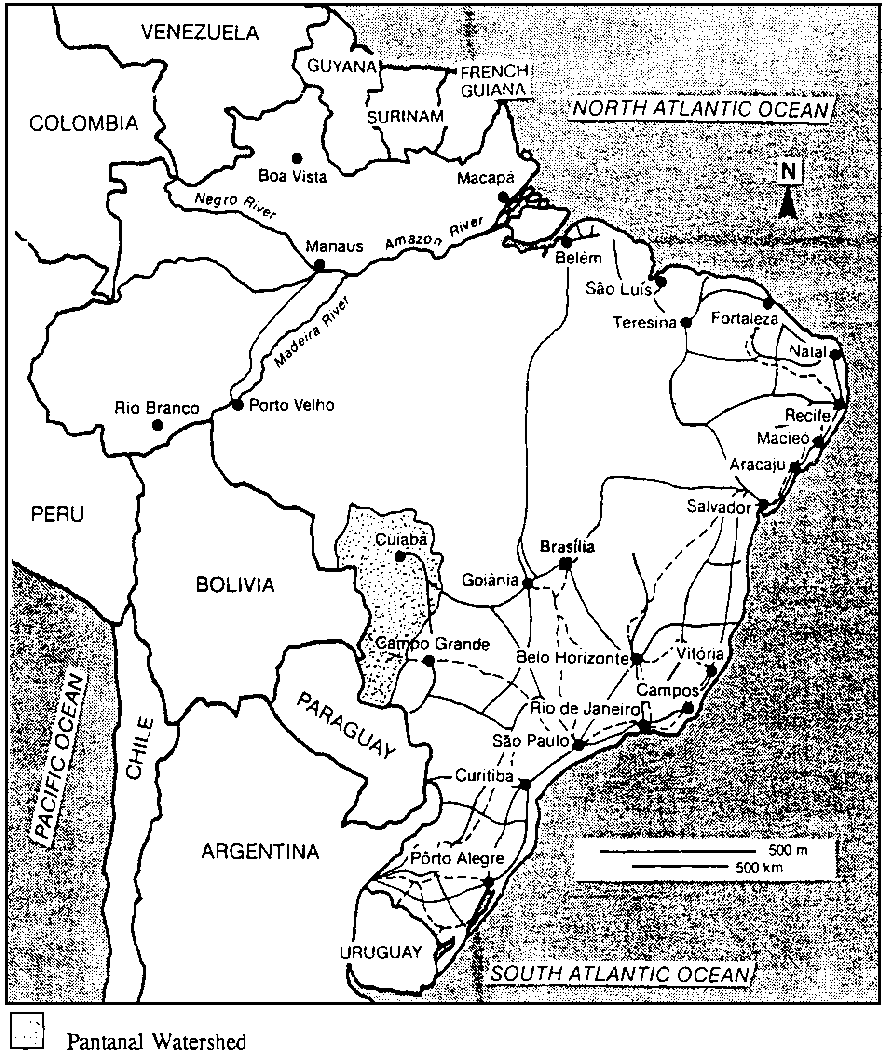
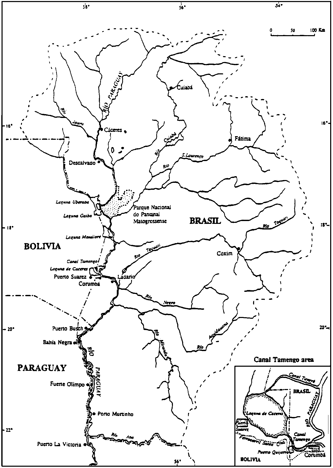
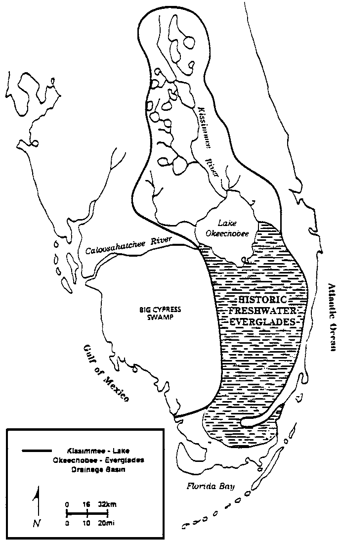
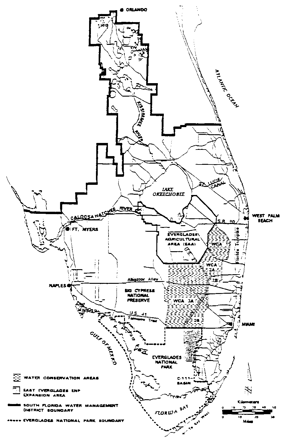
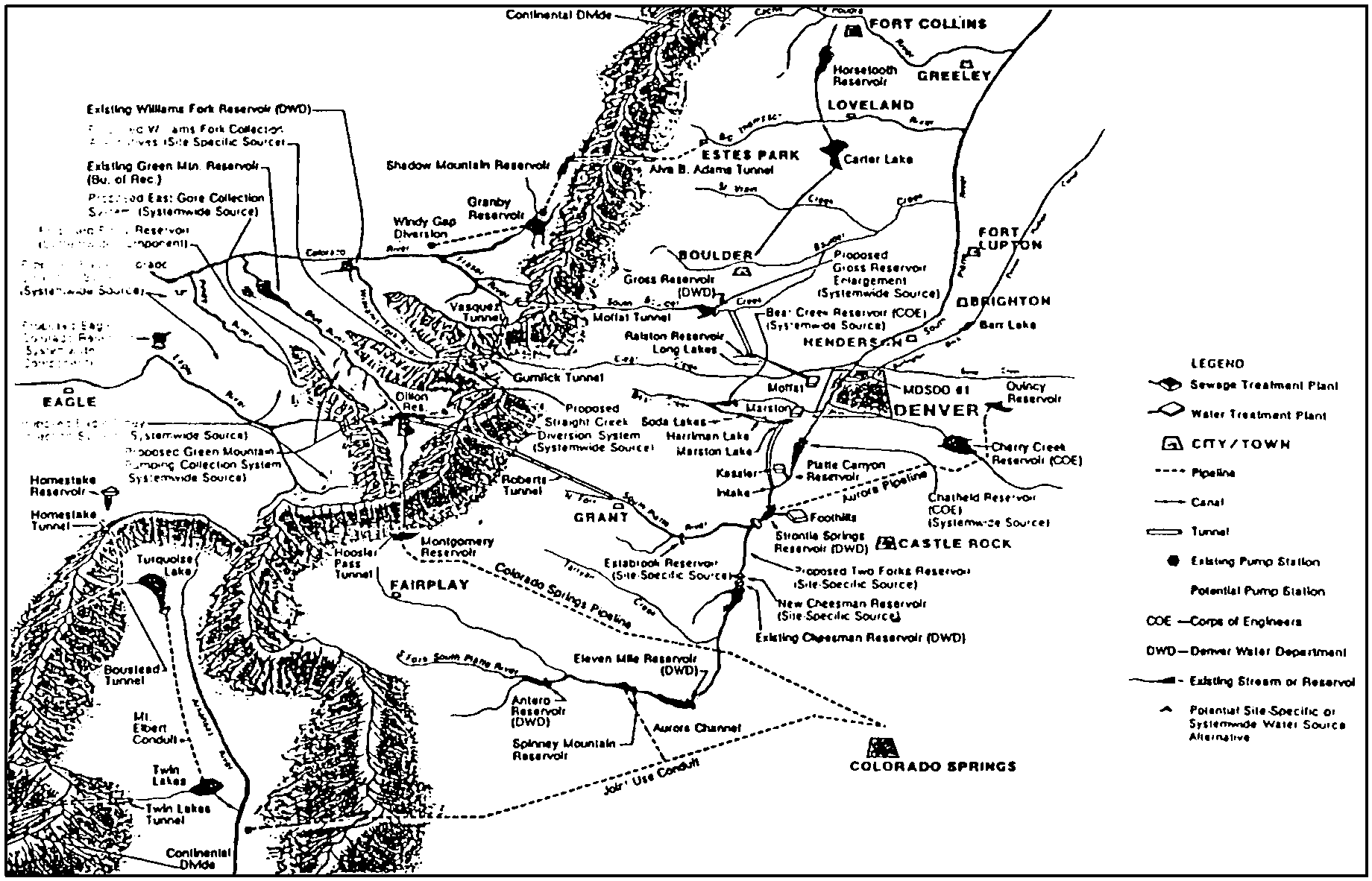