![]()
![]()
![]()
![]()
![]()
4.1 Background and origin of the project
4.2 Resources of the Valley: land and people
4.3 The socio-technical problems: four settlements in the Valley
4.4 Exploring development alternatives
4.5 Project reassessment and the first years of tenure rationalization
![]()
As stated in chapter 2, the Morne Panache Pilot Project team cancelled a planned resettlement programme because the 120 acres available for redistribution were insufficient to effectively reduce land scarcity in the Project area. In the wider context of the Mabouya Valley, a pilot exercise of this scale could not fully address the important link between demand for land by small farmers; the existence of near by, highly productive, yet under-utilized, flat lands; and the environmental degradation caused by increasing encroachment on forested slopes and the Forest Reserve.
Analysis of the Pilot Project suggested that the Mabouya Valley region would be a particularly good area in which to implement a larger integrated development strategy. Two further developments, discussed below, contributed to making this possible.
Early in 1983 the Central Planning Unit (CPU) of the Saint Lucia Ministry of Finance and Planning endorsed the subdivision of the 2,613 acre Dennery Farmco property that stretched westward into the valley from Fond D'or Bay. Formerly a single-family estate and historically the dominant local economic institution, the Farmco property had long been in decline. The property's financial situation and had not improved since its purchase by the Government in 1978. (see section 4.4.1).
Secondly, negotiations between the Saint Lucia Government and the Commission of European Communities resulted in the approval of a drainage and conservation project at three sites in Saint Lucia. Funding for the project came from a grant of EC$ 3.803 million from the European Development Fund (EDF), under the Lomé III Agreement (which provides aid to former colonies in Africa, the Caribbean and the Pacific). One of the three sites selected was Fond D'Or, a sub-catchment in the Mabouya watershed, where silting, water-logging, and flash flooding had curtailed banana production on 272 acres of Farmco lands.
During the latter part of 1983, in anticipation of the Mabouya Valley Project then under consideration by the CPU, the Land Reform Unit of the Agricultural Ministry and the OAS surveyed households in four settlements in the valley. (Section 4.3 looks at the results of the survey as well as the LRU/OAS recommendations for a resettlement programme.) In keeping with previous activities of the OAS in Saint Lucia, the survey was based on the principle that land, in addition to being a critical resource element in the socio-economic transformation of agrarian structures, is also an integral element of the total resource endowment of the society.15 This endowment is composed not only of environmental factors but also of people in communities, their history, culture, needs and aspirations. People are the most important part in any process of social transformation.
15 L. Strachan, Pilot Project of Land Redistribution in the Home Panache Area: Project Profile. Castries, Government of Saint Lucia and the OAS, September, 1981.
The CPU and the Office of the Prime Minister, to which the Ministry of Finance and Planning is attached, came to share this comprehensive approach. With the dissolution of the Land Reform Unit at the end of 1983, the CPU became the sole agency for technical cooperation in the valley. The CPU Physical Planning Department assumed a major role in developing a sound proposal for land use on the Farmco estate.
Along the same conceptual lines, the drainage problems on the floor of the valley, targeted by the EDF project, were inextricably linked to land scarcity. Shortages in land had induced small farmers to clear the steep slopes on surrounding hillsides for food crops and firewood. This clearing resulted in erosion and sedimentation of the drainage channels. Repairing the physical infrastructure on the valley floor, by itself, would be a temporary and economically wasteful measure, failing to address the cause of the problem.
Through the work of the OAS in the Mabouya Valley, the EDF became aware of the role that land scarcity had played in soil erosion. Hunting Technical Services, consultant to EDF, identified the need to expand the scope of their project beyond drainage relief. In their proposal, EDF adopted the view of the OAS and the CPU: although drainage repairs were needed immediately, an integrated approach to the development of the Mabouya Valley was the only rational and cost-effective solution in the long-term.
Along hillsides areas where farmers had cleared the forest cover, soils were unstable and vulnerable to landslip. The flat, low-lying valley bottom (0.5-1.5 meters above sea level), a swampy area prior to its drainage for agriculture, contained soils made up of clays and clay loams allowing very slow internal drainage. Hunting Technical Services, the EDF consultant, concluded that closely-spaced field drains two-feet deep and collector drains 3.3 feet deep were needed for banana production on the valley floor. The depth of soil above the water table was considered suitable for most annual crops.16
16 Hunting Technical Services Ltd., The Roseau. Dennery and Cul de Sac Drainage and Conservation Project. CPU and Ministry of Finance and Planning, Castries, 1984.
Average annual rainfall ranged from 117 inches (2972 mm) at the head of the valley (Barre de l'Isle) to 77 inches (1956 mm) at La Caye. Depending on the intensity of the dry season (January to May), the base flow of the Mabouya and Derniere rivers could provide enough water to irrigate 100 to 300 acres. The core estate contained 200 acres (70 ha) under fixed-set irrigation. In 1978 an EDF-financed study had identified a reservoir site at Grand Ravine that could store 1.22 million cubic meters of water and supply the entire valley by pipeline. This reservoir could provide enough water to irrigate the valley floor as well as to provide for an ample domestic supply.
One of the most appealing features of this catchment area, in terms of its development potential, was that it contained the largest expanse of flat fertile land on the windward side of Saint Lucia. During its most productive exploitation, the Dennery Estate was widely known as a source of tremendous wealth.
Table 4-1 shows the land capability in the catchment area and on the Farmco estate.
Table 4-1: Land Capability and Potential Land Use, Mabouya Valley and Farmco Estate
|
Land capability classes and crop suitability |
Mabouya Valley |
Farmco Estate |
|||||
|
Acres |
Ha |
% |
Acres |
Ha |
% |
||
|
I |
Vegetables |
|
|
|
|
|
|
|
II |
and |
|
|
|
|
|
|
|
III |
bananas |
1,203 |
487 |
12 |
724 |
293 |
28 |
|
V |
Non-cultivable; |
|
|
|
|
|
|
|
VI |
permanent crops |
2,416 |
978 |
24 |
388 |
157 |
15 |
|
VII |
Protection |
|
|
|
|
|
|
|
VIII |
Forest |
6,370 |
2,578 |
64 |
1,499 |
607 |
57 |
|
Total |
9,989 |
4,043 |
100 |
2,611 |
1,057 |
100 |
|
Sources: OAS (1981) and HTS (1984).
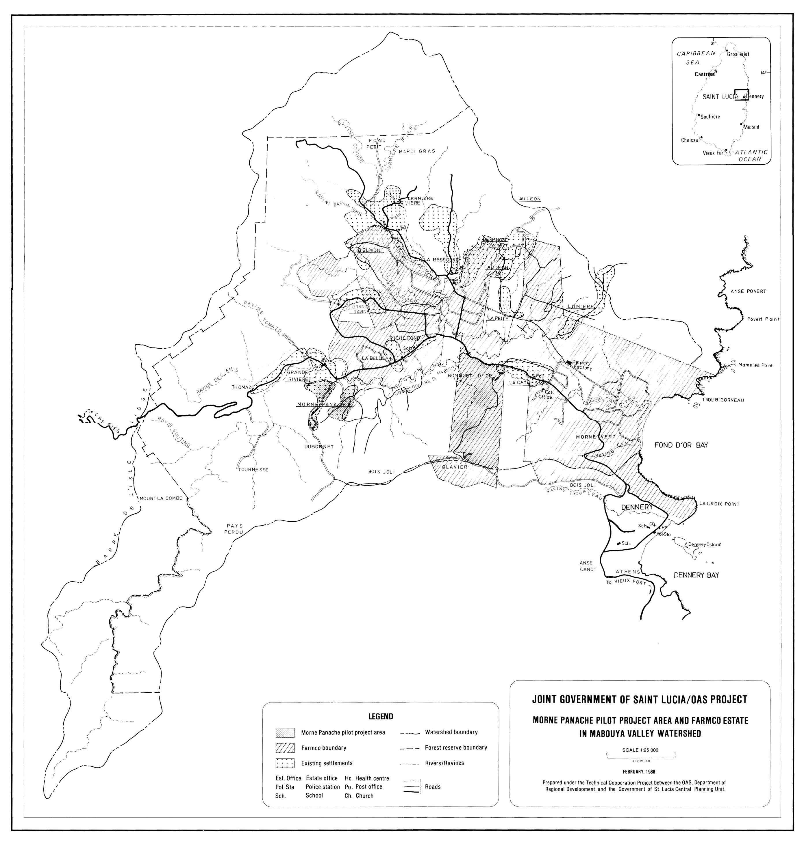
A quarter of the estimated valley population (7,500) lived on Farmco lands at the beginning of the Project. Eight settlements (Riche Fond, Grand Ravine, Belmont, Despinoze, La Perle, Limiere, La Caye, and Au Leon) with an total estimated population of 4,000, were situated on or near the estate. The Project team included these communities in the Project area as these people would be most concerned about the drainage and land-use problems of the valley. Table 4-2 lists the main characteristics of these communities.
Historically, the communities were the source of wage labour for the estate. Local residents claimed that as many as 1,200 to 1,500 persons used to work for the estate. By 1985 there were fewer than 300 casual labourers on the estate and about 50 full-time employees, including a general manager, an accountant, and two section managers.
The results of the Land Reform Unit/OAS survey in four valley settlements may be considered reasonably applicable to the others. Table 4-3 lists the household incomes as reported by the survey. Respondents in the highest bracket received cash income from sources other than the sale of crops. The income figures show that the ability of the residents to pay for land would be extremely limited, as their incomes also covered household expenses.
Table 4-2: Rural Settlements in the Development Programme
|
|
Number of households |
Area |
Density |
Deficiencies and problems |
|
Au Leon |
230 a/ |
41.8 |
5.5 |
Erosion |
|
|
|
|
|
Devegetation |
|
|
|
Garbage disposal |
||
|
|
|
Footpaths |
||
|
|
|
Land tenure |
||
|
|
|
Public conveniences |
||
|
Despinoze |
58 b/ |
17.8 |
3.3 |
MiId erosion |
|
|
|
|
Footpaths |
|
|
|
|
Land tenure |
||
|
|
|
Public conveniences |
||
|
Limiere |
23 c/ |
8.5 |
2.7 |
Electricity |
|
|
|
|
|
Water supply |
|
|
|
Erosion |
||
|
|
|
Footpaths |
||
|
|
|
Land tenure |
||
|
|
|
Public conveniences |
||
|
|
|
Accessibility |
||
|
La Perle |
10 c/ |
8.5 |
1.2 |
Electricity |
|
|
|
|
|
Water supply |
|
|
|
Accessibility |
||
|
|
|
Footpaths |
||
|
|
|
Land tenure |
||
|
|
|
Public conveniences |
||
|
La Caye |
140 b/ |
34.4 |
4.1 |
Land tenure |
|
Belmont |
147 d/ |
22.4 |
6.6 |
Accessibility |
|
|
|
|
|
Footpaths |
|
|
|
Land tenure |
||
|
|
|
Public conveniences |
||
|
Grand Ravine |
139 d/ |
22.7 |
6.1 |
Land tenure |
|
|
|
|
|
Public conveniences |
|
Riche Fond |
123 d/ |
30.2 |
4.1 |
Public conveniences |
|
|
|
|
|
Land tenure (Belle Vie only) |
|
Total |
870 |
186.3 |
|
|
|
a/ |
Field estimate, 1985. |
b/ |
Identification of rural settlements (OAS, 1983 a). |
|
c/ |
House count in the field, 1985. |
d/ |
Socio-economic survey (OAS/LRU, 1983). |
Table 4-3: Monthly Household Cash Income
|
AVERAGE INCOME (EC$)
|
SOURCE OF INCOME |
|||
|
Sale of crops |
Other |
|||
|
No. households |
% |
No. households |
% |
|
|
333$ |
|
|
49 |
32% |
|
150$ |
41 |
53% |
78 |
51% |
|
33$ |
25 |
32% |
19 |
12% |
|
10$ |
12 |
15% |
8 |
5% |
|
|
78 |
100% |
154 |
100% |
Source: OAS/LRU (1983).
A less concentrated settlement pattern had occurred outside the estate at Au Leon, on a narrow ridge mainly occupied by squatters on Crown land. Additional settlements, in a more dispersed and linear pattern, had grown along access routes. Construction of the Cul de Sac road across the island had caused the price of house-lots on adjoining land to rise.
All the villages were still affected by efforts of the Dennery Factory to sell land to factory workers in 1973 and 1974. Nearly all of these lots, although occupied, had not been paid for. In the Riche Fond/Belle Vie areas, where the Saint Lucia Housing Authority had conducted a subdivision programme in 1981, only 15 percent of the people had paid for the land they received. This created a dilemma: authorities were reluctant to evict persons who had not paid, but also reluctant to condone squatting which could lead to the occupation of private as well as Government land. With the completion of the land-registration programme, it was expected that legal title could be regularized.
The development and growth or ultimate retrogression and decay of the villages of Riche fond, Grand Ravine, Belmont, and the settlement cluster of Morne La Silence/Morne Panache17 (see Map 2) were inevitably linked to the fortunes or failure of the surrounding Farmco lands. Within these four settlements were a little over 400 households and a population of about 1,600 persons.18
17 This is a different Morne Panache than the area denoted by the Morne Panache Pilot Project.18 Report on the Socio-economic Survey of Rural Communities in Farmco Lands. Castries, December, 1983.
The household survey carried out by the Land Reform Unit and the OAS established that the primary occupation of almost 64 percent of household heads was either own-account farming on small plots of Farmco land (37 percent) or employment as wage labourers for Farmco (26 percent). These were also the most important second occupations (57 percent and 24 percent, respectively) among the 27 percent who held two jobs. Almost 25 percent of the heads of household had previously worked as wage labourers at Farmco but had since been laid off. Nearly all the houses in Belmont and Grand Ravine, a third of those in Riche Fond, and almost none in Morne La Silence/Morne Panache were situated on Farmco lands.
Whether on or off Farmco lands, holdings were predominantly less than one acre: 83 percent in Morne La Silence/Morne Panache, 82 percent in Grand Ravine and in Belmont. In Riche Fond, only 49 percent of the parcels were less than one acre. However, 39 percent of the Riche Fond respondents indicated they did not know the size of their parcels.
Allowing for the fact that a number of household heads farmed more than one parcel, it remained striking that very few of the primarily farming-dependant households operated holdings of five acres or more. Five acres is usually considered the minimum viable farm size. The resulting low incomes from the sale of their crops explain why some 75 percent of the households expressed a need for additional land.
Nearly two thirds of the adult population of the four communities (546) were employed: 70 percent in Grand Ravine, 62 percent in Belmont, 61 percent in Riche Fond, and 54 percent in Morne La Silence-Morne Panache. Very few children helped with farming: 8 percent in Belmont and 9 percent in Morne La Silence -Morne Panache.
The information received on economic returns from farming activities may not be particularly reliable, given the relatively low response rate (less than 50 percent), yet it was certainly instructive that only 156 household heads (about 5 percent) stated that they received more than EC$ 200 a month from crop sales.
A majority of respondents throughout the four settlements stated that their reason for wanting additional land was to provide for a "house and garden." (In Grand Ravine, where 74 percent of the respondents occupied rent-free house-lots on Farmco lands, the need for land was less pronounced.) The desired amount of land, however, averaged between one and two acres. Hence, what individual households wanted was simply a minimum additional holding that they perceived as adequate to improve their productive capacity and provide shelter for their family. Fewer than 15 percent stated that they wanted more than five acres of additional land.
On the basis of the amount of additional land requested, an effective subdivision of Farmco lands would require more than 900 acres. On a more realistic basis of an acre and a half for households having family labour to work additional land, 500 acres would suffice.
It was clear that most of the respondents would put additional lands to typical use: mixed subsistence and cash crop farming, and would use household labour to farm the land.
The great majority indicated a willingness to contribute towards the cost of the land. However, given the average low incomes in the communities, most would only be able to manage a down payment between EC$ 100 and EC$ 500.
Taking into account this preparatory study, the Land Reform Unit and the OAS recommended guidelines for a Farmco subdivision and land-distribution programme as follows:
1. The programme should satisfy as much as possible the high demand for house-lots through regularization and upgrading of present settlement structures, rather than through expansion.2. The programme should give priority for the acquisition of farmland to those whose first occupation is farming and who currently have access only to Farmco lands.
3. In determining farm size, the programme should place emphasis on the farmers' capacity, level of aspiration, and household labour supply over the more theoretical considerations of "economic" farm size.
4. The programme should require farmers to actively consolidate holdings in order to participate in the subdivision programme.
The study also presented a matrix of varying levels and locations of farming activity correlated with existing housing locations. This matrix was later used as a framework for assigning priority in the subdivision programme.
The study emphasized the necessity of a solid credit mechanism in enabling the poorer applicants to acquire land in a subdivision programme. As similar groups outside the Project area needed credit as much as the small farmers and farm labourers in the Mabouya Valley, the study recommended the establishment of a national institution such as a land bank (also recommended in the Morne Panache Project proposal and in discussions at the Symposium).
![]()
4.4.1 The Institutional Framework
4.4.2 Development Proposals
![]()
By the Spring of 1984 the first phase of the drainage project was under way. On May 22, at the initiative of the EDF, the Prime Minister appointed an Advisory Committee for Dennery Basin Development to pursue a comprehensive strategy for the valley and to advise the Government on the disposition of Farmco lands and all ongoing valley projects. To assist in formulating an integrated resource management strategy, the OAS provided two consultants - an agricultural planner and a human-services expert - for four person-months, in addition to the continuing services of the resident Project Chief.
Members of the Advisory Committee included representatives of the National Development Corporation; Saint Lucia Model Farms Ltd.19; Dennery Farmco Ltd.; the Extension Division, Forestry Division, and Agricultural Engineering Services of the Ministry of Agriculture; the Physical Planning Section of the Central Planning Unit; the Ministry of Community Development; and the local representative in Parliament.
19 A local company formed as a joint venture for a land development programme in the Roseau Valley, one of the other three large expanses of flat, fertile land in Saint Lucia. Shareholders included the UK-based Geest Industries, the Commonwealth Development Corporation, and the Government, which obtained financing for a high-cost EC$ 22 million project to settle and provide 200 farmers with inputs for bananas and an exotic tree-crop programme of mangoes and avocadoes.
The Committee's specific goals were to define the core estate for Farmco operations, address the demand for housing and agricultural land in the area, advise on the resettlement of watershed squatters, advise on the protection and reforestation of the watershed, define the valley drainage project, and estimate the financial requirements of the entire programme.
Over the next year the Committee arrived at a series of recommendations (published in the Committee's Draft Report. April 1985) having four major interrelated objectives: increased production and income from the core estate of about 350 acres; improved living conditions for the resident population; access to suitable land for subsistence; and the introduction of essential soil and water conservation measures.20
20 Advisory Committee for Dennery Basin Development, Draft Report. April 1985.
The Committee's report provided a comprehensive analysis of the problems affecting agricultural production and the quality of human life in the Mabouya Valley. The report addressed: (1) physical resources, (2) human resources and rural settlements, (3) agriculture and forests (land tenure and use), (4) the institutional framework, (5) development objectives and strategy, (6) development proposals, (7) organization and management, and (8) programme costs and benefits.
To avoid the problems encountered by Farmco's previous attempts to redistribute land (section 4.2) the Committee recommended the following specific elements to be included in the development strategy:
1. Close consultation with community leaders.2. To receive title, local residents should contribute resources to environmental improvements, such as the construction of retaining walls and drainage channels, and the realignment of tracks and roads.
3. Programmes should not give away land, but allow purchasers to pay according to their means. Subsidies should be available for disadvantaged people.
4. People should pay at least the survey costs.
5. Eligibility for benefits should be subject to residency of at least two years on site prior to 1984.
6. Programmes should not permit the transfer of title, except to heirs, within 10 years of the initial transfer.
The Committee subsequently specified the extent of the land area and accompanying mechanisms for regularization in its comprehensive programme.
For the purposes of the present study and in the light of the previous account of the OAS-sponsored activities in Morne Panache and surrounding settlements, the remaining discussion will focus on two sections of the Committee's report that dealt with the institutional framework and the development proposals.
Any development strategy designed for the communities in the valley would need to take account of the available institutional services that could help implement such a strategy. Four institutions existed in the Mabouya Valley at the beginning of the Project:
1. Governmental services. To a limited extent, there were in place staff and services geared toward the critical areas of agricultural extension, forestry, and community development. Additional services from Castries - water, electricity, physical planning - served the area in an ad hoc manner. The overall coordination of Government services was left to the Parliamentary Representative. No local Government administrator possessed authority over environmental matters, building regulations, or community facilities.
2. Mother's and Father's Organizations. Although individual communities held strongly independent views, Mothers' and Fathers' Organizations were active in the area, having elected officers and pursuing educational and social welfare work among the disadvantaged. These organizations were particularly well placed by their strength and non-sectarian character to provide support for the implementation of local-level programmes.
3. Dennery Farmco Ltd. By 1978, when the Government purchased the lands and buildings, the Dennery Estate had been losing money for at least the previous three years.21 Although the valley was the largest banana-producing area in the country, the estate's share of the production had fallen to less than a third. The Saint Lucia Government established a state-owned corporation, National Landco Ltd., to lease the land to Dennery Farmco. Dennery Farmco then purchased the estate's operating assets.
21 L.J.T. Smallbone, Dennery Estate Valuation. Commonwealth Secretariat, London, 1978.
Farmco was to be financed by a combination of equity shares, overdraft facilities, and long-term loans. The 1979 national elections caused a delay of this financing and Farmco began operations in advance of the required capital. An ambitious plan prepared by the management in 1977 included items such as the expansion of vegetable-growing for export to the European off-season market and the installation of irrigation for 600 acres. Yet within a year it became apparent that the cost assumptions on which the plan was based were too optimistic, having ignored the run-down state of the infrastructure, especially the roads, drainage system, and buildings. Farmco abandoned vegetable production following repeated damage from flash foods. Cultivation practices declined and working capital remained short. Returns could not cover operating costs.
In early 1980, the 1977 plan was revised to include as an immediate priority an overhaul of existing operations - the rehabilitation of drainage, buildings, and farm roads; an improvement in labour efficiency; the expansion of the irrigation system installed in 1979; and pilot programmes for diversification into papaya, vegetables and livestock.
Hurricane Allen interrupted the implementation of the revised plan, destroying the banana crop and some mango, kola, limes, and coconuts. This, together with the continuing cash crisis, low banana prices (due to the falling pound sterling), and increasing input costs, culminated in a curtailment of normal agronomic operations in late 1981. A strike by estate workers in protest against lay-offs followed in February 1982. Later that year Farmco sold its cattle and closed its least profitable sections to reduce costs. In 1984 Farmco incurred an operating loss of EC$ 652,000, and by March 1985 the liabilities were in excess of EC$ 3.5 million. Clearly, the Government would need to resolve the production difficulties on the "core" area of the estate if the estate was to play an essential role in the programme for rural reconstruction.
4. The Banana Growers' Association. There were two extension workers from the Association working in the Mabouya Valley. In addition to providing inputs, the extension staff played an important role in improving the quality of the fruit and in introducing field packing and other recommended practices. Following the boom in banana prices and production in late 1985 and, due to the strengthening of the pound sterling and improved technologies, the influence of the Association increased. The Advisory Committee concluded that the Association could make a decisive contribution to a comprehensive development programme, by teaching growers to avoid over production, providing crop insurance, and encouraging diversification.
To meet its objectives through integrated development, the Advisory Committee designed six components to the Mabouya Valley Project: (1) a rural settlement scheme; (2) garden allotments; (3) hillside farms and erosion control; (4) a forestry programme; (5) coastal zone development; and (6) rehabilitation of the core estate.
1. Rural Settlement
The rural settlement scheme would accommodate population growth within the valley, upgrade the social infrastructure, and provide alternative residential sites for communities occupying lands at high risk of erosion. The Committee recommended increasing housing density to nine households per acre, with a minimum lot size of 3,000 square feet, and concentrating expansion in areas where development costs were lowest. The legal ownership of house-lots would be transferred to their current occupiers. The physical improvements would include retaining walls, domestic water supply, footpaths, public facilities, electricity, and garbage pits.
The Committee estimated the total cost of the upgraded social infrastructure, with varying costs per household, at approximately EC$ 990,000 for the existing settlements. The housing expansions, at approximately EC$ 13,208 per acre, would cost an estimated EC$ 1.3 million.
2. Garden Allotments
The garden allotments were intended to help households feed themselves while providing an opportunity for cash income from marketing the surplus. The allotments, covering up to about 100 acres in all, would vary from one square chain (484 square yards) to a quarter of an acre.
The importance of these plots as a source of starchy vegetables (dasheen, tannia, yam, sweet potato, cassava, and plantain) has a long tradition, dating from the slave plantation era. These gardens were also found in the four settlements surveyed by the OAS in 1983. Farmco itself was still renting out small patches of land for this purpose.
The novelty of the Committee's proposal was that the practice would be formalized by strict controls on tenure, and would disencumber hillside lands that could then be leased as small farms and provide an alternative and more productive location to squatters who were cultivating small gardens in the Forest Reserve.
3. Hillside Farms and Erosion Control
The creation of viable hillside farms and the implementation of erosion-control measures in the valley constituted a dual strategy aimed at using appropriate resource management to facilitate increased production.
250 acres outside the core estate were considered suitable for hillside farms of 5 to 10 acres devoted to root crops, bananas, coconuts, mangoes, breadfruit, citrus, and pasture.
The Committee examined two approaches that were currently being followed in Saint Lucia:
1. The Roseau Valley approach, in which 10-acre hillside plots were developed by a local company, Saint Lucia Model Farms, and provided to farmers in a complex lease/purchase arrangement that included the provision of supporting services at a charge or "additional rent."2. The Cul de Sac Valley scheme, based on free-hold purchase of 10 to 15 acre hillside plots, in which buyers raised their own capital and obtained the usual Government assistance available to the general farming public.
The Advisory Committee chose and modified the second approach to include a lease/purchase arrangement available to local farmers with specific income and residence qualifications. Lease/purchase, as opposed to outright sale, was rightly thought to allow for some control over land-use and building on hillsides. Landco would retain administrative and managerial functions. Conservation practices would be taught through extension programmes and additional measures taken to ensure good husbandry.
The question of farm size was the subject of much discussion. A Ministry study had recommended eight acres as optimum.22 Hunting Technical Services proposed in its report that a minimum of ten acres was required if families were to repay their loans over a 15-year period, hire labour, and keep a reasonable income for themselves. Due to the amount of land available, the number of farmers interested in buying land, and the fact that most of the farmers received secondary income from non-farming sources, the Committee chose to make five-acre lots available to the farmers.
22 Ministry of Agriculture and CPU, Optimum Farm Sizes for Resettlement Farms in the Mabouya Valley, Castries, 1983.
The transfer of hillside lands to individual farm holdings would require appropriate organizational arrangements and would be a major economic and social cost of resettlement. Additional costs would also be involved in upgrading tracks into roads for vehicular access to an area that would eventually contain about 147 households.
For environmental protection, sub-catchment committees would be formed to assist in the construction of graded terraces, storm-water drains, and grassed waterways, and to work on tree planting, intercropping and reforestation.
As the Extension Division of the Ministry would have a pivotal role, a pilot programme stressing greater community involvement through farmers' committees was under consideration.
Some of the proposed hillside farms or garden allotments would be offered to the estimated 107 squatters from the villages of Au Leon, Gadette, and Derniere Riviere who had been cultivating about 20 percent of the 735 acres of Forest Reserve in the valley.
Because the Committee did not envision additional compensation, there were no expectations for any major direct expenditures by the Government, except to cover the cost of the replanting and maintenance of 150 acres of Forest Reserve over five years.
4. Forestry Programme and Coastal Development
The forestry component would establish village woodlots to provide charcoal and firewood, reforestation to create buffer zones between the hillside farms and the woodlots, and a nursery. The woodlots would be developed on five-acre plots in the vicinity of four communities. The Committee estimated the total cost of these activities at EC$ 554,000.
The proposals for coastal development in the lower reaches of the valley offered the possibility to combine the concern of the Forestry Division to retain the natural beauty of the area, including beach, river estuary, and mangrove, with the desire of the National Development Corporation to develop the area for tourism.
5. The Core Estate
The decline of plantation agriculture began with the abolition of slavery in 1834. Decline continued through the increasing unionization of estate workers in the 1950s and the rising demands for land reform, with open aggression against foreign and absentee ownership. By the 1970s, the plantation system was disintegrating throughout the Caribbean.23
23 The seminal work on these issues by West Indian scholars is best portrayed in the Proceedings of the Third West Indies Agricultural Economics Conference. University of the West Indies, St. Augustine, 1968. The study by George Beckford, who subsequently chaired the Saint Lucia Land Reform Commission in 1979, entitled Persistent Poverty. (Oxford University Press, 1972), remains a classic statement on plantation agriculture.
Historically, the concentration of labour and resources on the better lands of the plantation provided the basis for the plantation economy and its accompanying social organization of production. This was the "core estate." Owners usually allowed labourers to use the marginal lands along the periphery for subsistence gardening. In the case of Dennery Farmco, while the deed of sale in December 1979 listed the total estate at 2,613 acres, the prime agricultural lands reserved for intensive cropping consisted of 825.43 acres in 15 sections.24 Common to all plantations, the loss of control over labour and the lack of capital investment in mechanization and irrigation meant constantly diminishing output and a limited scale of operations concentrated mainly in the core estate.
24 Advisory Committee for the Dennery Basin Development, op. cit.. p. 10.
In this regard, a major contribution of the Advisory Committee was its assessment of the three possible options for the future development of the core estate. These options were: plantation rehabilitation, retention of a core estate and subdivision of outlying lands, and subdivision of the entire estate into small farms.
Option (a): Plantation Rehabilitation
Plantation rehabilitation would place the core estate into full production under a centralized management system reminiscent of former days. The Government would inject capital and strengthen management to the level of competence necessary for an operation on a scale of more than 800 acres.
Rehabilitation constituted the least plausible option. The various attempts at revival in the preceding decade had led only to increasing losses.
More importantly, plantation operations on such a unwieldy scale, with a corporate structure that created alienation in the workers, were fast becoming obsolete. In addition, because of statements by political leaders, the OAS surveys in the area, and the failure of the estate management to prevent encroachment by squatters, local residents were under the distinct impression that the Project would include subdivision for the benefit of squatters, estate labourers, and other landless people.
In assessing this option, the Advisory Committee believed that "even if the necessary finance, market opportunities and management skills were forthcoming, it [was] unlikely that a large plantation could ever again operate successfully in the Mabouya Valley.25
25 Advisory Committee ... , op. cit., p. 46.
Option (b): A Nuclear Estate with Small-holder Satellite Farms
This option called for the maintenance of a core estate on 350 acres and small satellite farms spread over an additional 170 acres that were being reclaimed by the EDF-sponsored drainage project. This was essentially an interim proposal: while subdivision of the entire core estate might be the most desirable alternative in the long term, a decision on the 353 acres currently under banana production could be postponed for a few years. The Committee raised three counter-arguments:
1. Even though the Mabouya Valley Development Project might take the pressure off estate lands and reduce expenditures on security and maintenance, the Project was unlikely to overcome the structural problems of the Farmco operation.2. Farmco's overhead of EC$ 1.051 million in 1984 represented a charge of EC$ 3,000 on every acre of bananas. The operation could not be profitable without a radical pruning of these costs and a significant increase in the productivity of management and labour. This would be difficult to achieve under any circumstances, but with the additional burden of smallholder development it would be impossible.
3. Once the decision had been made to go ahead with the subdivision of part of the core estate, there was no advantage to be gained from stopping half-way, no economies of scale that would justify retaining a nuclear estate in combination with smallholdings.
Option (c): Subdivision of the Entire Estate
Given the perennial financial problems of Farmco, the Advisory Committee considered that the question was no longer whether or not to subdivide, but when to subdivide. Furthermore, the successes reported to have followed the subdivision of the former Geest estates at Roseau and Cul de Sac made it tenable to suggest subdividing the core estate into five-acre farms within a few months. Including the land reclaimed in the Fond D'Or section, a total of 97 five-acre farms could become available between January 1986 and June 1987.
Farmco would have to be kept in operation until another organization could take over, if only to prevent a mass occupation of the core estate by local residents, as had occurred on the periphery. This new organization, to be established with aid financing, would provide services to the settlers. These settlers would be local farmers with modest incomes and a readiness to farm according to acceptable standards. Landco would supervise land surveys, demarcation, allocation, and rent collection.
Under interim tenure arrangements, the Government would initially lease the plots for renewable one-year terms with rents assessed according to productivity. Subsequently, the farmers would sign a 15-year lease/purchase agreement, in which the rent would be used to amortise the costs of the land and of any land development or management.
The Committee could not agree on whether there should be a tightly controlled system of supervision, as practiced by Saint Lucia Model Farms, or a looser arrangement with a minimum package of services.
A minimum package would include services for land administration, irrigation and drainage, extension, input supply, marketing, and credit. These services would have both recurrent and capital costs. While the former were estimated, they were not considered programme costs because they would be recouped from tenants. Capital costs, on the other hand, might or might not be recouped and would have to be met before the programme could be started. Spread over the first two years of the programme, capital costs would amount to about EC $ 1.24 million (See table 4-4).
Table 4-4: Capital Costs
|
Item |
1986 |
1987 |
|
Survey |
186,780 |
43,120 |
|
Legal fees |
30,000 |
10,000 |
|
Roads |
153,091 |
153,090 |
|
Irrigation |
476,403 |
|
|
Land preparation |
39,000 |
47,500 |
|
Office equipment |
10,000 |
|
|
Transport |
40,000 |
|
|
Tractor and trailer |
48,000 |
|
|
Total |
983,274 |
253,710 |
The Advisory Committee believed that a grant could legitimately cover these costs.
The Committee estimated the annual recurrent costs at EC$ 340,000, or about EC$ 580 per acre of leased valley-bottom land. This amounted to about half the current overhead of Farmco. Extension services provided by the Banana Growers' Association and the Ministry of Agriculture would cost an additional EC$ 25,000 per annum, or about EC$ 30 per acre.
In contrast to the minimum package, a Model Farms approach would consist (as it did in Roseau) of an array of services - land development, extension, input supply, credit, and marketing - for which a company (SERVCO) would be set up. Before each holding was turned over to a settler, the soil would be re-worked, new drains built, and bananas planted and cared for up to eight weeks before the first harvest. Previously, the settler would have been employed as a daily paid labourer and would have assisted in the preparation of his holding. Regular instruction in techniques of banana production would be given by Servco staff, who would monitor settlers' input/output accounts on computer. Each farm would be inspected weekly, and farmers scoring low in any respect would receive further attention.
Servco's central store would provide all the necessary farm inputs on account and pay the farmers a regular advance of EC$ 80 per week and EC$ 1 per box of bananas delivered. Detailed statements would be prepared quarterly, itemizing all debits and offsetting these against banana sales. Individual settlers would box the fruit, but Servco would market the produce, delivering it in company trucks to the Growers' Association at the pier.
The essential difference between the minimum package and the Servco operation is that the aim of Servco would be to retain sufficient control over the production system to ensure high yields and repayment to the company of the land development costs. However, this would require large loan payments, EC$ 1,028 quarterly or EC$ 4,112 per annum for a five-acre farm, plus an annual management overhead charge of EC$ 7,000, or a total of EC$ 11,112 per farm. With the minimum package, using the costs estimated above and assuming a price of EC$ 6,000 per acre or EC$ 30,000 for a five-acre farm, the annual payments would be EC$ 3,047 for basic rent and EC$ 2,906 for overhead, for the substantially lower total of EC$ 5,953 per farm.
Despite lower yields, the Advisory Committee considered the minimum package to be more secure and cost-effective.
The committee divided its recommendations between options (b) and (c) . These recommendations were delineated in a draft report of April 1985 and made known to the Prime Minister and Cabinet in a presentation in September of that year.
Rather than leading to an early response by Cabinet, the Advisory Committee's submission turned out to be the initial step in a complex process of project reassessment.
Following a nine-month hiatus, during which time the views of the Government remained unknown, the Minister of Agriculture revived the Advisory Committee. At a meeting on June 27, 1986, the Advisory Committee appointed a Mabouya Valley
Development Committee, with representatives from several Ministry divisions, the CPU, Landco, and the community, to work on the following issues identified by the Minister: the size of the Farmco core-estate,26 a distribution policy for lands outside the core-estate, a survey of occupied areas, the acquisition of private hillside lands, and the allocation of lands for specific uses. Meanwhile, the Economic Planning Section of the CPU proceeded with the preparation of the final document on the EDF project.
26 By this time, enthusiasm to dispose of the core estate had waned due to increased banana prices in 1986, which continued in 1987, enabling Farmco to repay its debts, obtain improvement in capital costs, and realize a profit of EC$ 250,000.
To keep alive the process for an integrated development strategy in the valley during this period, the OAS contracted in September 1986 a local agricultural specialist to serve as a Programme Officer for twelve months. The Programme Officer would help design and implement Phase I of the Mabouya Valley Development Project by carrying out those activities that were possible without external funding. Secondary resources were sought and gained from other Government agencies, Farmco, community participation, seed money from discretionary sources, and technical assistance from the OAS on issues related to rationalizing tenure. Through these efforts the Programme Officer was able to establish an organizational infrastructure that could absorb a larger volume of resources when they became available.
The Mabouya Valley Development Committee was short-lived: within five months its responsibilities were shifted to the National Development Corporation. Another period of uncertainty ensued, during which time no further decisions were made. However, the effective coordination existing between the OAS and the CPU made it possible for the Programme Officer to continue his work on Phase I. This first phase contained four main components: (1) the rationalization and upgrading of existing settlements and the organization of expansion areas; (2) the demarcation of garden areas and village woodlots where appropriate; (3) a solution to the problem of squatting populations in the Forest Reserve and hillside farming areas; and (4) identification of areas to be kept forested.
It was only after a June 22, 1987 meeting with the newly-elected Prime Minister (national elections had been held in April) that the Mabouya Valley Development Project was given its final shape and the Mabouya Valley Development Authority (MVDA) was established to implement the Project.
Because the financial situation at Farmco had greatly improved since the Advisory Committee's original assessment, the operators of Farmco proposed at the meeting to maintain a carefully-managed core estate operation. This operation could serve as an initial investor in, and demonstrator of commitment to, agricultural diversification projects. The Government decided in favor of Farmco's proposal. The Government also determined that EDF funds would cover the Project components on the estate periphery: settlement upgrading, development of hillside farms, watershed conservation, garden allotments, and village woodlots. All lands outside the core estate would be vested in the MVDA. In turn, the MVDA would vest those lands currently occupied by rural settlements and earmarked for expansion in the Urban Development Corporation (UDC). The UDC would then implement the settlement-upgrading and tenure-rationalization components. Other suitable hillside lands would be developed by the Authority into small farms.
During his contract period with the OAS, the Programme Officer completed preparatory and initial activities in the following areas:
Settlement Regularization and Expansion. Development plans, subsequently approved by the Development Control Authority, were drawn up for eight settlements in the valley: La Caye, La Perle/Limiere, Au Leon, Despinoze, Riche Fond, Belmont, and Grand Ravine. Subdivision and surveys were undertaken in La Caye and Riche Fond as residents in these communities expressed the highest demand for house-lots. Lot sales were expected to begin following the installation of water, roads, and electricity by the UDC.
Housing Settlement Inventory. Household surveys were conducted in each settlement to identify non-squatting residents by form of tenure and length of occupancy and to learn the needs of these residents.
Hillside Farming. To assist in the resettlement and allocation of hillside farms, surveys to identify squatters were conducted in the Glavier/Bosquet D'Or and Bara/Compere areas. Without the use of formal survey instruments, data were gathered on 32 persons cultivating crops in the Forest Reserve.
Village Woodlots and Garden Allotments. Four village woodlot sites were identified. Without external funding, the Forestry Division established one lot with the assistance of the OAS-funded Leucaena Project. At the time of this report the five-acre plot, near La Ressource and Despinoze, had been fenced and planted. Six vegetable garden sites were identified and demarcated in La Caye, La Perle, Grand Ravine, Despinoze, Limiere, and Riche Fond. The five-acre La Caye site was developed and the first gardens for eight house-holds were planted. Each household cultivated one-sixth of an acre.
Community Action Groups. By far the most critical task of the Programme Officer was to facilitate community participation. Despite the competing pressures of national elections, the Programme Officer successfully organized five community action groups in Belmont, Despinoze, La Caye, La Perle, and Limiere. A vibrant group already existed in Au Leon. Training was needed in the following areas: community leadership, problem-solving skills, parliamentary procedures, and needs assessment.
Credit Mechanism. The Programme Officer consulted all local commercial banks to discuss the possibility of a credit mechanism for the purchase of house-lots and the rationalization of tenure. With the exception of the Saint Lucia Cooperative Bank, the response was generally negative. The Programme Officer recommended that further inquiries be made with the Saint Lucia Development Bank.
As a result of well-developed contacts between the OAS technical assistance programme and the EDF, the advanced stage of financing negotiations, and the confidence he had earned from valley residents, the Programme Officer was hired by the EDF when his contract with the OAS expired in August 1987. With this continuity, and with the institutionalization of the Project in the MVDA, the foundation of the Project was ready to be built upon.
![]()
![]()
![]()
![]()