![]()
![]()
![]()
![]()
An estimated 7,000 farmers in Saint Lucia actively cultivate bananas, the largest source of the country's employment and foreign exchange. Yet over 75 percent of these farmers own 10 acres of land or less.1 This is not unusual in Saint Lucia, where 92.7 percent of all farmers control only 24 percent of the land (1973/74 agricultural census). At the opposite end of the scale, about 50 percent of all cultivable land is controlled by only 0.17 percent of the farmers, most of whom are absentee owners.2 Skewed land distribution has long been recognized as a major constraint to agrarian reform and the alleviation of rural poverty.
1
Latin America Bureau, Green Gold: Bananas and Dependency in the Eastern Caribbean. London, 1987, p. 68.
2 Ibid., p. 67.
Until recently, attention has focused on tenure alone. During the colonial era, French and British laws on intestate succession created the family-lands system of inheritance. Entire families received lands, resulting over the years in multiple and ambiguous land ownership. Adding to this, the absence of a nationwide survey and registration system prevented accurate definition and identification of land parcels, particularly for the majority of the rural population.3
3
OAS, Saint Lucia Natural Resources and Agricultural Development Project: Studies and Proposals for the Implementation of a Land Registration Programme. Washington. D.C. 1986.
In 1980, the OAS developed an analytical framework to investigate the land problem. The following elements were identified as structural constraints on agricultural development in Saint Lucia:
1. Land scarcity.
2. Traditional land-distribution structure.
3. Excessive fragmentation of already small land parcels.
4. Unclear ownership and insecure tenure.
5. Sizable proportion of landless farmers and squatters.
6. Lack of a registration and titling system.
To remove these constraints, the OAS recommended the following actions:
1. Land survey and registration of title.
2. Institutional change to support a comprehensive agricultural development effort.
3. Improved management of natural resources to support agricultural development.
4. Economic and fiscal incentives to make agriculture viable for small farmers.4
4Ibid., chapters 5-7.
In 1980 and 1981, the OAS carried out further studies to determine a comprehensive agricultural development strategy. By encouraging the positive aspects of existing trends (for example, the subdivision of large estates for resale to small farmers), it was hoped that the land-distribution structure could be transformed over the long term. The OAS also envisioned a number of short term interventions (direct and indirect) at the national and local levels.
The initial national-level interventions, regarded as prerequisites to further interventions at both levels, included the following:
1. Fiscal measures to encourage better land use.
2. Financial instruments to provide access to credit to small farmers.
3. Regulation of land development to prevent inefficient use of resources and excessive subdivision.
4. Full cadastral survey, land adjudication, and land registration.
By establishing an agricultural land bank and land credit facility, the Government could help regulate the land market. The bank could impose conditions on credit to insure appropriate land use and to prevent multiple-ownership upon inheritance. The bank could also extend credit to those shareholders of family-lands who were actually farming the land. This would enable these farmers to buy out disinterested co-owners.
The proposed local-level interventions were:
1. Consolidation of small holdings to reduce land scarcity as a constraint to small farmers.2. Redistribution of unused or under-used land.
3. Expansion of the rural frontier (bringing marginal lands into production) partly through innovative technology.
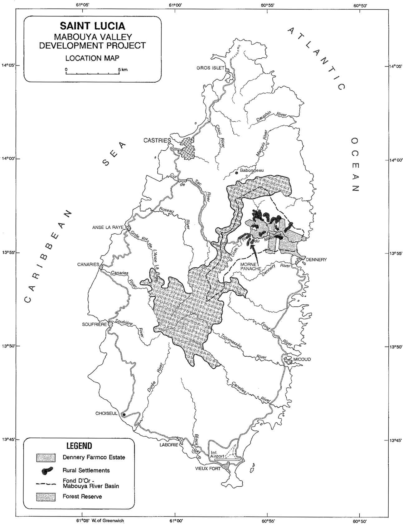
Following these studies the Government of Saint Lucia requested technical assistance from the OAS to design and implement a pilot project. This project would serve as a possible model of integrated resource management in a discrete locality. The Government, together with the OAS, chose the village of Morne Panache, in the Mabouya River Valley, Quarter of Dennery (Maps 1 and 2). The Project was instrumental in preparing the way for the National Land Cadastre and Survey and the Mabouya Valley Development Project.
Saint Lucia - Mabouya Valley development project - Location map
![]()
![]()
![]()
![]()