![]()
![]()
![]()
![]()
![]()
Introduction
Ecosystem structure and function
Conflict identification
Colonization: Pressures and problems
Directed occupation and authorized uses of the humid tropics
Land use capability
Agriculture
Forestry
Livestock management
Prior inhabitants and uses
Spontaneous migration
Monitoring
International development assistance agencies
Observations on political will
Bibliography
![]()
The development planning process designs strategies and activities to use, enhance or conserve both natural and economic goods and services. In big modern cities, economic goods and services almost completely replace the natural ones. On the other hand, in frontier areas like the Central Selva, natural goods and services play a relatively greater role. Shifts towards economic goods and services are the result of increased human activity designed to improve human quality of life. For example, development activities in "new areas" of the humid tropics are aimed at establishing farms and forest industries; building homes for greater numbers of people; growing food for expanding urban populations; promoting national defense and territorial sovereignty; and utilizing idle resources. Meeting these goals requires more economic goods and services.
In a simplified model of the process by which a nation seeks to fulfill these objectives, it first identifies "empty" territory within its humid tropics that has underutilized resources. It wishes to develop these resources to contribute to the socioeconomic well-being of the people who live in the area as well as those who will migrate there, and to benefit the nation as a whole. The government of that country then formulates national policies that guide migration, expenditure of funds and the use of technology. These policies may be adjusted by the support or opposition of international development assistance agencies (World Bank 1986).
Unfortunately, development efforts frequently fail due to such obstacles as inadequate support by centralized agencies and local institutions, poorly defined land tenure systems, lack of coordination among development sectors, and scarce information on the structure and function of social and natural systems. As the previous chapters often suggest, these same conditions are involved in creating the conflicts that have come to be known as "negative environmental impacts."
A more comprehensive model of the process identifies additional conditions and events that must be considered in the design and execution of development projects and programs. Chief among these are that, though sparsely settled, the humid tropics are seldom "empty"; that justifiable development activities allow uncontrolled access by farming and grazing practices not entirely appropriate over extensive areas; that the "richness" of tropical forests is one of the characteristics making tropical forest management so difficult; that any development activity will change ecosystem structure and function; and, that the appropriation of goods and services for the good of a society will create conflict within that same society. This chapter will make extensive comments on this model in the form of observations, guidelines, and recommendations that will help development planners in the humid tropics to overcome these and other problems.
Chapter 2 of this report described the process by which competition for the goods and services of an ecosystem can lead to conflict. This first set of guidelines attempts to show how to resolve many of these conflicts in the planning process, before they threaten the project's success.
1. Develop a regional conceptual model. Despite the scarcity of data about the humid tropics, an awareness of ecosystem structure and function during planning is possible. Seeing the region as an integrated whole is vitally important, and this requires a team who understands systems in general, who thinks in terms of relationships, and who can synthesize information from different disciplines (Moiling, 1978). Conceptual modeling of a region is a useful method in that it forces integrated thinking, and the process itself is as important as the final product. Using the method presented in Appendix A, a Preliminary National System Model of Peru (Figure 16-1) and a Regional System Model of the Central Selva (Figure 16-2) were developed so that anyone fully participating in the process can understand in some detail the major components and interactions.
2. Inventory goods and services. Classical natural resource inventory methods will continue to be used in development planning. In addition to these, there are additional methods that are more specific in the evaluation of what human beings may take and use from ecosystems. Table 16-1 is an extensive list of the goods and services that can be provided by the natural structure and function of ecosystems. Each planning effort must develop its own list, however, based on interviews with the people who live in, use, or have an interest in the ecosystem(s) under study. Planners should also recognize that exploitation of any good or service, however small or seemingly insignificant, proves that something there is of value to someone, to be used, enhanced, or protected. Tables 16-2 and 16-3 indicate the goods and services of humid tropical ecosystems which may need protection in order to be used.
3. Inventory natural hazards. The same characteristics of ecosystem structure and function which give rise to water, food, minerals and energy also create earthquakes, high winds, intense rain, flooding, erosion, and poisonous plants and animals (Table 16-4). Since hazardous natural phenomena restrict the development of human activity, the planning team must identify and describe them, and predict how they might threaten the project at hand.
FIGURE 16-1 - PRELIMINARY NATIONAL SYSTEMS MODEL OF PERU
FIGURE 16-2 - PRELIMINARY CENTRAL SELVA REGIONAL SYSTEMS MODEL
Table 16-1
NATURAL GOODS (RESOURCES) AND SERVICES
|
I. Goods/Products (Resources) | ||
|
|
1. Surface and ground water for drinking | |
|
|
2. Surface and ground water for industry | |
|
|
3. Surface and ground water for irrigation | |
|
|
4. Biomass for lumber | |
|
|
5. Biomass for firewood | |
|
|
6. Biomass for construction materials (posts, vigas, etc.) | |
|
|
7. Ornamental plants (indoor, landscaping, dry) | |
|
|
8. Vegetable fibers | |
|
|
9. Medicinal plants | |
|
|
10. Food for human consumption (fruits, chicle, honey, sap, shoots, etc.) | |
|
|
11. Plant chemical substance (dyes, stains, waxes, latex, gums, tannings, syrups, drugs, etc.) | |
|
|
12. Fish for human food (crustacians, finfish, mollusks) | |
|
|
13. Fertilizer (guano, other dung, fish meal) | |
|
|
14. Aquatic plants for human food (algas) | |
|
|
15. Aquatic precious/semiprecious materials (pearl, coral, conchas, mother of pearl) | |
|
|
16. Materials for artisan work (rock, wood for carving, fibers for basketmaking, etc.) | |
|
|
17. Metallic minerals (bauxite, ores, nuggets, etc.) | |
|
|
18. Non metallic minerals | |
|
|
19. Construction materials (sands, clay, cinders, cement, gravel, rocks, marble) | |
|
|
20. Food materials (salt) | |
|
|
21. Mineral nutrients (phosphorus) | |
|
|
22. Material for mineral dyes, glazes | |
|
|
23. Hides, leather, skins | |
|
|
24. Other animal materials (bones, feathers, tusks, teeth, claws, butterflies) | |
|
|
25. Other vegetation materials (seeds, pods) | |
|
|
26. Live fish (ornamental, aquaria) | |
|
|
27. Live animals for pets, zoos | |
|
|
28. Live animals for research (medical, other) | |
|
|
29. Fossil fuels (oil, gas, coal) | |
|
|
30. Other fuels (peat, other organic matter dung - biomass) | |
|
|
31. Livestock forage | |
|
|
32. Food for livestock (fish meal) | |
|
|
33. Pulpwood | |
|
II. Ecosystem Maintenance Services | ||
|
|
1. Nutrient cycling | |
|
|
2. Nutrient storage | |
|
|
3. Nutrient distribution | |
|
|
4. Photosynthesis-Respiration (biomass-succession) | |
|
|
5. Population control (predator/prey) | |
|
|
6. Flooding | |
|
|
7. Sediment transport | |
|
|
8. Habitat for local finfish | |
|
|
|
- feeding |
|
|
|
- breeding |
|
|
|
- nursery |
|
|
|
- resting (refuge) |
|
|
9. Habitat for migrating finfish | |
|
|
|
- feeding (including transient food source) |
|
|
|
- breeding |
|
|
|
- nursery |
|
|
|
- resting (refuge) |
|
|
|
- migration route |
|
|
10. Habitat for Crustacea | |
|
|
|
- feeding |
|
|
|
- breeding |
|
|
|
- nursery |
|
|
|
- resting (refuge) |
|
|
|
- migration route |
|
|
11. Habitat for mollusks | |
|
|
|
- feeding (including transient food source) |
|
|
|
- breeding |
|
|
12. Buffering | |
|
III. Non-tangible Goods and Services | ||
|
|
1. Windbrake | |
|
|
2. Shade | |
|
|
3. Recreation use of water (swimming, boating, waterskiing, sailing) | |
|
|
4. Zones for scenic tourism | |
|
|
5. Zones for recreation tourism | |
|
|
6. Zones for scientific tourism | |
|
|
7. Scientific values | |
|
|
8. Spiritual values | |
|
|
9. Historical values | |
|
|
10. Cultural values | |
|
|
11. Sport hunting and fishing | |
|
|
12. Early warning system | |
|
|
13. Moisture modification (humidity) | |
|
|
14. Temperature modification | |
|
|
15. U.V. filtration | |
|
|
16. Endangered species (fauna) | |
|
|
17. Endangered species (flora) | |
|
|
18. Gene resource (fauna) | |
|
|
19. Gene resource (flora) | |
|
IV. Economic Services | ||
|
|
1. Hydroelectric power source | |
|
|
2. Other energy sources (wind, sun, tides) | |
|
|
3. Dilution of contaminants | |
|
|
4. Decomposition of contaminants | |
|
|
5. Oxidation of contaminants | |
|
|
6. Transportation of contaminants | |
|
|
7. Airshed (dilution of air contaminants) | |
|
|
8. Erosion control | |
|
|
9. Sediment control | |
|
|
10. Flood control | |
|
|
11. Groundwater recharge | |
|
|
12. Space for urban, industrial, agriculture, occupation, roadways, canals, airports, waste storage | |
|
|
13. Physical support for plants | |
|
|
14. Pollination | |
Table 16-2
NATURAL GOODS PRODUCED BY PROTECTED AREAS IN THE AMERICAN HUMID TROPICSa and b
|
Goods |
National Parks |
National Reserves |
National Sanctuaries |
Historic Sanctuaries |
Protective Forest |
Wildlife Areas |
Reserved Zones |
Native Reserves |
|
Water |
VI |
VI |
S |
NS |
VI |
S |
VI |
NS |
|
Genetic bank (Flora) |
VI |
I |
I |
NS |
I |
S |
VI |
NS |
|
Genetic bank (Fauna) |
VI |
I |
I |
NS |
I |
I |
VI |
NS |
|
Goods from fauna |
|
VI |
|
|
I |
VI |
|
VI |
|
Goods from fishing |
|
I |
|
|
S |
NS |
|
VI |
|
Non-lumber vegetative goods |
|
|
|
|
VI |
|
|
|
|
Lumber vegetative goods |
|
|
|
|
S |
|
|
S |
a. The Roman numbers (I-VIII) indicate management categories adapted by IUCN (1978).
b. VI: Very Important: I: Important: S: Significant: NS: Not Significant.
Conflicts arise during the development process either from open competition for goods and services or as a result of human activities which change the quality and quantity mix of available goods and services. There are several ways that such potential conflicts can be identified during planning.
1. Use an environmental management advisor. The environmental management advisor undertakes studies and evaluations that help coordinate the planning process, and which help identify significant interrelations within the region being planned.
2. Coordinate to reduce potential conflicts. If formulation of sectoral projects is well coordinated with other sectors, many potential conflicts will never occur. Coordination will, of course, require that all planners and other team members work together to allow an exchange of ideas and to insure that consultants are aware that the work of sectors other than their own may be relevant to the success of the project.
3. Review the conceptual model. Since conflicts arise between two or more sectors only if development activities are somehow related, review of the conceptual model described above is helpful. If done with the help of all relevant sectors, lines of complicated interactions will emerge. The exercise enables representatives of the many disciplines and sectors to understand where their work fits in the overall scheme; it enables team members to identify information gaps and promising areas of study; it enables team members to foresee the ramifications of each activity and, because of this, to identify potential conflicts early in the planning process.
4. Analyze natural and economic goods and services. A third method is to list the goods and services in the subsystems of the region being studied (Table 16-1) so that each of the goods and services can then be assigned to individual sectors.1 Since any component of a system is linked to others in that system, use, enhancement, or conservation of the component will influence the availability and/or quality of other goods and services. Once sectors that are interested in the same good or service from the same or linked subsystems are identified, potential conflicts are also known.
1. For more information on this method see Case Study number IV of "Integrated Regional Development Planning: Guidelines and Case Studies from An OAS Experience". 1984. General Secretariat of the Organization of American States. Washington, D.C.
A general example can be seen from Table 16-5 where ecosystem "a" has land for locating industry, agriculture, and livestock production, as well as for wildlife habitat. It would be difficult, if not impossible, to undertake activities which would meet all four of these objectives on the same piece of land at the same time. Consequently any project using "land" would be in conflict with the other projects. Likewise, subsystem "b" has groundwater that can be used for irrigation and domestic consumption. In this case, both uses are possible depending on the quantity of groundwater actually available and the demand of each sector. Subsystem "b" has also land for industry. However, since both land and groundwater are in the same subsystem, the groundwater may be contaminated by industrial wastes, and made unfit for domestic use. On the other hand, use of groundwater for domestic purposes will require either that the industry be sited somewhere else or, that it incorporate additional technology to avoid groundwater contamination. Here conflicts have been identified and a decision in favor of either side will negatively affect the other party.
Table 16-3
NATURAL SERVICES PRODUCED BY PROTECTED AREAS IN THE AMERICAN HUMID TROPICSa
|
Servicesb |
National Parks |
National Reserves |
National Sanctuaries |
Historic Sanctuaries |
Protection Forests |
Wildlife Refuge |
Reserved Areas |
Common Reserves |
|
Recycling of Atmospheric Contaminants |
VI |
VI |
S |
NS |
VI |
I |
I |
NS |
|
Maintenance of the Local Precipitation Regime |
VI |
VI |
NS |
NS |
VI |
S |
I |
NS |
|
Buffering of Local Climate |
VI |
VI |
NS |
NS |
VI |
S |
I |
NS |
|
Regulations of the Water Regime |
VI |
VI |
NS |
NS |
VI |
S |
I |
NS |
|
Maintenance of Supply of Quality Water |
VI |
VI |
NS |
NS |
VI |
S |
I |
S |
|
Soil Conservation |
VI |
I |
NS |
NS |
VI |
S |
I |
S |
|
Protection from Landslides, Floods and Other Hazards |
VI |
I |
NS |
NS |
VI |
S |
I |
S |
|
Maintenance of Genetic Diversity |
VI |
I |
VI |
NS |
I |
S |
I |
NS |
|
Maintenance of Natural Diversity |
VI |
I |
VI |
NS |
I |
S |
I |
NS |
|
Reservoir for Species which Offer Biological Control of Plagues |
VI |
I |
I |
NS |
I |
I |
I |
S |
|
Reserve for Species of Interest to Science |
VI |
I |
VI |
NS |
I |
I |
I |
NS |
|
Reserve for Species of Interest for Domestication |
VI |
VI |
S |
NS |
I |
I |
I |
NS |
|
Genetic Bank for Future Improvement of Domesticated Species |
VI |
VI |
S |
NS |
I |
I |
I |
NS |
|
Scenic Beauty |
VI |
S |
I |
S |
I |
S |
I |
NS |
|
Area for Hunting |
- |
VI |
- |
- |
VI |
VI |
- |
VI |
|
Area for Fishing |
- |
VI |
- |
- |
I |
VI |
- |
VI |
|
Area for other Recreation |
VI |
I |
S |
I |
VI |
I |
S |
S |
|
Area for Tourism |
VI |
S |
I |
I |
S |
I |
S |
NS |
|
Conservation of Natural and Historic Scenery |
I |
NS |
- |
VI |
NS |
- |
- |
- |
|
Conservation of Cultural Patrimony |
I |
S |
VI |
S |
S |
S |
S |
- |
a. The Roman numerals (I-VIII) indicate equivalent management categories adopted for IUCN (1978).b. VI: Very Important, I: Important, S: Significant, NS: Not Significant, -: Not Applicable.
Table 16-4
NATURAL HAZARDOUS PHENOMENA
|
1. Diseases and plagues (virus, bacteria, flukes, parasites, fungi, etc.) |
Table 16-5
EXAMPLES OF NATURAL GOODS AND SERVICES PROVIDED BY TWO HYPOTHETIC ECOSYSTEMS AND THEIR USE IN CONFLICT IDENTIFICATION
|
|
Ecosystem |
|
|
a |
b |
|
|
Land for Agriculture |
X |
|
|
Land for Industry |
X |
X |
|
Land for Grazing |
X |
|
|
Wildlife Habitat |
X |
|
|
Underground Water for Irrigation |
|
X |
|
Underground Water for Domestic Use |
|
X |
5. Use an activity matrix. An activity matrix requires a fairly complete understanding of the different sectoral activities as well as in-depth discussions between representatives of the sectors or interests involved (there may be more than two). In the example given in Table 16-6, the activities underway or being proposed are:
a. Rice culture, including land transformation and preparation; seeding, cultivating and pest control; irrigation and drainage including the construction of canals, dikes and ditches; harvest and marketing.b. Vegetable culture, including land transformation, planting, cultivating, pest control, irrigation and drainage; harvest and marketing.
c. Livestock production, including transformation of new land and replacement of other uses by livestock production for beef and dairy cattle, swine and poultry.
d. Forestry, includes the cutting and removal of trees as well as the building of access roads and trails for these purposes. In this case, it does not include any silvicultural treatment or management.
The matrix is shown on Table 16-6 where the cells are numbered to indicate the conflicts discussed below. The conflicts that can be identified on the basis of this matrix are between:
(1) Rice culture and rice culture. The expansion of irrigated rice area will create additional competition for available irrigation water; rice growing will bring with it the problems of any monoculture; and long-term rice culture on the same land can compact soils - especially if heavy machinery is used.(2) Rice culture and vegetable culture. The aerial spraying of pesticides in rice production may contaminate vegetable crops or reduce vegetable production if the wrong herbicides are used.
(3) Rice culture and livestock production. Competition for the same land.
(4) Rice culture and forestry. Competition for the same land. Land clearing by fire may burn nearby forests.
(5) Vegetable culture and rice culture. If vegetables are not to be killed or contaminated by the pesticides used in rice culture, changes in the timing of spraying, method of spraying, kind of pesticide, etc. would have to be instituted.
(6) Horticulture and forestry. See number 4.
(7) Livestock production and rice culture. Competition for the same land. If grazing does occur on rice fields, compaction of soils may occur and canal borders and dikes may be broken down.
(8) Livestock production and forestry. See number 4.
(9) Forestry and rice culture. Competition for the same land. Forests serve as refuge areas for noxious fauna.
(10) Forestry and horticulture. See number 9.
(11) Forestry and livestock production. See number 9.
(12) Forestry and forestry. Forest exploitation without management destroys the possibilities of sustained yield forestry. The creation of access allows migrants to enter and utilize the forest ecosystem in ways that are not compatible with sustained yield forestry.
Table 16-6
INTERSECTORAL MATRIX IDENTIFYING POTENTIAL CONFLICTS BETWEEN SECTORAL ACTIVITIES
|
|
Rice Cultivation |
Vegetable Cultivation |
Livestock Production |
Forestry |
|
Rice Cultivation |
1 |
2 |
3 |
4 |
|
Vegetable Cultivation |
5 |
|
|
6 |
|
Livestock Production |
7 |
|
|
8 |
|
Forestry |
9 |
10 |
11 |
12 |
A number of actual and potential conflicts in the Central Selva can be identified based on this concept (some of these have been examined throughout this report). For example, Table 16-7 indicates conflicts generated between the creation of protected areas and the activities of other sectors. Figure 16-3 identifies conflicts between the fisheries sector and the others, while Figure 16-4 presents those that occur between the other sectors and wildlife.
Table 16-7
PRINCIPAL CONFLICTS BETWEEN THE PROTECTION OF AREASa AND OTHER DEVELOPMENT ACTIVITIES IN THE AMERICAN HUMID TROPICS
|
Conflictsb |
National Parks |
National Reserves |
National Sanctuaries |
Historic Sanctuaries |
Protection Forests |
Wildlife Refuge |
Reserved Areas |
Common Reserves |
|
Restriction of Agricultural Expansion |
VI |
VI |
SN |
NS |
NS |
S |
VI |
NS |
|
Restriction of Forest Exploitation |
VI |
VI |
NS |
NS |
NS |
S |
VI |
NS |
|
Hunting Restrictions |
VI |
- |
I |
NS |
- |
- |
VI |
- |
|
Fishing Restrictions |
S |
- |
NS |
- |
- |
- |
I |
- |
|
Restrictions on Energy Use and Transmission |
VI |
I |
VI |
VI |
I |
S |
VI |
S |
|
Restrictions on Mining |
VI |
I |
VI |
VI |
I |
S |
VI |
S |
|
Restrictions on Petroleum Development |
VI |
I |
VI |
VI |
NS |
S |
VI |
S |
|
Reservoir for Agriculture, Forest and Range Pests |
VI |
VI |
S |
NS |
VI |
S |
VI |
NS |
|
Reservoir for Diseases of Livestock and Humans |
VI |
VI |
S |
NS |
VI |
I |
VI |
S |
|
Refuge for Species that are Dangerous for Humans and Livestock |
VI |
VI |
NS |
NS |
VI |
VI |
VI |
NS |
|
Restriction of Urban Expansion |
VI |
VI |
VI |
VI |
S |
S |
VI |
S |
|
Restrictions on Road Development |
I |
S |
VI |
VI |
- |
I |
I |
I |
|
Restrictions on Certain Kinds of Tourist Development |
VI |
I |
VI |
VI |
- |
I |
VI |
- |
|
Restrictions on Use of Certain Technologies Outside of the Protected Area |
I |
S |
VI |
I |
S |
I |
I |
S |
a. The Roman numerals (I-VIII) indicate the management categories adopted by IUCN (1978).
b. VI: Very Important; I: Important: S: Significant: NS: Non Significant; -: Not Applicable.
Figure 16-4 - PRINCIPAL CONFLICTS BETWEEN WILDLIFE AND ACTIVITIES TO USE OTHER RESOURCES
6. Distinguish between real and apparent conflicts. Some "conflicts" arise because objectives and methods are not clear to one or both of the parties. Their resolution is easiest if information is shared and if issues are clarified. Other conflicts easily resolved are those where the parties encounter a common problem as they attempt to reach different compatible objectives, as illustrated in Figure 16-5. A third kind of conflict is "conflict of interest" where the objectives and the means to meet them are opposed. Here the techniques of third party arbitration are the most valuable.
And, to show that not all relationships are conflictive, Figure 16-6 identifies relationships between aquatic life and aquaculture on one hand and other development activities on the other, which are supportive, rather than conflictive.
The mere existence of sparsely occupied territories in humid tropical areas of a country is not sufficient to create pressures for their further development: Suriname's small population is concentrated almost totally along the coast for example, and is not in need of more space. Rather pressures to "develop and modernize" arise in countries with high unemployment, large economically marginal populations, unbalanced land tenure, and failing agriculture programs, combined with a need to secure national borders. Guidelines which respond to these pressures are required if progress is to be made.
Figure 16-5 - EXAMPLE OF A "COMMON PROBLEM" CONFLICT

Several things can be done to insure successful colonization.
1. Review and adjust policies at the national level to assure that colonists represent cohesive groups who want to migrate. Pressures that make life difficult in new colonies are great enough without having to deal with confrontations resulting from dissimilar beliefs, different economic status within the groups, and the need to search for, and approve of, new leadership.
2. Recruit and select migrants from areas having climatic, edaphic, and topographic conditions similar to those of their final destination. New efforts at development in the humid tropics often run into problems with colonization. The ingredients for a successful colonization project include a group of people who form a tightly knit social unit, who are experienced in living and working in ecosystems similar to those of the new colony, and who have a strong desire to relocate. Data also suggest that the most successful colonies consist of people who have no options: they can neither return to where they came from nor move on to another area (Nelson, 1973; Bridger, 1980).
3. Institutionalize policies that give the sectoral agencies most closely allied to the colonization effort the resources they need to carry through the new plans. Continue this technical and political support until the colony can manage on its own.
There are two major advantages to this model. Overall coordination is assured as long as an institution exists that remains in control; and which can provide financial and technical resources without continually competing for scarce funding and personnel through the normal budget process. Disadvantages are, clearly, that any changes in overall national priorities can nullify advances if support is withdrawn before the colonies are consolidated.
4. Undertake regional equalization. Regionalization looks toward allocation of development resources and efforts throughout the nation which will reduce pressures to migrate as well as to properly guide development in areas targeted for colonization.
5. Establish regional development authorities (such as the TVA in the United States and the CVC in Colombia) to defend local interests in national budgeting decisions, to assure that their share of social services and development projects are forthcoming and to undertake development activities on their own. However, the creation of regional authorities is not easy; pressures for more centralization are great and competition between development sectors and between the various political units operating in a region are always a threat.
"Directed occupation" is defined as the consolidation of human settlements through planning and project execution by public agencies or private organizations. "Spontaneous" colonization is included if it results from the creation of access routes where colonization was anticipated but not funded. "Authorized uses" refers to the open or implied permission of a government to allow appropriation of the goods and services available from an area.
If the decisions as to where and how colonization is to take place are poorly made, development activities based on those decisions have little chance of success. To make the number of colonists, the activities of development and the exploitation of systems goods and service compatible with what the system offers requires formulation of policy, financing, and available appropriate technology. Policy guidelines for a large variety of development activities in the humid tropics include land use capability studies and the application of appropriate agriculture, forestry, and livestock management practices.
Much of spatial development planning is based on an analysis of "land use capability" - the suitability of an area for any use that will not damage the resource being used. Land use capability studies place land in a number of classes dependent on a survey of the soils and related features of the area with subsequent interpretation of this information according to its future use and management.
1. Include cost and availability of technology in decisions on land use capability. Table 16-8 presents the results of three different land use capability studies by three different groups in the same area of the Central Selva. Despite the fact that land use capability studies have long been used, they are strongly influenced by the opinion of the technician, and serious errors can be made if all the assumptions that went into the classification are not known. In the case of Table 16-8, the differences are apparently the result of different ideas on what land use is best under three dissimilar scenarios of available technology. Here study "B" appears to be production oriented, requiring heavy use of fertilizer and other inputs. Study "C" looks toward conservation, in the belief that although the technology anticipated in study "A" exists, its use in this area of the Peruvian Selva will be limited by funding and logistical constraints. Land use capability is dependent on both the inherent characteristics of the landscape and a certain level of technology. The figures in Table 16-8 can only be understood if the technology being considered is described. And, information on land use capability can only be used for development purposes if the anticipated technology is supplied. For example settlement schemes based on either study "A" or on study "B" will require much more credit, extension services, and other inputs than will a scheme based on study "C." On the other hand, "forest protection" also requires that a certain level of technology (guards, patrol vehicles, sensitization of incoming population with reference to the values of forest protection) be present if the project is to be successfully implemented. It is interesting to note that adherence to any of the three strategies in Table 16-8 will cause the destruction of the humid tropical ecosystems in question if the technology on which the alternatives are based is not forthcoming.
Table 16-8
THREE MAJOR LAND USE CAPABILITY CLASSIFICATIONS OF THE SAME PROJECT IN THE PALCAZU VALLEY OF THE CENTRAL SELVA
|
Land Use Capability |
% of Total Land Use |
||
|
Study A |
Study B |
Study C |
|
|
Clean tilled crops |
16,8 |
9.4 |
7.5 |
|
Permanent crops |
5.3 |
32.4 |
14.4 |
|
Pasture |
27.8 |
53.1 |
13.3 |
|
Forest utilization |
36.7 |
4.1 |
46.2 |
|
Forest protection |
13.4 |
1.0 |
18.6 |
|
Total |
100.0 |
100.0 |
100.0 |
Source: ONERN, 1982; Villachica, 1981; Tosi, 1981.
2. Base land use decisions on realistic evaluations of the potential benefits and risks of proposed development, as well as on actual land use, land tenancy, and migration patterns. Development controversies in the humid tropics are focused on the availability of long-term sustained production; the appropriate level and kind of technology for managing tropical agroecosystems; and the suitability of the humid tropics for specific economic activities such as extensive livestock or oil palm production. Planners need to exercise extreme caution in using available data since much of it can be misinterpreted or interpreted in conflicting ways.
For example, the U.S. Soil Conservation Service land capability classification was developed for temperate regions but it has often been applied to tropical regions without sufficient consideration of the region's potential for soil erosion and nutrient leaching. As a result, developers in the humid tropics have designed agricultural production systems based on overly optimistic potential land use and agricultural credit and project funding encourages inefficient land use, increased clearing of forest lands and minimal use of natural goods and services. Appropriate land classification systems that are designed for use in the humid tropics include the soil fertility capability classification (Boul et al, 1975) and the Life Zone System (Holdridge, 1967), which Peru has now adopted as the official land classification system.
The problems and promise of movement of the agriculture frontier into the humid tropics are well known (Chapter 4 and 7). Large areas of the humid tropics now have access to rudimentary transportation, infrastructure and markets. However, many of these lands have been so over exploited that they have been abandoned, making both infrastructure and market access useless.
1. Develop sustained yield management for humid tropic ecosystems. Such lands are becoming accessible and new markets are becoming available. Planners should design projects that include the following:
a. Plantings representative of home gardens where 10-40 different varieties of fruits are grown. Size of planting area can be adjusted to fit physical and economic characteristics of the available space;b. selected seeds and propagation nurseries;
c. cultural practices already in use, i.e., weeding; little or no use of fertilizer, pesticides or fungicides; pruning; and intercropping;
d. continuous income based on the use of species that do not require plant harvest; and
e. continuous harvest based on marketing and processing that are integrated with planting schedules and varietal selection.
2. Evaluate and include native fruits as a component of socio-economic development in the humid tropics. The native fruits of the Amazon represent a natural, rational, balanced, and renewable use of natural resources where the nutrition potential, especially vitamins, is proportionately higher than the other fruits (Table 16-9).
3. Encourage systems of sustained agriculture production. See Tables 16-10, and 16-11 for examples. Advantages of annual cropping and permanent or mixed cropping (agroforestry) are compared in Table 16-12. Different crops and neglected economic plants such as native tropical fruits and palms can be used (Table 16-13). Raising soil fertility levels, especially on acid infertile soils, can sometimes be cost effective. Management practices should strive to keep the ground covered by using mixed or sequential cropping when annual crop production is necessary. Often tree crops and/or pastures can be incorporated into the system after 1-2 years of continuous cropping of annuals, producing a tree canopy that replaces a crop canopy, provides soil protection and reduces loss of nutrients on a long-term basis.
4. Use forest clearing techniques for agriculture that avoid soil compaction and that maintain water percolation and topsoil conservation, such as manual felling and burning rather than clearing by heavy machinery. The following guidelines should be followed when forests are to be cleared:
a. Maintain interspersed stands of natural forest on cleared lands to form an agriculture-forest mosaic.b. Use intensively managed annual crops on fertile alluvial soils that are in little danger of flooding or, if floodable, adjust the cropping cycle to the flood cycle. Although fertilizers will be required in such areas, the level of use will be minimal.
5. Examine the feasibility of rural development based on the management capabilities of colonists and native communities; institutional constraints of production and marketing; and, the maximum debt load a farmer can withstand. The success of producing annual crops depends on fluctuating markets and unpredictable growing conditions. Consequently, colonists, as well as native communities with capital, establish permanent crops soon after forest clearing. Permanent crops require relatively little maintenance, provide a long-term steady income, and increase land values. On the other hand, annual crops are less expensive to establish and can provide quick returns. However, if yields are low or the crops destroyed, especially in the initial stages of colonization, there is little reserve capital available for land clearing, seed, and labor expenses for the next cycle. If the entire farm income is continuously dependent on annual crops, it is quite easy to fall into a cycle of financial debt that limits further investment in permanent production systems.
Table 16-9
NATIVE FRUITS EXCEPTIONALLY HIGH IN NUTRITIONa
|
Fruit |
Nutritional Aspect |
Proportion higher than average fruit |
|
Aguaje (Mauritia flexuosa) |
Vitamin A |
16 x |
|
Vitamin B |
2 x |
|
|
Calories |
5 x |
|
|
Calcium |
3 x |
|
|
Pejibaye (Guilielma gasipaes) |
Vitamin B2 |
3.5 x |
|
Protein |
2 x |
|
|
Carbohydrates |
3 x |
|
|
Calories |
3 x |
|
|
Cocona (Solarium sessilflorum) |
Niacin, Iron |
4 x |
|
Passion fruit (Passiflora edulis) |
Niacin |
4 x |
|
Lucuma (Lucuma obovata) |
Niacin |
3 x |
|
Camu-camu (Myrciaria paraensis) |
Vitamin C |
121 x |
a. See also NAS (1975) and NRC (1982) appendices 7, 8 and 9 for extensive lists of species native to the humid tropics.
Table 16-10
ACTUAL AND POTENTIAL AGRICULTURAL PRODUCTION SYSTEMS IN THE AMAZON BASIN
|
Agricultural Production |
Crops |
Production Systems |
|
1. Annual crops |
Corn |
Subsistence agriculture crop production alternated with secondary forest cover (shifting field agriculture) |
|
2. Semi-permanent crops |
Banana |
|
|
3. Backyard orchards |
Fruit bearing trees having nutritious value; avocado, bread fruit, pejiyava palm |
Sedentary agriculturea |
|
4. Perennial crops Coffee |
Cacao |
|
|
5. Cattle Production |
Forage |
Commercial agricultureb |
|
6. Plantations |
Production systems |
|
|
1. Forest Trees |
1. Homogeneous plantations |
Implemente by industry or governmental agencies. Implemented by the agricultural sector in multi-strata production systemsa |
a. Suitable for multi-strata production systems.b. Taungya is distinguished from agroforestry systems by the fact that the tree component is only associated with annual or biannual crops during the establishment phase. After one or two years the farmer leaves the planting site permanently and the responsible institution takes charge of it. In agroforestry systems, to the contrary, the farmers are continuously managing the association and, needless to say, are the beneficiaries of the timber production.
Source: Peck, 1977.
6. Encourage conversion from shifting to permanent agriculture and design agricultural credit for medium-term (4-10 years) rather than for short term (1 year) before repayment begins; adjust the grace period and credit to specific realistic conditions of crop or animal production.
Table 16-11
LIST OF CROPS SUITABLE FOR THE HUMID TROPICS
|
Tropical Crops |
Best Growing Conditions |
Environmental Limitations |
|
Annual Cropsa |
Adequate nutrients, and water to take advantage of short-growth period |
Pest and weed competition reduces yields, dry season needed for harvest and drying |
|
Sugar cane |
High water use and fertile soils |
Without marked dry season harvest is difficult and sugar content low |
|
Root Crops |
High requirements for potassium |
Continuous harvest not limited by wet climate |
|
Tree Crops |
Distinct dry-wet season favors flowering and fruit set |
Extremely humid conditions or evenly distributed rainfall causes aborted flowers with little or no fruit set |
|
Citrus |
Proper soil conditions to maintain well drained root zone |
Excessively wet or cool temperatures slow growth |
|
Coffee |
Cool temperature, fertile soils |
Change in soil moisture levels induces flowering |
|
Cacao |
Fertile soils, sufficient water |
Excessive precipitation results in lower fruit set |
|
Tea |
Acid soils, cool temperatures |
|
|
Avocado |
|
Susceptible to poor drainage conditions |
|
Papaya |
|
Virus and mosaic limits length of production |
|
Coconuts |
|
No tolerant of heavy textured soils |
|
African Oil Palm |
Fertile, well drained soil, high moisture requirement |
High yields required minimum hours of sunlight |
|
Others |
Acid soils for high fruit acidity |
|
|
Bananas/Plantains |
Require fertile soils and even distribution of water |
Susceptible to poor drainage |
a. Personal communication with Carlos Robles, soils specialist, ONERN, September 1982.
Table 16-12
A COMPARISON OF ANNUAL CROPPING AND SUSTAINED YIELD SYSTEMS IN THE HUMID TROPICS
|
Characteristics |
Intensive Annual Cropping System |
Sustained Yield Agriculture |
|
1. Net Production |
High - requires heavy fossil fuel inputs that are expensive. |
Moderate - but sustainable at low costs. |
|
2. Dietary Contribution |
Low - complete diet dependent upon outside sources of food at considerable cost. |
High - complete energy, vitamin, and protein from a variety of cultigens and animal sources. |
|
3. Species Diversity |
Low - generally devoted to a single plant species or animal breed. |
High - both in total and number of individuals of each species. |
|
4. Space Utilization |
Poor - bare soil unoccupied by photo-synthetic material due to simple crop. direct and diffuse light. |
Excellent - three dimensional space largely filled by plants adapted |
|
5. Inherent Stability |
Low - dependent upon the fossil fuel inputs for fertilizer, pesticide and mechanical control of outbreaks of host-specific pests and diseases. forest ecosystems. |
High - competitive exclusion of weeds by diverse food plants, avoidance of pest epidemics through diversity of host plants. Analogous to natural |
|
6. Nutrient Cycles |
Open - large proportion of all nutrients applied to crops is lost to leaching and crop export. |
Closed - minerals trapped by early successional annuals and perennial crop plants. Nutrient cycling mechanisms located above ground living biomass. |
|
7. Economic Stability |
"Boom or Bust" - with optimal conditions and large expenditures of fossil fuel inputs, high yields and profits are possible. Yields are vulnerable to market fluctuations other environmental stress beyond the farmer's control. Labor requirements highly seasonal. Tendency for mechanization to replace human labor. |
High - variety of food produced for region or national consumption assures a market for some crops. Flexibility to switch plant energy flow from and direct marketing to increased animal production is practical. Low capital investment makes subsistence on a quality diet feasible. Harvest can be programmed throughout the year, as can labor requirement. |
|
8. Social Viability |
Volatile - economics of scale tend to concentrate management decisions, production and profit in the control of a socioeconomic |
Adaptable - emphasis on the direct involvement of small to medium size farmers in viable systems of sustained |
Permanent crops such as plantains can be harvested within a year after planting, whereas cacao, coffee, or fruit trees may take as long as 3-5 years to reach a first harvest and even longer to reach economic breakeven levels. A successful agroforestry system combines cropping of annuals and perennials that provides a short-term source of income (annuals), imitates the natural forest succession, minimizes labor and energy inputs for pest control, and establishes long-term production (perennials) at relative low initial cost.
7. Evaluate current national agricultural research, extension, and training priorities to see if they are in line with actual farm problems in the humid tropics.
In Peru many of the priorities are dedicated to rice, livestock, and potatoes on the coast and sierra only. As a result, researchers, extension agents, and teachers are ill-prepared to plan projects in the humid tropics because they understand neither the problems of tropical agriculture nor problems among the sectors.
8. Encourage communication and information exchange with national and international agricultural institutions (CIAT, CATIE, REDINAA) and donor agencies in order to avoid duplication of effort or repetition of past mistakes.
9. Exercise caution when extrapolating results of research from one particular site of the humid tropics to the entire humid tropics and implement crop and animal production systems on real farms. Soil characteristics of the Tulumayo Experiment Station near Tingo María are excellent, but not representative of large areas of potential farmland being considered for development.
10. Be sure that research priorities in tropical agriculture are compatible with development needs and criteria for the humid tropics. Just as planners need guidance from scientists, researchers need guidance from developers. Cost/benefit evaluations of livestock production as compared with permanent crops, forestry, or annual crops are needed; the cost of clearing new lands as compared to establishing permanent agriculture on degraded or abandoned lands needs to be determined.
Experience in the management of native forests in the American humid tropics on a sustained basis is scarce. As a result, most forest management plans for these areas are theoretical or experimental and require a certain degree of flexibility so as not to overly commit energy and resources to management schemes that may not work.
Table 16-13
TREE CROPS SUITABLE FOR PERMANENT AGRICULTURE
|
Common Name |
Scientific Name |
|
Native Fruits | |
|
Bread fruit |
Artocarpus sp. |
|
Lucuma |
Lucuma obovata |
|
Guayabano |
Annona muracata |
|
Ubos |
Spondias lutea |
|
Taperiba |
Spondias dulcis |
|
Huito |
Genipa americana |
|
Umari |
Poraqueiba paraensis |
|
Uvilla |
Paurouma ceropiaefolia |
|
Cocona |
Solanum sessilflorum |
|
Passion fruit, Granadilla |
Passiflora edulis |
|
Araza fruit |
Eugenia stipitala |
|
Gumba |
Inga edulis |
|
Guayaba |
Psidium guajava |
|
Camu-camu |
Myrciaria paraensis |
|
Palms | |
|
Huasai |
Euterpe edulis |
|
Chonta, pijuayo, pejibaye |
Guilielma gasipaes |
|
Aguaje |
Mauritia flexuosa |
|
Ungurahui |
Jessenia batatua |
In general there are two basic alternatives in managing humid tropical forests: management of pure forests and management of forests associated with some other activity.
1. Apply pure forest management in lands designated as productive forest. Here the sole objective is to harvest timber and other forest products and is not associated with agriculture or livestock production. This type of management incorporates methods which clear-cut a forest of all trees and reforests the area with native or exotic species. Although technically easy to manage and despite high and homogeneous production per hectare, there are some disadvantages: the initial harvesting and planting costs are very high; the risk from pests and diseases is great and wood not able to be used immediately is lost.
2. Use natural forest management methods where natural forest conditions are required. Such methods are used to obtain maximum production without significantly modifying the forest's floristic composition over the long term. Managing natural regeneration focuses on selecting the most desirable wood-producing species and on treating them to encourage regeneration. Improving natural regeneration may involve planting commercially valuable species of proven growth capacity on small parcels. The approach is directed toward exploiting the forest's natural capacity for self regeneration, and the original ecosystem is not significantly modified. Further, costs are relatively low, and, if regeneration is successful, the forest can be exploited on a sustained yield basis. The disadvantages are that the final production per hectare is relatively low and that it requires a high degree of technical information and preliminary research, both of which are scarce.
3. Use associated forest management on land which has forest production potential, but which is being used for agriculture and livestock production. The goal is to reestablish forest land use where necessary by supplementing agriculture and livestock with forest production.
The potential value of this management method can easily be seen. More than 800,000 hectares have been cleared in the Central Selva to establish small agricultural and livestock operations. Only 25 percent of this land, however, is presently being used; 600,000 hectares are abandoned. This land can be profitably incorporated into associated forest management efforts, along with the 200,000 hectares already being exploited for agriculture and livestock. This system can also be applied to lands before they are abandoned.
Throughout the forested regions of the humid tropics only a small percentage of land is suitable for agriculture, and this land is being subjected to significant demographic pressure. As people's principal activities always include agriculture and livestock production, some forested land will have to be given over to these ends. The associated forest management alternative is suitable because it avoids massive forest destruction and, at the same time, allows both semi-intensive forest production and agriculture and livestock operations - if they focus on permanent crops.
Associated forest production can integrate forest exploitation and agriculture and livestock in both space and time. Spatial integration is achieved by growing forest and agricultural products at the same time; time integration occurs when agricultural and forest products are grown at different times on a rotational basis.
4. Use spatial integration of agriculture and forestry activities when possible. This alternative begins with a climax forest being subjected to semi-intensive harvesting. A remnant of the cut-over forest is left alone, and natural regeneration and adult seed trees of valuable species are nurtured. Later, the land will be used for a forest plantation or for permanent or temporary cultivation of such crops as cacao, coffee, bananas, acheote, and native fruits such as pineapples and pacae (Inga sp.) and planting native fruit trees - many of which are used by the indigenous peoples of the Central Selva (Table 16-13).
When trees are exploited for fruit, latex, resins, and other products besides wood, this system can be permanent. If, however, trees are to be harvested for wood, rotational planting must be precise so that forest management and timber harvest do not damage agricultural crops and non-wood forest products. In some cases, depending on the land, light, and other factors, a third productive stratum of temporary cultivation can be included. Appropriate crops for this level include beans, cocona, and corn.
5. Use time integration of agriculture and forestry activities when possible. This is a management system in which the harvest of one type of crop (agricultural or forest) is followed by the planting of the other. This alternative can be used in shifting agriculture and on lands designated for forest use. The steps required in applying this systems are: the initial exploitation of the natural forest; harvesting the timber for industrial and commercial purposes; the selection and establishment of temporary agricultural crops, after the land has been cleared without the use of heavy machinery; after five years, the planting of fast or slow growth trees, according to the plantation's objectives; and management of the resulting forest first of all, to produce wood, followed by either a new agricultural crop or survival of the forest.
This system can also be applied to second-growth forests or purma, which occur when climax forest is cleared or cultivated land is abandoned. Second-growth forests consist of more or less pure stands of heliophyte species (those that require abundant light) such as Cecropia, Ochroma lagopus, Jacaranda, Copaiba, and other species that have known industrial uses.
The Taungya system, which originated in Africa, is a rotational method that integrates both time and space. This method consists of planting trees among agricultural crops. When the last crop harvest is obtained, a two to three year old forest remains, which can be easily maintained. This method has been successfully tried on experimental plots in the Alexander Von Humboldt National Forest in Pucallpa. Normally, it is associated with corn, manioc, and, eventually, grass when these crops have exhausted the soil of nutrients. Table 16-14 summarizes recommended land uses on certain kinds of land. Table 16-15 presents the recommended native species and silvicultural systems reviewed above.
Three general types of livestock management occur in the American humid tropics: artisan, extensive, and intensive. The first of these (practiced at the level of the small family farm), may include both small and large animals for production of both meat and milk, while the second two use primarily large animals. The following guidelines and observations treat livestock management at these three levels in the humid tropics.
1. Include livestock production at the level of small family farm in any scheme that proposes settlement in the humid tropics. In the family farm, livestock ownership confers social status and represents a method of saving income above that required for immediate needs. There is a common saying among small farmers that cows provide both daily milk and a long-term savings account to provide for other farm needs.
2. Consider that livestock development provides many goods and services in addition to food for human consumption. The income (constant and future) generated from the sale of livestock products permits people to acquire clothes, food, home utensils, medicines, etc. Cattle and water buffalo provide draft animals for plowing and transporting cargo. Ruminant animals (cattle, buffalo, sheep, and goats) and horses, mules, and donkeys effectively convert fibrous plant biomass to high protein food. Mixed agriculture-livestock, forest-livestock, and agriculture-forest-livestock systems mean that plant biomass can be converted to milk, meat, labor and transportation. Ruminant animals, especially cattle, provide hides, horns, and manes used in handicrafts, and glandular substances from which drugs can be synthesized. Finally, industries are stimulated, such as those producing pulp from dehydrated citrus fruits, pineapple bran, meat, flour, bone meal, and oleaginous cakes that produce food for both ruminant and non-ruminant animals.
3. Suggest policies and projects that stimulate improved systems of animal production. Livestock operations are widespread in the Selva but show different levels of production. Dourojeanni (1979) estimates that carrying capacity in the Central Selva is 0.3-0.5 animal units per hectare; Staver (1981) calculated a range between 0.7-1.7; Blasco et al, (1977) estimated values of 1.8-2.0 for Peruvian Amazonia; and Toledo and Serrao (1982) judged it to be between 1.2 and 2.6 for the Pucallpa region. These discrepancies occur because the data were collected during different stages of pasture growth. New pastures influenced by the benefits of burning produce more biomass and consequently, support more animals, while degraded pastures support only 0.5-0.7 animals/hectare (CATIE 1978).
Extensive grazing of Yaragua grass (Hyparrhemia rufa) pastures decreases soil fertility and leads to economic failure (Riesco et al, 1982). While a traditional system of livestock management produces only 149 kg of live weight/ha/year and a load of 1.8 animals/ha, supplementing this with a legume, such as Stylesonthis guiarersis, and 100 kg/ha/year of simple superphosphate can increase production 3.14 times (469 kg of weight/ha/year), in part because it allows one to increase carrying capacity (2.6 animals/ha).
Table 16-14
RECOMMENDED LAND USES
|
Land Use Capacity |
Types of Lands According to Their Condition |
Types of Lands According to How They Are Used |
General Guidelines for Silviculture Development |
|
AGRICULTURE |
Agriculture and livestock |
1. Lands used for agriculture |
- Extensive Agrosilviculture |
|
FORESTS |
Exhausted lands (abandoned) |
3. Marginal cultivated (low economic returns) |
Agrosilviculture |
|
5. Eroded lands (already eroded or susceptible to erosion) |
Reforestation |
||
|
FORESTRY |
Lands in recuperation |
6. Areas in the initial stages of recuperation (young "purma") |
Land rehabilitation |
|
Second-growth forests |
7. Areas in the advanced stages of recuperation (adult "purma") forest cover. |
- Rapidly-growing tree species under secondary Exploitation of Natural Regeneration |
|
|
|
Natural forests |
8. Little-altered and easily-accessible forests (selective harvesting) |
Land Rehabilitation |
|
Altered productive forests |
9. Unaltered and relatively-accessible forests |
- Moderately rapidly-growing species under semi-dense cover |
|
|
|
Management of Natural Regeneration |
||
|
Protected Areas |
Forests with limited production capacity |
Forest Reserve |
Table 16-15
REVIEWED SILVICULTURAL SYSTEMS AND DESIRABLE NATIVE SPECIES SELECTION
|
Value |
Species |
Silviculture |
System |
Observations |
|||||
|
A |
B |
C |
D |
1 |
2 |
3 |
4 |
||
|
|
x |
|
|
Guano masha |
|
x |
x |
x |
Low plant density to reduce damage. |
|
|
x |
|
|
Alcanfor |
|
x |
x |
x |
|
|
|
x |
|
|
Andiroba |
|
o |
x |
x |
|
|
o |
|
x |
|
Azucar huayo |
|
o |
x |
x |
Low plant density to reduce damage. |
|
|
x |
|
x |
Bolaina |
x(R,A) |
|
|
|
|
|
x |
|
|
|
Caoba |
o(A) |
x |
x |
x |
|
|
|
x |
x |
|
Catahua |
o |
x |
|
o |
On alluvial sites. |
|
X |
|
|
|
Cedro |
o(A) |
x |
x |
x |
Low plant density to reduce damage. |
|
x |
|
|
|
Copaiba |
|
x |
x |
x |
|
|
|
|
x |
o |
Copal |
|
o |
|
x |
|
|
|
x |
|
|
Cumalas |
|
x |
x |
x |
|
|
|
x |
|
o |
Goma pashaco |
x(A) |
x |
|
o |
|
|
|
x |
|
|
Huamansamana |
x(R,A) |
|
|
|
|
|
o |
|
x |
|
Huayruro |
o(A) |
o |
x |
x |
|
|
|
x |
|
o |
Huimbas |
x(A) |
x |
|
|
|
|
|
x |
|
|
Huira caspi |
x |
x |
|
|
|
|
|
x |
|
x |
Huito |
x(A) |
o |
|
|
|
|
x |
|
|
|
Ishbingo |
|
x |
x |
x |
|
|
|
|
x |
|
Itauba |
|
|
o |
x |
|
|
x |
|
|
|
Lagarto caspi |
|
o |
x |
x |
On alluvial sites. |
|
|
|
x |
x |
Leche caspi |
x(A) |
o |
|
|
|
|
|
o |
o |
|
Lupunas |
x(A) |
x |
|
o |
On alluvial sites. |
|
|
|
x |
|
Mashonaste (tulpay) |
|
x |
x |
x |
|
|
|
x |
|
|
Maquisapa (Naccha) |
x |
x |
|
|
|
|
|
x |
|
|
Marupa |
x(A) |
x |
o |
x |
|
|
|
x |
|
|
Moenas |
|
o |
x |
x |
|
|
x |
|
|
|
Palo de sangre |
|
o |
x |
x |
|
|
|
x |
|
o |
Paschacos |
x(A) |
x |
|
|
|
|
|
x |
|
|
Requias |
|
|
x |
x |
|
|
|
x |
|
x |
Sachauva |
x(A) |
x |
|
|
|
|
|
x |
|
x |
Shimbillos |
x(A) |
x |
|
|
|
|
|
|
|
x |
Shiringa (jebe) |
x(A) |
x |
|
x |
|
|
o |
|
x |
|
Tahuari |
|
o |
x |
x |
|
|
|
x |
|
|
Tangaranas |
x(A) |
x |
|
o |
|
|
|
x |
|
|
Topa |
x(R) |
o |
|
|
|
|
x |
|
|
o |
Tornillo |
x(A) |
x |
x |
x |
|
|
|
x |
|
x |
Ubos x(A) |
|
x |
|
|
o |
|
|
|
x |
|
Yacushapana |
|
x |
x |
x |
|
|
|
x |
|
|
Zancudo caspi |
x(R) |
o |
|
|
|
A = Valuable wood, in high demand, presently used commercially.B = Multiple use wood, of potentially high demand (many products), presently used commercially in limited amounts.
C = Wood of restricted usefulness, presently used commercially in limited amounts, with less perceived potential (single products).
D = Products other than wood (fruit, forage, living fences, soil improvement, extracts, etc.).
x = Recommended.
o = Possible with limitations.
1= Plantations on open land. Two possibilities: A = agroforestry combinations; R = based on regeneration potential.
2 = Plantations in second-growth forest (low "purma," closed or open).
3 = Supplementary plantations (in selectively-harvested forest).
4 = Management of natural regeneration in closed forests (desirable species).
4. Use the new livestock management technology being developed for the humid tropics. Examples are the use of selected grasses and legumes of the humid tropics which are superior in nutritive content to predominant grasses (Melinis minutiflora, Hyparrhenia rufa and Axonopus compresus). The range of livestock technology is wide and selection of a given level depends on technical abilities of the farmer, credit and extension services, and availability and costs of production inputs.
5. Determine which life zones and soils are suitable for livestock production. Livestock are generally permissible in life zones where precipitation does not exceed 4,000 mm/year and where slope does not exceed 30 percent, but in some forest-livestock systems, animals can be grazed on steeper slopes. Similarly, livestock operations must be associated with forest production on slopes less than 30 percent with sandy or shallow soils (Table 16-16).
Table 16-16
SUGGESTED FACTORS TO USE IN IDENTIFYING LANDS SUITABLE FOR LIVESTOCK
|
Slope |
Soil Classes |
Depth |
Drainagea |
Minimum pH |
Susceptibility to floodingb |
|
0-8 |
Entisols, Inceptisols, Ultisols |
Shallow |
Except D and E |
4.0 |
Up to 2 |
|
0-15 |
Inceptisols, Alfisols, Ultisols |
Medium |
Except D |
4.0 |
- |
|
15-30 |
Inceptisols, Alfisols |
Deep |
Except D |
4.0 |
- |
a. D is very slow drainage and E is flooded terrain (Tosi, 1981).b. 2 signifies moderate flooding (Tosi, 1982).
6. Train farmers and technicians in livestock development. Traditional techniques of training and extension include the use of bulletins, field days, and radio programs; and prototypes of small production units, using improved technology adapted to and integrated with existing systems. One advantage of these is that they transmit and demonstrate technology in practice and the degree of information complexity is appropriate to the listeners. But problems to watch out for include: lack of official support where participating institutions do not carry out responsibilities assigned to them; failed management caused by deficient coordination of involved people and institutions (delay in authorizing spending, late application of fertilizers, etc.); field trainers and producers who may not understand technical principles; producers who may be wary of contracting debts (credit, loans) and of trusting outsiders ("Government" technicians); producers or merchants with scarce resources who may be intimidated by the large landholders and money lenders; trainers who favor certain producer groups according to race, religion, or political affiliation; and banks which prefer to make large loans, thus neglecting the small producers.
7. Direct technology transfer and training programs toward improving, reorganizing and relocating livestock operations to areas already settled. Many authors assert that most lands in the Central Selva suitable to agricultural and livestock development are already used in some form and the livestock enterprise may be especially damaging to them if carried out with rudimentary or nonexistent technology.
8. Encourage animal production systems in the most appropriate areas. Livestock development in the humid tropics must look toward intensified production seen as optimizing the use of goods and services available to livestock systems. New parameters need to be adopted to evaluate the money and labor invested per unit of land, system stability, and the degree of economic risk involved in incorporating new methods. Evaluations must include local criteria and customs.
9. Base livestock development planning on assessments of existing and potential livestock systems and on the search for stable associations of activities. Increased livestock production can be achieved either through expansion onto new lands or through intensification of production systems. The first alternative is easier, but leads to a predictable result of ultimate failure. Intensified livestock production requires not only new technologies but also intersectoral support, new services, and industries.
10. Design integrated systems of exploitation. For example, livestock and fish culture do not significantly conflict and can co-exist with spatial organization of farms and regions. Even aquaculture, which involves the use of land depressions for ponds, does not have a notable negative impact on the amount of land dedicated to livestock such as poultry and swine.
Consideration can be given to associations of annual cropping systems and livestock such as the use of sweet potatoes (Ipomoea batata) as forage. Harvested at the end of the cultivation cycle, it produces daily livestock weight gains of 600-700 grams (Backer, et at, 1980) with 47 percent profits under some conditions. In confined areas livestock feces can be collected and used as fertilizer. Combining livestock with forest production is another possibility and appears to be stable in tropical environments since it partially approaches the natural ecosystem (Bishop, 1980). Both activities are of long duration, and both produce products highly appreciated by man. For a number of reasons, combining these activities reduces the production of each one alone, but raises the combined production of the two (Table 16-17).
Figure 16-7 is a scheme for locating, regulating, and associating agriculture, forest, and livestock production systems. Areas with more than 30 percent slope are not included, as they are basically best suited for forest protection and wildlife.
To the casual observer looking out from the capital city, much of the humid tropics appears to be "empty," "new," or "virgin." In fact, the opposite is almost always true. Though population densities may be light, such areas have a long history of dynamic settlement and use. Decisions as to who would occupy them and for what purposes were contested long before the arrival of the Europeans. Virtually every attempt at "opening a new frontier" in any country and at any time has been faced with conflicts between newcomer and prior inhabitant. The American humid tropics are no different.
Prior occupants consist of four main categories: native tribal communities; colonists who have previously settled in the area and who may or may not be able to establish title or legal usuary rights; persons or groups that have been granted concessions by the government to use specific resources; and individuals or groups that are using the area for illegal ends. Major problems concerning new development efforts in such areas relate to the legal status of the prior inhabitants and users and the formulation of a strategy for coming to terms with any illegal activities.
1. Prepare clear and acceptable national and institutional policies and legislation which are sympathetic to the socio-cultural patterns of the prior inhabitants. The type of agriculture practiced by these peoples requires long rotation periods and the forest constitutes for them a source of many goods and services; moreover, in much of the humid tropics, indigenous populations are rapidly increasing as a result of easier access to sanitary and health services and drastic reductions in infectious diseases.
2. Grant title to the native communities over a large percentage, if not all their traditional lands. This is justified if these peoples are to be fully and fruitfully drawn into the process of modernization. Negotiated payments for lands that are "condemned" and provision of technologies that will allow them to live on less land will be needed if granting full title is not possible. The Palcazu Valley of the Central Selva already has an estimated population of 15,000 colonists and native peoples (Amuesha and Campa) who are worried about land shortages resulting from the increasing size of its native population. It is unrealistic to design development projects for more than an additional 5,000-8,000 settlers.
Even though livestock production would be economically feasible, for them, this scarcity of land suggests that cattle raising may not be an alternative for the Amuesha. A comparison of total area of agricultural lands with areas under cultivation shows that in all but two of the nine native communities, areas grazed for pasture far exceed the land area classified as suitable for that activity and in two native communities, the total area under cultivation surpasses the land use capacity.
3. Undertake population censuses and inventories of current and potential land use. Where occupants are eligible according to the law, they should be granted legal land title before land speculators or spontaneous migrants move to the area.
4. Provide for justifiable transfer and resettlement of prior inhabitants before other development activities begin, and give them the option to participate in the new settlement scheme.
5. Make efforts to train the prior occupants as guards, wardens, laborers, concessionaries, etc. if they are occupying lands to be reserved for conservation purposes.
6. Search for alternatives to eviction. The model of "lifetime" leases may be used - if applicable. That is, previous occupants may be allowed to live on the land or use its resources within certain limits until they voluntarily leave or die. In this case, title or usary rights may not be sold or transfered to descendants or others. Compatible uses in areas requiring protection can be considered. Low density human settlement may be possible in some areas where specific conservation activities are anticipated.
7. Make efforts to understand and sympathetically work within socio-cultural beliefs of tribal peoples and early colonists. Social anthropologists can provide early input to development analyses and plans. Several international agencies can effectively lobby for the rights of indigenous peoples, while many international development assistance agencies' policies restrict their participation in efforts that unjustly usurp lands traditionally held and used by tribal peoples. (See, for example, the World Bank publication Economic Development and Tribal Peoples: Human Ecologic Considerations. 1981.). Native communities can participate in national development without having their ethnic identity destroyed.
Table 16-17
RELATIONSHIP BETWEEN TREE DENSITY AND GROWTH OF GRASSa
|
Years |
Availability of Grass |
Reasons for Limitations |
Tree Density/ha. |
|
1 |
20 |
Grazing is not permitted for almost one year. |
750 |
|
2 |
40 |
Pasture deterioration in the first year. |
750 |
|
3-6 |
60-80 |
Branches and leaves from the first pruning and thinning, some shade. |
500 |
|
7-12 |
50-60 |
Branch and leaf residues, more shade |
200 |
|
13-16 |
40-50 |
Shade from the tree canopy. |
150-200 |
|
17-20 |
20-30 |
Continual canopy closing. |
150-200 |
|
21-25 |
20 |
Closed canopy. |
150-200 |
a. Knowles et al. (1973).
8. Do not minimize the problem of prior inhabitants who are there illegally or who are otherwise making illegal use of the area such as in coca production and traffic in endangered species and national historic and archeologic artifacts. Even though coca is grown both legally and illegally in much of the American humid tropics, few, if any, planning agencies include this crop as part of the technical analysis for future development. Coca contributes to the local and national economies, but the socioeconomic importance and adverse consequences are often ignored. Since there is no other crop that provides a farmer with such a high, steady income, the economics and substitution strategies for this crop should be recognized as an integral part of any rural development project. And since cocaine traffic is primarily, but not always, a problem of the more industrialized countries that has come to affect land use problems in the developing countries, it will also need to be dealt with on the international level.
9. Pay close attention to international legal instruments and institutions that may help to deal with these problems. For example, the majority of tropical nations have, to some degree or other, acceded to the Convention on International Trade in Endangered Species of Wild Fauna and Flora (CITES). Concerted effort on the part of individual governments that would bring the full resources of such instruments to bear on these and other problems would go a long way towards their resolution.
Spontaneous migration, in the context of this document is the unauthorized and unplanned movement to sparsely populated areas by landless peasants for the purposes of subsistence agriculture or by land speculators who hope to turn a profit. It is not equivalent to, but may include, aspects of shifting agriculture, slash and burn farming, forest fallowing or any other of the traditional land use methods in sparsely populated regions of the humid tropics. As originally practiced, shifting agriculture, slash and burn farming and forest fallowing, are "planned" and sustainable over the long term. Spontaneous migration on the other hand has its roots in social and economic inequalities which force populations of marginal means to invade lands of marginal utility made accessible by other development activities, and, in the end, make it impossible to use the land for pasture, flood and erosion control or the other goods and services associated with a well-managed landscape.
We are not talking about spontaneous colonization which often is a positive force in the long-term appropriation of goods and services. Rather, we are talking of a process that is not stable - the need to move on is built in; the original migrant abandons the lot or sells usary rights to an even poorer migrant who will use it for an even shorter period of time and eventually it is turned into pasture by someone on the other end of the economic scale who will use it until the remaining soil nutrients are gone or until the cost of clearing the secondary growth becomes too high.
The apparent uniformity of the process disguises internal differences that require distinct treatments. Migration takes place for a number of reasons. There are those who are forced to migrate for social or economic reasons and those who voluntarily migrate looking for a better life while holding on to what they had previously. Some migrants are workers on local farms or ranches who "supplement" their income by using small plots belonging to their employer and then invade nearby areas hoping to gain their own plots. Others are workers on road, forest harvest, or petroleum exploration crews, etc., who stake a claim alongside the access route for speculative purposes; and still others appear to be "spontaneous settlers" but actually migrate as part of a plan to gain control over an area or as a part of a plan to escape management clauses in concession contracts. The main premise of the guidelines in this unit is that any migration that is neither planned, expected, nor wanted, should be slowed and ultimately stopped.
Spontaneous Migration and Access
One possibility for slowing such migration is to control access. Access is created by previous colonization efforts or concessions; by directed colonization and authorized intervention; and by spontaneous migration and unauthorized intervention itself. Guidelines to control access under each of these are:
1. Where it is advisable to control access, concession granting or controlling agencies should do so. For example, although forestry, mining, and petroleum exploration are valuable sources of income to a region or country, many of the activities of these sectors provide unplanned access for other groups or sectors.2. Provide funds from these sectors for infrastructure and manpower to assure that unauthorized entrance to their concession areas is not provided.
3. Make sure development objectives are compatible between sectors. The objectives of creating access for forest, mineral and petroleum exploitation are different from those for agriculture or livestock production, and they should not be mixed without prior assurance that resources basic to agriculture and livestock production are also present in the area being accessed.
The Office of the Pichis-Palcazu Special Project has attempted to control access and the effort has met with some success. That success has depended on a motivated project staff which understands the need to control unauthorized access, which is trained and which has the means to enforce the policy. Their enforcement authority is backed up at the local, regional and national levels.
Spontaneous Migration in Relation to Prior Inhabitants
It is assumed that the activities as well as the presence of current occupants and at least some of the activities of the migrating populations are legal. Conflicts often arise because of contradictions within, or lack of, relevant legislation.
1. Review and amend the legislation to make it internally compatable. Three examples of conflict may be given. First, incompatibility in legislation and institutional mandates allow forest concessionaires legally to escape the terms of their concession contract when concession lands are "invaded" - normally after exploitation but before land rehabilitation. Invaded lands are treated as agriculture lands though they may continue to be best suited for their original forest use. Second, delays in processing land titles create situations where two or more claims are made on the same parcel of land. And, third, invasion may legally occur on "unused" traditional lands of native comunities which, in reality, are fully used according to the technology available to the communities.
2. Remove migrants illegally occupying lands that are legally inhabited or in use by others. Although in theory this response is clear, in social terms, such a guideline is not so easily applied. Unless arrangements can be made to rent or lease land or to provide labor as an alternative to rent, authorities should move the migrants to evade potentially even more drastic measures on the part of those who have usary or occupational rights. Care should be taken to assure that the migrant eventually settles elsewhere instead of continuing the life of a spontaneous migrant.
Spontaneous Migration and Overuse of Natural Goods and Services
Overuse of natural goods and services is inevitable in areas such as the humid tropics where so little is known of ecosystem structure and function. Spontaneous migration exagerates this problem since the migrant's marginal economic condition, lack of management information on the part of the authorities, and the nature of the resource combine in synergistic ways to lead to overuse.
1. Undertake very broad land use studies rapidly to identify the goods and services provided by natural ecosystems and then assure that access is not given to sparsely populated areas until all important resource use conflicts are resolved. Such inventories should be made quickly since the mere fact that they are being made will provide an impetus for migration to occur. Subsequent protection through a system of reserves and legislative/institutional instruments would help make resolution of any future conflicts easier.
2. Public or private extension and information services that are adequate to provide incentives and means for holding the migrant on the land being occupied should be provided.
3. Do not inadvertently suggest that a "new" area is capable of solving the problems of a nation because of its "richness." Both media and politicians have a major responsibility not to exagerate an areas' potential since this, in itself, can create unauthorized migration and speculation.
Spontaneous Migration and Extra Demand for Economic Goods and Services
Given the need to slow and eventually stop spontaneous migration, the phenomenon still requires additional resources to help consolidate migrating populations and to provide basic support for their welfare.
1. Provide support which emphasizes health, education and security. Only minimal effort should be given for construction and maintenance of housing and community centers, or extending credit. Credit may be very important during certain phases of settlement consolidation before crops are established but, there is a fine line between too much and too little help.
2. Include health, education and security costs in sectoral budgets. Spontaneous migration is a fact of life for most countries of the humid tropics - especially where needed development activities are creating access.
Spontaneous Migration to Restricted Areas
Establishment of forest reserves, wildlife reserves and National Parks appears to be an open invitation for migrant invasion, which is in direct opposition to the need for conservation and must be treated.
1. Provide for early control of access to forest reserves through the use of well trained and equipped forest guards. The cost will be minimal compared to the cost of allowing illegal migrants to enter.
2. Orient the activities of the migrant so that they are compatible with the original legal use of the reserve, such as, forest stand improvement, surveillance, or, small scale agriculture in appropriate zones for that purpose.
3. Assure that wildlife is not exploited for any purpose other than for food or other legal ends and only then within well-prescribed limits.
4. Stop migration to National Parks, wildlife or other equivalent reserves. Such migration is different from invasion of forest reserves since most countries hold these areas to be inviolable for logical and valid reasons. Access roads, if constructed at all, should be strictly controlled until adequate provision has been made to assure the long-term protection and management of these areas.
5. Remove migrants from areas where natural hazards have been identified. Many areas of the humid tropics are closed to human activity because of landslides, diseases, flooding, and high potential erosion rates. Others are restricted because they protect development elsewhere from the occurrence of natural hazardous events.
Spontaneous Migration to Areas Where There Is No Conflict
1. Consolidate migration activities that are not causing conflict through granting title or usary rights in an organized way, if the spontaneous migration is "illegal" but does not cause conflicts.
2. Reevaluate policies that make migration illegal; if, after reevaluation, such migration is still to be prohibited, the migrants must be moved; if no problem is found, granting the occupants title and/or usary rights should be considered.
Development activities manipulate ecosystem structure and function to appropriate them as goods and services. This is a precarious business in any case, but it is much more so in areas where ecosystem structure and function are relatively unknown. Manipulation will beget other changes in both the natural and social components of the ecosystems in question. These changes may occur rapidly or slowly but, regardless, both kinds require monitoring if conflict is to be minimized through its early identification and resolution.
1. Adapt the early planning evaluations (reconnaissance, diagnosis) of the major ecosystems of the study area to serve as baseline studies for future monitoring as well. Although the data gathered may be the same for both purposes, it will be gathered, reduced and interpolated with a future monitoring activity in mind. This later monitoring effort need not be at the same intensity or detail of the baseline/reconnaissance studies. The early studies, however, should be compatible with the future monitoring effort.
2. Include both the biophysical (natural) and social components in any monitoring schedule. This will be equivalent to tracking change in the mix of goods and services and in the characteristics of structure and function. Together, these two sets of data will allow one to focus in on important changes early.
3. Plan the monitoring schedule as a compromise between budget restrictions and need for information. A few good, complete records are better than many records that are poorly kept and incomplete. Budgets can be held in check by sampling, by undertaking "rapid" assessments (Chambers, 1980), and by following key indicators.
4. Use remote sensing as a tool in monitoring. Remote sensing is particularly applicable to humid tropical areas because of its flexibility, wide range of application, and low cost compared to ground surveys.
5. Use aerial surveillance and aerial photography to focus in on problem areas or areas of special interest. I n the humid tropics, deforestation is often an indicator of a large number of problems and aerial reconnaissance and photography are easy ways to monitor important but inaccessible areas.
Many, if not most of the large scale development efforts in the humid tropics are only possible through support of the international development assistance agencies. Each of these, be they multilateral or bilateral, non-governmental or private, have their own agendas and goals which may or may not coincide with those of the sovereign governments they are assisting nor with one another and this is no less so in terms of environmental management. Guidelines for governments are:
1. Analyze and insure the compatibility of goals of the various assistance agencies operating in the country.
2. Negotiate the terms of the assistance with the assistance agency to insure that project formulation and execution will include concern for, and input from, all sectors that will be affected by the activity.
3. Insist that planning teams sent by the assistance agency have an intersectoral perspective and make-up even if the team is "sectoral."
4. Insist that any projects and programs supported by the assistance agency fit an overall development strategy for the region under consideration.
On the other hand the assistance agencies should:
1. Negotiate the terms of the assistance with the requesting country to insure that project formulation and execution will include concern for, and input from, all sectors that will be affected by the activity.
2. Insist on sending planning teams that have an intersectoral perspective and make-up even if the team is responding to a sectoral invitation.
3. Insist that any projects and programs to be supported fit an overall development strategy for the region under consideration.
4. Insure that in-house project formulation and review are intersectoral and that any intersectoral conflicts that have been identified are resolved before project execution.
It is a truism in both the development community and in the environmental movement that the failure of development can be laid at the feet of those decision makers who lacked the political will to execute the recommendations and strategies that have been so carefully and conscientiously made.
Political decisions, just as any other decision, however, are seldom, if ever, made on the basis of political will - whatever that may be. Lamenting the lack of political will evades the issue; the issue being, what can the planner and advisor do to design and execute development activities that improve life quality for a target population while maintaining or improving the life quality of other populations affected by those development actions in time and space.
Political decisions are made based on a perception of the issues that prescribes a route of "least resistance" or "minimal conflict" for the decision maker. Among the various alternatives, decisions are made to favor the route of minimal conflict with the decision maker's powerbase and philosophy. It is unrealistic to assume that a decision maker's powerbase or philosophy are the same as those of the many opposing interest groups that surround most any issue. Indeed, more often than not what the decision maker believes to be the route of minimum conflict is not at all correct.
What this means then is that it is incumbent upon the planner to design development efforts that minimize conflict taking neither one side nor the other but making sure that all sides understand and agree to what has been proposed. That is the real route of minimal conflict and, if offered, the decision maker will take it.
Backer, J., Ruiz, M.E., Muñoz, H. and A.M. Pinchinat. 1980. "El uso de la batata (Ipomoea batata, L. Van) en la alimentación animal II." "Producción de carne de res." Producción Animal Tropical 5.: pp. 166-175.
Bishop, J.P. 1980. "Agroforestry systems for the humid tropics east of the Andes." Work presented to the International Conference on Amazonian Agricultural and Land Use Development. CRAF/CIAT/RF/GTZ/NCSU. Cali, Colombia, 16-18 April, 1980.17 P.
Blasco, M,, Chavez Flores, W., Díaz Myla, M., Llavería Baroni, M. and M. Nureña Sanguinetti. 1977. Producción e investigación Agraria en la Amazonía Peruana. Ministerio de Alimentación - IICA. Publicación Miscelánea No. 160. 82 p. Lima, Peru.
Boul, S.W., P.A. Sánchez, R.B. Gate and M.A. Granger. 1975. "Soil Fertility Capability Classification." In: E. Bornemizza and A. Alvarado, eds. Soil Management in Tropical America. North Carolina State. University Press. Raleigh, pp. 126-141.
Bridger, C.A. 1980. Planning Land Settlement Schemes. In: Sector Appraisal Manual: "Rural Development." Overseas Development Administration. Ministry of Overseas Development. London, England. 91 p.
CATIE. 1978. Sistemas de producción de carne y leche para pequeños productores usando residuos de cosecha. Informe de Progreso CATIE/CIIA. 1977. Centro Agronómico Tropical de Investigación y Enseñanza (CATIE). Turrialba, Costa Rica.
Chambers, R. 1980, Shortcut methods in information gathering for rural development projects. World Bank Agricultural Sector Symposia. January 1980.
Denevan, W.H., J.M. Treacy and J.B. Alcorn. 1982. Indigenous Agroforestry in the Peruvian Amazon: The example of the Bora indian utilization of midden fallows. Document to the "Change in the Amazon Basin" Session at the 44th International Congress of Americanists, Manchester. England. 37 p.
Dickinson, J.C. 1972. Alternatives to Monoculture in the Humid Tropics of Latin America. The Professional Geographer. Vol. XXIV. No. 3: pp. 217-222,
Dourojeanni, M.J. 1979. "Desarrollo rural integral en la Amazonia peruana con especial referencia a las actividades forestales." In: FAO/SIDA Seminar on the role of silviculture on the Rural Development of Latin America. Annex to the Report. Doc. FDR: COCPIRLA 50 (SWE). Rome. pp. 109-128.
Holdridge, L.S. 1967. Ecologia basada enzonas de vida. Editorial IICA. 206 p. San José, Costa Rica.
IUCN. 1978, Categories, Objectives and Criteria for Protected Areas. Merges, Switzerland. Final Report. National Parks and Protected Areas Commission. 19p.
Knowles, R.L, Klomp, B.K. and Gillinghan, A. 1973. An Opportunity for the hill-country farmer. New Zealand Farmer. September 13,1973.
(NAS) National Academy of Sciences. 1975. Underexploited Tropical Plants with Promising Economic Value. Washington, D.C.
(NRC) National Research Council. 1982. Ecological Aspects of Development in the Humid Tropics. National Academy of Sicences. Washington, D.C.
Nelson, M. 1973. The Development of Tropical Lands. Resources for the Future. The John Hopkins University Press. 306 p. Baltimore.
ONERN. 1982. Estudio, Inventario y Evaluación Semidetallada de los Recursos Naturales de la Zona del Río Pichis-Palcazu.
Peck, R.B. 1977. Sistemas agrosilvopastoriles como una alternativa para la reforestación en los trópicos americanos. Bogotá, Colombia, CONIF. 73-84 pp.
Riesco, A., G. Neini and S. González. 1982. Proyecto de investigación en sistemas de producción ganadera en la Amazonía. In H.L. Pun and H. Zandstra; Eds. Informe del II Taller de Trabajo sobre sistemas. Peru. 21-25 January, 1982. IDRC-MR625.: 7-20.
Sánchez, P.A., Bandy, D.E., Villachica, J.H. and J.J. Nicholaides. 1982.- Amazon Basin Soils: Management for continuous crop production. Science. 216 (4548):pp,821-827.
Staver, C. 1981. Animal production systems in the Palcazu valley and means for their expansion and intensification in: Central Selva Natural Resources Management Project. Vol. II. JRB Associates, McLean, Virginia.
Tosi, J.A. 1981. Land Use Capability and recommended Land Use for the Palcazu Valley. Appendix N, In: JRB Associates, Inc. Central Selva Natural Resources Management Project. USAID Project No. 527-0240 (VOL II).
Tosi, J.A. 1982. Una clasificación y metodología para la determinación y levantamiento de mapas de la capacidadde uso mayor de la tierra. Centro Científico Tropical, San José, Costa Rica. 69 p.
Villachica, H. 1981. Estudio sobre el potencial agropecuario en la Selva Central. Report prepared for the Ministerio de Transporte y Comunicaciones. Lima, Peru.
World Bank. 1981. Economic Development and Tribal Peoples. Human Ecologic Considerations. Washington, D.C. 103 p.
![]()
![]()
![]()
![]()
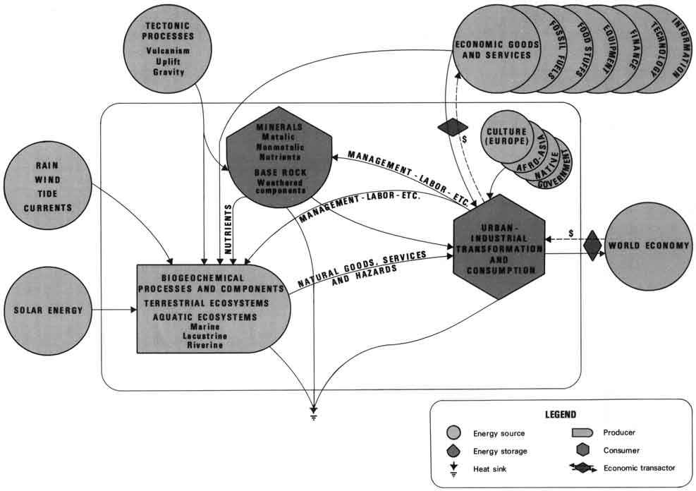
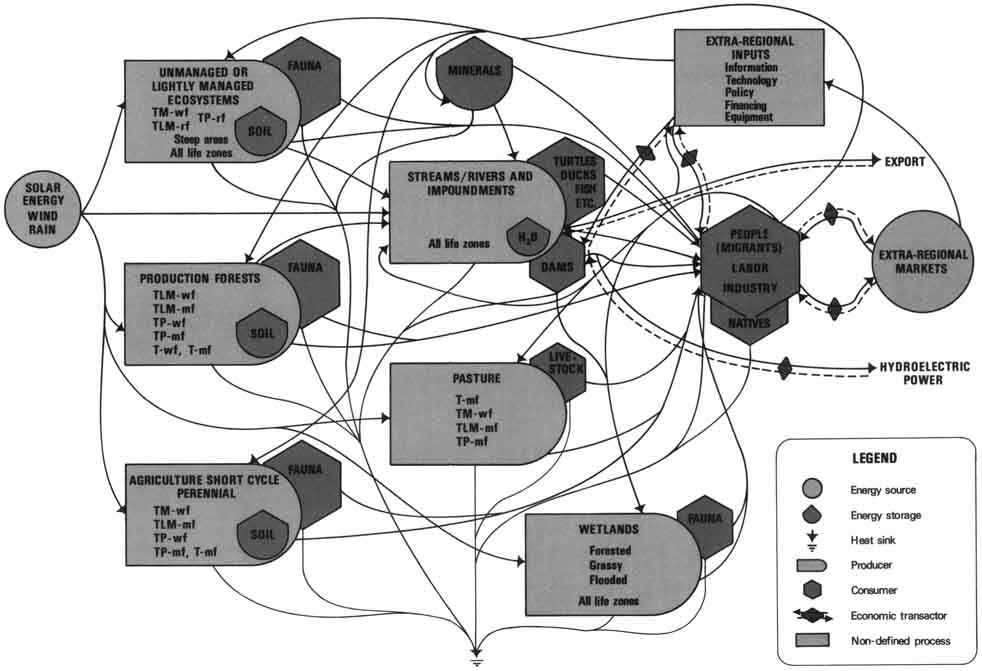
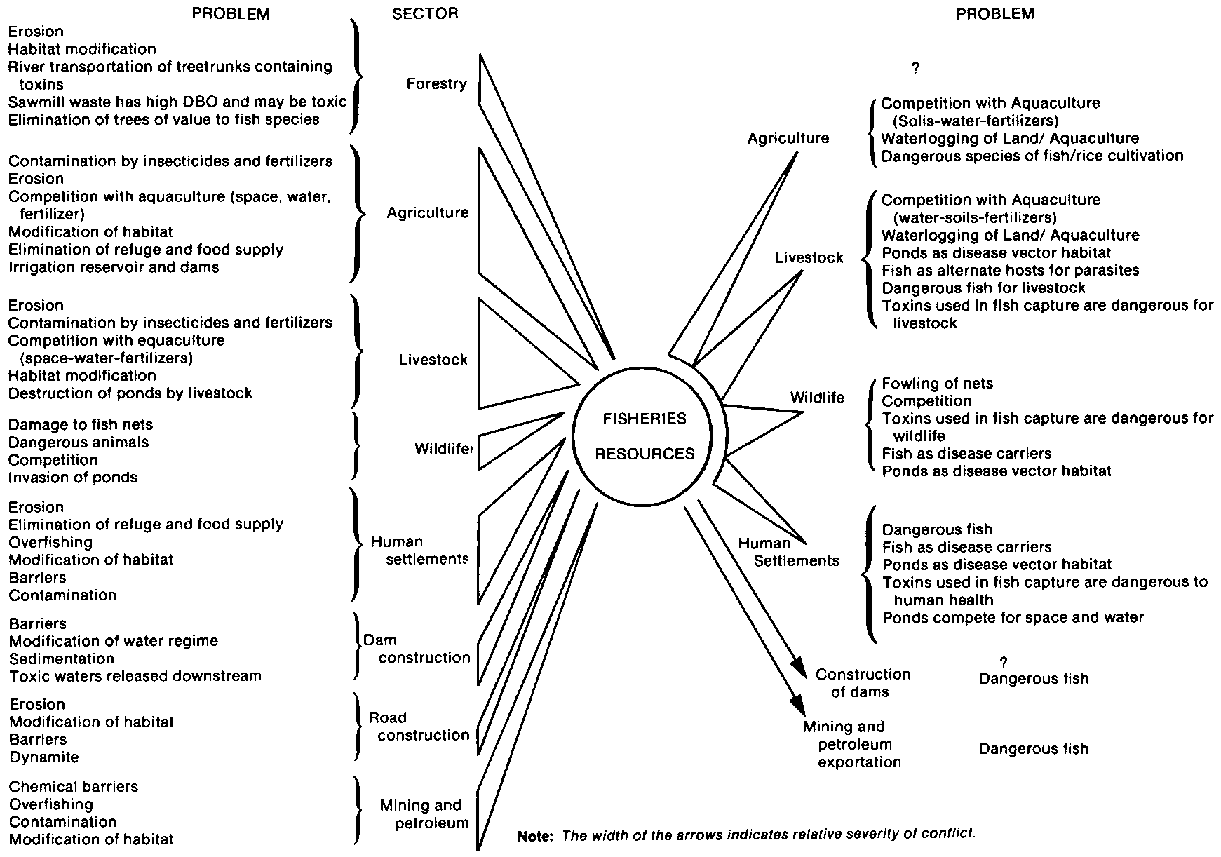
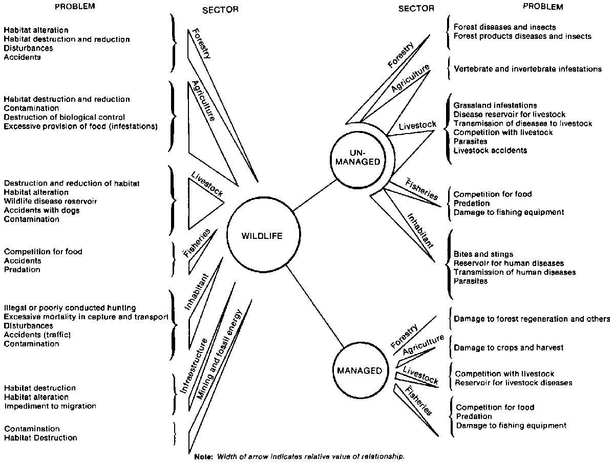
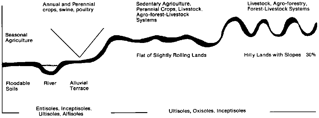