![]()
![]()
![]()
![]()
![]()
Introduction
Evolution of transportation in the Selva
Transportation in the Central Selva today
Road construction and improvement
Bibliography
![]()
The paramount importance of transportation systems in community development is widely known. The objective of transportation is to carry people and goods from one site to another. Consequently, it is an important means of communication and an agent that can both induce favorable socioeconomic change as well as cause serious conflicts with other development activities. It can also immobilize and make unproductive large quantities of capital if it is not suitably used. Even though very little statistical information is available about the Central Selva, it is clear that road construction, maintenance, and vehicle traffic can conflict with other development efforts.
Road construction in the humid tropics in general, and the Peruvian Central Selva in particular, requires analysis of a complex series of factors, set in the context of both the historical evolution of transportation in these areas, as well as in the geography which imposes severe limits on the development of transportation systems.
Peru has been defined as a "terrestrial archipelago" because its inhabitants are grouped into dispersed isolated settlements at different altitudes. The most important barriers to communication between these settlements are coastal deserts, snow-capped peaks, frigid punas, deep canyons, wet tropical forests, and swamps. Production and consumer centers are dispersed throughout the country at altitudes ranging from sea level to 4,500 meters above sea level. Fifty to ninety percent of the prices of agricultural goods produced in the interior and sold on the coast are accounted for by transportation and marketing costs. Historically, roads have been inadequate for the burdens of commerce placed on them.
Four periods in the evolution of Selva transportation systems can be distinguished: Large Expeditions, Steamboat River Navigation, Air Transportation, and Terrestrial Transportation. A few years after the Spanish conquest of Peru, the rumored existence of El Dorado inspired various expeditions into the Selva, beginning with that of Gonzalo Pizarro in 1541. Fantastic descriptions of El Dorado and other such places persisted for more than 100 years, attracting adventurers, miners and missionaries. These expeditions left no road infrastructure, but they did increase knowledge of the region which later contributed to the selection of road locations.
The 19th Century saw a significant worldwide technological change in navigation, with the introduction of steamships. Notably faster on calm sea than sailing ships, steamships became widespread with the decrease in coal and metal prices and the substitution of steel for iron. The first English steamship "Peru" arrived in Callao in November, 1840 followed by the Brazilian ship "Marajo" which appeared in 1853 in Nauta, a settlement on the left bank of the Marañon river, near its confluence with the Ucayali river. At Peru's request the "Marajo" visited the Peruvian Amazon three times a year for an annual fee of 20,000 pesos. From that moment, commerce and development in the Peruvian Amazon depended on ships that came from the east, from Brazil, rather than from distant Lima.
The steamship allowed the Low Selva's natural resources to be exploited. Recognizing the Selva's strategic location, and to counteract its dependence on Brazilian craft, Peru's President, Ramon Castilla, ordered the construction of two steamships, two exploration vessels, and a floating dock capable of accommodating 1,000 ton ships. Operation began in January, 1864 and since then, the Peruvian river fleet has grown. A river port was constructed in 1901 at Iquitos; by the end of the 1970s, ports were also built at Pucallpa and Yurimaguas, replacing natural landings.
Since the steamship began operation, the most convenient way to enter and leave the Peruvian Low Selva was through Brazil via the Amazon river. The alternative was to travel by land for two difficult months over the Andes and through the High Selva on footpaths. In 1863 Raimondi wrote regarding the need to supply river settlements with potatoes imported from Portugal and France that arrived half-decomposed or germinated. Ironically, the mountains in Peru were at that time an important potato-producing region, but could not supply an adjacent area in the same country, because of the lack of transportation.
During this period, several incidents significantly affected the way of life of Selva inhabitants:
1. The production boom of the famous Moyobamba hats attracted international attention, and caused several foreign consulates to be established in that town. This business saw surprising growth until the middle of the 19th Century.2. The rubber boom from 1870 to 1914 subjected the native population to continual plunder of land, property and person, and to epidemics of imported diseases to which they had no resistance (colds, flu, and measles). Brazilian cities (Manaus, Rio Branco, etc.), on the other hand, benefited significantly from the boom's profits.
3. Policies of the Peruvian Government at the end of the 19th and the beginning of the 20th Centuries gave considerable impetus to colonization in the region, but being landlocked and lacking roads the region was unable to support such colonization efforts.
The Air Transportation Period
With the construction of the Iquitos airport in 1930, air traffic began and Iquitos finally became more oriented toward Lima and the rest of Peru instead of to Brazil to which it had been tied physically and economically (Riccioni, 1965). Later, airports were constructed in other Selva localities, and by 1961, the largest volume of passengers and cargo in Peru, larger even than the volume at Lima Airport, passed through Tarapoto airport.
Large areas of the High Selva and Low Selva saw their isolation ended with the arrival of air traffic, but financial and technical limitations (freight, investment, etc.) restricted their social and economic integration into the rest of the country. Most service was provided by single-engine planes.
The terrestrial transportation period began late. "In the jungle area (Selva) no roads have been constructed. Only those localities that can be reached by boat are known and have been exploited. The rest of this vast area has not been exploited and is practically unknown," wrote Davalos and Lisson in 1902. In 1929 Diez Canseco wrote, "East of the mountains, in the forest region, the problem is still worse; in fact, to date, it is unsolvable. The amount of rough terrain and the abundance of rain causes the roads on the hillsides to be permanently threatened by landslides. Where the terrain is more level, the moisture retained by the vegetation converts all land into a quagmire, while bridges grow in number and dimension as the water descends until rivers are encountered that are practically impassable."
Roads rapidly spread through Peru between 1920 and 1930 with the passage of the "Road Conscription" Law by the Leguia government. This law required every citizen age 18-60 to dedicate 12 days per year to road work, which added thousands of kilometers of coast and mountain roads and which contributed to the beginnings of a road network in the Selva. During the 1930s the Chanchamayo Valley (San Ramon and La Merced) in the Central Selva became connected by land with the rest of the country through construction of the Lima-La Oroya-Tauna-La Merced road. After the 1930s, mountain localities were selected as starting points for crossing the Eastern Cordillera to incorporate new areas and settlements in the Selva into the national economy. Roads were built to Quince Mil (1942), Pucallpa (1943), Oxapampa (1943), Puerto Maldonado (1962), Pozuzo (1974), and Tarapoto (1978).
Despite these advances, however, road construction in the Selva has generally been slow and characterized by delays. There have been several reasons for this, including changes in government, economic crises, technical difficulties in construction and maintenance, and unrealized social and economic goals.
Other Methods of Transportation
In most of the country horse and foot paths have been and will continue to be crucial in supporting both new colonies and existing communities that are far from roads. Peru's vast network of paths has been constructed by the users themselves with neither technical assistance nor official financial support, this despite the fact that under the Incas, roads formed large networks and offered well-constructed suspension and floating bridges and roofed resting places (tambos) at regular intervals.
At the beginning of the present century a 580 km railroad line from Tambo del Sol to Pucallpa was planned. Tambo del Sol is located 4,112 meters above sea level along the railroad between Oroya and Cerro de Pasco. The road, passing through Huacho, Oxapampa, Pozuzo and Puerto Inca, was to expand the area influenced by the Central Railroad, so that Lima and the Central Sierra would be connected with the Amazon region. The rails were to reach the navigable rivers on the Atlantic slope, providing an inter-ocean route that would be an alternative to the Panama Canal. Its construction began in the 1950s, but after the construction of only 40 km, the project was abandoned.
Confronted with the expense of construction and maintainance of roads in the Selva, two recent studies considered the possibility of using dirigibles instead. The first analyzed the benefits that dirigibles could bring to the Urcos-Puerto Maldonado Road project area (Cahn-Hidalgo, 1982). The second looked at the Central Selva and concluded that dirigibles would be more efficient and economic than conventional plans (Mayer, 1982). Unfortunately, additional planned investigations comparing dirigibles with terrestrial transportation have not yet been conducted.
All manner of motorized vehicles have been used increasingly in recent decades in the Central Selva to transport products to Lima, where they are most in demand. Increases in the price of forest products have also encouraged farmers to later convert their trails to cart roads.
Road Infrastructure
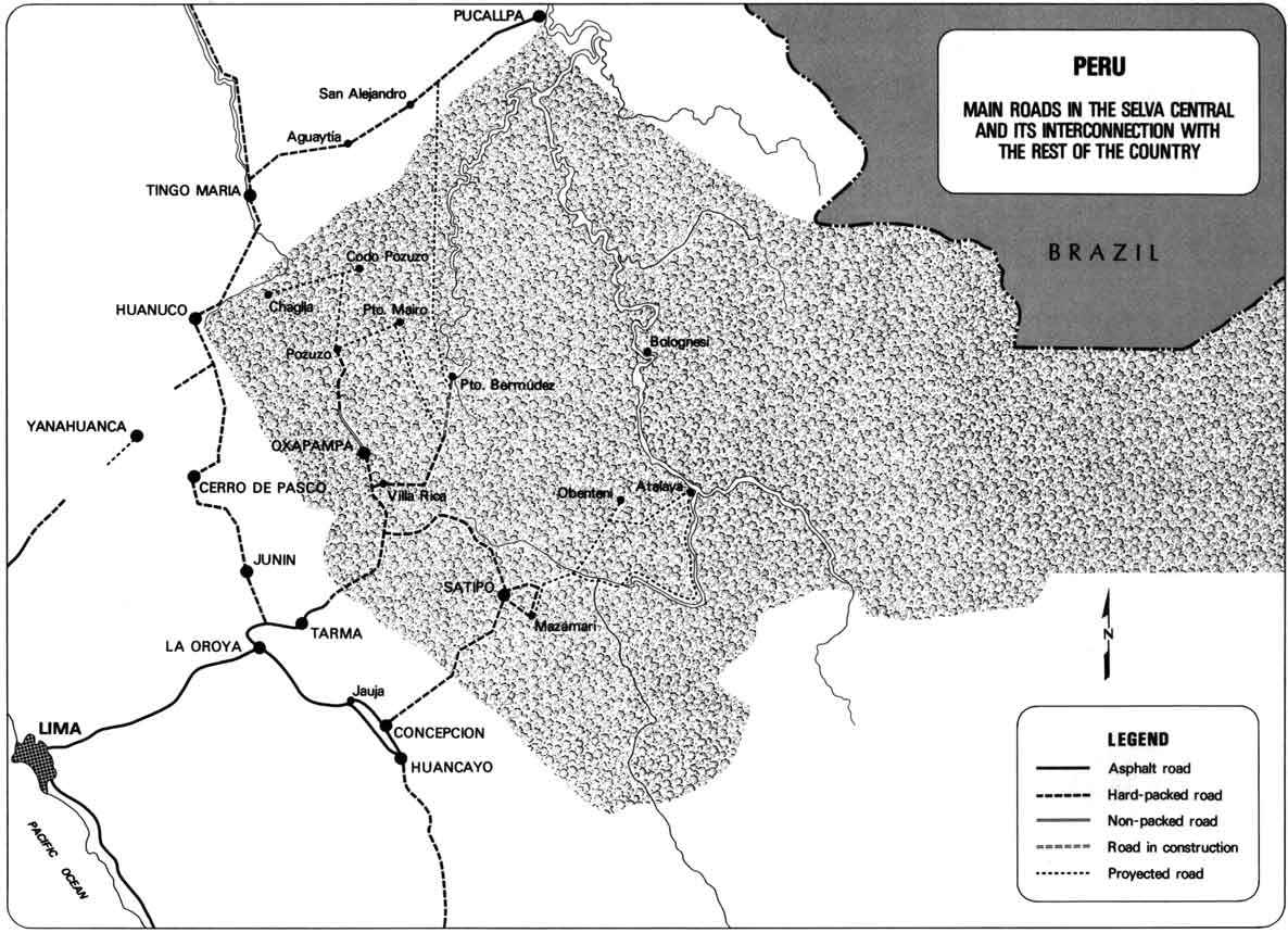
The Central Selva can be reached from Lima by two access roads: the Lima-La Oroya-Tarma-San Ramon road (295 km) and the Lima-La Oroya-Concepcion-Satipo Road (362 km). However, the latter road passes through rough terrain and is little traveled.
Map 14-1 illustrates the principal Central Selva roads and their connections with the rest of the country. Nearly 40 percent (521 km) of the Central Selva roads belong to the national network, of which less than 1.0 percent are paved, 63.2 percent are improved, 23.6 percent are unimproved, and 13.2 percent are cart trails (Table 14-1).
An appreciable length of local roads (725 km) has been constructed over trails cut for timber harvesting by private corporations or by communal efforts. These roads are characteristically straight, without shoulders or drainage ditches, and are often impassable in the rainy season.
Private Transportation Services
Buses and taxis for passengers and 8-12 ton trucks for freight are provided exclusively by private companies and individuals, which are regulated only according to demand and road conditions. Most of these intraregional transport lines originate in, or have as their destinations, La Merced and Satipo. In other parts of the Central Selva accessible by road, service is less satisfactory and more irregular. Passengers usually travel in specially prepared pickups or small trucks, or they can travel in the cab or on platforms of freight haulers. Where there are no roads, irregular service by small planes based in San Ramon or elsewhere outside the Central Selva fill the gap.
In 1982 the Regulatory Commission of Transportation Tariffs established a tariff of approximately US$35.00 per ton of truck-hauled dry cargo. Compliance by the fleet depends on road conditions and negotiations between suppliers and claimants. Generally, suppliers have more power in negotiation.
River Transportation
Air transportation and automobiles have notably reduced the importance of transport by river for both passengers and freight. The principal navigable rivers of the region are the Ucayali, Tambo, Pachitea, Urubamba, and Ene. The Pichis and Palcazu rivers are navigable by smaller boats from their confluence to Puerto Bermudez and Izcozacin, respectively. The Perene river is navigable from its junction with the Ene to Puerto Ocapa. No official infrastructure or port service exists for passenger and freight movement, although natural ports are used, depending on the season and height of the rivers.
River service is limited to areas lacking roads and to transportation over short distances. It is most important east of the Central Selva, in Puerto Inca, Puerto Bermudez, and Atalaya. In these areas rivers contain larger volumes of water, and they are the only means of large scale transportation. The most specialized service with the largest ships is provided by corporations based in Pucallpa. These distribute food, drinks, materials and equipment and transport logs to sawmills in Pucallpa. For small freight cargos, individual enterprises are available with a large variety of boats.
Air Transportation
More than 70 airstrips exist in the Central Selva, most of them without paved runways, appropriate lighting or other facilities. The San Ramon airport has the most air traffic and is able to accommodate DHC-5 planes. Its clay runway is 800 meters long and 40 meters wide (MTC, 1982). DHC-5's may also use the airstrips at Puerto Bermudez, Satipo, Atalaya, Puerto Ocopa, Mazamari, Cotivereni, Rateri, Iscozacin, and Puerto Victoria. Only small planes can use the other strips in the region. Most air traffic occurs in the dry season, from July to October. Users and local governments are largely responsible for maintaining the local air transportation infrastructure.
Five air-taxi companies operate in the Central Selva, offering irregular passenger and freight transportation service. In accord with the Civil Aeronautics Law, they can neither announce nor be subject to flight itineraries, nor can they travel the same routes as the regular air service companies. Fees are set according to trip length and whether passengers and freight will be found for the return flight. Most planes are single-engine, although one company based in San Ramon has 5-twin engine planes.
Geologic and Climatic Characteristics
Central Selva roads traverse the forested foothills of the High Selva and the Amazon Plain. The foothills, outcrops of the Cordillera Oriental, are characterized by canyons, deep ravines, and narrow valleys. Its rivers flow over varied types of rocks which produce small falls, surface erosion, and occasional flash floods during the rainy seasons.
The Amazon Plain, meanwhile, is relatively flat. The pressure of heavy rainfall, the runoff from the highlands, and seasonal overflowing of riverbanks deposit combinations of organic and inorganic material on the land; the different layers of these deposits, which are usually called "incoherent" units, do not provide a good surface for road construction.
Population Distribution
Population density in the Central Selva is only 0.02 people per hectare while the national density is 0.12 people per hectare. The ratio of agricultural land to inhabitant is 11 hectare per person, while the national ratio is only 4.28 hectare per person. Almost 70 percent of the population is concentrated on 11.4 percent of the useful land located near access roads and on lands that are predominantly protected (stretches of the Chanchamayo, Oxapampa, and Satipo). Eighty percent of the populations are rural while the urban population is concentrated in San Ramon, La Merced, Satipo, Oxapampa, Puerto Bermudez, and Villa Rica, with populations that vary from 4,000 to 12,000. Other settlements contain 200-400 inhabitants. In roadless areas, settlements of both colonists and natives are generally located along riverbanks (INP, 1981 a).
Table 14-1
CENTRAL SELVA ROAD NETWORK (January 1980)
|
|
TOTAL |
IMPROVED |
UNIMPROVED |
TRAIL |
||||||||
|
Km |
%a |
%b |
Km |
%a |
%b |
Km |
%a |
%b |
Km |
%a |
%b |
|
|
National Network |
521 |
39.9 |
100.0 |
329 |
94.5 |
63.2 |
123 |
64.7 |
23.6 |
69 |
9,0 |
13.2 |
|
Departmental Network |
59 |
4.5 |
100.0 |
9 |
2,6 |
15.3 |
29 |
15.3 |
49.2 |
21 |
2.7 |
35.5 |
|
Local Network |
725 |
55.6 |
100.0 |
10 |
2.9 |
1.4 |
38 |
20.0 |
5.2 |
677 |
88.3 |
93.4 |
a. Structure according to the type of network (vertical).
b. Structure according to the road surface (horizontal).
Source: MTC (1980).
Road Investment and Planning
Building a road in an area of little economic activity and away from large population centers requires careful integration using micro-regional plans and multiple objectives. When planning for expansion or development in agriculture, mining or other production sectors, officials tend to forget that transportation costs are an important part of the expense that should be factored in from the beginning in order to increase the demand for transportation and thus justify the considerable investment in road-building.
The 1981 -1985 Central Selva public investment program for the transportation sector is a major part of the strategy and policies of the "Central Selva Development Plan" (INP, 1981 a) and the "1981 -1985 Medium-Range Investment Program" (INP, 1981 b). Transportation sector projects represent 82 percent of the total projected investment for the Central Selva; for the rest, 9 percent goes to support production, 4 percent for regional plans and support of micro-regional administration, 3 percent for social services, and 2 percent for baseline studies. Among the basic infrastructure projects the most important is the construction and improvement of the Selva Marginal Road, which accounts for 30 percent of the investment in the region.
Technological Design Standards
The "Peruvian Road Design Standards," developed in 1970 by the Road Infrastructure Office of the Ministry of Transportation and Communication, specifies how the slope, banking, and curve radius of the roads must be designed to suit the topography and the volume and speed composition of the expected traffic. These standards are adapted from studies conducted in the United States in 1965 by the Highway Research Board. Although these standards are based on traffic and road conditions in the United States, they have been adopted with few changes by almost all other countries because of the lack of local studies that allow site-appropriate projects to be developed. The current system is incompatible with the rough terrain and heavy vehicles (trucks) common to the Central Selva. Others (Holguin, 1980; the International Labor Office and the World Bank) have also pointed out that it is inappropriate to apply imported standards and techniques to road construction (Allal and Edmonds, 1977). While these standards may occasionally be suitable to the conditions in developing countries like Peru, in most cases they are inadequate economically and culturally.
Inappropriate standards and poor administration, meanwhile, have caused the number of automobiles in Peru to grow too large for the road infrastructure, while freight surveys conducted in 1978 and 1981 revealed that illegally large cargos are being carried on a high percentage of roads by almost 75 percent of double-axle vehicles. Excessively heavy cargos accelerate pavement deterioration and considerably increase maintenance costs. In addition, they threaten the majority of bridges, which are old and which were not constructed to support such cargos. (Urbina, et at, 1982).
Principal Construction Activities
To build a road, land has to be cleared of trees, plants and animals. The width of the area to be cleared varies according to topography and vegetation, but an average width is approximately 20 meters on each side of a road, to allow enough space for levelling and construction and also to serve as a buffer area to prevent the weight of large falling trees from damaging road banks and to prevent tree branches from falling on roadbeds.
Thus, a strip 40 meters wide is often left without plant cover and exposed to the elements for a considerable length of time. The mechanical force of rainwater can erode this land and carry off sediments and organic material to water courses, while the fauna that lived along the road site are forced out, or prevented from migrating across such a barrier.
Drainage and earth movement are the principal problems confronting road builders in the humid tropics. The function of drainage works is to capture and dispose of water as quickly as possible. Central Selva roads lack adjacent drainage ditches and thus they are subject to attack by water, which reduces soil resistance and causes the road base, sub-base and surfaces to wash out. Precipitation flows off the land's surface, filters through the soil, or evaporates. As surface runoff, it forms small channels that eventually meet to form rivulets and then streams, roads frequently impede this natural runoff. Without drainage works, large puddles form in the road way, and water infiltrating the subsoil tends to gush from the banks and road surface.
If the road is located on a slope, the water's mechanical action increases, but the resulting gullies are well-defined and thus can be controlled. If the road is located on flat terrain in tropical regions, drainage problems are much worse, because the channels are not well-defined. Alteration of the free flow of water affects the development of some plant species; affects migrations, reproduction, and feeding of fish; and increases sediment loads that fill river channels, eventually forming islands and changing river bottom configurations which can adversely affect river transportation and riverbank settlements and production. Consequently, a significant concern of planners in the humid tropics is to find suitable areas for roads to minimize drainage problems and, thus, the costs of road maintenance.
Much of the cost of road construction is incurred by levelling and excavating the road bed, and these costs are affected by topography, geotectonic conditions, height of the road bed, and the cost of moving earth. If the road right of way is flat, the road will be supported on a terrace, a structure made with material from the site or from elsewhere. However, not all soil material in the Low Selva is suitable for constructing terraces and often this material must be transported long distances. If the terrain is hilly, stretches can be built with on site material and on fill, but in montainous areas large scale earth-moving is required. If the slope is excessive, tunnels and retaining walls may have to be built. In some cases, the cost of levelling approaches 75 percent of the total and is increasing (Holguin, 1980).
The project engineer, for economic reasons, must compensate for excavated on-site material and avoid the excessive use and transport of fill materials from other localities. To this end, the engineer will try to alter slopes, and increase or reduce vertical curves to reduce construction costs.
In the Selva "incoherent" units (expansive clays and marshy areas) are frequent. Construction material is scarce. Increasing the amount of on-site excavated material to compensate for the scarify of material lowers the road closer to the water table. This will require additional drainage works and thicker pavement and, consequently, increased costs. At the same time, extracting material from alongside the construction site can significantly alter topography, vegetation, runoff, etc., away from the road site. Excavation of hillsides can disrupt their natural equilibrium and cause landslides that obstruct water courses with sediments, unless such preventive measures as retaining walls are employed.
The materials adjacent to the road and in quarries are an important factor in construction costs. The absence of material will require transporting rock and sand from distant localities, as frequently happens in the Peruvian Selva. In one project, for example, rock was transported to the Iquitos airport from a site (Aguaytia) 10 days distant by barge, and one more day by truck. Rocks and cement were transported to Inapari by cargo planes; cement from Lima was loaded on boats at the port of Callao, taken through the Panama Canal to Belem do Para in Brazil, and then carried up the Amazon to Iquitos.
The cost of moving earth, meanwhile, depends on the unit cost of each one of the following activities: excavation at the construction site; excavation at other sites; compaction of site material in the terrace; compaction of terrace material obtained away from the site; transport of site material to the terrace; transport of waste material away from the site; and transport of material obtained at other sites to the terrace.
Careful maintenance makes transportation more economical and inexpensive transportation is vitally important to Peru's commerce and regional integration. In spite of this, no clear road maintenance policy has been established to date, road maintenance budgets have always been insufficient, and the road network has seriously deteriorated.
Maintenance consists of routine and periodic activities. Routine activities are carried out throughout the year to correct small problems and ensure the efficient functioning of all parts of the road infrastructure. Periodic road sections that have deteriorated from traffic and weather conditions are repaired, with the most effort dedicated to drainage and support of the roadbed. Drainage works are cleaned before, during, and after the rainy season to prevent obstruction and structural damage.
Construction and Maintenance Costs
Road construction costs vary according to soil, climate, topography and the availability of local resources, such as labor and construction materials. Both workers and materials are scarce in the Selva. Even though there is plenty of wood, managers of large projects prefer to use traditional materials such as glazed concrete and corrugated pipes which they must import. Smaller projects, however, do use wood in drainage works, which significantly reduces the costs.
Extracting material from quarries widens the geographic area to be affected by a new road, and may require roads to connect the quarry areas with the road under construction. The construction of a new road in the humid tropics can threaten the stability or existence of ecosystems in the road's vicinity and make permanent changes in human and animal populations. Roads permit spontaneous immigration of the poor, who may immigrate to the jungle to feed their families on the wild flora and fauna there, and to harvest some forest products they can sell to acquire needed goods in the markets. Meanwhile, intense road traffic creates a practically uncrossable barrier to the migrations of some insects and animals. The few animals that do attempt to cross roads expose themselves to being run over or hunted, for the roads facilitate illegal trafficking in and exploitation of protected areas and wildlife. Only multi-disciplinary research can lead to an objective, detailed understanding of the possible conflicts and hazards of building a road system through a given area.
At present, feasibility studies are required to consider route alternatives. These studies should consider variables such as hydrology, meteorology, soils, geotectonics, and seismic hazards and should focus on natural resource potential. Technical and economical calculations need to be employed to determine the road's benefits. Such analysis should be complemented by anthropological and sociological studies, as well as investigation into the project's impact on flora and fauna. If a road project is well conceived, executed and maintained, and if road side settlements are planned, its negative impact will be significantly reduced compared to that caused by poorly-maintained roads and by the activities of spontaneous migrants along new roads.
Table 14-2
THE PERUVIAN ROAD NETWORK
|
Surface |
National |
Departmental |
Local |
TOTAL |
|||||||||
|
Coast |
Mountain |
Selva |
Subtotal |
Coast |
Mountain |
Selva |
Subtotal |
Coast |
Mountain |
Selva |
Subtotal |
||
|
Paved |
3,945 |
878 |
230 |
5,053 |
799 |
293 |
6 |
1,098 |
751 |
85 |
4 |
839 |
6,990 |
|
Improved |
496 |
4,780 |
1,747 |
7,023 |
479 |
2,179 |
75 |
2,733 |
567 |
1,874 |
419 |
2,859 |
12,615 |
|
Unimproved |
49 |
2,594 |
147 |
2,797 |
692 |
4,277 |
308 |
5,277 |
878 |
5,173 |
524 |
6,575 |
14,643 |
|
Trails |
314 |
303 |
397 |
1,014 |
946 |
2,272 |
207 |
3,425 |
6,807 |
16,573 |
2,327 |
25,708 |
30,147 |
|
Total |
4,804 |
8,556 |
2,521 |
15,882 |
2,916 |
9,020 |
595 |
12,532 |
9,003 |
23,705 |
3,274 |
35,982 |
64,395 |
|
Region |
Paved |
Improved |
Unimproved |
Trails |
Total |
% | |||||||
|
Coast |
5,495 |
1,542 |
1,619 |
8,067 |
16,723 |
26 |
|||||||
|
Mountain |
1,256 |
8,833 |
12,044 |
19,148 |
41,281 |
64 |
|||||||
|
Selva |
240 |
2,241 |
979 |
2,931 |
6,391 |
10 |
|||||||
Allal, M. and G.A. Edmonds. 1977. Manual de uso intensivo de mano de obra en la construcción de carreteras. Oficina Internacional de Trabajo (OIT).
Cahn-Hidalgo, G. 1982. "Aspectos relacionados con dirigibles" Estudio de factibilidad "Carretera Urcos-Puerto Maldonado". LAGESA y B.W. As. Ministerio de Transporte y Comunicaciones. Lima, Peru.
Dávalos and Lisson. 1902. Las vías de comunicación en el Perú. New York.
Diez Canseco, E. 1929. La red nacional de carreteras. Lima, Peru.
Holguín, L. 1980. Conceptos de diseño, nivel de servicios y evaluación de la capacidad en carreteras de montaña. Bogotá, Colombia.
(INP) Instituto Nacional de Planificación. 1981. Programa de desarrollo de la Selva Central. Lima, Peru.
(INP) Instituto Nacional de Planificación. 1981b. Programa de Inversiones a Mediano Plazo 1981-1985. Lima, Peru.
Mayer, N. 1982. Estudio de dirigibles para la utilización en la región de la Selva Central. MTC, NASA. Lima, Peru.
(MTC) Ministerio de Transportes y Comunicaciones. 1970. Normas peruanas para el diseño de carreteras. División de Infraestructura Vial (DIV). Lima, Peru.
(MTC) Ministerio de Transportes y Comunicaciones. 1980. "Estudio de Transportes y Comunicaciones" (Prefactibilidad). Oficina de Estudios Económicos. Vol. 2, Cap. IV. Lima, Peru.
(MTC) Ministerio de Transportes y Comunicaciones. 1982. Aeropuertos y aeródromos del Perú 1982. Dirección de Infraestructura Aérea. Lima, Peru.
Riccioni, Angelo. 1965. Plan Vial Nacional 1966-1975. INP. Lima, Peru.
Urbina, W., J. Melgar and R. Flores. 1982. El Mantenimiento de carreteras en el Perú. Lima, Peru.
![]()
![]()
![]()
![]()