![]()
![]()
![]()
![]()
![]()
Water resources in the Central Selva of Peru
Present water use and existing development plans
Measures required for water exploitation
Identification of conflicts with other interests
Bibliography
![]()
In this chapter we discuss atmospheric, surface, and subterranean water resources of the Central Selva, and the ways to insure their efficient distribution for drinking, industry, irrigation, and hydroelectric power. Other chapters in this study focus on water's role in conservation, navigation, and as habitat for aquatic species. We also plan to identify the interactions between water use projects and those which further various other development interests.
The rivers in the Central Selva arise high on the Atlantic slope and form part of the Ucayali watershed. With the Marañon, these rivers give rise to the Amazon River which empties into the Atlantic Ocean. All of them are winding; they form a network of channels that ultimately flow into the major watersheds of the Perene and Pachitea Rivers. Metereologic, hydrometric and topographic information about the rivers is scarce, with existing data describing only some of them (the Paucartambo, the Perene, the Ene, and the Tambo), expressed on photographic maps of the scale of 1:1,000,000. What is known is that the rivers are caused and nourished by the abundant precipitation of this humid region. Compared with rivers in the Brazilian Amazon watershed near Peru, some of the rivers of the region have high water volumes (Tables 5-1 and 5-2). While future systematic evaluation of river volume at gauging stations can reveal the true potential, some preliminary studies can give an idea of the watersheds' future. Table 5-3 presents some estimates for volume changes in the Ene and Tambo rivers, while Table 5-4 gives estimates on the sediments in those rivers.
Table 5-1
SPECIFIC FLOW VOLUMES OF AREA RIVERS
|
River |
Q (m3/s)a |
Area (km2) |
q(1/s/km2)b | |
|
Ene (Achaminga) |
1,928.0 |
106,150 |
18.2 |
(1) |
|
Tambo (Antario) |
2,343.0 |
125,130 |
17,7 |
(1) |
|
Pachitea |
1,279.0-2,411.9 |
28,652 |
44.6-84.2 |
(2) |
|
Palcazu |
761.0 |
9,840 |
77.3 |
(3) |
|
Paucartambo |
108.4 |
2,988 |
36.3 |
(3) |
|
Satipo |
91.7 |
1,579 |
58.1 |
(3) |
|
Pichanaki |
46.9 |
569 |
82.4 |
(3) |
|
Chanchamayo |
198.0 |
7,655 |
25.9 |
(3) |
|
Tulumayo |
86.1 |
3,345 |
25.7 |
(3) |
|
Palca |
98.0 |
3,949 |
24.8 |
(3) |
a. Volume by surface area.
b. Volume by unit.
(1) With gauges.
(2) The lower figure was obtained by the Federal Republic of Germany; the higher by ONERN.
(3) Figures obtained by ONERN.
Source: ONERN (1980); Federal Republic of Germany (1979).
The hydroelectric potential of the area's rivers (Table 5-5) is very large when compared with the energy needs of the area and the country as a whole, which, in 1981, consumed approximately 8,000 giga watt hours (GWH) and had a developed capacity of 3,282 megawatts (MW). If this potential is developed in the Central Selva where needs are small, principally in the highlands, it can be seen that the area can export large amounts of energy to more developed areas that lack this resource. Ground water will not play a role in hydroelectric power because of poor permeability and mediocre physical-mechanical quality of the terrain. Nevertheless, ground water presently plays an important role for human populations, and good yields can be obtained from wells.
Table 5-2
SPECIFIC FLOW VOLUMES IN RIVERS OF THE BRAZILIAN AMAZON
|
River |
Q(m3/s) |
Area (km2) |
q(l/s/km2) |
|
Moa |
36.0 |
1,210 |
30.0 |
|
Ituxi |
341.0 |
14,205 |
24.0 |
|
Madeira |
16,817.0 |
934,300 |
18.0 |
Source: Federal Republic of Germany (1979).
Table 5-3
HIGH WATER VOLUMES IN THE ENE AND TAMBO RIVERS
|
River |
Area (km2) |
11 years (m3/s) |
25 years (m3/s) |
10 years (l/s/km2) |
25 years (l/s/km2) |
|
Tambo (Puerto Prado) |
125,000 |
20,000 |
23,080 |
160 |
190 |
|
Ene (Paquitzapango) |
105,000 |
16,700 |
19,000 |
159 |
189 |
Source: Federal Republic of Germany (1979).
Table 5-4
SEDIMENT LOAD IN THE ENE AND TAMBO RIVERS
|
River |
Annual Water Flow Discharge |
Annual Sediment Flow Discharge |
|
Tambo (Puerto Prado) |
74,000 |
125 |
|
Ene (Paquitzapango) |
60,000 |
105 |
Source: Federal Republic of Germany (1979).
Chanchamayo Watershed
The Chanchamayo watershed, made up of the Tulumayo, Palca, and Oxapampa rivers, is the most developed area in the Central Selva. With Tarma (in the Palca watershed), San Ramon, La Merced, and the extensive agricultural areas around them are major population centers.
A hydroelectric plant belonging to ELECTROPERU lies between San Ramon and La Merced and uses water drawn from the Chuchuyacu River. The plant is small, with two 276 KW turbines that each handle 600 liters/second and a fall of 120 meters. This installation does not provide enough electricity for the populations of these two towns, although two 400 KW diesel engines and one 600 KW engine are operating.
Table 5-5
HYDROELECTRIC POTENTIAL IN THE PERUVIAN CENTRAL SELVA
|
Watershed/River |
Site |
Potential (MW) |
Mean Energy |
|
Tulumayo |
Tulu 10 |
155.5 |
832,0 |
|
Tulu 20 |
166.5 |
1 079.2 |
|
|
Tulu 30 |
215.5 |
1 336.1 |
|
|
Tulu 50 |
243.0 |
1 510.0 |
|
|
Tulu 70 |
198.6 |
1 239,8 |
|
|
Subtotal |
979.1 |
5 997.1 |
|
|
Palca |
Palca 10 |
147.8 |
920.7 |
|
Palca 15 |
122.5 |
798.6 |
|
|
Palca 30 |
55.2 |
338.2 |
|
|
Subtotal |
325.5 |
2 057.5 |
|
|
Oxapampa |
Oxa 20 |
111.7 |
753.0 |
|
Oxa 30 |
35.5 |
249.6 |
|
|
Subtotal |
147.2 |
1 002.6 |
|
|
Total |
1 450.8 |
9 057.2 |
|
|
CHANCHAMAYO PAUCARTAMBO |
Chan 10 |
70.4 |
438.7 |
|
Chan 25 |
139.5 |
944.2 |
|
|
Chan 29 |
163.8 |
1 003.9 |
|
|
Chan 30 |
96.8 |
669.2 |
|
|
Total |
470.5 |
3 056.0 |
|
|
PERENE (Total) |
Per 10 |
212.2 |
1 480.8 |
|
Per 20 |
67.1 |
416.1 |
|
|
Per 70 |
395.6 |
3 087.7 |
|
|
Total |
674.9 |
4 984.6 |
|
|
SUMMARY: |
|
|
|
|
PERENE (Total) |
|
2 597.2 |
17 097.8 |
|
Enea |
Ene 40 |
2 227.1 |
18712.4 |
|
Tambo |
Tam 40a |
1 286.5 |
8 324.8 |
|
TAMBO |
Subtotala |
6 110.8 |
44 135.0 |
|
POZUZO |
Poz 20 |
96.2 |
733.8 |
|
Poz 27 |
237.8 |
1 473.7 |
|
|
Poz 30 |
390.1 |
2 762.4 |
|
|
Poz 50 |
138.3 |
868.5 |
|
|
Subtotal |
862.4 |
5 838.4 |
|
|
Area |
General Total |
6 973.2 |
49 973.4 |
a. Not including the potential of the Mantaro nor the Apurimac.
b. Outside, but adjacent to the area.
Source: Federal Republic of Germany (1981).
The food canning factory must use emergency equipment, since there is no daytime electric light, except during predetermined hours. Recent annual electricity consumption in the two towns was 4,630 KW in terms of energy and 1,652 KW in terms of maximum demand. A hydroelectric plant with approximate capacity of 6,300 KW is being constructed for the San Vicente mine on the Oxapampa River near San Ramon.
Clean drinking water for the two populations (CEPIS, 1980), reaches only 60 percent of the people in San Ramon and 50 percent in La Merced. While large consumers such as the food canning factory enjoy regular supplies from a well, none is provided to average customers throughout the day, and many homes are not even connected to pipelines. Although there is no scarcity of clean spring water, the growing populations need to use surface water, incurring increased pumping and treatment costs. Many homes take their water directly from the rivers, which are continually polluted by direct dumping of waste water.
Paucartambo Watershed
The Paucartambo river, which together with the Chachamayo forms the Perene, features rapids, many bends, and clearer water than the Chanchamayo. The Yaupe hydroelectric plant, with 108 KW capacity, has been installed along this river's headwaters. It belongs to the Central Mining Corporation and supplies electricity to the firm's mining operations in the Central Region of the country. ELECTROPERU is investigating the possibility of constructing a small plant on the Oxapampa river to serve the population in the Paucartambo area, while a definitive study has been prepared of the Yuncan Hydroelectric Plant on the Paucartambo river, above Yaupe.
Perene Watershed
Long and narrow motorized boats transport goods on the Perene River between the city of San Luis de Shuaro and the river's confluence with the Pangoa river. The river's waters are also used to irrigate citrus fruit plantations.
Pichanaki Watershed
On the Pichanaki River, a tributary of the Perene, a plant of approximately 1,000 KW capacity which will exploit a fall of 200 meters is being constructed near the population center of Bajo Pichanaki to serve both Bajo and Alto Pichanaki.
Pengoa Watershed
Two important population centers, Satipo and Mazamari, are in the Pangoa river watershed, which is made up of the Satipo, Mazamari, and Sonomoro rivers. The electricity consumption of these two cities, not including the special uses already described, was expected to be 839 KWh of energy and 420 KW of maximum demand. But both are experiencing problems similar to other cities: insufficient quantities of drinking water and electrical energy, and water that is supplied only during certain hours of the day. Satipo uses almost no well water.
Thermal diesel plants provide Satipo with electricity at present, but ELECTROPERU is considering constructing a hydroelectric miniplant on the Sonomoro river. Also being investigated is the possibility of constructing a 3,000 KW plant on the Chalhumayo to serve the town of Mazamari.
Tambo Watershed
The feasibility of constructing large hydroelectric plants on the Tambo river and its tributaries, the Perene and the Ene, is being studied. These would provide energy to localities outside the Selva. Two hydroelectric development alternatives are also being considered for a 200 km stretch along the Ene and Tambo rivers (Figure 5-1). Each requires a huge investment, yet both alternatives are economically attractive, and they could meet the region's rising electricity demand for the next 15 years.
Tables 5-6 and 5-7 show the impact of such projects on the river and adjoining areas and their principal characteristics, such as the relation between volume available to the turbines and the mean annual volume; firm power and average power; their installed potential; the relation between usable volume and annual drainage; and the range of variation of reservoir water levels during the reservoirs' operation.
These plant feasibility studies have also considered the area's seismic problems, although the most significant seismic activity occurs in the coastal region and diminishes as one approaches the jungle. It is felt that shock wave magnitudes lower than mb=5 would not cause serious damage to the structures. Thus, only earthquakes of tectonic origin were examined. Few cases of magnitudes greater than mb+6.2 were noted north of the area where the dams would be located, but one seismic magnitude of mb+4.5, which occured a short distance from the Ene-Paquitzapango locality, was considered significant regarding future dam design.
Oxapampa Watershed
In Oxapampa, as in other towns in the region, a shortage of electricity is creating a number of self-producers. Without considering the so-called special uses, it is estimated that energy consumption soon could reach 418 MWH, and maximum demand could reach 213 KW.
The Oxapampa city water supply comes from the San Alberto river, from which it is collected by a simple impoundment system administered by the Provincial Council. Rural areas, however, obtain their water directly from rivers and wells and are, consequently, experiencing contamination problems. To meet the town's needs, studies have been conducted regarding construction of hydroelectric plants on the Pozuzo and Oxapampa rivers. As these plants are relatively large, they would serve Villa Rica as well as other towns in the region.
Figure 5-1 - DEVELOPMENT ALTERNATIVES ON THE ENE AND TAMBO RIVERS
Table 5-6
ENERGY CHARACTERISTICS OF LOCAL HYDROELECTRIC PROJECTS
|
Project |
Installed Potential |
Energy Produced |
Range of Operation |
|
|
(MW) |
Fixed |
Average |
(m) |
|
|
Sumabenia |
1,680 |
2,915 |
8,190 |
20 |
|
Paquitzapango |
2,620 |
7,085 |
12,380 |
20 |
|
Puerto Prado 40 |
980 |
2,835 |
5,380 |
20 |
|
Total Alt. 1 |
5,280 |
12,835 |
25,950 |
- |
|
Sumabeni |
1,680 |
2,910 |
8,185 |
20 |
|
Cutiverini |
1,470 |
2,945 |
6,295 |
15 |
|
Puerto Prado 90 |
2,600 |
6,655 |
12,945 |
20 |
|
Total Alt. 2 |
5,750 |
12,510 |
27,425 |
- |
a. Outside the Selva area.
Source: Federal Republic of Germany (1981).
Pozuzo Watershed
The Pozuzo river has a number of potential damsites. The river could be diverted through tunnels in the Yanachaca cordillera, and, as the river is tightly enclosed by canyon walls until the "Pozuzo elbow," the local impact would be minimal, even if the new plants produced over 60 MW.
The feasibility of constructing a 1,000 KW plant on the Huacabamba river to serve the town of Pozuzo is being studied. The possibilities for constructing small hydroelectric plants on these rivers also appear favorable (a factory producing small Pelton wheels is located in the region). In 1982 a consumption of 36 MWH and a maximum demand of 25 KW was predicted without taking into account special uses.
Villa Rica suffers from light and water problems similar to those of other cities in the region. Without considering special uses, the town consumed 418 MWH of electric energy in 1982, with a maximum demand of 200 KW.
Ground water (springs) will continue to be used by rural households and small populations. Although its use is not practical for agricultural and investment operations which require vast amounts of water, it can be used for industrial purposes when surface water is not available and when pumping the water can be economically justified.
Table 5-7
HYDRIC CHARACTERISTICS OF LOCAL HYDROELECTRIC PROJECTS
|
Project |
Mean Water Volume Qm(m3/s) |
Flooded Area (km2) |
Turbines Qt/Qmb |
Coefficients Spillways Qmax/Qmc |
Reservoirs Vu/Vab |
|
Sumabenia |
1,790 |
131.0 |
1.5 |
26.5 |
0.5 |
|
Paquitzapango |
1,900 |
423.0 |
1.4 |
23,9 |
1.8 |
|
Puerto Prado 40 |
2,340 |
25.6 |
1.5 |
23.2 |
0.1 |
|
Total Alt 1 |
- |
579.6 |
- |
- |
- |
|
Sumabenia |
1,790 |
131.0 |
1.5 |
26.5 0.5 |
|
|
Cutiverini |
1,900 |
423.0 |
1.4 |
23.9 |
1.8 |
|
Puerto Prado 90 |
2,340 |
126.0 |
1.5 |
26,2 |
0.3 |
|
Total Alt 2 |
- |
503.0 |
- |
- |
1.2 |
a. Outside the Selva area.
b. Turbine volume over mean volume.
c. Maximum volume of the spillway over the mean volume.
d. Useful reservoir volume over the annual runoff volume expressed in the number of months of annual mean water volume.Source: Federal Republic of Germany (1981).
From this summary of the rivers and watersheds, it can be seen that the Central Selva region contains abundant water resources that have yet to be fully exploited. Existing plans for their utilization, except for the Ene-Tambo hydroelectric effort, are relatively modest when compared to the area's true potential.
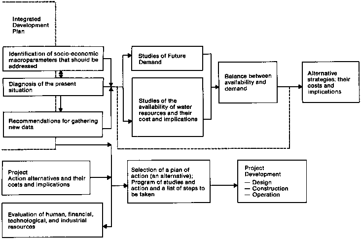
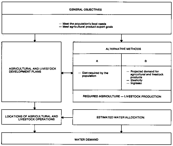
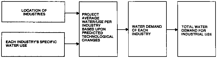
The measures that must be taken to utilize water resources begin with the planning phase. Once a region containing water resources is identified, and an area that can use the resources proposed, the planner evaluates the social and economic benefits of the proposal, collecting basic data to determine water demands and to quantify available water resources. He studies future demand which depends closely on fixed social and economic parameters, such as agriculture and livestock production, urban population growth (including migration), water needs for predicted industrialization, and water and energy consumption by unit produced (Figure 5-2, Figure 5-3, Figure 5-4, Figure 5-5, Figure 5-6).
He must then evaluate the goods and services provided by water. Water demand, for example, must be satisfied at any cost, but for washing salts, it is necessary to determine the demand modules per soil unit through experiments on pilot areas. Likewise for contamination dilution demand it is necessary to determine contamination loads, pretreatment possibilities, and the water quality to be permitted following dilution. Sport and commercial fishing need to be identified, and their requirements established in accord with predicted annual yields of fish.
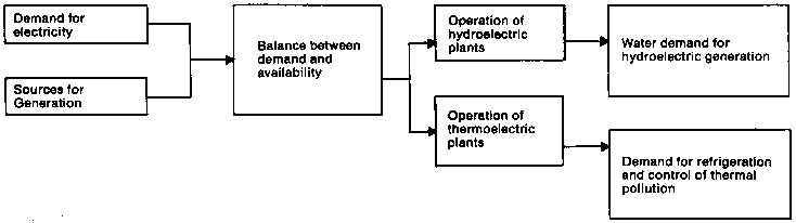
A small difference exists between hydroelectricity demand studies and studies of water demand for other purposes; electricity demand can be met by other than hydroelectric sources, while, for other uses, substitutes for water do not exist (Figure 5-3). The problem becomes even more complicated when the electrical systems under consideration feature hydroelectric plants interconnected with thermoelectric facilities. Thus, water demand for hydroelectric power can only be determined by noting the difference between electricity demand and the availability of all electricity-generating sources.
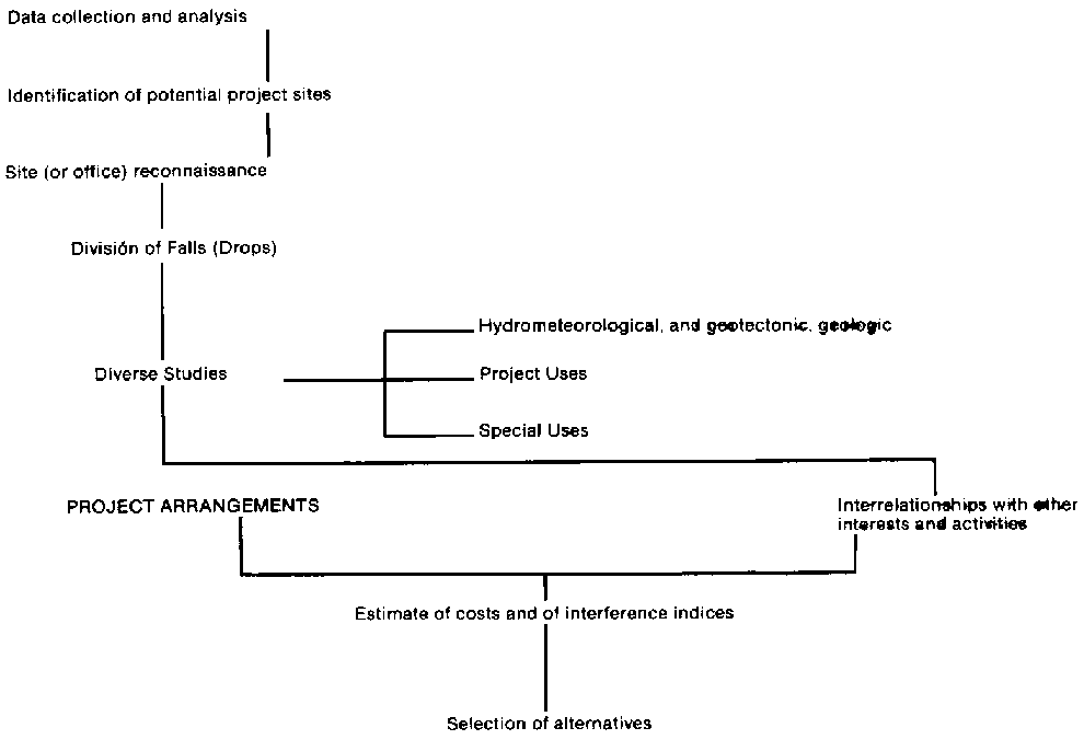
Among the more important aspects of planning are determining the availability of water resources, the cost of exploiting them, and the specific global implications of such exploitation. Such investigations are a necessary preliminary step to defining the programs and strategies to be carried out. Studies looking at the development potential of the resources need to pass through a process that begins with an inventory and that continues to pre-feasibility and feasibility investigations until final decisions are made for developing the project. (Figure 5-7) Such studies must also identify conflicts that can arise because of resource scarcity.
Figure 5-2 - INTEGRATED WATER RESOURCE DEVELOPMENT
Once the project area is identified, the project study steps begin, together with literature research, aerial photography, field studies, and hydrologic and geologic investigation. These investigations, carried out in stages because they are expensive, usually focus on the demands of the market, the economic potential of the project, and the project's predicted time span.
Office evaluations are always conducted before any prefeasibility studies. (Table 5-8) They estimate watershed project potential, the number of sites that should be investigates, and the expense of the field investigations. Such evaluations are also useful in establishing research priorities.
After completing the office evaluation, the planner identifies possible project conflicts with other interests already present in the area (quantifying these conflicts falls under the "special studies" category in the table, but identifying them begins with the identification of project sites). Next, he analyzes multiple use possibilities in the watershed, evaluates costs and potential land use, and investigates the logistical support necessary and locally available to build the project.
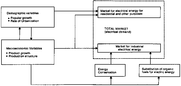
Figure 5-3
METHOD FOR DETERMINING WATER DEMAND FOR HYDROELECTRICITY
a) Method for determining electricity demand
b) Method for determining water demand for electricity generation
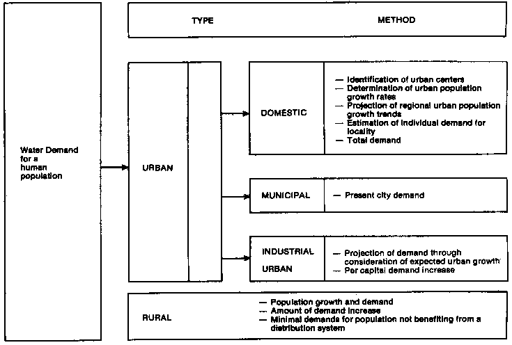
Figure 5-4 - METHOD FOR DETERMINING WATER DEMAND FOR HUMAN USE
The results of these special studies indicate interrelationships with other interests and activities, which can be positive (benefits) or negative (conflicts). It is not always possible to quantify the costs associated with these interrelationships, so, many times, indices are used to illustrate the activities and socioeconomic organization affected. These studies can provide the basis for selecting the best area for more detailed studies, the best project sequence for developing a watershed, and the best solution to meet a selected goal. Nevertheless, this information is still preliminary, and the planner must deal with such problems as choosing between diverse watersheds; defining the project sequence to meet diverse demands; comparing alternative investments (such as thermoelectric energy); considering projected demand and future water supplies as given when the risk that demand will not be met always exists; and defining the level of acceptable deficit cost risks for the lender.
Taking all of this into account, the planner comes to understand the balance between the potential water projects and the demands for water and arrives at alternative project sequences, each one with its respective costs and interrelationships with other projects and interests.
Figure 5-5 - METHOD FOR DETERMINING AGRICULTURAL AND LIVESTOCK WATER DEMAND
Figure 5-6 - METHOD FOR DETERMINING INDUSTRIAL (non-urban and non-mining) WATER DEMAND
Table 5-8
INVESTIGATION STAGES OF A WATER PROJECT
|
STAGES |
OBJECTIVE |
|
1. Office Evaluation |
The first evaluation of the project possibilities; the number of localities where dams can be constructed and the cost of research to be conducted in subsequent project stages. |
|
2. Prefeasibility |
Evaluates the development potential of the entire watershed, studies the diversion of the available falls in the rivers and estimates the costs of each project. |
|
3. Feasibility |
Completely defines the physical characteristics of the project and studies its financing and economic aspects. |
In practice, however, this process does not occur in an integrated form for all water uses. Usually, subsector plans are developed respectively for electricity, water supply, irrigation, etc. Projects are formulated that best meet the subsector objectives; competing interests are considered to be obstacles and are therefore ignored.
During the beginning of the planning phase, primary conflicts can be identified among the various interests intent on exploiting water resources. As the water project develops, other conflicts of interest usually appear - some between the consumers of the water product and others among those to be affected by the project's implementation. Others are provoked by hydraulic project construction and water resource management. The conflicts may be technological, social, economic, or institutional; they may occur from causes as wide-ranging as flooding, erosion, the dilution and transport of pollutants or the project's effects on climate.
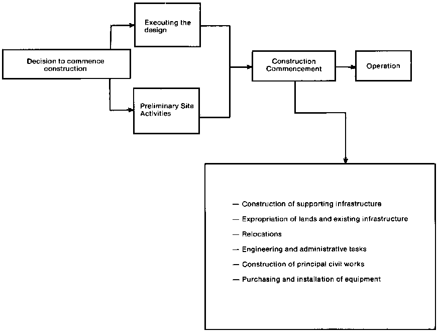
Activities at every stage of a project interact with other interests both at the site or far away. For example, making a decision to proceed with a project immediately influences the prices of land, the availability of investors, and whether people will stay in the area or leave. Preliminary design activities at the site also directly affect the vicinity where construction will take place. Executing the project profoundly affects the construction area, as well as other interests outside it. Although most of these impacts have a positive economic effect on the community many can be less beneficial (Tables 5-9 and 5-10 illustrate, in percentage terms, the average cost of 12 hydroelectric plants constructed in Brazil, giving a clear illustration of the direct economic impact of project construction).
Figure 5-7
FLOWCHART FOR PREFEASIBILITY AND FEASIBILITY STUDIES
FINAL STUDIES

Big projects require large numbers of workers and follow time schedules which can last up to 10 years. The workers may come from other regions in the country, bringing their families with them when possible. They will certainly have an impact on the local culture, and may also bring with them transmittable diseases previously unknown in the project area.
Other problems are associated with the interruption of economic activities (particularly farming and grazing), the relocation of populations, and the pressures placed on infrastructure. Some landowners will have their lands expropriated and will be relocated to new sites, which will require the construction of new towns to support them and their work. People living in rural areas along the rivers may lose their homes when rivers rise because of a new dam. The area to be filled will have to be cleared and its fauna and archaelogical resources relocated.
Table 5-9
AVERAGE COST PERCENTAGES OF HYDROELECTRIC PLANTS WITH DAMSa
|
Average Cost of 12 Plants |
% |
|
Expropriation of lands and infrastructure |
5 |
|
Relocations |
3 |
|
Principal civil works |
40 |
|
Equipment |
25 |
|
Supporting infrastructure |
9 |
|
Engineering and administration |
18 |
|
Total |
100 |
a. Constructed in Brazil.
Source: ELECTROBRAS (1982a).
Table 5-10
AVERAGE COST PERCENTAGES OF HYDROELECTRIC PLANTS WITH DAMSa (In terms of basic Investments)
|
Average Cost of 12 Plants |
% |
|
Expropriation of lands and infrastructure |
5 |
|
Labor |
31 |
|
Construction materials |
23 |
|
Permanent and construction equipment |
37 |
|
Transport of materials and equipment |
4 |
|
Total |
100 |
a. Constructed in Brazil.
Source: ELECTROBRAS (1982b).
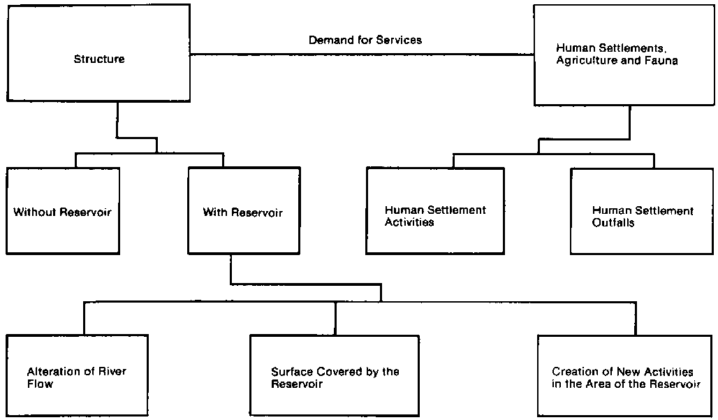
To illustrate both process and problems, Figure 5-8 describes the steps required to develop a hydraulic work designed to provide water for various purposes: public water supplies, industry, non-urban and mining enterprises, livestock and agriculture, hydroelectric energy, nutrient transport, navigation, habitat for aquatic fauna, recreation, and tourism, and flood control; Figure 5-9 presents a simplified illustration of the interactions between a hydraulic work, its services, and the settlements to which the services are directed and gives a brief picture of the categories of problems that the planner must consider and resolve before approving construction.
Hydraulic works that do not include dams create less negative impact in areas such as the Central Selva that have abundant water, especially when the water being used comes from rivers with large falls. Problems associated with supplying water to neighboring towns or to agriculture and livestock operations can also be minor, since the quantity of water involved is small when compared with the volumes found in area rivers. Although the expropriation of lands at the project site can cause significant difficulties, lands neither upstream nor downstream from the site are negatively affected because river hydraulic regimens are not affected.
The services provided by the project to human settlements naturally represent an entirely positive impact. On the other hand, the settlements can negatively affect both rivers and hydraulic works that serve other settlements, causing water pollution and sedimentation caused by soil erosion. The small size of this type of work prevents it from resolving problems caused by natural conflicts, such as floods or droughts.
Generally, hydraulic works with dams cause the most notable impact on the human and natural environment. This is true not only of large dams, but also of dams constructed in ravines. Small ravine dams can be used for several purposes, such as controlling erosion, reducing the impact of rising waters, raising low water tables, breeding aquatic species, enriching water with nutrients, and enabling water to be used for irrigation on hillsides. Care must be taken, however, not to cause the proliferation of diseases and mosquitoes.
Dams are capable of controlling the regimen of rivers, especially their low-water flows (large flow increases are usually only superficially controlled by dams). For example, the Puerto Prado Alto hydroelectric plant on the Tambo river, which has an average monthly low-water flow of 293 cubic meters per second (m3/s), can maintain, for one month, a flow of 727 m3/s. The 100-year flood, however, is eight times greater than the useful storage volume of the reservoir and the spillway must be designed in this case to accommodate 61,300 m3/s, for an error made in operating the spillway can cause large floods. Once every five years, the river's water flow increases at this location up to 16,000 m3/s. The project also is capable of altering hourly water volumes. It can change the volume passing through the turbines, increasing it to 50 percent more than the annual average.
Figure 5-8 - ACTIVITIES REQUIRED FOR DEVELOPING A WATER PROJECT
Another important function of dams is their capacity to trap sediments. This can cause two important changes: it can reduce the nutrients available to downstream fauna and flora, and increase the erosive capacity of the waters below the dam. Puerto Prado Alto is capable of trapping 62 percent of the sediments transported to the site.
The control of water flow and the trapping of sediments have both positive and negative consequences. For example, increasing minimum water flow facilitates downstream navigation; while reducing water flow reduces financial damage and loss of life downstream; reducing more frequent water flow increases, however, can adversely affect downstream agriculture dependent on them. Trapping sediments reduce the amounts deposited downstream, which can benefit navigation but can increase the erosive capacity of downstream water, and remove productive land along the original channel until a new soil equilibrium is attained; removing sediments increases the useful life of reservoirs downstream, but reduces the nutrients available to downstream fauna; and the erosive capacity of water used in operating the dam can affect the river's morphology downstream.
Figure 5-9 - INTERACTIONS CAUSED BY HYDRAULIC STRUCTURES
Thus, the operation of a dam can have a great impact on downstream conditions. Planners must, therefore, confront the problem of communicating this to people having an interest in downstream conditions.
Dams also are barriers that negatively affect fish, navigation, and population and ecosystems and, not only the dam, but the reservoir created by permanently flooding an area once covered with vegetation, can also create problems for many interests. Permanent inundations can eliminate forests, interrupt agriculture and livestock operations, and relocate human constructions and human and animal populations. The flooding can also damage the water quality in the reservoir itself. For example, decomposition of vegetation can alter the chemistry and biology of reservoir water. Decomposition commonly produces sulfuric acid and methane, both of which negatively affect equipment and aquatic life.
When high nutrient levels produce a proliferation of aquatic vegetation that increases the amount of decomposing organic material, more water is lost through evaporation, while the plants remaining in the reservoir can impede navigation, net fishing, and tourist and recreational use of the reservoir. Although such vegetation serves as a source of nutrients for fish, its presence conflicts with other uses. This unstable condition ends only after much of the vegetation is removed from the reservoir, a process that can require many years.
Human settlements and agriculture and livestock operations can also have a negative impact on reservoirs. Potentially significant can be bodily wastes, erosion that causes an increase in sediments and pollution that can transform reservoirs into sources of downstream diseases.
Problems do not only occur because of permanent inundation, but because of water volume fluctuations that cause the expanse of flooded areas to vary. For example, mosquitoes proliferate in areas that are uncovered following long periods of submersion, and people living alongside reservoirs can suffer difficulties when the distance to the water's edge increases during low water periods.
In the Puerto Prado Alto project 136 Km2 will be inundated, with the operating water level varying by 20 meters. Nevertheless, the energy production capacity of this inundated area is small compared with projects in Brazilian Amazonia. The index that illustrates the productivity expected of the reservoir, in this case electrical energy, shows the benefit that low-reservoir water levels can provide. On the other hand, it does not reflect that these energy benefits are probably destined for distant areas, while associated problems will occur both at the site and downstream from the reservoir.
Reservoirs can also cause significant temperature and atmospheric changes when conditions altered by watershed use are being reestablished. In the present case, these changes will not be great as the area has much available permanent water. Besides producing hydroelectric energy and controlling water volume, reservoirs can be useful for sport and commercial fisheries, trade, recreation, and tourism.
Man can also affect the services provided by water. For example, dams can alter rapids to change the types of boats normally employed in the area. Or problems can arise when there is no satisfactory way to distribute the new water supply and when water shortages result from water loss and improper water use. Such problems frequently afflict rural populations. Those people often, therefore, need to be educated in proper water use, especially when they are relocated to areas served by unfamiliar water systems.
Drainage works can also have a significant impact on ecosystems. Even when they do not include dams, they can alter hydrologic regimens and sometimes influence distant areas. For example, the Brazilian Pantanal de Mato Grosso buffers the effects of the high water periods of the Paraguay and Parana Rivers, which are not synchronous. Thus, while draining a swampy area can increase land available for agriculture, such action needs to be carefully analyzed to determine its impact both in the area and downstream.
Finally, it is important to mention some natural phenomena and their impact on hydraulic works. Some hydraulic works can partially control some natural phenomena, such as floods. Natural phenomena, however, can increase project costs. They can require increasing the size of drainage works to accommodate rising water, building dams to regulate low-water volumes, and strengthening structures to withstand seismic tremors.
When no hydraulic constructions exist on a river, the people living downstream believe natural disasters are sent from God. When a dam is built, however, it becomes the cause of all the problems. More than anything, this is a communication and education problem between those responsible for the project and those to be affected by it and intensifies the need for careful planning, with full participation of all the people who will build and benefit from the new waterworks.
(CEPIS) Centro Pan Americano de Ingeniería Sanitaria y Ciencias del Ambiente. 1980. Abastecimiento de agua a la población rural del Perú: Situación actual. Lima, April.
(ELECTROBRAS) Centrais Electricas Brasileras S.A. 1982a. Manual de estudios de factibilidad de aprovechamientos hidroeléctricos. Rio de Janeiro.
(ELECTROBRAS) Centrais Eletricas Brasileras S.A. 1982b. Manual de estudios de inventario prefactibilidad de aprovechamientos hidroeléctricos. Rio de Janeiro.
(ELECTROPERU) Compañía Nacional de Electricidad, Perú. 1982. Energía eléctrica y desarrollo; programa de acción.
Federal Republic of Germany. Sociedad Alemana de Cooperación Técnica (Misión Alemana). 1979. "Evaluación del potencial hidroeléctrico nacional." Plan Maestro de Electricidad. GTZ, Consorcio Lahmeyer (Saizzitter, LIS). Perú.
Federal Republic of Germany. Sociedad Alemana de Cooperación Técnica (Misión Alemana). 1981. "Expansión del sistema eléctrico del Perú." Plan maestro de electricidad. Perú. October 1980 and November 1981.
(ONERN) Oficina Nacional de Evaluación de Recursos Naturales. 1980. Inventario y evaluación nacional de aguas superficiales.
![]()
![]()
![]()
![]()