![]()
![]()
![]()
![]()
![]()
8.1. Project overview
8.2. Characteristics of the pilot project
8.3. Cadastral survey and land adjudication
8.4. Research on land redistribution needs
8.5. Financial analysis and assessment of farming systems
![]()
![]()
8.1.1. Objectives
8.1.2. Selection of the project area
8.1.3. Main components of the pilot project
![]()
The Pilot Project is designed to initiate, on an exploratory level, a programme of land registration and to carry out research on problems of land distribution in a specific area to allow detailed design of land redistribution activities. The basic premise of the project is that the land situation is a major constraint for a majority of the island's small farmers which can be eliminated or greatly reduced by a phased program of land transformation.
The Pilot Project has both national and local objectives. At the national level the project will:
- initiate land survey and registration activities planned by the Government, and- test the technical feasibility of a national programme of land redistribution.
Within the Project area, two local objectives are to:
- increase the security of tenure by providing title to all legitimate rural landowners, and
- study the feasibility of providing an adequate land base for as many small full-time farmers as possible.
The land survey and registration activities of the Project, although experimental in nature, can be considered by the Government as the initial step of the National Land Registration Programme. The training and experience gained in the Project area will support progressive expansion of survey and registration activities throughout the island. The land redistribution policy dimension of the Project is more limited, because of the technical complexity and political sensitivity of this question. The research to be undertaken will provide valuable information on the need for and mechanics of redistribution in the Morne Panache area. Implementation of a nationwide program will require serious political decisions regarding the future structure of agriculture in Saint Lucia.
Project objectives have been kept as simple and operational as possible, to avoid placing heavy demands on the local administration. Nevertheless, the multi-dimensional nature of the objectives may still give rise to certain implementation difficulties. At the local level, the provision of security of title for some may imply unsecured tenure for others, i.e., squatters and tenants. Concern for the rights of landless producers must therefore be incorporated into the Project, and research on the opportunities for creating new holders must be undertaken. A knowledge of these and other problems likely to be encountered and the testing of alternative solutions to them are among the main of the Pilot Project.
The area chosen for the Pilot Project (Map 8-1), is the Morne Panache farming community and the adjacent lands to the east, including the Bosquet D'Or and Glavier sections of the Government-owned Landco Limited.1 The area consists of approximately 1 300 acres on the south side of the Mabouya River in the Dennery Quarter. The main criteria used in selecting the project area were the following:
a) The area should exemplify problems of land registration whose solution will represent a valuable experience for future stages of the National Land Registration Program.b) There should be a land distribution pattern indicating a strong farming region, but with a severe land shortage for small, full-time farmers.
c) The area should have underutilized estate land that can be incorporated into small-farm production.
1 See Chapter 4, Section 4.2.2.
The Dennery Quarter was chosen over three suggested others (Gros Islet, Choiseul and Micoud), as a first approximation of a project region. The Gros Islet Quarter is of little importance agriculturally and is subject to pressures of urbanization and tourism that do not characterize other quarters to the same degree. The Choiseul Quarter is the most critical in terms of land demand but, given the scarcity of unused agricultural land, appears to offer little possibility for a successful pilot project within a reasonably short time.2 The Micoud Quarter is a strong farming region, widely known for its land disputes. A land survey in this region would be slow and costly, hardly a suitable setting for a project in which a survey is only the first of several stages involving research and evaluation of future activities.
2 Rojas, E., "Implementation of the National Transformation and Land Reform Policy in Saint Lucia, Second Part: Evaluation of the Pilot Project Area of Lafiette," OAS Technical Report, Castries, November 1980 (mimeo).
Saint Lucia - Pilot Project Area - Land Capability
Source: G.O.S.L. Natural Resources and Agricultural Development Project, O.A.S., Department of Regional Development
The Dennery Quarter, in contrast, has a larger proportion of small full-time holdings than the nation as a whole and contains Government lands (Landco Limited) that can be made available for redistribution. It is also located on a principal road 15 miles from Castries, facilitating project implementation without excessive exposure to urban influences.
Within the Dennery Quarter, two possible pilot areas were identified: the Morne Panache/Bosquet D'Or area to the south of the Mabouya River and the Derniere Riviere/Belmont area to the north. Both were sufficiently close to Landco lands that relocation of families needing land could take place without uprooting them from their communities. Closer examination revealed that much of the Government land in the Belmont area, while of satisfactory quality for small-scale farming, was already occupied by large numbers of squatters and small renters. This would have complicated the land redistribution research activities of the project and greatly increased the complexity of identifying land available for resettlement.
The Morne Panache area appears to be a more typical small-farm community, less dependent than Derniere Riviere/Belmont on the large estate as a source of wage income. While Government land in Bosquet D'Or offers somewhat less farming potential than in the Belmont area, it is relatively free of squatters and the available area is larger, permitting careful land use zoning prior to settlement.
The project area is delimited by the Mabouya River and one of its tributaries on the north and west, by the Glavier-Dennery road along a natural divide to the south and the boundary of the Bosquet D'Or and Glavier sections of Landco Limited to the east and southeast. These boundaries are sufficiently well defined to permit designation of the area as the registration block within the Land Registration Programme.
The pilot project has five main components, and each represented by a set of activities that will be performed sequentially:
i. Land survey and adjudicationa. Pre-adjudication dialogue with the community
b. Cadastral survey, land adjudication and title registration
c. Research and evaluation of the land adjudication and survey activityii. Research on land redistribution needs
a. Land distribution structure
b. Land demands and availability
c. Planning of land reconsolidation and redistribution activitiesiii. Reconsolidation of holdings
a. Increase in community awareness of opportunities arising from land reconsolidation
b. Land exchanges or purchases within the small-farm communityiv. Redistribution of land
a. Acquisition of land for redistribution
b. Zoning and planned subdivision of land
c. Resettlement of qualified farmersv. Expansion of the agricultural frontier
a. Identification of lands unsuitable for small farm agriculture
b. Project design of alternative land uses
Successful completion of the land survey and registration activity is a prerequisite to the initiation of subsequent activities. Difficult land disputes may drag on for years, but clear title must be determined for a majority of holdings before any meaningful evaluation of the need for reconsolidation and redistribution can be made. Once this evaluation is available, both of these activities can advance simultaneously. Consolidation of holdings within the existing farming community will to some extent reduce the need for redistribution of land outside of it. The release of existing farm land by families purchasing new, larger farms in the resettlement area will, on the other hand, provide new opportunities for reconsolidation.
In the short term, the pilot project will concentrate on activities (i) and (ii), which will provide information required to prepare specific projects on activities concerned with the reconsolidation of small holdings, land redistribution and expansion of the agricultural frontier. A detailed analysis and evaluation of these activities will be made in the following sections. Activities (iii), (iv), and (v) will have to be designed when the results of activities (i) and (ii) are obtained.
The main characteristics of the pilot project area will be described first to give a general background to the problems of land registration and redistribution likely to exist.
![]()
8.2.1. Land tenure and distribution
8.2.2. Present land use
8.2.3. Potential land use
![]()
The choice of a relatively small project area (approximately 1 300 acres) simplifies control over activities. Unfortunately, secondary data are generally not available at this level of disaggregation; the 1973/74 Agricultural Census and published data for the 1980 Population Census are only available at the quarter level.
Research by the Land Reform Management Unit of the Department of Lands and Surveys of the Ministry of Agriculture revealed four survey plans showing estates in excess of one hundred acres within the Project area (See Table 8-1). Two of these, Fournier (104 acres) and Theobald (163 acres), have been subdivided into smaller holdings.
TABLE 8-1. REGISTERED HOLDINGS IN PROJECT AREA, BY SIZE CLASS, NOVEMBER 1981
|
Holding size class |
Holdings |
Acreage | ||
|
(acres) |
(No.) |
(%) |
(No.) |
(%) |
|
0-1 |
0 |
0 |
0 |
0 |
|
1-5 |
10 |
27 |
19.9 |
2 |
|
5-10 |
9 |
24 |
58.0 |
6 |
|
10 - 25 |
11 |
30 |
161.2 |
18 |
|
25 and above |
7 |
19 |
680.0 |
74 |
|
Total |
37 |
100 |
919.1 |
100 |
Source: Information from the Department of Lands and Surveys, 1981.
The most significant inference to be made from Table 8-1 is the fact that no registered holdings of less than one acre are recorded, while the 1980 Farmer Survey shows 8 percent of the holdings in two communities of the study area as being less than one acre (see Table 8-2). This is probably the result of the expenses of deed and title registration under the current system, which prevents small farmers from properly registering their lands.
An analysis of holding sizes in these two communities is presented in Table 8-2. The Farmer Survey registration shows 152 holdings with a total of 699 acres, or 4.6 acres apiece. This area constitutes 77.7 percent of the estimated 900 acres in the pilot area, excluding Landco lands, and 54.6 percent of the 1 280 acres calculated to be within the total Project boundary.
Nearly 80 percent of these holdings and 60 percent of the land are in the 1.0-9.9 acre size categories, precisely those in which a large percentage of land-hungry full-time farmers are located. While this apparent need for more land satisfies one of the Project area selection criteria, the results must be qualified by observations of the Farmer Survey compared with the findings of the 1973/74 Agricultural Census (the latter shows only 51 percent of land holders in these size groups).
Secondary data sheds little light on land tenure in the Project area. Information gathered in the field indicates that, as in the Dennery Quarter as a whole, renting and sharecropping of small areas is common. Cases of boundary and ownership disputes were noted, which suggests that the Project area is no less complex than any other areas of a similar size.
Taking into consideration this underestimation and the fact that some holdings exist on Project land outside the Morne Panache and Dubonair communities, the total number of holdings to be considered will probably approximate 200.3
3 While the number of squatters on Landco land is known to be large, observation suggests that they do not occupy a significant area in the Bosquet D'Or and Glavier sections.
Data on land use collected by the 1980 Farmer Survey are restricted to an estimate of the plants and trees destroyed by Hurricane Alien. Because banana tree losses reached an average of 98 percent, statistics given for this crop can be taken as the total before the hurricane. Using survey data, it can be estimated that in 1980 the Morne Panache and Dubonair areas contained 430 000 banana trees, covering approximately 358 acres (at 1 200 trees per acre).4
4 This density, rather than the recommended density of 800 trees per acre, is used here for conversion to area because of the observed lack of pruning and resultant thicker tree stands.
Field observation reveals that coconuts and food crops are widely grown, but bananas are clearly the dominant income source. A systematic point sample of land use in the central portion of the Project area (excluding part of the Morne Panache and the Landco Limited lands), based on 1981 air photos, reveals the land use structure highly dominated by bananas and tree crops and other trees (see Table 8-3). Land tenure situations likely to be encountered in the project area include:
a) Individual owner-operator, with or without deed and survey of the land.b) Co-owner of family land, with or without documentation.
c) Occupant with consent of owner but without rent payment.
d) Tenant (renter, sharecropper, lessee) with payment in cash or kind, with or without a fixed lease period.
e) Squatter with prescription rights (30 years' permanence on land).
f) Squatter with no legal right to the land he works.
TABLE 8-2. RECORDED HOLDINGS IN PROJECT AREA BY SIZE CLASS; DISTRIBUTION IN TWO FARMING COMMUNITIES, 1980
|
Holding size |
Morne Panache |
Dubonair |
Total |
|||||
|
No. of holdings |
Area (acres) |
No. of holdings |
Area (acres) |
No. of holdings |
% |
Area (acres) |
% |
|
|
0.0 - 0.9 |
8 |
3.45 |
4 |
2.25 |
12 |
7.9 |
5.70 |
0.8 |
|
1.0 - 4.9 |
71 |
165.50 |
16 |
39.50 |
87 |
57.2 |
205.00 |
29.3 |
|
5.0 - 9.9 |
30 |
186.75 |
4 |
20.50 |
34 |
22.4 |
207.25 |
29.7 |
|
10.0 - 24.9 |
7 |
73.75 |
9 |
119.00 |
16 |
10.5 |
192.75 |
27.6 |
|
25.0 |
2 |
62.25 |
1 |
26.00 |
3 |
2.0 |
88.25 |
12.6 |
|
|
118 |
491.70 |
34 |
207.25 |
152 |
100.0 |
698.95 |
100.0 |
Source: 1980 Farmer Survey.
An individual may have access to land through a combination of two or more of the above situations. Individual or multiple plots of land may be involved. When the land is not owner-operated, the owner may reside in the neighbourhood, elsewhere in Saint Lucia, or overseas. Such land may even be Crown Lands, with or without the Government's knowledge.
Disputes will typically arise over property boundaries or ownership of land. The latter will involve claims of individual ownership, claims to a share of family land, or prescription rights through squatting. The data underestimate the number of extremely small (0.0-0.9 acre) holdings and those with 25 acres or more. To the extent that this is true in the Project area, the proportion of small (1.0-9.9 acre) holdings and the area they control will be relatively smaller.
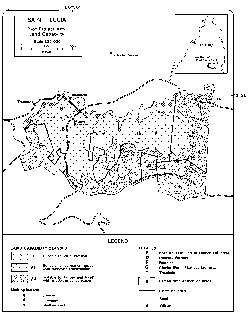
An analysis of land capability classes shows that nearly all the land in the project area is marginal, particularly that in large estates (Class IV or poorer). Yet much of it is intensely cultivated by small holders.5
5 See Annex A, sections A.3 and A.5 for description of and data on land capability in the country.
TABLE 8-3. LAND USE STRUCTURE, PILOT PROJECT AREA
|
Land use |
% |
|
Roads and urban areas |
2 |
|
Annual crops |
4 |
|
Coconuts |
15 |
|
Bananas |
28 |
|
Tree crops and other trees |
23 |
|
Secondary scrub growth |
24 |
|
Grass and pasture |
3 |
|
Total |
99 |
The distribution of private and state land by capability class is shown in Table 8-4. The location of the land capability classes is shown on Map 8-1. Highly productive land (classes I, II and III) constitutes only 10.9 percent of the Project area. These are valley lands located immediately south of the Mabouya River. Hillside land is divided between Class VI, where continuous farming is possible as long as the necessary conservation measures are taken, and Class VII, where permanent cover (for example, tree crops) is recommended. Part of the Class VII land is unsuitable for small farm agriculture.
The land available from Landco Limited is predominantly Class VII, which means that only part will be suitable for redistribution purposes. The remainder will be set aside for permanent forest cover or special large scale agricultural projects.
TABLE 8-4. LAND CAPABILITY CLASSES IN THE PILOT PROJECT AREA (acres)
|
Capability class |
Private |
Landco |
Total |
% |
|
I |
60.2 |
26.2 |
86.4 |
6.7 |
|
II |
23.2 |
12.3 |
35.5 |
2.8 |
|
III |
|
18.5 |
18.5 |
1.4 |
|
VI |
616.1 |
49.2 |
665.3 |
52.0 |
|
VII |
200.8 |
273.6 |
474.4 |
37.1 |
|
Total |
900.3 |
379.8 |
1 280.1 |
100.0 |
Source: Pretell, O., "Land Resources in Saint Lucia," OAS Technical Report, Washington, 1982 (unpublished).
![]()
8.3.1. Title registration
8.3.2. Essential procedures
8.3.3. Cadastral survey
8.3.4. Cadastral survey methodology
![]()
Of the three systems currently used to record the rights to and over land, that of registration of title is considered the most advantageous one.6 Its benefits are recognized by many countries but establishment has been delayed in many because of its technical requirements. One important requirement is the provision of plans (maps) of sufficient accuracy, in which every parcel can be clearly identified.
6 Mae, Leslie B., op. cit.
The other two systems are private conveyance and registration of deeds. The latter is currently in use in Saint Lucia. The shortcomings of private conveyance and of registration of deeds have been the subject of many discussions and reports. A comparative analysis of the various systems of land record and a review of the previous reports on this subject have been very effectively carried out by the Land Reform Commission, as is shown in the Interim Report of June 1980.
The system of registration of title, when competently established and efficiently operated, confers the following benefits:
a) An inspection of the register shows, at any time, the legal status of the land. Consequently, any person dealing on the evidence of the register need have no fear of eviction. Only the registered owner can dispose of his rights.b) All dealings in land can be carried out with security, expeditiously and at reasonable cost.
c) A registered land owner can borrow money quickly and easily on the security of his land.
d) Litigation over land is greatly reduced.
e) Absentee landlords and reversionary beneficiaries need have no fear that they will lose their rights.
f) The acquisition and holding of land by small proprietors is greatly facilitated.
g) Complete protection is given to persons who have restrictive rights over land, e.g., a right of way or water.
h) Absolute security is given to creditors who lend money on the security of land.
i) The administration of every public service and every branch of national activity connected with land is greatly assisted by the existence of an up-to-date and accurate map and record of land property throughout the country.
There are four main procedures for efficient registration of land titling, which will be followed in the Project area:
a) Definition of the parcels of land, the nature of the rights and interest affecting each parcel and the persons affected. Each parcel must be indexed by a unique number because confusion can result if the titles are indexed by using the owner's name. It is not unusual to find more than one person with the same or similar name.b) Title depends on the act of registration, not on the documentary instruments, but the creation, annulment and transfer of rights to land are affected by these instruments. Land transfer or interest in land by a certain party is not affected by the presentation of documentation until registration has occurred.
c) The working records must be kept accurate, safe and continuously cleared of out-of-date material. Protective duplication of the primary documents is the basic precaution ensuring the safety of the records. Duplication by photocopy or microfilm and safe storage is a relatively inexpensive insurance against the cost and confusion resulting from the destruction of a registry.
The primary function of the cadastral survey is to lay the foundation and satisfy the initial requirements of title registration. This is normally accomplished by dividing the country into registration sections, which are further subdivided into registration blocks. In the case of the Pilot Project, its entire area can be considered a registration section subdivided into three registration blocks. The objectives of the cadastral survey are as follows:
a) Definition of the procedures for assigning boundaries to parcels of land within the Pilot Project.b) Unambiguous location of parcels on the ground in a manner that permits easy relocation when necessary to the satisfaction of the courts.
c) Assurance that there are no gaps between, or overlaps of, the parcels.
d) Incorporation of all changes and consolidations as they occur.
By far the greatest source of litigation related to land tenure is the definition of boundaries. If boundary disputes are to be reduced to a minimum, the land to which entries relate must be clearly defined. A very convenient way to ensure such definition of units of land is to divide the region into blocks and to tie each block to the national grid.
i. Cadastral blocks
The use of cadastral blocks is an effective way of controlling both field and office compilation by dealing with small areas at a time. The most important working feature of such blocks is that they must be capable of being depicted in the plan as a whole on a single manageable sheet of paper. The maximum dimensions of the blocks on the ground are determined by the scale to be employed. There is some flexibility here, as both the sheet size and the scale can be varied to suit the local situation. Suggested scales for the Pilot Project area are 1:1 250 and 1:2 500. The use of cadastral blocks provides the following advantages:
a) It avoids the partial depiction of single parcels on two or more map sheets.b) It permits an orderly and permanent reference numbering of registered parcels to occur. This is especially important in the case of mutations.
c) It makes for the economical demarcation and location of the land parcels by the systematic subdivision of the registration section.
ii. Grid ties
In the last decade some of the English-speaking Caribbean islands recognised the importance of tying all surveys to the national grid. To emphasize this importance a number of them have actually written this requirement into their legislation; such is the case of the British Virgin Islands, the Cayman Islands, Antigua, and the Turks and Caicos Islands. The vast majority, however, continue to carry out surveys in a haphazard manner. In some instances even when the survey is done in relation to important topographical detail such as rivers and roadways, these are not properly indicated; such problems have been frequent in Saint Lucia.
The importance of making grid ties cannot be overemphasized. A cadastral plan, apart from unambiguously defining the parcellation of land, should also provide the necessary information for the relocation of lost boundaries. Such relocation can best be accomplished if the surveyed lands are tied to the grid. Fortunately, in Saint Lucia the density of major and minor control grid points is such that ties can be made with little extra effort on the part of the surveyor. Another advantage of tying the cadastral plan to the national grid is that it can then be easily related to the existing topographic maps, making planning of land use and land development easier and less costly.7
7 The Directorate of Overseas Surveys has produced topographic maps sheets of Saint Lucia at 1:50 000 and 1:25 000 scales. Work is being carried out at present on 1:2 500 scale maps.
Regulation Number 5 (subsections 1 and 2 under Section 28 of the Draft Land Surveyors Act) implies that all future surveys in Saint Lucia will be tied to the national grid. This is a welcome change in the legislation and will greatly facilitate compilation of the index map for registration of titles. The process of compilation under the current system is most difficult and clearly identifies the shortcomings of an unstructured system of land titling and registration.8
8 Serieux, J. E., "Report on the Progress of the Map Index of Land Parcels in Saint Lucia from Available Government Records," Ministry of Agriculture, Castries, November, 1981 (mimeo).
iii. Control network
It is essential to have an adequate and dense supply of control stations to effectively execute the necessary grid ties. There are approximately 162 control stations uniformly distributed over Saint Lucia. Therefore, a reasonable assumption may be made that the existing control is sufficiently dense to allow ties to be made without great effort on the part of surveyors. However, there may be a need for further breakdown of the control in some instances. Within the Pilot Project area itself there is a need for such further control. This can easily be done by traversing along the existing roadways and tying the traverse to existing control. There are two control stations (92 and 127) within close proximity of the Project area.
It is the responsibility of the Lands and Surveys Department to maintain and extend the control, as necessary. The control stations might be adequate in terms of their numbers and density but they are not always adequately targeted. Stations must be beaconed and kept in place, and properly maintained to be fully utilized.
iv. Manpower resources
A review of the manpower available reveals that the implementation of a general cadastral survey of Saint Lucia will depend on the use of survey technicians operating under the general supervision of licensed land surveyors. Regulation 13 of the proposed legislation (Subsection 3 under Section 28 of the Draft Land Surveyors Act) allows for such a procedure. This new provision greatly facilitates the implementation of the cadastral survey in the Morne Panache Pilot Project area and also reduces the cost of surveying smaller landholdings.
The basic goal of the survey is to provide control of sufficient density to form a framework on which to base the compilation of boundaries. The actual location of the individual parcels will be done by use of conventional ground survey methods. The standard of accuracy obtainable will be determined by such factors as available personnel, methodological approach and the limitations imposed by terrain.
The cadastral operations will be carried out in the following stages:
i) preparation of an index map at an appropriate scale,
ii) field compilation,
iii) adjudication, and
iv) completion.
i. Index map
The Directorate of Overseas Surveys is preparing maps at a scale of 1:2 500 to cover all developed areas of Saint Lucia. The areas excluded from this mapping exercise are the rain forests of the South Central Section and the areas of Millet, Mount Gimie and Saltibus. If necessary, these areas could be included in the mapping without further photography. The 1:2 500 mapping will provide a natural base map for development of the index map.
At present all survey plans relating to definition of parcels and boundaries are kept at the Department of Lands and Surveys, where they are checked and approved by the Superintendant of Lands and Surveys and Commissioner of Crown Lands. A detailed search will be made at the Lands and Surveys Office to determine the existence of recorded surveys within the project area. These plans will be reduced or enlarged to a scale of 1:2 500 and compiled into an index map showing all registered and certified plans.9
9 Land Reform Management Unit staff have already commenced such work on a country-wide basis on the 1:25 000 scale maps that allows for a minimum mapping unit of 10 acres. See Serieux, J. E., op. cit.
ii. Field compilation
The next stage of the Land Titling and Registration activity is to publicise the programme in the Pilot Project area and proceed with the pre-cadastral dialogue with the community. This can be done by radio broadcasts and in publication newspapers. The latter method, of course, will be very limited in its effect, not only because of the problem of illiteracy but because quite a substantial proportion of the farming community speak only Patois, a French Creole dialect (53 percent of the banana farms' inhabitants are illiterate and 30 percent speak Patois alone).10 The Agricultural Extension Officer could disseminate information about the project through collaboration with farmers in the extension service programmes and through general dialogues with community leaders.
10 WINBAN Survey.
iii. Adjudication
The Land Adjudication Act 1981 (Draft Legislation) clearly establishes the process to be followed in defining the boundaries of, rights to, and interest in the various parcels of land. This legislation follows recommendations of the Land Reform Commission in order to provide a complete cadastral survey and the basis for the systematic introduction of title registration to land.
a. Adjudication order
In accordance with Section 3 of the Land Adjudication Act, the Minister may by order declare that he intends to adjudicate and register rights and interest in land within a specific area. The Minister has the right to amend or revoke the order. Once it is carried it is then published in the Gazette for public notification.
b. Appointment and powers of officers
Under Section 4 of the Land Adjudication Act, on or after the publication of an order the minister appoints an adjudication officer for the area. This officer may appoint demarcation, recording, and survey officers necessary for performing the duties and exercising the power imposed and conferred upon them by the Act. The officers involved in the adjudication listed below have the power to act on the behalf of minors and absentee parties.
Demarcation Officer: outlines the boundaries of each and every parcel of land whether it is the subject of a claim or not. All parcels must be accounted for including public roads, rights of way and other Crown Lands. The powers of the demarcation officer are:
He may divide the adjudication section into blocks which shall be given distinctive numbers or letters.
With consent of the interested parties, adjust the boundaries of any land in the adjudication section, reallocate the same to ensure more beneficial occupation thereof or to effect a more suitable subdivision thereof.
Make any reservation he considers necessary for the purposes of defining existing roads, pathways and drains.
The Survey Officer: has the overall responsibility to execute survey work as required by the adjudication process and the specific responsibility of completing the demarcation index map ensuring that all parcels have an identifying number.
The Recording Officer: will consider all claims to any interest in land and prepare a register of the rights and interests arising from these claims.
The Demarcation Officer or Survey Officer may, at any reasonable time, enter any land within the adjudication area for the purpose of demarcation or survey of any parcel and may summon any person who can provide information regarding the boundaries.
c. Claims and demarcation
Sections 5 through 15 of the Land Adjudication Act allows for the following procedures:
The adjudication area can be divided into sections, in keeping with the Registration Blocks previously mentioned, and each area may be given a distinctive name. The names of settlements in the Pilot Project area can be applied to these adjudication sections, e.g., Morne Panache, Dubonair.
The Adjudication Officer prepares a separate notice for each section with the following elements for claims and demarcation.
a) Specification as early as possible of the situation and limits of the adjudication section.b) Requirement of any person who claims any interest in land within the adjudication section to make a claim either in writing or in person or by his authorised agent according to law within the period, place, and manner specified in the notice.
c) Requirement of all claimants to land within the adjudication section to mark or indicate the boundaries of the land claimed, in such manner and before the date specified by the Demarcation Officer.
The Adjudication Officer must give the adjudication exercise full publicity in the most effective manner in order to bring it to the attention of all interested parties. At least seven days' notice of demarcation must be given before the demarcation exercise begins. Notice of the time and place at which the demarcation will begin is given and require that every claimant to indicate the boundaries of the land affected by his claim. It is the responsibility of each claimant to have his boundaries cleared.
iv. Completion of an adjudication record
The adjudication record, as specified in sections 18 to 24 of the Land Adjudication Act, consists of a form on each parcel of land showing:
a) The number and the approximate area of the parcel as shown on the demarcation map.b) Either 1) the name and description of the person entitled to be the registered owner of the parcel, with particulars of the manner of acquisition and any restriction on his power of dealing with it, or 2) the fact that the parcel is Crown Land. It is not unusual to find two people with the same name. Therefore, any information that will positively identify the person entitled, such as a National Insurance number, should be noted.
c) Particulars of any registrable right under the Registered Land Act, such as a lease, mortgage, charge, easement, profit or restrictive agreement affecting the parcel, together with the name and description of the person entitled to the benefit and particulars of any restriction on his power of dealing with it.
d) The name of the guardian of minors, people suffering from unsoundness of mind, or disabled persons for the purpose of adjudication.
e) A list of the documents, if any, produced to the Recording Officer and retained by him for the purpose of adjudication.
f) The date on which the form is completed.
When completed, the form will be signed by the Recording Officer and if possible, in the case of privately owned land, will include an acknowledgement signed by the owner of the parcel and by any person recorded as having an interest in the parcel. In this fashion the owner and every other claimant accept the record.
When the Adjudication Record of an adjudication section has been completed, the Adjudication Officer signs and dates a certificate to that effect. Notice is immediately given of the completion and of the place at which the adjudication record can be inspected along with the corresponding demarcation map.
Provisions allow for objection by any aggrieved person affected by the adjudication and demarcation exercise, provided that this objection is made within ninety days of the publication of completion of the adjudication record. After the expiration of ninety days, or the determination of all petitions, the adjudication records will become final.
The procedure for hearing disputes will normally be the same as those of a civil suit. The only exception is that the Adjudication Officer may admit evidence which would not be normally admissible in a court of law, use evidence from other claims contained in any official record, and call evidence of his own.
The Registered Land Act 1981 (Draft), following recommendations of the Land Reform Commission, provides for the systematic registration of title to land in Saint Lucia. Through systematic compilation, the following will be accomplished: definition of parcels, determination of rights and interested parties, and registration in a methodical manner and orderly sequence by sections, blocks and parcels throughout the island.
For the purpose of registering the title to land, a Registrar will be appointed. His responsibility will be to administer the Registry which will be established in Castries. For the purposes of the Morne Panache Pilot Project, however, the present Registry of Deeds will undertake the functions of the new Registry. The Registry as established by the Registered Land Act 1981 will contain the following components: a) 1) Land Register; 2) a registry map; 3) parcel files containing the instruments supporting existing entries in the Land Register and any plans and documents filed; 4) an application book in which applications are recorded and numbered consecutively as they are made at the Registry; 5) an index showing the names of proprietors of land, together with all leases and charges showing the number of the parcels in which they are interested, and 6) a register and file of powers of attorney.
The Land Register will consist of three sections in respect to each parcel:
a) Property section, containing a brief description of land or lease with reference to the registry map or filed plan, the number of the registration block, the reference number of the parcel, and other information relating to the parcel, such as its area.b) Proprietorship section, containing a full description of the proprietor and a note of any caution or restriction affecting right of disposition.
c) Incumbrances section, containing a statement of mortgages, charges, leases and other incumbrances.
![]()
8.4.1. Evaluation of the land registration experience
8.4.2. Analysis of land distribution problems
8.4.3. Institutional framework for project implementation
![]()
An evaluation of the multiple aspects of the land registration experience of the Pilot Project is required to design the National Land Registration Programme. While the full impact of the programme cannot be anticipated, several areas for research and evaluation can be identified:
a) The process of land ownership clarification will sharpen existing disputes and bring latent ones into the open. The ability of the adjudication system to deal fairly and efficiently with such disputes is essential.b) Producers in the Project area who have no claim to land or who are unable to produce satisfactory claims may find their position threatened by survey and registration. Alternative forms of access to land (lease agreements, etc.) may be required to avoid expulsion of these families.
c) Family lands are likely to present special problems for survey and registration. This institution serves an important social function in Saint Lucia, e.g., it discourages excessive fragmentation of land (implicit in the present inheritance laws) and provides access to land for many who could not otherwise afford it. Any change introduced by the Pilot Project should therefore be carefully evaluated.
d) Community involvement procedures and public information methods used in the Pilot Project need to be evaluated for their further utilization at the national level.
e) Land surveying methods, surveying team composition and procedures, map scales, indexing systems, and recording and duplicating methods tested in the Pilot Project area need to be appraised for their applicability and relevance to the National Land Registration Programme.
The experience gained in the Pilot Project will allow the Government to calculate the resources (human, institutional and financial) required to introduce the system of registration of title at the national level and to negotiate resources from lending or donor agencies to complement those that can be devoted to this programme from the Government's regular budget. In addition, by linking the knowledge gained concerning the land distribution problems existing in small farming communities with that concerning national agricultural development policies it will be possible to identify the basic land adjudication blocks and to set priorities for the execution of the land adjudication and cadastral survey activities. In this way, the long-term programme of land registration can be linked with short- and medium-term agricultural development goals.
Land survey and adjudication activities will provide a precise picture of the ownership and land distribution pattern in the Project area and permit the identification of small full-time farmers with too little land. This knowledge will allow for the design of specific projects aimed at amelioration of this situation including both reconsolidation of holdings within existing communities and redistribution of estate lands in the surrounding area. While closely related, the two activities need to be analyzed separately. Reconsolidation requires an initial analytical stage followed by a guided programme of exchange and land purchase.
i. Land shortage
The following variables must be taken into consideration in determining land shortage:
a) Predominant income source. Families who depend primarily on farming will be given priority in the programme.b) Productive capability of the land. This must be translated into classes of average income potential to allow determination of the amount of land needed to provide a target income for an average farm family.
c) Total area of land owned or controlled by each full-time farm family. The ownership of multiple holdings, whether in the project area or not, must be taken into consideration.
A comparison of minimum holding size (item b) and the area of land already owned (item c) will provide a first approximation of land shortage. Determination of the amount of family labour available and the intention to continue full-time farming will clarify the need for additional land and the ability to effectively work it. Investigation of the economic structure of small farms will allow a more precise definition of minimum holding sizes. Existing knowledge on the operations of small farmers does not allow a precise definition of this central decision making criterion.
ii. Reconsolidation by exchange and purchase
Several types of opportunities for reconsolidating holdings within the small-farm community will emerge once the survey and adjudication process has been completed:
a) Farmers with scattered plots may exchange land so as to reduce travel time and rationalize farming operations. Total holding size may remain unchanged.b) New land titles will activate the local land market, e.g., various properties owned by non-residents or farmers about to retire may become available. A special line of credit could be used to direct these sales, assuring that they serve to create as many new viable small units as possible.
c) Additional plots may become available as families who chose to buy larger areas of former estate land surrender holdings in the small farm community.
The precise conditions on which such a reconsolidation process can succeed are not known. Research is required to assess the amount of land involved, loan requirements for land purchases or compensation in exchange, the loan repayment capacity of farmers willing to undertake the reconsolidation, the extent to which reconsolidation may occur spontaneously if financing for land purchases is available, etc.
The success of this reconsolidation activity will depend, in large part, on a line of preferential credit at the disposition of Project management. In its absence, changes will probably take place to worsen the pattern of land distribution in the Pilot Project area. The security of carefully titled land may attract new buyers to the area, forcing land prices beyond affordability for the smallest farmers. Apart from this possibility, market forces will tend to favour larger local purchasers regarding competition to buy land, leaving behind the farmers who most need additional land. At best, reconsolidation will only solve part of the land shortage problem in the Project area. Redistribution of estate land may be required to further reduce this constraint.
iii. Land redistribution
An initial evaluation of land needs among Morne Panache and Dubonair farmers, based on the 1980 Farmer Survey, suggests that up to 300 acres may be needed in addition to land gained from the reconsolidation process. The objective of land redistribution in this case will be to make unused or underutilized land available to full-time small-farm families who are willing and able to work it.
Research should concentrate on an evaluation of the economics of land redistribution under conditions of extreme scarcity of good agricultural lands in the Project area and in most of the small farming settlements in Saint Lucia. The size of viable holdings, requirements of infrastructure, investment in soil conservation and field development, etc., need to be carefully explored to assess the feasibility and desirability of the whole undertaking.
The size of holdings should be determined in large part by the desired income level. To determine the size, the objective of full use of family labour is important, with recognition that some underemployment in settlements may be inevitable. The Project will attempt to define suitable farm enterprise combinations with regard to land resources and income potential classes.
Research activities will be initiated with the preparation of a land use zoning and subdivision plan for the area. Lands to be subdivided must be first classified into three general use zones: 1) suitable for small scale agriculture; 2) suitable for large scale special projects, and 3) compulsory permanent forest cover. Only lands in the 1) category will be subdivided for redistribution. Farm size will vary according to the quality of the resource base. Access to each holding from the place of residence of the prospective purchasers must be taken into account in the subdivision design. Access to new holdings is an essential condition for success. Analysis of project viability should consider that purchasers will probably not live on the farm but commute daily from a neighbouring village and that the commercial orientation of even the smallest farmers in the area requires access to markets.
Land purchase will not eliminate all the constraints facing the small farmer. The need for technical assistance, secure markets and production credit will assume greater importance once land constraints are removed. The project will identify minimum service support levels and special assistance requirements of farmers in the Project area.
iv. Expansion of the agricultural frontier
Land capability analysis within the Project area reveals the existence of lands which are unsuitable for small agriculture but have potential for certain unconventional production alternatives. Climate and/or soils seriously limit the growth of bananas and food plants but certain tree crops may produce satisfactorily. The long gestation period to bring these crops to maturity, the need to introduce new production technology, and the relatively low value/acre/year (implying the need for large acreages) discourages many potential investors.
To encourage the Government and private entrepreneurs to initiate experimentation and productive investments on these lands, the Pilot Project proposes to: 1) conduct a natural resources inventory of the area, 2) identify commercial crops appropriate for its natural environment and an existing market, and 3) undertake an initial evaluation of their feasibility.
The information gathered will assist in the design of experimental farming of alternative crops for these lands. As estimated, 23 000 acres of such lands exists in Saint Lucia and a major part of it could be brought under extensive production.
It is estimated that the cadastral survey and land adjudication in the Pilot Project area can be implemented within a period of four months from the moment the survey and adjudication teams begin field activities. Preparatory work with the community and compilation of registered surveys that must be undertaken prior to the field work are not included in this time frame.
The executing agency of the Pilot Project will be the Ministry of Agriculture through the Land Reform Management Unit, established with the purpose of implementing the Land Registration Programme and the land redistribution policies of the Government. Full involvement of the Department of Lands and Surveys, also of the Ministry of Agriculture, is contemplated in the preparation of the cadastral survey and maps. The Registrar of Lands will perform the registration activities in the Pilot Project and serve as the institutional core for the new Registry.
As a result of the work undertaken by the Government through the Land Reform Commission, four interrelated legislative acts have been drafted and are currently being considered for approval. These are: 1) Registered Land Act, 2) Land Surveyors Act and Survey Regulations, 3) Land Adjudication Act, and 4) Agricultural Small Tenancies Act. This legislation needs to be approved by the House of Assembly before the Project teams initiate field work.
![]()
![]()
Pilot Project costs are estimated on the order of EC$365 781 (US$136 485).11 Estimates of personnel requirements and expenditures for field operation are presented in Table 8-5 for a four month period for the land titling and registration activity. The Pilot Project is now under way and consequently actual staff and costs may vary from the estimates shown.
11 1 US$ = EC$2.68 at December 1981 prices (when project was designed.)
Of the aforementioned EC$254 981, a total of EC$60 000 is already in the 1981 Government Budget and will be devoted to the purchase of land surveying equipment for the Project. The balance of EC$194 981 remains to be grant funded.
In addition to the EC$194 981, an amount of EC$171 600 should be funded in order to implement the research activity. Thus, the total unfinanced Project costs are EC$366 581, or US$136 783.
Of the of EC$171 600, EC$118 800 (US$44 328) would be devoted to defraying the expenses of senior research staff and the remaining EC$52 800 (US$19 701) to covering auxiliary staff, transport, office space and supplies.
The research effort requires four senior specialist months in each of the following fields:
a) Agricultural economist with farm management and/or land economics orientation;
b) Rural sociologist or cultural anthropologist with field experience; and
c) Field agronomist with farm systems and crop diversification experience.
TABLE 8-5. PILOT TITLING AND REGISTRATION PROJECT PERSONNEL REQUIREMENTS AND EXPENDITURES FOR FIELD OPERATION (FOUR MONTHS)
|
Personnel or project component |
EC$ |
EC$/month | ||
|
Managerial staff |
26 000 |
6 500 | ||
|
A. Field staff |
|
| ||
|
|
2 Surveyors |
10 400 |
1 300 | |
|
|
2 Survey technicians |
6 000 |
750 | |
|
|
4 Chainmen |
6 400 |
400 | |
|
|
12 Labourers |
16 800 |
350 | |
|
|
1 Driver |
2 080 |
520 | |
|
Labour overhead costs |
14 690 |
- | ||
|
Subtotal A |
56 370 |
| ||
|
B. Office staff |
|
| ||
|
|
3 Draughtsmen |
8 700 |
725 | |
|
|
1 Secretary/typist |
2 900 |
725 | |
|
|
Labour overhead costs |
3 240 |
- | |
|
Subtotal B |
14 840 |
| ||
|
C. Equipment |
|
| ||
|
|
2 Theodolites |
25 000 |
- | |
|
|
1 Electromagnetic Distone |
|
| |
|
|
Measuring equipment, e.g., |
|
| |
|
|
Guppy with set of triple reflectors |
25 000 |
- | |
|
|
2 Compass theodolites (Wild T 0) |
12 000 |
- | |
|
|
2 Steel tapes (80 meters) |
1 100 |
- | |
|
|
2 Electronic calculators |
1 056 |
- | |
|
|
|
- Boundary marks |
5 000 |
- |
|
|
|
- Drawing tables and stools |
2 000 |
- |
|
|
|
- Miscellaneous (ranging rods, etc.) |
2 000 |
- |
|
Subtotal C |
73 156 |
- | ||
|
D. Transportation |
|
| ||
|
|
1 Land Rover 4 WD |
45 000 |
- | |
|
E. Adjudication and registration |
|
| ||
|
|
- Adjudication magistrate, 4 months fee |
7 000 |
1 750 | |
|
|
- Registrar |
7 000 |
1 750 | |
|
Subtotal E |
14 000 |
| ||
|
F. Office rental (6 months) |
4 800 |
1 200 | ||
|
Summary |
|
| ||
|
|
Chief surveyor |
26 000 |
| |
|
|
Field staff |
56 370 |
| |
|
|
Office staff |
14 080 |
| |
|
|
Equipment |
73 156 |
| |
|
|
Transportation |
45 000 |
| |
|
|
Adjudication and registration |
14 000 |
| |
|
|
Office rental |
4 800 |
| |
|
|
10% unforeseen expenses |
20 815 |
| |
|
|
Total |
254 981 |
| |
On strictly financial considerations it appears that the estimated surveying, titling and registration cost of approximately EC$85 per acre is within a reasonable range and affordable by the farmers themselves. It can be anticipated that land with clear title would bring a premium price, higher than current market prices by at least this amount. The productivity gain, 15 percent of net returns of banana production, would cover this expenditure in one year.
No holdings of less than one acre are registered at present time while the 1980 Farm Survey indicates that a full 8 percent of farmers in the area (Morne Panache, Dubonair) fall in that category. It is likely that the expense of deed registration under current legislation is far too high in proportion to land value. Assuming net return of EC$500/acre of bananas, the expense of the Pilot Project seems well within reasonable boundaries.
Current land use intensity has created concern over steep hillside farming in Saint Lucia. However, the multi-canopied production system present in the Pilot Project area (e.g., bananas, coconuts, dasheen) seems sufficiently protective of topsoil. This cropping pattern is standard throughout the country, although it may be more effective in the northern part of the island, which has older soils and a more well-developed soil profile, than in the south, where skeletal soils and igneous aggregates are more common.
The many unanswered questions regarding appropriate and sustained land use will be best answered by an analysis of farming systems and their relationship to farm size and land tenure patterns. The existence of a titling programme and a cadastral survey should provide a unique opportunity for investigating the technology of hillside farming systems and making a contribution to sound environmental management and utilization.
In accordance with the typology of human settlements prepared by the Project the Morne Panache area corresponds to settlements where there is a concentration of small farmers producing crops that enjoy the most reliable market system (bananas, coconuts, fresh vegetables).12 The area receives good rainfall and contains soils not easily eroded and a higher percentage of holdings in the 1-5 acre and 5-10 acre categories.
12 See Carnegie, C., op. cit.
The following rural settlements are considered similar to the Pilot Project area in accordance with the criteria outlined above:
1. Babonneau
2. Balata
3. Paix Bouche
4. Chassin
5. Forestierre
6. Ti Rocher (Castries)
7. Guesneau
8. Bogious
9. La Gare
10. Cacoa
11. Marquis
12. Fond Cannie
13. Bocage
14. Trois Piton
15. Marc
16. Ravine Poisson
17. Odsan
18. Deglos
19. Barre de L'Isle
20. Fond Petit
21. Derniere Riviere
22. Au Leon
23. La Ressource
24. Morne Panache
25. Grande Ravine
26. La Caye
27. Saint Joseph
28. Micoud
29. Ti Rocher
30. Blanchard
31. Desruisseau
32. Degard
33. De Mailly
34. Ti Riviere
35. Mahaut
36. Morieux
37. La Cour Ville
38. Seleau
39. Choco Mel
40. Praslin
41. Patience
42. Mon Repos
43. Mamiku
44. Raillon
45. Lumbard
46. Durocher
47. L'Eau Mineur
48. Galba
49. Latille
50. Grace
51. Woodlands
52. Belle Vue
53. Banse
54. Canelles
55. Vige
56. La Rue
57. Annus
58. Giraud
59. Londonderry
60. Saltibus
61. Millet
62. La Croix Maingot
Of the 131 settlements identified (see Chapter 1), 47 percent, comprising 30.5 percent of rural households, have characteristics similar to those of Morne Panache. Consequently, the experience to be derived from the Pilot Project area should be an applicable and operational procedure replicable in close to half of the island's communities.
A substantial number of the benefits from the two Pilot Project activities of land title registration and research for land redistribution are indirect and external to the Pilot Project itself. The major indirect benefits that can be singled out at this time include the following:
a) Field operation experience with land titling and registration procedures.b) Understanding of the internal farm organisation of hillside farming on a variety of soil types.
c) Development of farm economics models and management recommendations compatible with sound conservation.
d) Better knowledge of the land redistribution needs of small farming communities and the best ways of implementing specific projects.
The Pilot Project area covers 1 300 acres (500 hectares). Land cadastre and registration activities cost EC$85 per acre, excluding management costs and vehicle and equipment investment that can be used in the national cadastre survey. The land redistribution research activity will cover an estimate 200 farm-operator households with a total population of 1 100 inhabitants. Farm systems and household survey costs are estimated to be EC$43 per person exclusive of ordinary services paid by Project funds.
![]()
![]()
![]()
![]()