![]()
![]()
![]()
![]()
![]()
2.1. Land tenure
2.2. Land distribution
2.3. Land use and technology
![]()
Land tenure and distribution are key factors to understanding the structure of production and power in Saint Lucia's rural sector. The following analysis is an attempt to characterize man/land relations and indicates the extent to which these relationships represent major constraints on agricultural development. Many of the data used are drawn from the 1973/74 Agricultural Census. While this information is somewhat dated and has certain deficiencies, it remains the best available at the national level. It has been supplemented with recent survey data and field observations.
![]()
2.1.1. Land ownership and rental
2.1.2. Ownership and operation of the agricultural holdings
2.1.3. Family lands
![]()
Various forms of land tenure influence the stability of the rural sector. If large numbers of farmers have only temporary access to land (through short-term sharecropping agreements, for example), social problems are likely to be severe. The 1973/74 Agricultural Census indicates that 70.6 percent of all holdings were "owned or held in ownerlike possession." No less than 92.6 percent of the total farm area was held in this way, suggesting that the sector was reasonably stable in this respect. This classification apparently includes family land, an issue discussed at greater length below.
The next most prominent tenure category was that of renter, which represented 18.3 percent of total holdings yet controlled only 2.8 percent of the island's farmland, averaging 1.0 acre per rental unit. While not a major problem nationally, these small producers may present one in specific localities. In the census quarter of Castries, Vieux Fort, and Dennery they constitute 24.4 percent, 27.8 percent, and 43.9 percent, respectively, of all holdings.
Another dimension of land tenure, the relation between ownership and operation of the holding, can be evaluated indirectly from census data. This relation is important when considering any "land to the tiller" programme or when examining questions of absentee ownership.
One indicator of the gap between owners and those who work the land is the legal form of landholding. While 98.4 percent of all holdings were owned by individuals (civil persons), 26.5 percent of the land was held by nineteen corporations. Another indicator of this gap is the incidence of management by third persons (farm administrators). A total of 57 holdings of 50 acres or larger were so managed in 1973/74 representing 39.5 percent of total farmland in Saint Lucia.
A certain disparity of land tenure emerges from this analysis. While the majority of farmers own the land they work, which suggests a high degree of tenure stability, localized problems of small rental holdings and squatting exist. On the other hand, a small number of large owners control a disproportionate part of the national territory, but do not work the land directly.
Family land is inherited land held in common by the heirs. This important type of land tenure in Saint Lucia requires separate analysis. The concept of family land originates from the laws of intestate succession (death in the absence of a will), which provide that property be divided in equal shares among the surviving spouse and all legitimate children. 1
1 In the absence of a spouse and legitimate children, succession devolves to ascending, descending or collateral relatives. Illegitimate children succeed only in the absence of legal issue.
While each heir has the legal right to demarcate and subdivide his inheritance, few such subdivisions take place. On small holdings the process is frequently more expensive than the value of the land. On large holdings, where the size of the inheritance might justify the cost, land is frequently maintained intact through will provisions or by agreement of the heirs.
In the absence of official statistics on the extent of family land, estimates range all the way from 10 percent to 64 percent of total farmland.2 Because landholdings tend to be small, the number of producers will be proportionately larger than the area.
2 United Nations Food and Agriculture Organization, op.cit., pp. 20-29. FAO reports that questions on family land were included in the 1973/74 Agricultural Census, although nothing has been published and nothing referring to this question was found in the original census forms.
A recent survey of 245 rural holdings of 15 acres or fewer revealed that 104 of the parcels (42.4 percent) consist of family land.3 Analyses of four Catchment Area Surveys show the area of family land to vary from 1.9 percent to 70.5 percent of the region surveyed. The situation appears to be of little significance in some areas, especially where larger farms predominate, but can represent the major form of landholding in areas where small farms are numerous.
3 University of the West Indies and Mid-West Consortium for International Activities (U.W.I. - MUCIA), "The Economic Role of Women in Small Scale Agriculture: The Eastern Caribbean," Saint Lucia, 1981 (mimeo).
The family land system has been condemned by many land tenure specialists who have visited Saint Lucia. Foreman declared it to be "the greatest single factor responsible for the unsatisfactory state of the island economy."4 The disadvantages are:
a) Co-owners of family land seldom have a deed or other legal evidence of their right to the land.b) Lack of legal documents impedes the sale of land and makes it extremely difficult to obtain credit.
c) Investment is discouraged by the conventional right of all co-owners to harvest permanent crops grown on the land, whether they participate in their cultivation or not.
d) Since not all heirs are interested in actively farming the land, some areas are left unused or underutilized.
e) Over generations the increasing number of co-owners of a holding may reduce each individual claim to an area too small to farm.
4 Foreman, R.A., "Land Settlement Scheme for Saint Lucia," British Government Colonial Office, Castries, 1958, p. 15.
There can be no doubt that the informality of the registration procedure and lack of cadastral information are primary in a combination of factors that slow the transformation of present agriculture as a commercial subsector. The advantages of the family land system are that family land has served as a mechanism to avoid excessive fragmentation implicit in succession laws; that a significant proportion of the population has been guaranteed access to land, whether on a full-time basis or as a supplementary income source; that garden plots are often grown by estate and urban workers helping subsidize wages from large farmers and urban employers; and that for those who do not work the land themselves family land serves as a type of social security and place of future residence.
The problem associated with the "family land" tradition of multiple small plots farmed by one family is in fact a product of the succession laws. Fragmentation can become severe over generations. Census data, while probably understating the problem, suggest that only 11.7 percent of all holdings are composed of two or more parcels and fewer than half of one percent contain three or more.
Any major changes in the family land tradition, as proposed by Foreman and others, will inevitably have social and economic consequences. According to statistics presented in the 1975 FAO report, 43 percent of the holders of family land felt that this arrangement in no way prevented them from making proper use of the land and only 29 percent stated that they would like to abolish this form of tenure in favour of individual property rights.5 The local farm population must obviously be consulted and involved in the process of deciding on any proposed change to avoid social and economic disruption.
5 Op. cit., pp. 29-30.
![]()
2.2.1. Holding size categories
2.2.2. Fragmentation and centralization
2.2.3. Characterizing the land distribution problem
2.2.4. The landless population
![]()
The skewed nature of land distribution in Saint Lucia is readily visible and in many respects reflects the plantation/peasant system established by the colonial powers. While the change in monoculture (from sugar to bananas) has increased participation in cash crop production, no fundamental change in the land distribution pattern has resulted.
Tables E-1 through E-5, Annex E, characterize land holding patterns on the island. Many of the data are drawn from the 1973/74 Agricultural Census, but more recent information is used where available. The choice of holding size categories used in the analysis is based on initial observations of the function that land has for the various types of holders. Holdings in the 0.1 - 0.9 acre category average only 0.4 acres each (tables E-1 and E-2), which suggests that these plots have only a supplementary function as an income source. Farms in the 1.0 - 4.9 acre category average only 2.2 acres, which indicates that most of these producers still have considerably less land than 4 to 5 acres of good agricultural land considered necessary to fully employ the farm family using existing technology.6 Both of these categories can be considered subfamily holdings by this criterion, representing the level where the greatest land need will be found.
6 See Zadek, S., "Appraisal Report on Roseau Small Holder Resettlement Scheme," Government of Saint Lucia, Ministry of Finance, Central Planning Unit, Castries, 1980 (mimeo).
The adequacy of operator family labour in farming is used as a major criterion for determining the remaining size categories. The degree of dependency on wage labour, as given in the Census, helps separate family and commercial holdings (Graph 2-1).7
7 Calculated as the percentage of paid workers in the total labour force during the week prior to the Census (1973/74) within each holding size.
GRAPH 2-1. Paid Workers as a Percentage of All Workers by Holding Size (Acres)
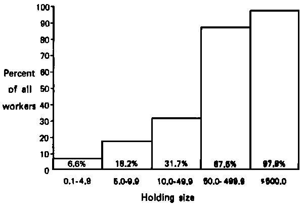
Source: Agricultural Census 1973/74
While some wage labour is recorded in the 0.1 - 4.9 acre category (assumed to be smaller than that necessary to fully employ the farm family), this is likely to be provided from earnings of family labour on larger farms, a variable not measured by the Census.
In the 5.0 - 9.9 acre category family labour provides over 80 percent of total labour requirements and only occasional outside workers are necessary. The 10.0 - 49.9 acre category can still be considered an essentially "family farm" situation, although purchased labour has increased to 31.7 percent of the total.
The situation changes radically for holdings over 50 acres. Census data show purchased labour as representing 74.4 percent of total requirements in the 50.0 - 99.9 acre category and 87.5 percent in the 50.0 - 499.9 acre category. These holdings can be defined as "commercial" with respect to labour use. The 500.0 acre category represents a qualitative rather than a quantitative distinction from other large farms because it is composed of the nineteen largest estates on the island. Labour on these farms is almost entirely purchased (97.9 percent).
Tables E-1 and E-2 of Annex E show that the smallest holding category represents 45.3 percent of all farmers, but contains only 2.4 percent of the area of farmed land.8 The 8,558 holdings in the 0.1 - 4.9 acre group (the two "subfamily" categories) represent 82.0 percent of all holdings yet control only 14.2 percent of total farmland. The 122 holdings with more than 50 acres represent only 1.2 percent of all farms but control 58.4 percent of the land. The largest nineteen holdings (+500 acres) alone contain 37.4 percent of the total area. This shows the inequality of land distribution to be severe, especially when land quality is considered.9
8 This percentage is a calculation of total holdings which includes 502 "Holdings Without Land". Actual percentage is 43.2 percent, as shown elsewhere in this report.9 In the quarter of Dennery it was found that up to 87 percent of the lands in classes I, II, and III were in holdings of over 500 acres and that large farms (over 50 acres) accounted for almost all the good lands available in the quarter.
Comparison by census quarter (Table E-1) shows an extreme concentration of micro-holdings (0.1 - 0.9 acres) in Castries (58.1 percent), Canaries (55.1 percent) and Gros Islet (52.8 percent). Where the subfamily categories (0.1 - 4.9 acres) in the quarters of Vieux Fort and Choiseul are considered jointly, they represent the most critical situation, with over 90 percent of all holdings falling within the 0.1 - 4.9 range. In only three of the quarters does the percentage fall below 80 percent. These figures indicate that inequality of land distribution in Saint Lucia is widespread.
The concentration of land ownership in large holdings (over 50 acres) is most severe in Gros Islet, Vieux Fort, and Anse La Raye, where it exceeded 70 percent of total farmland (Table C-2). Large estates (500.0 acres) occupy half of the land in Anse La Raye and Vieux Fort and 68.4 percent in Gros Islet. The area occupied by large holdings (500.0 acres) as a percentage of total area, by quarter, is shown in Map 2-1.
An attempt to rank the census quarters in terms of the severity of land fragmentation concentration is presented in Table 2-1.
The quarters are ranked by the percentage that each of the four land distribution situations represents of the total number of holdings (in the case of fragmentation) or area (in the case of concentration). For example, the Quarter of Castries had the largest percentage of holdings in the 0.1 - 0.9 acre size and was among the quarters with the smallest percentage of area included in the 50 acre category.
The "inequality index" is calculated by allocating weights for each quarter according to its rank (e.g., the index for Castries is 10 + 7 + 2 + 5 = 24), as shown in Table 2-2. The assumption is that each of the four situations is equally constraining and permits summation in a single index. Differences in the productive potential of the quarters were not considered. From the inequality index, quarters can be categorized into relative "degrees of severity" regarding the land distribution problem. Map 2-2 shows the distribution of the quarters according to three classes of severity.
To better qualify the severity of unequal land distribution, the problem can also be examined in terms of the function of land for the holder. The Census provides national data on the occupation of the landholder, permitting identification of those for whom agriculture is the primary occupation, those who work primarily as agricultural labourers on the land of others, and those who depend largely on non-farm employment. Wage labour in agriculture is found primarily (although not exclusively) on estates. Non-farm work includes fishing as well as urban jobs. These data are presented in Annex E, Table E-3.
Fewer than half of all landholders are full-time farmers. One of every three has a non-agricultural occupation and one out of six is an agricultural employee. The function of land as a supplemental income source is most pronounced in the smallest and the largest size categories. Only one-fourth of all holders in the 0.1 - 0.9 size category are self-employed farmers. Half of them have non-agricultural jobs, another one-fourth are rural wage workers. Over one-third of all holders included in the 1.0 - 4.9 acre category (most likely those with smaller plots) also depend on other occupations for their principal source of livelihood. Many of these part-time farmers probably work family land and grow subsistence crops in their spare time.
Map 2-1. Saint Lucia - Area of Holdings Above 500 Acres by Quarter, 1973/74
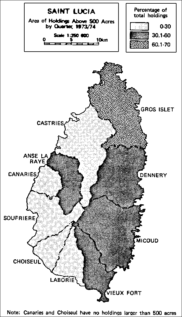
Source: Table E-2, Area of Holdings by Quarter and Size Category, 1973/74
TABLE 2-1. LAND FRAGMENTATION/CONCENTRATION RANKING BY QUARTERS, 1973/74
|
Rank |
Fragmentation a/ |
Concentration b/ |
||
|
0.1-0.9 |
0.1-4.9 |
50.0 |
500.0 |
|
|
10 |
Castries |
Vieux Fort |
Gros Islet |
Gros Islet |
|
9 |
Canaries |
Choiseul |
Vieux Fort |
Anse La Raye |
|
8 |
Gros Islet |
Gros Islet |
Anse La Raye |
Vieux Fort |
|
7 |
Choiseul |
Castries |
Canaries |
Micoud |
|
6 |
Anse La Raye |
Canaries |
Micoud |
Dennery |
|
5 |
Vieux Fort |
Soufriere |
Soufriere |
Castries |
|
4 |
Soufriere |
Anse La Raye |
Dennery |
Soufriere |
|
3 |
Laborie |
Laborie |
Laborie |
Laborie |
|
2 |
Dennery |
Dennery |
Castries |
Canaries |
|
1 |
Micoud |
Micoud |
Choiseul |
Choiseul |
a. Quarters ranked by numbers of small holdings as a percentage of total number of holdings.b. Quarters ranked by area of large holdings as a percentage of total area; 10 is the highest ranking (amount), 1 the lowest. Source: Annex E, Tables E-1 and E-2.
TABLE 2-2. LAND FRAGMENTATION/CONCENTRATION; ACTUAL RANKING, 1973/74
|
|
Fragmentation |
Concentration |
Inequality Index |
||
|
0.1 - 0.9 |
0.1 - 4.9 |
50.0 |
500.0 |
||
|
Gros Islet |
8 |
8 |
10 |
10 |
36 |
|
Vieux Fort |
5 |
10 |
9 |
8 |
32 |
|
Anse La Raye |
6 |
4 |
8 |
9 |
27 |
|
Castries |
10 |
7 |
2 |
5 |
24 |
|
Canaries |
9 |
6 |
7 |
2 |
24 |
|
Soufriere |
4 |
5 |
5 |
4 |
18 |
|
Choiseul |
7 |
9 |
1 |
1 |
18 |
|
Micoud |
1 |
1 |
6 |
7 |
15 |
|
Dennery |
2 |
2 |
4 |
6 |
14 |
|
Laborie |
3 |
3 |
3 |
3 |
12 |
Source: Table 2-1.
Map 2-2. Saint Lucia - Land Fragmentation/Concentration

Source: Table 2-2, Land Fragmentation/Concentration Actual Ranking, 1973/74
These findings indicate that land serves a social function for the small holder which differs significantly from that of the commercial farmer. Not only is emphasis placed on food crops, but the part-time small holder may, in some instances, be unable to work more land even if it were available.
The fact that fewer than half of the largest holders are self-employed in agriculture may be explained by their multiple roles as landlords and businessmen. Their principal occupation may change over time, depending on where the most profit can be obtained. Currently, however, agriculture appears unable to compete with commerce and urban land speculation.
There are numerous reports of the existence of a sizable landless population in Saint Lucia, although no precise data are available to quantify this assertion or to analyze its spatial distribution. When carrying out its hearings the Land Reform Commission received testimony on the question of squatting that indicated the existence of a large group of landless peasants. The Forest Supervisor reported the presence of squatters in the forest reserve and spoke of penalties and other efforts to alleviate the problem they posed. Errand, Louvet, and Jalousie states also reported intrusions from squatters in the past few years. Other estates, while claiming no problem with squatters, did comment on the prevalence of praedial larceny from their holdings. Several of the large estates submitted written statements to the Commission reporting that they allocate portions of land to their workers for planting gardens.10 This has been a long tradition of Saint Lucian estates that apparently continues to be widespread. The practice perhaps mitigates or disguises the problem of landlessness.
10 Saint Lucia Land Reform Commission, "Public Hearings 1979/80 Transcription," Castries, 1980 (mimeo); and "Written Memoranda Submitted to the Commission, 1979-1980" (unpublished).
Squatting is not assigned a specific tenure category in the Agricultural Census, nor is there any indication that it is included in the "other types of tenure" category. This may be attributed to the illegality of squatting and the reluctance of the squatter to provide the census enumerator with information.
"Landless" in the Saint Lucian context encompasses a variety of different relationships of people to land in the rural sector. There are people who rent land on a seasonal, yearly or long-term basis, squatters on privately owned or Crown lands, and people who operate holdings too small to provide an adequate income for their families without other forms of employment. These conditions can impose considerable insecurity of tenure on agricultural producers which restricts their productive potential. These effects might vary in severity from one farmer to the next or between one part of the island and another. Furthermore, land possession itself does not ensure the disappearance of unfavourable conditions. The difficulty of securing registered title to freehold property, the lack of price supports and adequate marketing arrangements for produce, the difficulty in securing agricultural loans, and several other conditions tend to constrain the farming community regardless of the form of tenure.
While renting and squatting indicate landlessness, not all renters and squatters are necessarily landless. In the Caribbean Research Development Institute (CARDI) sample of 31 Saint Lucian farmers, at least 5 of the 21 for whom information is complete show different forms of tenure on different farm plots in their holdings. A lease or rental may be combined with more secure tenure on freehold or family land.11 These forms of tenure have become part of the small farming system over time. In some instances they may represent a temporary phase in the farmer's working career, supporting him until he gains access to family land or takes up another occupation. In other instances, rental and leasehold may be used by the small farmer as a device for spreading risk.
11 Vasantha Narendran, op. cit.
The implicit assumption that when given access to land the landless will become long-term agricultural producers must also be carefully evaluated, particularly in connection with the age structure of this landless population. The existing information indicates that not all the rural population is equally willing to engage in full-time farming. Over the years, a pattern has developed in which young people below age 35 are under-represented in the local agricultural sector, but gradually take their place in agriculture during their middle years.12
12 Carnegie, C., op. cit., p. 33.
![]()
2.3.1. Uses of agricultural land
2.3.2. Intensity of land use
2.3.3. Land use and family land
2.3.4. Land utilization
2.3.5. The function of production
![]()
Various aspects of farming practices have been identified as constraints on land development and as justification for promoting a reformulation of the structure of the rural sector. Large farms are accused of underutilizing the land at their disposal. While land is used more intensely on small farms, its utilization is seen as technologically backward, resulting in a relatively low level of efficiency. The following analysis characterizes land use and technology in Saint Lucia's rural sector and suggests areas of constraints on production.
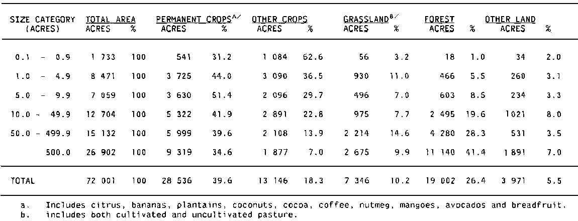
Land use by holding size is presented in Table 2-3. This analysis is based solely on 1973/74 Census data since the 1980 Farmer Register provides information only on the area of crops damaged by Hurricane Alien and not on total land use. The proportion of land in permanent crops (bananas, tree crops) is high for all size categories, averaging 39.6 percent. It is lowest for the smallest and largest holder categories and highest for the 5.0 - 9.9 acre size category. This activity is characterized by its permanence, providing land cover and protection against erosion year-round.
The production of other crops, primarily food provisions, shows a marked decrease as farm size increases. The smallest size category has (0.1 - 0.9 acres) over half of its area devoted to this activity, while on the largest farms (500 acres) 7 percent of the area is planted with annual crops. This suggests an essentially subsistence and non-commercial nature for these crops. They also provide the least protection against resource degradation because of their limited canopy and the seasonal nature of production. The second largest major-use class, in terms of area, is forest land, which increases with average farm size. Because there is little exploitation of forest on farmlands in Saint Lucia, this category can be considered unused land, as can the "other land" category in Table 2-3.
A summary of the three major land use categories, expressed as a percentage of total area, is useful for comparing the intensity of use by holding size. Table 2-4 shows percentages of land by size category. Cropland includes both permanent and annual (other) crops. Unused land is composed of forest and other land from Table 2.3. The intensity of land use is seen to be in inverse proportion to holding size, e.g., pressure on land in the smallest size category (0.1 - 0.9 acres) appears excessive, considering that most lands in this category are hillside farms requiring careful conservation measures. In the three smallest size categories (10 acres) over 80 percent of total area is used for crops. Cropland intensity drops to just over 40 percent on the largest farms (500 acres), lending support to the contention that the large holder uses his land less intensively than he might. Pasture area is much smaller on large holdings than might be expected and is probably even less today given the observed reduction in cattle production on large units during the 1970s.
TABLE 2-3. LAND USE BY HOLDING SIZE, 1973/74
Source: Ministry of Agriculture and Lands, Agricultural Statistics: Census Data, 1973/74, Castries 1975.
TABLE 2-4. MAJOR LAND USE BY HOLDING SIZE, 1973/1974
|
HOLDER SIZE (acres) |
AREA |
TOTAL AREA (%) |
CROPLAND (%) |
GRASSLAND (%) |
UNUSED (%) |
|
0.1 - 0.9 |
1 733 |
100.00 |
93.8 |
3.2 |
3.0 |
|
1.0 - 4.9 |
8 471 |
100.00 |
80.4 |
11.0 |
8.6 |
|
5.0 - 9.9 |
7 059 |
100.00 |
81.1 |
7.1 |
11.8 |
|
10.0 - 49.9 |
12 704 |
100.00 |
64.7 |
7.7 |
27.6 |
|
50.0 - 499.9 |
15 132 |
100.00 |
53.5 |
14.6 |
31.9 |
|
500.0 |
26 902 |
100.00 |
41.6 |
9.9 |
48.5 |
|
TOTAL |
72 001 |
100.00 |
57.9 |
10.2 |
31.9 |
Source: Table 2-3.
The implicit assumption that "unused" land on large holdings can in fact be farmed profitably would be contested by many owners involved. Most unused land consists of hillside forest or scrub. The rich alluvial valleys found on many large estates are generally being cultivated with permanent crops. Observation suggests, however, that were this unused land found on medium sized and small holdings, much of it would be under cultivation. Recent land sales by large estates, releasing unused land for agricultural purposes, tend to confirm this observation. The reasons for this difference in land use between holding sizes must be identified to determine how a "profitable" activity is defined by each holder type.13
13 For the large holder, the profitability calculation includes provision for a return on invested capital. The peasant farmer, on the other hand, will probably undertake production on land as long as he earns at least a wage equivalent for his labour even though little or nothing is left as returns on capital.
Analysis is required to ascertain the frequency of non-use of plots within small holder communities, information not apparent in the census data. The methodology of census enumeration explains why this situation is not documented: all holdings where no economic activity had occurred during the preceding twelve months were simply ignored for census purposes.
The proportion of family land claimed by holders who were actually farming in the survey of three catchment areas varied from 20.4 percent to 34.6 percent, which indicates that a major part of family land in these regions was not being worked (Table 2-5). While this limited information cannot be extrapolated to the nation as a whole, it does suggest that considerable unused land exists at both ends of the farm size spectrum, though for quite different reasons.
TABLE 2-5. FAMILY LANDS IN THREE SELECTED AREAS, 1972
|
|
Total family land |
Portion claimed |
% |
|
Chopin |
103 |
21 |
20.4 |
|
Micoud |
318 |
110 |
34.6 |
|
Vige |
687 |
189 |
27.5 |
|
TOTAL |
1 108 |
320 |
28.9 |
Source: Government of Saint Lucia, Ministry of Agriculture, Socioeconomic Survey of Three Catchment Areas, 1972.
Because no documentation of vacant lands exists, analysis of why land is vacant is tenuous at best. The explanation would partially appear in the family land arrangement, in which some co-owners live far from the land (perhaps even outside the country) and are not interested in working it. There are probably other limitations, e.g., physical, restricting the use of family lands for agriculture.
While it is not always easy to document the existence of unused land in the rural sector, the question of under- and overutilisation of land is even more difficult, but nevertheless important. The data above suggest that many small holdings are being utilised beyond what can be considered a rational degree of intensity, given the steep topography and the need for permanent vegetation cover over considerable areas of these farms. Both producer education and alternative employment will be necessary to reduce this pressure on the ecosystem.
Underutilization of particularly productive and ecologically stable soils such as the alluvial valleys is an important problem as well, especially from the point of view of national product and income. There are indications that these valleys are undercapitalized and underutilised today, which suggests that private profit calculation is not necessarily compatible with the national interest.14
14 This is the case with two large estates now controlled by the Government, Dennery Factory and Roseau Estates, where large investments in field development are required to make the properties productive.
In the absence of value or income data, crops grown by different holding sizes can be taken as a measure of the importance of its cultivation to the producer. For the two smallest holding sizes (0.1 - 4.9 acres), food crops are the most frequently grown and represent the activities in which the smallholder makes the greatest contribution to national production (see Graph 2-2).
As holding size increases, participation in food production decreases in favour of export and commercial crops. In the largest size category (500 acres), production is specialized in a small number of high-income crops (bananas, coconuts and limes).
Banana production for export is found on farms of all sizes, although only one-third of the holdings in the 0.1 - 4.9 acre categories produced any. This compares with over 60 percent of the holdings in the 5.0 - 9.9 and 10.0 - 49.9 size categories. The widespread distribution of this major cash crop among holding sizes can be explained by its relatively high income potential and the absence of significant economies of scale in production, given the existing level of technology. The lower participation of the smallest holdings may be due to their difficulty in gaining membership in the Banana Growers Association.
GRAPH 2.2. Contribution to National Food Production Made by Small Holders (0.1 - 4.9 acres)

Source: Government of Saint Lucia, Ministry of Agriculture. Agricultural Statistics, Census Data, 1973/74
![]()
![]()
![]()
![]()