![]()
![]()
![]()
![]()
![]()
I. Introduction
II. The natural resources inventory
III. The DELNO region study
IV. The Cibao region studies
V. Epilog
VI. Lessons learned
VII. Bibliography
![]()
PROBLEM SUMMARY
Building Integrated Regional Development Plans on National Resource Surveys - A Natural Resources Inventory and Development Action Plans for Subregions and a Region (Dominican Republic)
The Dominican Republic case study consists of accounts of three studies that were undertaken for different but related purposes between 1964 and 1980. The Natural Resources Inventory (1964-66) created a national resource data base for development planning, helped planners identify projects for immediate implementation, and enabled the Dominican Government to plan longer-range resource-development activities for resource-rich zones. Working with the Dominican National Planning Office on a US$350,000 budget, the study team developed integrated maps depicting vegetation, land use, hydrology, geology, soils and land capability, population distribution, and transportation networks. It proposed study projects in irrigation, drainage, flood control, crop diversification, and agricultural production, as well as research programs in mining development, underground water resources assessment, forest conservation, and national parks development. Recommended investments in studies and pilot projects totalled US$5,000,000.
The Development Action Plan for the Northwest Corridor (DELNO), the second study in the series, was conducted between 1973 and 1975 to help revitalize the regional economy and to create a regional planning model. The Department of Regional Development (DRD) helped the Technical Secretariat of the Presidency and the Ministry of Agriculture develop an action plan that featured 18 investment projects organized in four programs. Proposed investments totalled US$45,000,000 and focussed on forestry, mining, soil and water conservation, agricultural production, cattle research, agricultural extension and credit, irrigation, telecommunications, rural roads, education, cooperatives, and tourism.
The third study (1978-79) was designed to create a general development strategy for the Cibao Region and a more fine-tuned strategy for the Eastern subregion within Cibao. Working with the Dominican National Planning Office again and a US$518,600 budget, DRD proposed 130 investment projects in agriculture, forestry, mining, agro-industry, water resources, tourism, resource conservation, social services, and road-building for the 5,300 km2 subregion. These were tied via policy and institution-building proposals to the social, economic, and spatial development strategy.
DOMINICAN REPUBLIC - NATURAL RESOURCES INVENTORY- Fact Sheet
|
Project area: |
48,442 km2 |
|
Population: |
4,006,405(1970) |
|
Duration of Project: |
Preliminary Mission: 1964 Fieldwork: 1/1965-5/1966 Publication of Final Report: 1967 |
|
Technical contributions: | |
|
DRD disciplines |
Number of DRD Experts |
|
Geographer (Project Chief) |
1 |
|
Cartographer |
3 |
|
Forest Engineer (vegetation specialist) |
1 |
|
Geologist |
1 |
|
Hydrologist |
1 |
|
Soil Scientist |
2 |
|
Transportation Engineer |
1 |
|
Population Specialist |
1 |
|
Total professional person-months: | |
|
DRD: |
Gov. of Dominican Republic: N.A. |
|
Fieldwork: |
33 |
|
OAS Headquarters: |
172 |
|
Financial contributions: | |
|
DRD: |
US$354,000 |
|
Gov. of Dominican Republic: |
US$50,000 |
|
Total investment in projects proposed: |
US$5,000,000 |
|
|
|
DOMINICAN REPUBLIC - DELNO REGION STUDY - Fact Sheet
|
Project area: |
9,562 km2 | |||
|
Population: |
650,229(1970) | |||
|
Physical characteristics: | ||||
|
- Holdridge life zones: | ||||
|
|
Subtropical | |||
|
|
|
Thorn woodland | ||
|
|
|
Dry forest transition zone to moist forest | ||
|
|
|
Moist forest transition zone to dry and wet forest | ||
|
|
|
Wet forest | ||
|
|
Lower montane | |||
|
|
|
Moist forest | ||
|
|
|
Wet forest transition zone to rain forest | ||
|
|
Montane | |||
|
|
|
Wet forest | ||
|
- Elevation range: Sea level to 3,175 m | ||||
|
- Land capability classification: | ||||
|
|
Arable soils: 52% | |||
|
|
Non arable soils: 48% | |||
|
Duration of Project: | ||||
|
|
Preliminary Mission: 1971 | |||
|
|
Fieldwork: 2/1972-12/1974 | |||
|
|
Presentation of Final Report (preliminary version): 2/1975 | |||
|
|
Publication of Final Report: 1977 | |||
|
Technical contributions: | ||||
|
DRD disciplines (22) |
Number of DRD Experts (35) | |||
|
Economist (Project Chief) |
1 | |||
|
Economists |
2 | |||
|
Agricultural Economist |
1 | |||
|
Agro-industry Specialist |
1 | |||
|
Agronomist |
2 | |||
|
Cattle Production Specialist |
2 | |||
|
Computer Programming Specialist |
1 | |||
|
Editor |
1 | |||
|
Education Specialist |
2 | |||
|
Forest Development Specialist |
2 | |||
|
Geologist |
1 | |||
|
Infrastructure Development Specialist |
3 | |||
|
Irrigated Agriculture Specialist |
1 | |||
|
Labor and Manpower Specialist |
1 | |||
|
Marketing Specialist |
1 | |||
|
Public Health Specialist |
1 | |||
|
Regional Planner |
1 | |||
|
Sedimentologist |
1 | |||
|
Soil Specialist |
4 | |||
|
Telecommunications Specialist |
1 | |||
|
Transportation Specialist |
1 | |||
|
Water Resources Specialist |
4 | |||
|
Total professional person-months: | ||||
|
|
DRD: Gov. of Dominican Republic: 116 | |||
|
|
Fieldwork: 134.5 | |||
|
|
OAS Headquarters: 37 | |||
|
Financial contributions: | ||||
|
|
DRD: US$266,000 Gov. of Dominican Republic: US$300,000 | |||
|
Total investment in projects proposed: US$45,000,000 | ||||
DOMINICAN REPUBLIC - CIBAO REGION STUDY - Fact Sheet
|
Project area: |
19,144 km2 | |||
|
Population: |
1,798,644(1970) | |||
|
Physical characteristics: | ||||
|
- Holdridge life zones: | ||||
|
|
Subtropical | |||
|
|
|
Thorn woodland | ||
|
|
|
Dry forest transition to moist forest | ||
|
|
|
Moist forest transition to dry and wet forests | ||
|
|
Wet forest | |||
|
|
Rain forest | |||
|
|
Lower montane | |||
|
|
|
Moist forest | ||
|
|
|
Wet forest transition to rain forest | ||
|
|
Montane | |||
|
|
|
Wet forest | ||
|
- Elevation range: Sea level to 3,175 m | ||||
|
- Land capability classification: | ||||
|
|
Classes I-V: 39% | |||
|
|
Classes VI-VIII: 61% | |||
|
Duration of Project: | ||||
|
|
Preliminary Mission for Eastern Cibao Project: 1977 | |||
|
|
Fieldwork, Eastern Cibao Project: 10/1978-12/1979 | |||
|
|
Publication, Phase I Report, Eastern Cibao Project: 12/1979 | |||
|
|
Fieldwork, Cibao Region Project: 1/1980-2/1983 | |||
|
|
Publication, Phase I Report, Cibao Region Project: 2/1982 | |||
|
Technical contributions: | ||||
|
DRD disciplines (18) |
Number of DRD Experts (23) | |||
|
Geographer (Project Chief) |
1 | |||
|
Agricultural Economist |
1 | |||
|
Agricultural Production Project Specialist |
1 | |||
|
Agro-industry Specialist |
1 | |||
|
Agronomist (soils) |
2 | |||
|
Cartographer |
1 | |||
|
Demographer |
1 | |||
|
Ecologist |
1 | |||
|
Editor |
1 | |||
|
Forest Engineer |
1 | |||
|
Hydrologist |
1 | |||
|
Project Specialist |
1 | |||
|
Regional Economist |
2 | |||
|
Regional Planner |
2 | |||
|
Sociologist |
1 | |||
|
Tourism Specialist |
1 | |||
|
Transportation Specialist |
2 | |||
|
Water Resource Planner |
2 | |||
|
Total professional person-months: | ||||
|
DRD: 177 Gov. of Dominican Republic: 388 | ||||
|
Financial contributions: | ||||
|
OAS/DRD: US$701,000 Gov. of Dominican Republic: US$1,000,900 | ||||
|
Total investment in projects proposed: US$332,000,000 | ||||
For all developing countries, the economic importance of the natural resource base can only heighten as population pressures mount. Increasingly, international agencies will call for accurate natural resource information as a condition of investment, and developing countries will need simple and well-tested methodologies to generate practical information. The three studies described here demonstrate the importance of a sound natural resource data base and the influence of technical assistance on the evolution of regional development planning in a developing country. They also show how sequential technical assistance projects can complement each other in some respects and perpetuate past errors in others.
For nearly two decades, the Department of Regional Development (DRD) of the OAS has provided technical assistance to the Dominican Republic. (See Map 1 for location of the Dominican Republic). The natural resource survey OAS began in the Dominican Republic in 1964 was the first such study conducted on a national scale in Latin America. This inventory remains a worthy model today despite the limitations pointed out here. The second study (known as the Línea Noroeste or DELNO study), initiated in 1971 and based partly on the data synthesized in the inventory, was designed to help planners develop proposals for environmentally sound resource-utilization projects for the western Cibao. The third study, conceived as a subregional study of the eastern Cibao but expanded into a regional study of the entire Cibao, was launched in 1977 to complement the second study and provide a planning base for developing the northern part of the country. (See Table 1.)
These studies collectively demonstrate the benefits of creating a development planning base through a natural resource inventory. They underscore the need to base development planning on realistic assessments of the resource base and illustrate these methodological challenges:
· Minimizing the time and cost of collecting and synthesizing data on natural resources for development planning;· Allocating study resources optimally among data collection, mapping, strategy formulation, and project design;
· Strengthening a developing country's institutional capability to generate and use the natural resources data needed to identify and prepare investment projects;
· Evaluating the aptitude of land units for specific development projects through agricultural development zoning;
· Selecting a few sectors for development planning after an initial overview of development options; and
· Coordinating existing and newly generated projects in a coherent action plan.
The Dominican Republic is well endowed with natural: resources, but agriculture and other resource-production activities must be accommodated to a wide range of ecosystems. Occupying the eastern portion of the island of Hispaniola (which is shared with Haiti), the country is spanned by four parallel mountain ranges that run from the northwest to the southeast. (See Map 2.) Decreases in rainfall from east to west are reflected by the natural vegetation, and seasonal fluctuations in precipitation can cause crop failure in areas without irrigation, even where rainfall totals 1,500 mm per year. Only 13 percent of Dominican lands are arable, (Map 3 shows the relief, potential land use, and relative irrigation requirements of arable lands in the Dominican Republic.)
In the country's breadbasket - the Cibao Region - and in other agricultural valleys, diverse crops are grown. But the subtropical forests that once covered the valleys have disappeared with increased crop production. So much timber has been removed from the mountains for use in construction and charcoal manufacturing that forests can no longer fully restore themselves. In the piedmont and the higher reaches, no significant productive forests remain.
Increasing numbers of small farmers have moved into mountainous areas. Farming on steep slopes causes soil erosion, which drives farmers to even steeper and more inaccessible areas and generates sediment and surface water run-off that prematurely end the useful lives of irrigation, hydroelectric power, and transportation systems.
When the DRD first began working in the Dominican Republic in 1964, the country was socially and economically stagnant, and economic development and natural resource issues were addressed only when crises occurred. Even today, proceeds from sugar and coffee exports are too small to finance the development of other economic sectors, which must provide most employment opportunities. Since the population of the Dominican Republic is expected to double by the year 2000 and the country has no virgin lands available to colonize, its ability to conserve and rehabilitate ifs natural resources is increasingly important to its economic productivity and progress.
In 1963, a commission composed of the OAS, the Inter-American Development Bank (IDB), and the Economic Commission for Latin America (ECLA) formally agreed to help the Dominican Government produce a national development plan. In 1964, the OAS was asked to provide technical assistance in planning the development of the country's natural resources.
Table 1 - NATURAL RESOURCES AND REGIONAL DEVELOPMENT IN THE DOMINICAN REPUBLIC TIMELINE
|
Item |
1962-1967 |
1968-1970 |
1971-1974 |
1975-1977 |
1978-1980 |
1980-1981 |
|
Dominican Government Activities |
1962-1966 Junta prepares NDP. 1966-Junta transformed into ONAPLAN. 1966-ONAPLAN prepares compendium of existing regionalization schemes. |
1968-GODR requests technical assistance from OAS for DELNO. |
1973-1974-SEA serves as counterpart for DELNO Project. |
1975-ONAPLAN prepares regionalization scheme. 1977-GODR requests technical assistance for Cibao Oriental. 1977-ONAPLAN adopts its regionalization scheme for its planning purposes. |
1978-GODR requests assistance in natural resource management project from USAID. 1978-ONAPLAN returns to serve as counterpart for regional planning studies. 1979-GODR focuses on natural resource management Issues following hurricanes David and Frederick. 1979-GODR formally supports Plan Sierra Project. |
1980-ONAPLAN creates INDESUR to guide development In southwestern region. 1980-Government decree establishes nationwide regionalization scheme. 1981-CONARENA created and begins to discuss natural resource management Issues. |
|
International Technical Assistance Activities |
1963-OAS-IDB-CEPAL agreement with GODR to support preparation of NDP. 1964-OAS-GODR agreement for NRI. 1965-1966-Fieldwork completed for NRI. 1964-INDRHI-IBRD-UNDP agreement for water resources study. |
1968-OAS-IDB-GOI agreement for "Sisal area" development. |
1971-OAS-GODR agreement for DELNO study. 1972-DELNO Preliminary Mission. 1973-1974-DELNO Phase II. |
1975-DELNO Phase II completed. 1975-DELNO Final Report (preliminary version) presented for review. |
1978-ONAPLAN initiates planning activities in southwestern and southeastern regions with UNICEF and UNDP. 1979-Cibao Oriental Phase I completed. 1980-OAS and GODR agree to extend Cibao Oriental Project to cover entire Cibao Region. 1980-Cibao Region Phase I. |
1980-USAID presents PID for NARMA. 1980-CEP field work completed. 1981-USAID approves NARMA. |
|
Publications |
1967-NRI. |
|
1972-Delno Preliminary Report. |
1977-DELNO Final Report. 1977-CRIES Project information. |
1979-Cibao Oriental Phase I Report (preliminary version). |
1981-CEP. 1981-Cibao Region Phase I (preliminary version). |
|
CEP |
- |
Country Environmental Profile |
|
CONARENA |
- |
Consejo Nacional de Recursos Naturales |
|
CRIES |
- |
Comprehensive Resource Inventory and Evaluation System |
|
DELNO |
- |
Desarrollo de la Línea Noroeste Project |
|
GODR |
- |
Government of the Dominican Republic |
|
GOI |
- |
Government of Israel |
|
IBRD |
- |
International Bank for Reconstruction and Development (World Bank) |
|
IDB |
- |
Inter-American Development Bank |
|
INDESUR |
- |
Instituto de Desarrollo del Suroeste |
|
INDRHI |
- |
Instituto Dominicano de Recursos Hidráulicos |
|
JUNTA |
- |
Junta Nacional de Planificación y Coordinación |
|
NARMA |
- |
Natural Resource Management Project |
|
NDP |
- |
National Development Plan |
|
NRI |
- |
Natural Resource Inventory |
|
OAS |
- |
Organization of American States/Department of Regional Development |
|
ONAPLAN |
- |
Oficina Nacional de Planificación |
|
PID |
- |
Project Identification Document |
|
SEA |
- |
Secretaría de Estado de Agricultura |
|
SURENA |
- |
Subsecretaria de Recursos Naturales of SEA |
|
UNDP |
- |
United Nations Development Programme |
|
USAID |
- |
United States Agency for International Development |
|
UNICEF |
- |
United Nations Children's Fund |
A. Designing the Study
On a preliminary mission to Santo Domingo in May of 1964, the OAS Natural Resources Unit (currently the Department of Regional Development - DRD) found a serious lack of data on natural resources. No government body was investigating the island's natural resources, and none had plans for such studies. Apart from World Bank-supported research on the development of the Yaque del Norte and Yaque del Sur River basins, international organizations had no resource studies planned or under way. Formulating sound economic development plans and projects in this information vacuum was virtually impossible.
With the need for natural resource information firmly established, the question became the best means of getting it quickly. Here, two factors worked to the mission's advantage. The Dominican Republic is small (48,442 km2), and the government had recently taken 1:60,000 aerial photographs of the whole country. Accordingly, the DRD study team decided to complete a national reconnaissance inventory of natural resources within two years - a timeframe the Dominican Government found acceptable.
The natural resources inventory focussed on building technical data bases for formulating natural resource development and conservation policies and programs. Dominican officials wanted to minimize deforestation and erosion, increase food production on currently cultivated land, and speed up the settlement of public lands, which was behind schedule in part for want of the technical data needed to plan agricultural production,
To help these officials identify development projects and justify related investment studies, the team set forth four objectives:
1. Evaluate natural resources by conducting integrated reconnaissance surveys, compiling basic natural resource data, and evaluating data for national and regional planning purposes;2. Relate data to development efforts such as land settlement, agrarian reform, technical assistance to farmers, soil and forest conservation, and basin management:
3. Identify areas with high natural resource development potential and, when possible, identify resource development projects; and
4. Prepare for further resource studies by estimating costs and time requirements, locating specialists, and helping contract services for 1:20,000 aerial photography of the entire country.
B. Executing the Study: Conducting the Inventory and Identifying Development Projects
Working closely with the national planning agency (ONAPLAN), DRD natural resource field specialists carried out the inventory. They began collecting data in January of 1965 and finished 15 months later after interruptions arising from civil war. (Table 2 shows the allocation of the specialists' time and the cost of the study.)
The principal members of the team were a geographer/land-use expert (who also served as study coordinator), a geologist, two soil scientists, a hydrologist, and a forester-ecologist. All were selected for their practical experience. The soil scientists, for example, were knowledgeable about agricultural development as well as soil classification. They were also experts in geomorphology and aerial photographic interpretation - important in reconnaissance soil mapping.
Given this practical orientation, it was clear from the study's outset that data collection would not be open-ended. Instead, the aim was to fulfill specific pre-defined objectives. Each specialist defined the type, quantity, and quality of information needed for development project identification, and topical maps and accompanying texts were designed principally to define development potential.
Natural resource analysis was based on aerial photographic interpretation and field verification. The investigations of soils, geology, vegetation, land use, and other resource issues were undertaken simultaneously, and the information was sketched directly onto the 1:60,000 scale aerial photographs. Map-overlay techniques were used to compare and synthesize data from the various investigations. Preparing a suitable base map for presenting the data at 1:250,000 took much more time than expected, and the final compilation of the resource maps was delayed as a result.
Many project ideas came directly from the map-overlay exercise and interaction among the specialists. The team members identified more-detailed development opportunities by talking to farmers and observing management practices, service facilities, and marketing conditions firsthand,
The inventory featured seven elements: (1) life zones (which indicated climatic conditions and forest resources), (2) geology and mineral resources, (3) geomorphology, (4) soil resources (including soils and land capability), (5) water resources, (6) land use, and (7) population distribution.
1. Life Zone Survey
This survey was based on the Holdridge method and was expanded to include sample inventories of pine forests and evaluations of forestry potential and conservation problems. (See Glossary.) The life zone map at 1:250,000 scale helped the project team identify various agricultural production zones based on rainfall and temperature regimes.
2. Geology and Minerals Survey
This study was conducted to determine whether a minerals survey program was needed and, if so, how to finance it. The 1:250,000-scale geology map, which covered the whole nation, turned out to be more comprehensive than the project-identification approach demanded. Consequently, the team recommended examining known deposits before charting more-detailed geological maps. Although preparing this map of known deposits took more time and money than anticipated, mineral exploration companies later created substantial demand for the map.
Table 2 - TIME ALLOCATION IN THE DOMINICAN REPUBLIC NATURAL RESOURCE INVENTORY
|
|
Total person-years |
Work % |
% of work time in the field |
Cost in % |
|
Technicians |
|
|
|
|
|
Land-Use Specialist (Study Coordinator) |
2.8 |
9.8 |
42 |
10 |
|
Forester |
2.5 |
8.8 |
17 |
8 |
|
Soil Scientist |
2.4 |
8.4 |
16 |
7 |
|
Geologist |
1.9 |
6.7 |
22 |
9 |
|
Soil Scientist and Editor |
1.4 |
4.9 |
11 |
4 |
|
Hydrologist |
1.2 |
4.2 |
9 |
5 |
|
Transportation Specialist |
.9 |
3.1 |
8 |
6 |
|
Population Specialist |
.6 |
2.1 |
- |
1 |
|
Chief of the Natural Resources Unit |
.3 |
1.0 |
- |
2 |
|
Travel |
|
|
|
2 |
|
Perdiem |
|
|
|
5 |
|
Miscellaneous |
|
|
|
1 |
|
Cartographic Division | ||||
|
3 Supervisors |
4.0 |
14.0 |
|
10 |
|
17 Draftsmen |
7.9 |
27.6 |
|
14 |
|
Office Support | ||||
|
3 Secretaries |
2.7 |
9.4 |
|
4 |
|
Contractual Printing |
|
|
|
8 |
|
Special Supplies and Services |
|
|
|
4 |
|
|
28.6 |
100% |
|
100% |
|
|
Total Cost = US$354,184 | |||
3. Geomorphic Survey
This investigation produced data on land forms and their genesis, soil parent materials, and subsurface structure. The map's land-form delineations served as convenient units for the study of such other natural resources as soils and groundwater, but the scale used (1:500,000) was too small to identify development projects, so larger-scale maps were developed for this purpose. (See "agricultural zoning" in section IV-B.)
4. Soil Survey
With the understanding that objective data on soils were needed before interpretive maps could be developed, the team prepared a map of "soils associations" at 1:250,000, indicating relief, texture, nutrient content, drainage, and use limitations for each unit. Then, a land capability map was prepared at the same scale as an interpretation of the soils map.
This soils survey was probably the most useful and innovative component of the natural resources inventory. At the time, it helped the team identify potential agricultural development projects and delineate areas for further investigation. Since then, the Dominican Government has based further soils-classification and hydrological studies on the survey and used it to design and execute conservation and crop-production projects. In addition, agricultural land prices have been keyed to the classifications used on the original land-capability map.
5. Hydrological Survey
The movement and availability of surface and subsurface water in major Dominican watersheds was evaluated to determine national and regional irrigation and hydroelectric potential. Water requirements for a range of crops were mapped, and local electrical power demands were also assessed. Results - portrayed on a composite map at 1:250,000 scale - were used to formulate a groundwater exploration program, a watershed-management plan, and a program for installing stream gauges, In addition, other issues warranting further study were defined.
6. Present Land-Use and Vegetation Type Survey
As vitally important as land-use information is, the study team discovered that composite land-use maps can be extremely time-consuming to prepare and difficult to use. Combining agricultural land-use information with data on forests and vegetation data made the map highly confusing. (In later DRD studies, forest-inventory data and information on vegetation cover were presented separately from land-use data.) Nonetheless, when overlaid on the land-capability map, the land-use map sparked ideas for agricultural projects and revealed actual or potential environmental problems. For example, large areas in Land Capability Class VII (lands suitable only for forest production or for remaining under natural cover) were found to be in pasture or under cultivation. Years later, these areas had to be reforested after severe soil erosion and sedimentation damaged nearby irrigation and hydropower structures.
7. Population Distribution Mapping
A 1:250,000-scale population distribution map was drawn up to help the project team relate natural resource potential to land use and attendant transportation problems, as well as to guide agroeconomic surveys. It also revealed rural population density and population pressures in the northwestern region, an area the Dominican Government later singled out for further study.
Once topical maps were developed from these seven surveys and other baseline data, map-overlay techniques were used to interrelate natural resources to economic and social factors, thus producing a picture of various combinations of resources, present versus potential resource uses, and the proximity of resources to population centers, roads, and service facilities. (The map-overlay analysis applied here was unique at the time since it made use of relatively high-quality information at 1:250,000 and covered an entire country.) The survey results were synthesized on a project identification map that was published in 1967. (Table 3 is a summary of the final report.)
One methodological pointer that can be gleaned from the studies concerns the use of existing studies. When the National Resource Inventory started, no systematic map coverage existed for any resource, but a large number of maps with varying scales, reliability, and mapping units did exist for each resource. The team invested substantial effort, particularly in the soil survey, in evaluating the quality of existing coverage, "harmonizing" the disparate mapping units, correlating the Dominican data with information from Cuba and Puerto Rico, and extrapolating data from detailed maps of local areas to much larger areas with similar characteristics. The effort eventually paid off in increased speed and accuracy of mapping.
Another important innovation was linking the geomorphic survey with the soil survey and combining the results with the life zone survey. Land forms were depicted at three levels as follows:
|
Level |
Example |
Surface Area (approx. km2) |
|
Region |
Cibao Valley |
6,900 |
|
Subregion |
Yuna delta of the Cibao Valley |
500 |
|
Unit |
Alluvium of the Yuna delta |
100 |
Geomorphic factors were mapped relatively quickly, which helped orient the interdisciplinary team. Moreover, the geomorphic subregions and units that were delineated first as each region was mapped were used to specify the type and level of work to be conducted in each of the other disciplines and as a framework for integrating the results of these other studies.
The geomorphic units served as the basis of soils mapping. By combining the topographic constraints (identified in the geomorphological survey) with the climatic constraints (identified in the life zone survey), the team was able to determine the general aptitude of large land areas. By factoring in edaphic and management constraints (identified in the soil survey), the team also established the specific potential - in terms of crop type, forage grass species, livestock variety, and commercial tree species - of areas as small as a few square kilometers.
Table 3 - NATURAL RESOURCE INVENTORY SUMMARY OF THE CONTENT OF THE FINAL REPORT1
|
Component |
Presentation |
|
|
Summary |
Overview of technical aspects of the project and the project team's recommendations. |
|
|
Natural Resource |
Data base for evaluation of the following In relation to the country's population and agricultural production system: |
|
|
Description and Evaluation |
|
- Geomorphic regions |
|
|
- Life zones and climates |
|
|
|
- Geology and minerals |
|
|
|
- Soils |
|
|
|
- Land capability |
|
|
|
- Land use and vegetation |
|
|
|
- Forest resources |
|
|
|
- Water resources |
|
|
|
- Urban/rural population distribution |
|
|
Investment Development Programs |
Objectives, scope, terms of reference, and estimated costs for: |
|
|
|
- Mineral resources |
|
|
|
- Exploration and evaluation of ground water resources |
|
|
|
- Forestry development |
|
|
|
- Agricultural development (focussing on soil capability, irrigation, crop diversification, and technology for 26 crop-production |
|
|
|
projects) |
|
|
|
- Conservation of forests, soils, and water resources |
|
|
Study Projects for Agricultural Experimentation and Technical Assistance Programs |
Objectives, scope, terms of reference, and estimated costs for: |
|
|
|
- Controlling plagues affecting bananas and other national crops |
|
|
|
- Correlating the problems and studies of other countries with agricultural conditions much like the Dominican Republic's |
|
|
|
- Consolidating the country's agricultural experimentation, extension, and promotion activities |
|
|
Description of Soils |
Appendix describing the soils-classification methodology used in the Inventory, the geographic situation and geomorphological divisions, and the soil series and associations in the north, east, central, and south-east, Including present and potential use and limitations |
|
|
Key Mapped Information |
Scale |
Objective Data |
Interpretative Data |
|
|
1:250,000 |
1. Geology |
1. Land capability |
|
|
(In color) |
2. Lifezones |
2. Project Identification |
|
|
|
3. Hydrologic data and water consumption for agricultural purposes |
|
|
|
|
4. Soils associations |
|
|
|
|
5. Present land use and types of vegetation |
|
|
|
|
6. Urban and rural population distribution |
|
|
|
|
7. Transportation |
|
|
|
1:500,000 |
8. Geomorphology |
|
|
|
(in color) |
9. Mean annual precipitation |
|
1. OAS, Reconocimiento y Evaluación de los Recursos Naturales da la República Dominicana: Estudio para su Desarrollo y Planificación; Unión Panamericana; 1967.
By indicating the general-use capabilities of relatively large land areas, the Natural Resource Inventory provided a valuable planning tool. Among other applications, the maps were used to designate areas where agriculture and grazing should be curtailed, areas too steep for forest exploitation but well-suited to become national parks, and areas where agricultural research was needed. By providing a basis for comparing the development potential of land areas, the Inventory increased national planners' ability to set priorities and guide development.
The maps were also designed to help planners identify specific agricultural and resource-development possibilities. Some such projects were identified while the Natural Resource Inventory was being conducted. More important, national agencies have since used the maps to identify and formulate scores of investment projects.
As powerful as the tool was, few planners, decision-makers, or technicians immediately grasped its applicability. It took an education campaign to get planning and resource development agencies to make widespread use of the information. Using simple demonstrations, the trainers showed, for example, that an area suitable for citrus production was currently being used for extensive grazing. The national agencies quickly learned how to use data from the Inventory for planning and project identification,
C. Implementing the Results of the Study
The impact of the Natural Resource Inventory can be evaluated according to four criteria:
1. As an information base,2. As a means of strengthening the country's institutional ability to generate natural resource information,
3. As an influence on national and regional planning, and
4. As an immediate source of ideas for investment projects.
Measured by the first criterion, the project was an unqualified success. With an investment of US$350,000 and two years' work, the lack of the natural resource data needed to permit regional planning and the identification, design, and prioritization of resource-development projects was redressed. The maps and studies produced in 1964-67 are still being used today, and a number of international agencies have held up the inventory as a model that should be applied to large, little-studied land areas throughout the developing world.
The study was intended to build an information base that Dominican agencies could expand, update, and improve. In this regard, the lack of a counterpart agency responsible for resource mapping limited the study project's impact. The study stimulated the national planning office (ONAPLAN), the national water resource institute (INDRHI), and the Secretariat of Agriculture, among others - to strengthen their capabilities in resource mapping and evaluation. In 1981 and once since, the Dominican Government proposed to create a ministerial-level commission - the National Council on Natural Resources (CONARENA) - to discuss natural resource management issues and develop policy, but to date the commission has not been established. As a result, the country has no centralized capability to analyze and integrate results from many sectors.
Without question, the Natural Resource Inventory has furthered regionalization in the Dominican Republic. For a decade, data from the inventory were used to delineate development regions and to determine which regions or subregions subsequent development studies should cover.
As for generating investment projects, the inventory was less successful. Since the project proposals were not developed to the pre-feasibility stage, they could not be forwarded immediately to the international lending agencies and they lost momentum.
Identifying projects and calculating the costs of conducting further pre-investment studies was not enough to prompt the Dominican Government to act on the study team's recommendations. Some resource-management proposals could not work unless new agricultural production models that included natural resource conservation measures and short-term economic incentives for farmers were adopted. This is an ambitious undertaking considering that the sectoral agencies lacked the technical capacity to develop the project outlines enough to satisfy international lenders and the country lacked the regional planning apparatus needed to make sure the projects were included in sectoral agencies' activities. Still another obstacle was the tendency of the national government, sectoral agencies, international lenders, and consulting firms involved to ignore all but large, highly visible projects that could be implemented quickly,
Many projects did nevertheless grow out of the inventory. The Dominican agriculture sector used the Natural Resources Inventory to create and execute forestry, soil-conservation, and internationally supported agricultural-credit programs. The Inventory also sparked further natural resource analysis, experimentation, and professional training within the Ministry of Agriculture.
Water resource agencies used the inventory to identify high-priority areas for hydroelectric generation, irrigation, and other dam and reservoir projects. These agencies pursued projects primarily on the basis of their water resource potential, too often overlooking projects' impacts on agricultural production or watershed preservation and conservation. But the inventory did save the water resource agencies time and money.
The land resource inventory was also used in tax assessment. A subsequent DRD technical mission helped the Dominican Government design a cadastral survey and initiate an agricultural land-taxation system that would start with the districts with the most production (and revenue-producing) potential.
Based on the study team's conclusion that deforestation and soil erosion were the Dominican Republic's major resource-degradation problems, the Dominican Government closed all private sawmills and banned the harvest of live trees. However, this blanket approach did little to rectify the damage already done or to make headway where soil conservation and reforestation were most needed. In fact, under this law, commercial interests that stand to benefit from good forest management are prohibited from operating, while small farmers have lost the incentive to replant trees for soil conservation purposes.
Proposed reforestation and soil conservation projects were not funded. The Dominican Government evinced little interest in projects not directly related to short-term economic development.
These five categories of activities developed more or less independently, which reflects the lack of coordinated policy and regional planning in the Dominican Republic from 1962 to 1967 and after. But even though they were never integrated, these wide-ranging activities did at least stem from a common source of information. In short, the natural resources inventory set the stage for integrated development planning.
In the mid-1960s, the Dominican Republic was strapped for loan funds. Like many developing countries, it was hard-pressed to generate project proposals that met international financing agencies' criteria. Although the Natural Resource Inventory had turned up many project possibilities, they were too sketchy to attract outside financing.
A. Designing the Study
The Natural Resources Inventory indicated such wide-ranging sectoral and geographic possibilities that ONAPLAN, the Dominican national planning agency, needed a basis for selecting the most important for subsequent study. Since it was experimenting with regionalization schemes, ONAPLAN also wanted geographic guidelines for selecting projects for more detailed study and some way to coordinate and multiply the effects of sectoral actions in a limited space. Accordingly, it decided to focus the second study on the northwestern part of the country, principally the Western Cibao. (See Map 4.)
The Cibao valley lies between the Central Cordillera and the lower Northern Range. Drained by the Yaque del Norte River to the west arid the Yuna River to the east, the central part of the region is the country's agro-industrial center and a major producer of commercial hydropower. By contrast, the western part of the region is severely depressed: infant mortality, disease, unemployment, and illiteracy rates are the highest in the country while agricultural productivity, family income, housing conditions, and life expectancy are low. Even as early as 1964, when the Natural Resource Inventory was initiated, the Dominican Republic fully recognized that deforestation in the area was contributing to soil erosion and thus jeopardizing the upper watersheds in the Central Cordillera.
In 1971, the government asked DRD to help in prepare an investment and action plan for the northwestern region (DELNO). At this point, the region's geographical boundaries had been defined only roughly, the relative importance of various sectors was still being debated, and little regional political support for the action plan existed,
Given the Dominican Government's planning needs, the team undertook eight tasks:
1. Define the northwestern region in more precise geographical terms;2. Incorporate soil, forest, conservation, and preservation projects identified in the inventory into an economically defensible package according to priorities set forth in the inventory;
3. Propose agricultural development projects and demonstrate their relevance to pressing economic problems;
4. Prepare projects in social infrastructure, mining, and tourism to support agricultural production projects;
5. Conduct experimental research and training related to small-scale agricultural production, conservation, and irrigation projects;
6. Make integrated development projects reflect regional development objectives and develop projects to the pre-feasibility level;
7. Involve sectoral agencies in project identification and implementation; and
8. Evaluate existing sectoral projects in terms of a regional development strategy.
The DELNO study was designed to build on the Natural Resource Inventory, which generated data for use in planning and project identification. The goals of DELNO were to prepare project proposals that would collectively constitute a development plan for the northwestern region and to precisely determine the institutional, economic, and social costs and benefits of each project.
B. Executing the Study
The technical assistance agreement the Dominican Republic and the OAS signed called for three products: a list of immediate actions that would generate project momentum and political support, outlines for further studies of both short-and long-term actions, and the formulation at the pre-feasibility level of specific projects aimed at better utilizing existing resources over the short term.
The technical assistance agreement also established the project's organizational structure. An executive commission composed of representatives of the State Secretariat for Agriculture (SEA) and DRD would oversee the project. An advisory committee of representatives from other sectoral ministries, development agencies, and regional businesses would promote information exchange, coordinate local participation, and help implement the study project's results. (See Figure 1,)
1. Phase I - Diagnosis and Project Identification
The DELNO study was carried out in two phases. Starting in February of 1972, the area's natural resources, economy, infrastructure, social systems, and institutions were analyzed. The study team delineated the study area and divided it into a hierarchy of sub-areas. It also evaluated each economic sector and the resource problems and potential of each sub-area. For the lowlands, it recommended intensive agricultural production. For the mountainous areas, it proposed reforestation and soil conservation measures. In the geographically diverse area including both the city of Santiago and the Tavera dam site, the key issues were agricultural market potential and the sub-area's influence on surface water availability in the study area's lower portions.
More generally, the development strategy was aimed at conserving and managing natural resources, developing the physical and social infrastructure needed to boost economic production, and otherwise fortifying the economy, Since the ultimate goal was to raise the population's standard of living without subsidizing the area with national funds and to take full advantage of the area's natural resources without degrading the resource base, each development project proposed had to be justified on economic and social grounds.
A preliminary report published by ONAPLAN at the end of Phase I in 1972 spelled out this development strategy, the results of the diagnostic study, and the workplan for preparing the action plan. This report included interpretations of the basic natural resource and socio-economic data and descriptions of the methodologies used to collect and analyze them. (Figure 2 is a chronogram of international technician's activities in the overall study.)
2. Phase II - Formulation of the Action Plan
From January of 1973 to February of 1975, the action plan was formulated. Project alternatives identified in the first phase were grouped into six sectoral programs. Health and irrigation proposals were sent directly to the implementing agencies for further review, while 24 proposals for agriculture, transportation, communication, and mining projects were studied further by the team itself. Subsequently, five of these 24 alternatives were folded into general farm-to-market road and education programs. The other 19 proposals were further developed as independent projects, though two projects eventually combined agricultural and agro-industry proposals.
Besides preparing the action plan, the study team in Santo Domingo investigated pilot forestry, water-conservation, and soil-conservation projects in the region. For example, it developed cost figures for small irrigation dams and recommended planting trees on small test plots of badly eroded soils. Such activities helped determine the amount of time and money that agricultural training, extension work, and project implementation would require.
Institution-building activities included fellowships for national counterpart personnel and three courses (one of them on formulating and evaluating development projects) for the staff of the participating sectoral agencies. The study team also organized a seminar on soil conservation for national agency representatives and Dominican academicians.
At the end of Phase II, the final report was prepared and sent to ONAPLAN for review. Because the new Dominican Government required more detail on the agricultural projects and wanted newly available agricultural information incorporated into the analysis, revisions took two years to complete. The final report, Plan de Acción para el Desarrollo Regional de la Línea Noroeste, published by OAS in 1977 summarized the region's resource problems and potential, recapitulated the strategy prepared in Phase I, and itemized programs, projects, and proposals for subsequent study. (See Table 4.)
C. Implementing the Recommendations
The DELNO study did not enable Dominican sectoral agencies to integrate their activities, because they still had no clearly defined resource-management policies. But the Dominican Government did use the DELNO model to integrate natural resource baseline information and socio-economic data into project design. The study also demonstrated the importance of social services and infrastructural support to both individual projects and intersectoral coordination - a marked improvement over the narrow technical and sectoral approach taken in the Dominican Republic before 1968.
Such strides were possible largely because the DELNO project team had the Natural Resources Inventory to draw upon. This became especially apparent during project identification. The information from the inventory was used to set geographical boundaries for the region, and the land-capability maps, resource descriptions, and technology assessments included in the inventory enabled the SEA to better identify projects. Ultimately, SEA took the lead in generating natural resource information and interpreting natural resource and socio-economic data.
Figure 1 - DELNO STUDY ORGANIZATIONAL STRUCTURE
Figure 2 - CHRONOGRAM OF INTERNATIONAL TECHNICIAN ACTIVITIES, DELNO STUDY
Table 4 - DELNO STUDY SUMMARY OF FINAL REPORT1
|
Component |
Presentation | ||
|
Introduction |
Summary of the project's background, scope, terms of reference, conclusions and recommendations. | ||
|
Description of the Region |
Physical, demographic, natural resources, and economic and social aspects. | ||
|
Action Plan |
Economic and social situation background, development strategy; nature and scope of the Action Plan, and Its respective programs and projects, and regional planning alternatives. | ||
|
Diagnostic |
(a) Provinces and municipalities of the Línea Noroeste. | ||
|
The Study's Proposals Programs and Projects |
(a) Soil and water conservation. | ||
|
|
Production |
Infrastructure |
Social |
|
|
- Specific crop production (6) |
- Telecommunications, radio and television |
- Pilot regional education plan |
|
Key Mapped Information |
Scale |
Thematic |
Synthesis |
Projects |
|
|
1:250,000 |
- Forest cover - Limitations for management |
- Land capability and soils classification |
- Natural resource management and conservation projects |
|
|
1:500,000 |
- Infrastructure and social services |
|
|
1. OAS, Plan de Acción para el Desarrollo Regional de la Línea Noroeste; OAS; 1977.
The availability of extensive data posed problems as well as opportunities. To relate the voluminous data to the project area's socio-economic problems and development objectives, the study team had to prolong the diagnostic phase. This drained study resources and limited the funds available for project identification. Moreover, some of the data developed during the protracted diagnosis was too detailed to be of much practical use, though it still served as grist for the study team's conclusions.
A related problem was the proliferation of sectoral projects. With so much baseline data from the inventory and international technical assistance programs on hand, the Dominican agencies in charge of water resources, agricultural, health, and educational programs prepared hundreds of projects. Trying to analyze every project in terms of regional development priorities, national needs, and international funding potential became laborious and time-consuming, especially since no limits on the time horizon of the analysis or project financing had been set.
The projects developed from the proposals met with mixed results, partly because there had not been enough dialog with the implementing agencies. The agricultural project proposals were forwarded to the appropriate sections of SEA, but projects that did not match the sub-agencies' implementation priorities were neglected. For example, terrace-construction and reforestation projects in the piedmont areas were never undertaken, despite the high priority the study team assigned to both.
The multisectoral projects sent to the Dominican Agrarian Institute (IAD) to implement along with the agricultural projects received more institutional support than the projects sent to SEA. But IAD operated under severe budgetary and technical constraints - a great misfortune since many of the most promising resource development projects identified were on lands under its authority. The Carbonera rural settlement project, for instance, was not carried forward, even though both the Natural Resources Inventory team and the DELNO team accorded it high priority.
Other agencies used the DELNO model to propose development projects to international lending institutions, and some projects identified by the DELNO team were transformed into national programs. For example, the transportation agency turned the farm-to-market road projects into a national road program that was eventually launched with support from an international lender. Similarly, the national communications agency used the telecommunications recommendations for the northwestern region to devise a national communication plan to expand and upgrade telephone service. While these expanded programs were well wrought, they were not fully integrated at the regional level.
In sum, what was conceived by DELNO planners as a package of multisectoral projects unravelled during implementation into disconnected groups of sectoral projects. The Secretariat of Agriculture turned out to be institutionally too narrow to develop a multisectoral framework for implementing the projects, It brought projects to the pre-feasibility level and began dedicating relatively more resources to project design, but changing the emphasis consumed scarce resources needed to coordinate sectoral implementation. Because so much time and money were spent gathering information, the momentum built up during the diagnostic phase of the DELNO project slowed during project formulation and all but dissipated during project implementation.
Despite the conceptual advances made during this planning project, the Dominican Government did not develop a coherent framework for implementing the development projects the DELNO team identified. When the final version of the action plan was published in 1977 after five years of effort, relatively few project ideas had materialized into projects.
In the late 1970s, the Dominican Government again sought to initiate integrated development in an area suffering from poverty and unemployment. This time, however, it wanted to work where development potential was great enough to bring about changes quickly and at relatively low cost. It favored the northern region which encompassed the area from the water divide at the Central Cordillera's crest to the Atlantic Coast, including the whole of the Cibao Valley. The DELNO study had covered the western Cibao. The agriculturally rich central part of the region was already highly developed. That left the eastern part of the Cibao.
The overriding factor, however, was the presence in the Eastern Cibao of good to excellent soils that had been only marginally exploited. With more appropriate crops, better agricultural management, and modest investments in irrigation, drainage, and roads, agricultural production and processing could increase enormously. The area also held important potential for tourism, mining, and fishing.
A. Designing the Study
In late 1977, the Dominican Government asked DRD for technical assistance in conducting a study of the Eastern Cibao. The goal was to establish a framework for capitalizing underutilized natural resources as part of a development scheme the project team would devise. The Dominican Government wanted the study to complement the earlier DELNO study, thus affording a panoramic view of the Cibao.
The institutional situation looked propitious. ONAPLAN now had the operational capability to follow up on recommendations - a shortcoming in the DELNO study. It also possessed the power to coordinate the regional activities of national sectoral agencies, thus keeping packages of integrated projects intact.
Benefitting from the experiences of the DELNO Project, DRD decided to field a preliminary mission. This team's composition, tasks, and products exemplify what have since become standard for missions of this type. The team consisted of an engineer/economist (the former mission chief of the DELNO study), a geographer/natural resource expert (the mission chief-designate of the Eastern Cibao study), a regional planner/transportation expert, and a lawyer/public administration expert.
Working with seven Dominican personnel, this team completed its work in one month. Its report analyzed the relation of the region to the rest of the country and summarized the government's development objectives for the region. It also described the region's physical, social, economic, and institutional features; made a preliminary diagnosis of development potentials and constraints, sectoral goals, and strategies; and set forth a preliminary development strategy for the region. It prepared a preliminary version of the agreement between OAS and the government that stipulated the products and management structure of the study, the nature and timing of the principal phases, and the parties' contributions and responsibilities. Most of these issues were tentatively agreed upon by the time the mission completed its work.
ONAPLAN and OAS assumed co-directorship of the project under the supervision of an executive commission composed of Dominican public and private agencies interested in the region, (The organizational structure of the study is shown in Figure 3.) Before fieldwork began, the directors decided to devote relatively little additional time to diagnoses. This too reflected the experience gained in the DELNO project, as well as the Dominican agencies' growing experience in identifying and designing projects and their clear need for support in executing integrated regional projects.
Figure 3 - ORGANIZATIONAL STRUCTURE OF THE EASTERN CIBAO STUDY
An important aspect of the preliminary mission's work was gauging the level of development activity in the region. With a large number of projects proposed, planned, and under way, it became clear that the challenge would not only be generating new projects, but also making sure that the new projects proposed were coordinated with existing projects in a single action plan. Drawing from the Natural Resource Inventory, the DELNO report, and its own findings, the preliminary mission team decided to:
1. Make a more comprehensive survey of existing projects;2. Focus on underutilized or poorly managed natural resources, ways to diversify the economic base, and infrastructural support for agricultural production, agro-industry, tourism, and other activities;
3. Accord highest priority to water resource projects;
4. Make sure the projects identified would be economically sustainable and self-sufficient, as well as fit the regional development strategy the study team would prepare; and
5. Develop project proposals to the pre-feasibility level where possible.
These guidelines were incorporated into a workplan, which was approved after the elections in mid-1978,
B. Executing the Study
1. Phase I - Diagnosing the Eastern Cibao
The Eastern Cibao study began with a quick assessment of the area's economy and natural resources, preparation of a development strategy, and the identification of investment projects. The assessment covered water, climate, and other natural resources from the vantage of potential opportunities and problems; the subregional economy, especially crop and livestock production, tourism, and mining; the subregional transport system, including the rural road network and railroad, port, and airport facilities; and the social sector, with emphasis on health, education, employment, and housing. Simultaneously, the team completed its inventory of existing projects.
Collectively, the studies of natural resources, agriculture, and transport constituted a study of "agricultural zoning," a planning technique DRD had refined over 15 years. (Part of the process described here was actually conducted in the Natural Resource Inventory and part in the Eastern Cibao study, but for convenience the process is described fully here.)
As Figure 4 indicates, the first steps consist of conducting geomorphic and life-zone studies, then combining them into "Development Zones." Geomorphic studies were conducted jointly by a geologist and an agronomist who together interpreted land forms, parent materials, and soils genesis. This enabled them to characterize soil nutrients and other factors. Using field mapping and photo-interpretation techniques, they also delineated gross geomorphic regions and sub-regions, then subdivided them into geomorphic units. (See Map 5.) The geomorphic subdivisions they devised also provided convenient geographic units for other resource specialists.
Simultaneous to the geomorphic studies, Holdridge life zones were delineated, and the crops climatically appropriate for each life zone were specified. (See Glossary.) The climatic data required for defining life zones are commonly available, but they can also be ascertained in the field through vegetation analysis. While only annual values for climatic factors were needed to map the life zones, monthly information on rainfall and temperature was added to make crop suitability interpretation more precise. Three life zones were delineated in the Eastern Cibao: moist subtropical forest, wet subtropical forest and a small area of subtropical rain forest. (See Map 6 and Table 5.)
Once the life zones were delineated, the geomorphic and life zone units were combined into development zones, subzones, and areas defined by topographic, climatologic, and soils characteristics. (See Map 7.) This fulfilled two functions. First, it established a development hierarchy for land and indicated where favorable resource characteristics justified more intensive studies. For example, the development zone classifications on Map 7 range from "agriculture, grazing, agro-industry" - the highest quality zone - to "forestry, agriculture" to "conservation" - land with no development potential. Second, it characterized each development unit in terms of the mix of crops best suited to local climate, topography, and soils. Thus, in the Eastern Cibao region, the land suitable for agriculture and grazing (essentially the Eastern Cibao Plain, Nagua Plain, San Juan-Rio Boba Plain, and the western part of the Yuna Delta Development Zone) lies almost entirely in the moist subtropical forest life zone, but topographic and edaphic variations make some development subzones or areas suitable for vegetables, rice, bananas, or sugar cane. Others are more suitable for pasture or permanent crops. On the other hand, land topographically suited for forestry (e.g., the Northern Cordillera Development Zone) is plentiful in both principal life zones. Commercial species recommended for the moist forest include mahogany, and, for the wet forest, western pine. In the Eastern Cibao region, most of the differences between and within the development zones are geomorphic. In other regions where the topography is less variable and climatic change relatively greater, the life zones have a greater influence on the difference in agricultural potential of the development zones.
Next, land capability (or potential land use) characterization was factored in. Soils were mapped as series and phases where agricultural potential was high and as associations elsewhere. An adaptation of the eight-level land capability classification used by the U.S. Soil Conservation Service was applied. The development zones with good agricultural potential were then subdivided into development areas according to crop suitability. These recommended crop uses were indicated by physical or resource characteristics. (See Map 8 and Table 6.)
Figure 4 - GENERALIZED SCHEME OF AGRICULTURAL ZONING PROCESS

Finally, social, economic and institutional factors, as well as specific crop requirements, were considered. These included the cost and potential of irrigation or drainage; access to local, national, and export markets; the existence of or potential for government-sponsored settlement projects; water demand by month and by crop cycle; fertilizer requirements; wind, insolation, soil depth and other special conditions; and crop yields at specified management levels in each land capability class. Existing and needed farm-to-market roads were also mapped. The study team pared this voluminous information down to the "best use" opportunities and identified the crops most appropriate for each development area. It then developed maps depicting agricultural programs and projects - crop and animal production, processing industries, production services, and rural services - in relation to the development areas. (See Map 9.) These proposals were supplemented with the team's proposals for fishing, mining, and tourism projects.
Table 5 - GENERAL CHARACTERISTICS OF THE LIFE ZONES
|
Life Zones |
Temperature (0°C) |
Rainfall (mm/year) |
Potential Evapotranspiration (mm/year) |
Relation between Evapotranspiration and rainfall |
Natural Vegetation |
Appropriate Uses and Species |
|
Subtropical Moist Forest |
24.4-27.1;25.71 |
1332-2202;17671 |
1229-1451;13401 |
20% less than annual average rainfall |
Forest with moderate growth and easy natural regeneration. Pests and diseases are sporadic |
On land with high productive capacity: Intensive agriculture with irrigation (sugar cane, tobacco, coffee, coconut, banana, peanuts, tomatoes, sweet-potato, rice, cassava, cocoa, citrus, avocados); intensive livestock (milk cattle and pigs, using guinea and pangola grass). On steep terrain: forestry (mahogany, capá, oak, eucalyptus) |
|
Subtropical Wet Forest |
26.52 |
23392 |
12092 |
60% less than average annual rainfall |
Exuberant forest with epiphites and parasites. Rapid growth and easy natural regeneration. Pests and diseases are numerous and frequent |
Agriculture with species that tolerate high humidity or perennial crops (coffee, cacao, yam, subtropical fruits, rubber, guava). Livestock (selected grasses). Forestry in steep hills, especially pine trees (occidentalis), sablito y ciruelillo |
|
Subtropical Rain Forest |
18-243 |
4000+3 |
1040-12003 |
75% less than average rainfall |
Forest with epiphites, parasites and tree ferns. Very rapid grown and abundant natural regeneration |
Low value for agriculture, livestock or commercial forestry due to high rainfall and steep topography. Conservation for erosion control important. |
1. Range and average for 7 stations.
2. One station.
3. Estimated value. No station.
Table 6 - CROP SUITABILITY OF DEVELOPMENT AREAS SAMPLE AREA OF EASTERN CIBAO REGION
|
Zone, Subzone, and Area |
Land Capability Class |
Recommended Crops | ||
|
1b Salcedo Subzone |
|
| ||
|
|
1b1 Piedmont area |
II |
Cacao | |
|
|
1b2 Savanna area |
II |
Fruit trees | |
|
|
|
V |
Pasture, rice (low productivity) | |
|
|
1b3 Alluvial area |
II |
Vegetables, banana | |
|
|
|
IV |
Rice (high productivity) | |
|
2 Nagua Plain Zone |
|
| ||
|
|
2a Western subzone |
II |
Sugar cane, banana, vegetables | |
|
|
|
III |
Sugar cane, fruit trees (mango, citrus) | |
|
|
|
V |
Pasture | |
|
|
|
VII |
Conservation | |
|
|
2b |
IV |
Rice (high productivity) | |
|
|
|
VII |
Organic soils* | |
|
|
|
VIII |
Conservation | |
|
4 Yuna Delta Zone |
|
| ||
|
|
4a Eastern Subzone |
|
| |
|
|
|
4a1 |
II |
Rice (high productivity)(risk of inundation) |
|
|
|
|
VII |
Organic soils* |
|
|
|
4a2 |
II |
Rice (high productivity)(risk of inundation) |
|
|
|
|
VII |
Organic soils* |
|
|
|
|
VIII |
Natural vegetation or rational exploitation of mangrove |
|
|
4b Western Subzone |
II |
Vegetables | |
|
|
|
III |
Fruit trees | |
|
|
|
IV |
Rice (high productivity) | |
|
|
|
V |
Rice (low productivity), pasture | |
|
|
|
VIII |
Organic soils* | |
|
* Cropping possible with special technology. | ||||
|
Class |
Land Capability and Potential Use |
Conservation Requirements |
|
I |
Cultivable lands, suited to irrigation, with level relief and without important limiting factors. High productivity, given good management. |
Requires only good management practices. |
|
II |
Cultivable lands, suited to irrigation, with level undulating or smoothly hilly relief. Limiting factors not severe and can be compensated through moderately intensive management practices. High productivity, given good management. |
Requires moderate conservation measures. |
|
III |
Cultivable lands, suited to irrigation but only with very profitable crops. Level, undulating or smoothly hilly relief. Rather severe limiting factors. Moderate productivity, given intensive management practices. Possible crop range restricted. |
Require intensive conservation measures. |
|
IV |
Lands of limited cultivability, not suited to irrigation except under special conditions and with very profitable crops, chiefly suitable for pasture or perennial crops. Level to hilly relief. Severe limiting factors. Require very intensive management practices. Low to moderate productivity. |
Optimum capability is for tree crops that require little tilling work. |
|
V |
Lands not suitable for cultivation, except for rice growing. Suitable chiefly for pasture. Very severe limiting factors, particularly in relation to drainage. High productivity for pasture or for rice, subject to very intensive management measures. |
Optimum capability is for pasture, without restrictions. |
|
VI |
Lands unsuitable for cultivation, except for mountain crops. Suitable chiefly for forestry and pasture. Very severe limiting factors, particularly steepness, shallowness, rockiness. |
Optimum capability is for forest and pasture, with restrictions. |
|
VII |
Uncultivable lands, suitable only for forestry. |
Optimum capability is for forest, with severe restrictions. |
|
VIII |
Lands not suitable for cultivation. Suitable only for use as national parks and wildlife areas. |
Recreation and wildlife area. |
While the identification of opportunities proceeded smoothly, a problem developed during the project inventory. Some government agencies requested that the Eastern Cibao study incorporate projects they had already identified or initiated. Since one study project goal was coordinating development activity, the study team welcomed the opportunity. Nevertheless, classifying each project, estimating the preparation time needed for each, gauging the institutional and political forces influencing each, and then determining each project's relationship to the proposed regional development strategy overwhelmed the staff. With roughly 125 ongoing and proposed projects, the project identification map lost its value as a quick reference. Moreover, identifying high priorities quickly was impossible, since each project was accorded apparently equal weight. Evidently, neither DRD nor its Dominican counterparts had fully grasped the lessons learned in DELNO about limiting the number of projects for analysis.
The study team also used the diagnostic studies to create a four-part regional development strategy. The economic development component focussed on stepping up agricultural production of traditional crops for domestic use and export, developing tourism, improving the production and marketing of agricultural and mining products, and creating foreign exchange through mining. The social development component was aimed at creating rural jobs in agro-industry and agriculture, intensifying rural adult literacy programs, and building educational facilities and programs, housing, and health-care institutions. The infrastructure development component was geared toward defining subregional development zones for planning purposes and expanding telecommunications and ground transportation within these zones. The environmental management component was designed to strengthen environmental legislation, help the agricultural and water resource agencies to carry out research and pilot projects, and incorporate natural resource management measures into development projects.
Despite problems during the lengthy diagnostic phase, Phase I of the Eastern Cibao Project was completed on schedule in one year. One thousand copies of the Phase I report which contained colored maps, were published (See Table 7.)
2. An Unconventional Phase II - Expanding the Study Area
With the publication of the Phase I report, Plan Regional de Desarrollo del Cibao Oriental - Diagnóstico y Estrategia de Desarrollo, the study team prepared to begin formulating projects. The government, however, contended that the Eastern Cibao study together with the study of Western Cibao (the DELNO study) did not add up to a plan for the whole Cibao region. Thus, ONAPLAN decided that instead of moving into what had originally been conceived as Phase II (pre-feasibility studies of selected projects) for the Eastern Cibao, the study team should undertake a Phase I-type study (diagnosis, strategy, and project identification) of the whole Cibao Region before conducting any pre-feasibility studies.
Although dramatically restructuring the study would slow project formulation for the subregion, it was still the quickest way to create the regional planning base ONAPLAN wanted. This expanded study was conducted along the same lines as the Eastern Cibao study. Between January and December of 1980, the study team collected new data and analyzed published information, conducted interviews, field verified the potential for development projects, created thematic and synthesis maps for the region, and profiled 378 sectoral projects. Industrial development and energy issues were stressed since the region possessed hydroelectric potential and unconventional energy resources.
To expand the study's scope with limited resources, the study team worked closely with appropriate sectoral agencies. This procedure was cost-effective, and it substantially increased the chances of project implementation. To further improve those chances, the study team held a course in June and July to train counterpart personnel in project formulation and evaluation.
The Dominican Government also asked the study team to prepare annual operational plans for the region. The first of these, prepared for 1981, included all ministries' actions and investment plans for the Cibao Region.
By late 1980, the regional analysis was completed and published as the Phase I report, (see Table 8), which included a list of proposed projects. To select projects for further development, ONAPLAN sponsored a seminar in January of 1981 for all the major agencies at work in the region. Attendees together selected 14 projects for pre-feasibility study, then assigned them to participating agencies for elaboration with the study team's assistance. Colonization projects were emphasized.
By the end of the year, pre-feasibility studies of the projects selected by the seminar participants had been completed. The total investment cost of these projects amounted to US$34,270,600. (See Table 9.)
The overall Cibao study had been long and complicated. It had spanned three years, involved 23 DRD specialists, and a complex pattern of operations. (See Figure 5.)
C. Implementing the Recommendations
Which of the projects presented for financing will be implemented has not yet been determined, but the Dominican Government is actively seeking external funding for the four integrated settlement projects and for the sisal and chickpea production projects. The farm-to-market road system has been included in the national road development plan. The regional system of minihydro plants has become part of a major national renewable energy project supported with international funds. The rabbit meat and rubber production projects, the biodigestor and biomass for grain-drying projects, and the two tourism projects are being considered for inclusion in regional investment plans.
Table 7 - EASTERN CIBAO STUDY SUMMARY OF PHASE I REPORT1
|
Component |
Presentation | |||
|
Background |
· Overview of the project's history, scope, terms of reference, and management. Summary of technical analyses of the principal problems, potential, and development strategy of | |||
|
Diagnostic |
· The physical, economic, social, and institutional Importance of the Cibao Oriental Subregion in the Cibao region and the nation. | |||
|
Development Objectives and Strategy |
· Global objectives and strategy for developing | |||
|
Investment Projects In Integrated Development Zones |
(a) Identified sectoral projects and number in each subsector: | |||
|
|
Production |
Infrastructure |
Social | |
|
|
- Agriculture (56) |
Tourism (6) |
Education (4) | |
|
|
(b) Description of the Development zones and the placement of the identified projects | |||
|
|
(c) Investment Project Identification Sheets. For each sectoral project, the following information was presented: | |||
|
Key Mapped Information |
Scale |
Thematic |
Synthesis Projects | |
|
|
1:250,000 |
- Transportation system |
- Land classification - Investment project for irrigation identification - Critical environmental areas | |
|
|
1:700,000 |
- Physiography |
- Life zones | |
1. OAS and ONAPLAN, Plan Regional de Desarrollo Cibao Oriental - Diagnóstico y Estrategia de Desarrollo (preliminary version); Technical Secretariat of the Presidency; 1979.
Table 8 - CIBAO REGION STUDY SUMMARY OF PHASE I REPORT1
|
Component |
Presentation | |||||
|
Background |
Overview of the project's relation to the Cibao Oriental Project, its scope, terms of reference, and management. Summary of the technical analyses of principal problems, potential, and development strategy of | |||||
|
Diagnostic |
The physical, economic, social, and institutional importance of the Cibao Region in the national context | |||||
|
Development Objectives and Strategy |
Global objectives and strategy for developing | |||||
|
Investment Projects in |
(a) Identified sectoral Projects and number in each subsector: | |||||
|
Integrated Development Zones |
Production |
Infrastructure |
Social | |||
|
|
- Agriculture (52) |
- Energy (27) |
- Education (30) | |||
|
|
(b) Description of the Development Zones and the placement of identified sectoral projects | |||||
|
|
(c) Investment Project Identification Sheets. For each sectoral project, the following information was presented: | |||||
|
Key Mapped Information |
Scale |
Thematic |
Synthesis |
Projects | ||
|
|
1:300,000 |
- Climatic information and annual mean precipitation |
- Life Zones |
- Investment project identification | ||
1. OAS and ONAPLAN, Plan Regional de Desarrollo del Cibao: Diagnóstico y Estrategia da Desarrollo, (preliminary version); Technical Secretariat of the Presidency, 1981.
Table 9 - PRE-FEASIBILITY STUDIES PREPARED FOR THE CIBAO REGION
|
AGENCY |
|
PROJECT |
INVESTMENT COST |
|
IAD |
1. |
Integrated Development of Angelina Settlement |
US$ 3,328,400 |
|
2. |
Integrated Development Agropampa and Yanguela Settlements |
20,304,600 |
|
|
3. |
Integrated Development of Cañongo Settlement |
1,606,100 |
|
|
4. |
Integrated Development of Carbonera Settlement |
636,300 |
|
|
Secretary of Agriculture |
5. |
Experimental Production of Rabbits for Meat |
50,000 |
|
6. |
Rehabilitation, Cultivation, and Industrialization of Sisal |
404,700 |
|
|
7. |
Rehabilitation and Promotion of Rubber Production |
474,500 |
|
|
8. |
Expansion of Chickpea Production |
100,000 |
|
|
Secretary of Public Works |
9. |
Regional System of Farm-to-Market Road |
(a) |
|
National Energy Commission |
10. |
Regional System of Minihydro Plants |
(b) |
|
11. |
Biodigestors |
3,500,000 |
|
|
12. |
Use of Biomass Waste for Grain Drying |
250,000 |
|
|
Secretary of Tourism |
13. |
Regional Tourism Office in Samaná |
200,000 |
|
14. |
Rehabilitation of Airport in Arroyo Barril, Samaná |
416,000 |
|
|
TOTAL |
|
US$ 34,270,600(c) |
|
Notes:a. An estimated US$1,000,000 In roads for the region are included in a national farm-to-market road plan.
b. Further preparation of a regional minihydro system is included in an US$18,000,000 national study for small-scale energy production.
c. The total Includes the estimate US$1,000,000 for the regional system of farm-to-market roads.
Figure 5 - CHRONOGRAM OF INTERNATIONAL TECHNICIAN ACTIVITIES, CIBAO STUDY
The projects were formulated by the national agencies themselves under the supervision of ONAPLAN with varying degrees of DRD participation, Moreover, which projects are funded matters less than the ability of ONAPLAN and the national sectoral agencies to work effectively together. They now have the technical capacity to identify, prioritize, select, and implement projects, and they appreciate the importance of planning complementary projects in a limited space to multiply their collective impact - the essence of regional development.
In the past two decades, the Dominican Government has made major strides in developing and implementing an integrated regional development process. Geographical regions have been defined and used at the national level to assess natural resource potential, formulate development strategies, and identify major investment projects. Sectoral agencies are now routinely asked to help prepare and assign priority to those projects. Multisectoral investment budgets are drawn up for regions and subregions, Moreover, sectoral agencies are required to participate in a national dialog on the use of the country's natural resources.
The current president of the Dominican Republic, elected in 1982, noted the DELNO Report during his campaign. He declared the area's development to be a principal campaign issue, and requested that the annual operations plan for the Cibao Region cover only the DELNO area rather than the whole region. With his election, the proposals prepared a decade ago will be revived.
ONAPLAN's new director has stated that the documents prepared by DRD constitute the basis for creating a Regional Development Institute for the Western Cibao.
It is far too early to predict the extent to which the project recommendations will be implemented for the overall Cibao Region or, in particular, for the DELNO study area. But a solid basis for development action now exists.
The NATURAL RESOURCES INVENTORY revealed the value of:
1. Using a resource inventory as a basis for identifying investment projects, development planning, and natural resource management. The inventory remained useful for more than a decade and established a "common ground" for development proposals.2. Simplifying and rapidly delineating areas of high potential in which work should be concentrated and areas of low potential where no further study is needed.
3. Directing the inventory at the categorization of land units according to topography, climate, and other relevant characteristics. This can be achieved by mapping each discipline's findings individually, then combining them using map-overlay and other synthesizing techniques.
4. Using existing data and correlating it with data from nearby countries to increase the accuracy of maps and to expedite the mapping process.
5. Using land-form mapping as a point of departure for a resource inventory and as the basis for reconnaissance mapping of soils and other resources.
6. Identifying or enhancing project opportunities by interviewing local people and agencies as a part of the field studies.
7. Relying on polished comprehensive cartographic presentation. While costly, it pays off in prestige value, which in turn influences decision-makers' reactions to study recommendations.
8. Training local personnel to interpret and apply the results of the resource inventory. Without such training, the results will not be widely used.
9. Making a single national agency responsible for natural resource evaluation. This simplifies the integration and maintenance of data. In the Dominican Republic, the responsibility was distributed among several agencies.
10. Justifying resource conservation projects in economic terms and incorporating them into a development strategy. Reforestation and soil conservation proposals were presented as isolated sectoral projects not clearly related to economic development. Consequently, they were not funded.
The DELNO and CIBAO REGION STUDIES showed the advantages of:
1. Using the DRD model of diagnosis in regional development planning - a diagnosis followed by the formulation of a strategy and specific projects. This model proved flexible and effective under a variety of conditions.2. Identifying small projects for immediate implementation and beginning their implementation during the study so as to build momentum and respect for the study.
3. Avoiding the trap of excessive data gathering. The DELNO study team spent too much time gathering resource data and identifying projects. The Eastern Cibao study team developed excessive detail on existing projects. In both, proportionally more time should have been spent formulating and implementing projects.
4. Being flexible about institutional arrangements. The difficulties the Ministry of Agriculture experienced during the DELNO study made it apparent that a national planning agency working in conjunction with operational agencies makes a better institutional partner than a sectoral agency does. Several sectoral agencies working together as a task force on a study under the supervision of a national planning agency and with outside technical assistance can also work under some circumstances.
5. As a prerequisite of project implementation, getting a national agency to claim the project as its own and to accept responsibility for promoting the project and obtaining financing for it.
The THREE STUDIES TOGETHER demonstrated the importance of:
1. Quickly determining the overall nature of the problems the study will address. Before the Natural Resource Inventory, the problem was a lack of the natural resource data needed for planning and project identification. In the DELNO study, the principal problem was the lack of "bankable" projects. In the Eastern Cibao and the Cibao Region studies, the problem was coordinating ongoing projects with new projects that would "fill in the gaps" in the new development plan.2. Understanding that once a proposal has been developed through the pre-feasibility level, it tends to generate its own momentum for implementation. Before a pre-feasibility study is completed, however, a proposal has a tenuous lease on life.
3. Viewing technical assistance as a short-term substitute for local technical capability. It is also an effective mechanism for training and institution-building since the counterpart individual and agency learns by doing.
The growth of operational capability of counterpart agencies is the true measure of the efficacy of technical assistance. A technical assistance agency can generate only so many investment projects, but if it generates the local capability to do without technical assistance, that number will multiply.
Arens, P.L., et al. Diversificación y Aumento de la Producción Agrícola en el Valle del Cibao. San Cristóbal, UNDP/FAO/SEA, 1974.
Arens, P.L. Diversificación y Aumento de la Producción Agrícola en el Valle Bajo del Yuna. San Cristóbal, UNDP/FAO/SEA, 1976.
CENDA. Aguas, Fuentes y Calidad Agrícola en el Norte de la República Dominicana. Technical Report No 5. Santiago, Centro de Desarrollo Agropecuario/SEA, 1979.
FAO. Inventario y Fomento de los Recursos Forestales, República Dominicana. Technical Report No 2, SF/DOM 8. Rome, 1973.
Hanson and Rodríguez. Evaluación General del Area del Valle Oriental del Cibao, Feasibility Report, Presas de Alto Yuna y Hatillo. Santo Domingo, 1973.
Hartshorn, G., et al. The Dominican Republic Country Environmental Profile: A First Study. Washington, D.C., JRB Associates, July 1981.
IAD. Análisis de las Políticas y Realizaciones en Reforma Agraria en la República Dominicana, XII Reunión de Ejecutivos de Reforma Agraria del Istmo Centroamericano y la República Dominicana. Santo Domingo, 1979,
Jennings, P., and Ferreira, B. Recursos Energéticos de Bosques Secos en la República Dominicana. Santiago, ISA, 1979.
Miller, K.R. Manejo de Areas Silvestres, sus Avances y su Problemática en la Región de América Central y del Caribe. Taller Regional sobre Manejo de Cuencas Hidrográficas y Areas Silvestres. Turrialba, Costa Rica, CATIE, 1978.
OEA. Secretaría General. Desarrollo Integral del Cibao: Fase Cibao Oriental. Washington, D.C., 1978.
OEA. Secretaría General. Plan de Acción para el Desarrollo de la Línea Noroeste. Washington, D.C., 1977.
OEA. Secretaría General. Plan Regional de Desarrollo del Cibao: Cibao Oriental. Diagnóstico y Estrategia de Desarrollo. 10 vols. Washington, D.C., 1978.
OEA. Secretaría General. Reconocimiento y Evaluación de los Recursos Naturales de la República Dominicana: Estudio para su Desarrollo y Planificación. Washington, D.C., 1967.
ONAPLAN. Apuntes para el Desarrollo de una Estrategia de la República Dominicana 1976-1986. Santo Domingo, 1976.
ONAPLAN. Bases para el Desarrollo Nacional (Análisis de los Problemas y Perspectivas de la Economía Dominicana). Santo Domingo, 1965.
ONAPLAN. Plan Operativo 1981 para la Subregión del Cibao Oriental. Santo Domingo, 1980.
ONAPLAN. Plan Operativo 1983 para la Subregión del Cibao Occidental. Santo Domingo, 1982.
ONAPLAN. Regionalización de la República Dominicana. Santo Domingo, 1975.
Paulet, M. Lineamiento para el Establecimiento de un Programa de Conservación de Suelos y Agua en República Dominicana. Santo Domingo, IICA, 1977.
Petriceks, J. Estudio del Sector Forestal Cibao (draft). Santo Domingo, ONAPLAN, Environmental and Natural Resources Department, 1980.
PLANIMEX. Plan Nacional de Aprovechamiento de Recursos Hidráulicos: Región I, Cuencas de los Ríos Yaque del Norte, Dajabón y Chacuey. Santo Domingo, 1975,
PLANIMEX. Plan Nacional de Aprovechamiento de Recursos Hidráulicos Superficiales. Santo Domingo, 1976.
Salas, J. Análisis de Situación sobre la Hidrología y el Desarrollo de los Recursos Hidráulicos en la República Dominicana. Avances del Programa de Cooperación Técnica. Santo Domingo, IICA, 1980.
SIEDRA. La Erosidad de los Suelos en la República Dominicana. Report No 1. Santo Domingo, CRIES/SURENA/SEA, 1978.
SOGREAH. Estudios para el Desarrollo Múltiple de las Cuencas de los Ríos Yaque del Norte y Yaque del Sur. 7 vols. Grenoble, France, 1968.
SURENA. Programa de Desarrollo y Conservación de los Recursos Naturales Renovables. Santo Domingo, SURENA/SEA, 1979.
UNEP. Exploratory Study of the Environmental Situation in the Dominican Republic. Mexico City, 1979.
UNEP. Natural Disasters Overview, Project E/L. Report No 12. New York, UNEP/ECLA, 1979.
![]()
![]()
![]()
![]()
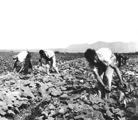
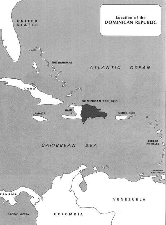
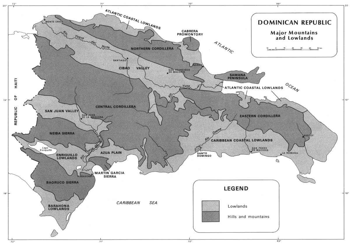
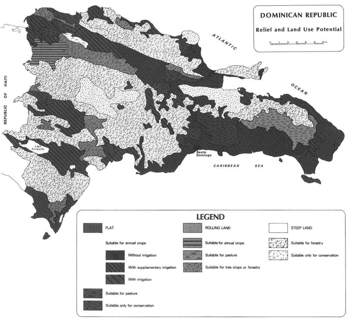
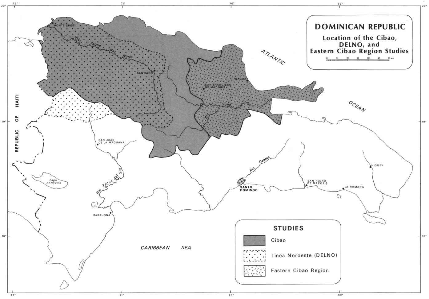
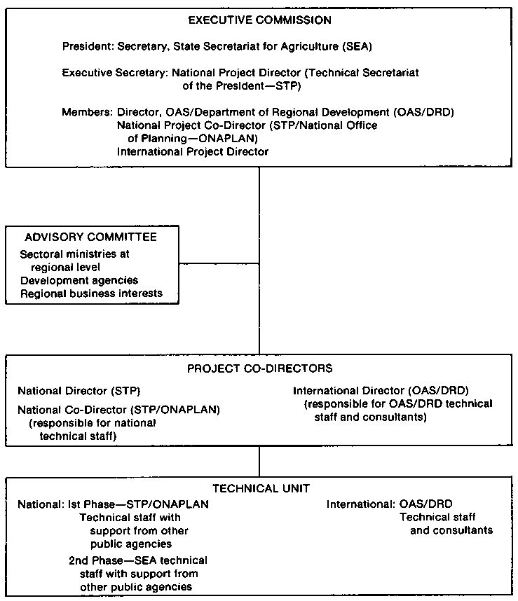
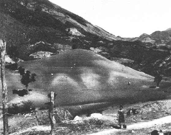
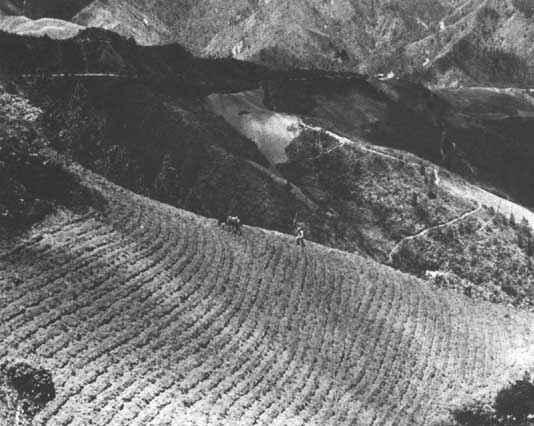
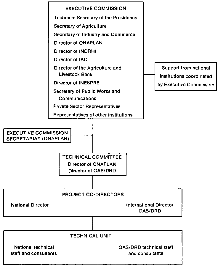
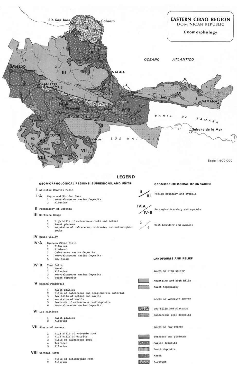
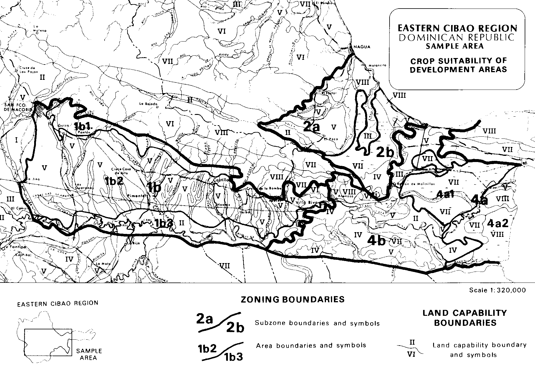
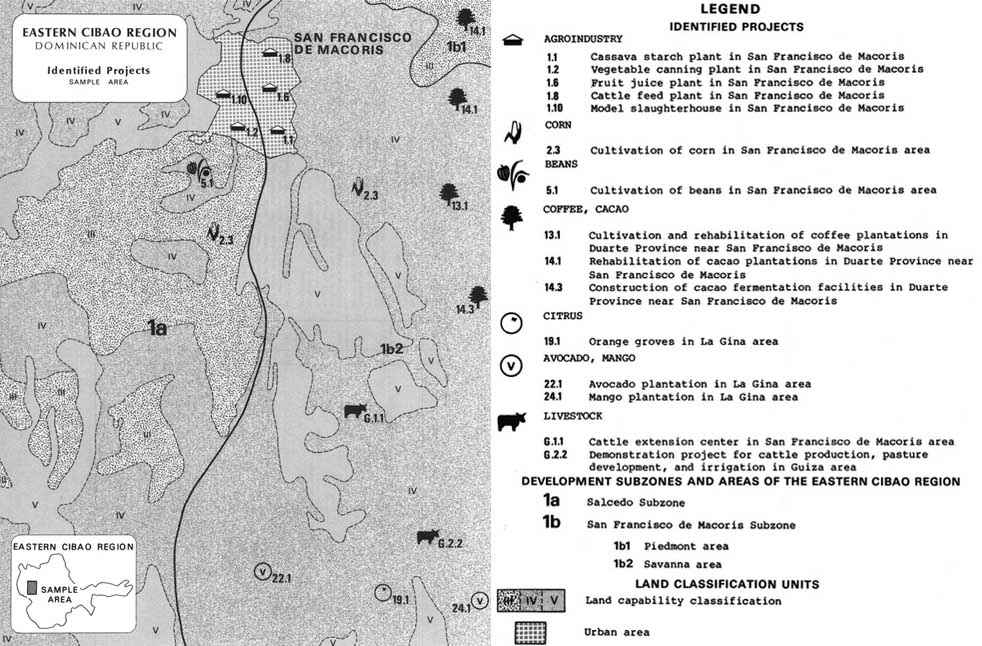
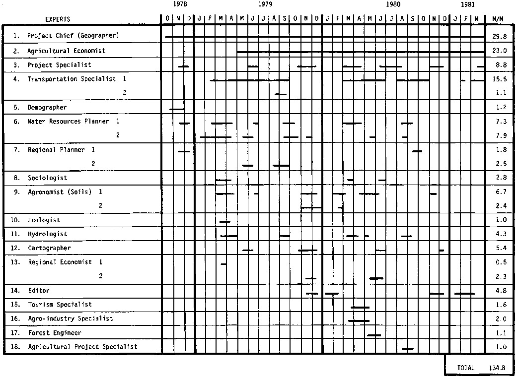