Caribbean Disaster
Mitigation Project
Implemented by the Organization of American States
Unit of Sustainable Development and Environment
for the USAID Office of Foreign Disaster Assistance and the Caribbean Regional Program


Caribbean Disaster
Mitigation Project |
|
Over the past two decades, the Caribbean region has experienced a dramatic upsurge in the level of destruction caused by hurricanes and tropical storms. Although little can be done to change the character or frequency of these events, the damage and loss of life that they cause can be significantly reduced through changes in the location and quality of design and construction, and through appropriate contingency planning for emergency events. Central to reducing the hazard’s impact is an understanding of the force and characteristics of the hazard.
With appropriate information on storm surge and wind hazard risks in the Caribbean region, emergency managers, development planners and meteorologists throughout the region can better prepare for, and respond to, destructive storms. Appropriate and cost-effective vulnerability reduction measures—such as building setbacks, higher building standards and construction of protective structures—can be better identified and implemented using accurate information on hurricane hazard risks.
To this end, the USAID/OAS Caribbean Disaster Mitigation Project (CDMP) has supported the development of TAOS/L, a storm hazard model for use in the Caribbean that can be used to assess the impact of storm surge and wave action on coastal areas throughout the region.
Hurricanes occur annually in the Caribbean. Although hurricanes are categorized according to wind speed, damaging winds are only one of the hazards that accompany hurricanes. Coastal storm surges, heavy rains and damaging waves can each inflict damages during a storm, affecting different locations or combining to significantly increase damages in a highly vulnerable site.
Storm surge is the increase in water levels caused by a tropical storm. Many factors combine to raise water levels during a storm (see table and graphic below). Local near-shore bathymetry, the presence of breakwaters and coastline formation determines local variations in the effects of storm surges. Depending upon a site’s location relative to the storm track, maximum storm surge can precede, coincide with or follow the arrival of the maximum winds generated by the storm.
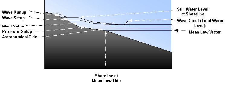
| Surge Component | Definition |
| Storm Surge | The increase in water levels resulting from the passage of a storm. Usually understood to include pressure setup, wind setup, wave setup and astronomical tide. |
| Astronomical tide | The increase due to lunar and solar tides. Astronomical tide effects are typically small in the Caribbean. |
| Pressure setup | The increase in water level due to the lower atmospheric pressure in the interior of a storm. |
| Wind setup | The increase in water level due to the force of the wind on the water. The wind causes currents in the surface layers of the water. This is a factor in shallow areas, where water levels will rise when the water pushed by the winds cannot flow out of the area as quickly as it arrives. |
| Wave setup | The increase in still water levels resulting from mass transport by breaking waves. |
| Wave runup | The area where the inertia of breaking waves carries water up a beach. |
| Still water level at shoreline | The highest water level at a point on the shoreline, if wave action is smoothed out. |
Hurricanes are cyclonic tropical storms. Hurricane strength is typically categorized by the maximum sustained wind speeds within the storm, beginning with speeds of 74 miles per hour. The table below shows the Saffir-Simpson hurricane categories, with the associated wind speeds.
| Sustained Winds | |||
| Category | Miles/hour | Km/hour | Damage Level |
| 1 | 74–95 | 119–153 | Low |
| 2 | 96–110 | 154–177 | Moderate |
| 3 | 111–130 | 179–209 | Extensive |
| 4 | 131–155 | 211–249 | Extreme |
| 5 | > 155 | > 249 | Catastrophic |
Damage from hurricane winds increases exponentially with each increase in storm category—wind power increases with the square of the wind speed. [OAS 1990, p. 12-7.] Flying debris can significantly increase the destructive power of winds, damaging or destroying structures that could have withstood the wind forces alone.
Waves are a constant force, which reshape coastal areas. They wear away rocky shorelines, move sand—eroding or building beach areas—and damage structures in their paths. Hurricane winds can create abnormally high waves, both along the path of the storm and at great distances from it. When combined with increased water levels from storm related surges, waves produced during a hurricane can reach areas typically shielded from the direct effects of waves, destroying buildings and dramatically altering the existing shoreline.
The effect that a wave can have on a stretch of coastline is determined not only by the strength of the wave itself, but also by the slope of the bottom offshore, presence of coral reefs or other breakwaters and the shape of the coastline. These factors can dissipate wave energy before it reaches the shore or concentrate it, significantly increasing local wave effects.
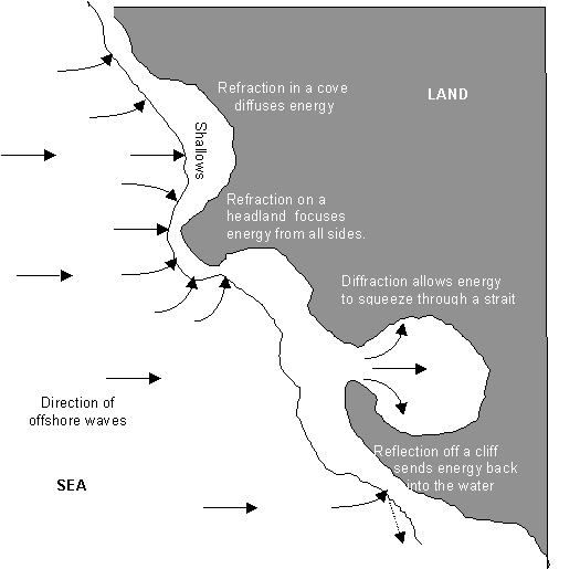
| Refraction | As the edge of a wave passes into shallower water, it slows. The portion of the wave that is still in deeper water passes ahead until it, too, reaches the shallows. In effect, the wave front turns towards the shallower area. |
| Diffraction | As the wave passes an obstruction, the energy of the wave spreads into the undisturbed water behind the obstruction. |
| Reflection | As a wave meets an obstruction, it reflects back into the water. |
Source: OAS 1996.
TAOS/L, a Caribbean version of the TAOS model, was developed by Charles Watson for the Caribbean Disaster Mitigation Project. TAOS is a computer-based numerical model that produces estimates of maximum sustained winds at the surface, and still water surge height and wave height at the coastline, for any coastal area in the Caribbean basin. Model runs can be made for any historical storm, for probable maximum events associated with different return periods, or using real-time tropical storm forecasts from the US National Hurricane Center (NHC).
Many factors make TAOS/L well suited for storm hazard modeling in the Caribbean, especially in agencies and organizations that can make good use of hazard information but have limited resources for developing the necessary information. Advantages of the TAOS model include:
Individual storm. A straightforward application of the TAOS/L model is to estimate the effects of an individual storm on an island or a length of coastline. TAOS/L has the capability to model the effects of historical storms (using a built-in database of storms from the US National Hurricane Center), hypothetical storms (created by the user) or currently active storms (using information from NHC advisories and forecasts). Results of individual storm runs can be displayed as:
Individual storm model runs are useful to understand the effects of historical storms or active storms, using the current forecast track. Individual storm runs can also be used to generate realistic scenarios for emergency management exercises. A storm’s track is a significant determinant of a hurricane’s storm surge and wind effects on a specific area. Since storm tracks are nearly impossible to predict in advance of a storm, individual storm runs are insufficient for long-term planning purposes, whether for development control or for emergency management.
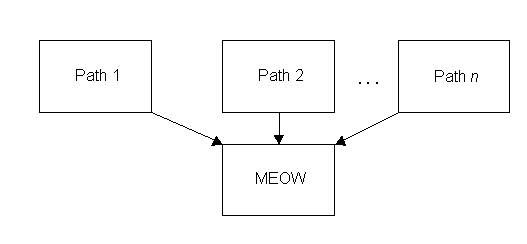
Maximum Envelopes of Water/Wind: A maximum envelope of water/wind (MEOW) depicts the maximum water level (or wind speed) produced by a storm of a chosen intensity, forward speed and track. MEOWs are produced by running the model for multiple storm tracks, spaced a fixed distance apart, for a selected intensity, speed and direction. The results of the individual runs are then combined, into a single map showing, for each point on the map, the maximum value generated across all the individual model runs.
An atlas of maps showing MEOWs of various combinations of storm direction, forward speed and intensity can be developed in advance of a storm event. During an actual event, the appropriate MEOW map (created with the intensity, direction and forward speed of the approaching storm) can be consulted for realistic estimates of the maximum expected wind speeds or storm surge for the active storm. This information can be invaluable in identifying areas most at risk to flooding and determining viable evacuation routes. Since the MEOW was developed from multiple similar storm tracks, no storm will cause all of the effects shown on the map. The MEOW shows the upper bounds that can be expected for a storm with a given set of characteristics, regardless of its landfall location.
Return Periods/confidence levels: Two components are necessary to understand the risk associated with a hazardous event—the magnitude of the event and the likelihood of its occurrence. MEOWs depict the effects produced by a storm of a certain magnitude, but provide no information on the likelihood of the selected event. Using the historical record of storms in the Caribbean and the TAOS model, the CDMP has developed an approach to estimating the maximum storm surge or wind speed for a location for various time frames (e.g. 10-year or 25-year events).
In this approach, TAOS is run for all storms in the database and effects on the site of interest recorded. Annual maximum (surge or wind speed) values are then fitted to a statistical distribution curve. From the resulting curve, it is possible to estimate surges or wind speeds for any return period. Specific steps involved in this statistical analysis (from Johnson, 1997) are as follows:
When compared to other commonly used approaches to estimating storm and storm effect return times, this approach presents a number of advantages. In this approach, the effects of all storms in the historic record are accounted for and the effects recorded reflect those experienced at the site of interest. For instance, if a category 4 storm passing offshore of a point produces category 2 winds, it is recorded as a category 2 event for statistical analysis for that site. This enables the compilation of a complete and realistic database of storm effects for use in the statistical analysis of return times of those effects. Through the statistical distribution curve, it is also possible to estimate confidence levels for any return time estimate.
In using the historical record to estimate future storm effects, it is necessary to make a number of assumptions:
Sensitivity analyses performed as part of the Montego Bay storm hazard assessment found these assumptions to be of little concern. [Johnson, 1997]
The surge height estimates derived from the fitted distribution curve represent the maximum likelihood estimate (MLE) of surge for the corresponding return period. This ‘most likely estimate’ represents an average—although TAOS produces quite accurate results, there is an equal chance that the actual storm surge value will be above or below the MLE value. For critical, high-profile or high-value investments, use of a higher confidence level is warranted to minimize the chance that the storm surge height estimate used in location or design decisions is not exceeded during the design life of the structure. Use of a 90 percent confidence level when estimating surge heights from the distribution curve will result in a higher estimated surge value than the one associated with the MLE, but that estimated surge height will have only a 10 percent probability of being exceeded during selected the return period.
Following a decision of the 17th meeting of the World Meteorological Organization’s Region IV in Guadeloupe in April 1995, the US National Oceanographic and Atmospheric Administration (NOAA) undertook a comparison of TAOS, SLOSH and a French storm surge model. NOAA concluded that all three produce "reasonable" forecasts that are generally consistent with observations from actual storms. For further validation of model outputs, TAOS model has been run on over 25 significant, historical storms from around the world. Comparing over 500 peak surge observations with TAOS model estimates for the same location and time, the model generates results within .3 meters (less than 1 foot) 80 percent of the time, and less than .6 meters (about 2 feet) 90 percent of the time. [Watson 1995]
The Caribbean Institute for Meteorology and Hydrology (CIMH) is the institutional home for the TAOS/L model in the region. The first version of TAOS/L was installed at CIMH in December 1994 and tested during 1995. Based on CIMH’s experience with the model, its capabilities and ease of use were enhanced. The latest version of TAOS/L was installed in CIMH in December 1997.
The CDMP has provided training and support to CIMH on use and application of the TAOS model. CIMH, in turn, has begun to integrate TAOS into its curriculum. CIMH uses TAOS/L in training meteorological officers throughout the region in the interpretation of tropical storm forecasts. In 1997, CIMH conducted a regional workshop on applications of TAOS/L for meteorologists from its member countries. CIMH has recently begun to use TAOS/L to develop an atlas of storm hazard maps to assist meteorologists and emergency managers with planning for hurricane hazards. The first set of these maps will be produced for Antigua in the fall of 1998.
Within the CDMP, TAOS/L has been used to map storm-related hazards at various locations throughout the Caribbean. A 1995 study of Parham Harbor, Antigua, included modeling of storm surge and inland flood hazards. In 1996, TAOS/L was used to assess coastal surge and inland wind hazards in Belize, and to assess storm surge and wave effects on the west coast of Dominica as part of a Caribbean Development Bank-funded coastal rehabilitation project. In Jamaica, TAOS has been used to model storm surges in Montego Bay and is currently being used to map wind and storm surge hazards in the Kingston metropolitan area.
Return time analysis: Using TAOS/L, it is possible to estimate the storm surge and wind hazard for any tropical storm. For use in long-term planning, however, the storm or set of storms used for modeling must represent a realistic event with some estimate of the likelihood of the event’s occurrence. Two approaches to return time analysis have been used in CDMP coastal storm hazard assessments. In the first group of studies (Antigua, Belize, Dominica and the first two undertaken in Montego Bay), a representative storm was selected by analyzing the historical database of storms using a moving window corresponding to the return time of interest. In later studies (the final Montego Bay study and the Kingston study), the statistical return period approach described above was used.
In the ‘moving window’ approach, historical storm tracks, beginning with 1886, were extracted from the US National Hurricane Center database of historical storms for the target location(s). Each storm in the database was processed to assess its impact on the target location using the TAOS wind model. General statistics were extracted from the wind model results and then used to tabulate a distribution of return times for use in the storm hazard modeling. Statistics used in this analysis include:
For the Montego Bay coastal hazard assessment and the Kingston multi-hazard assessment, the statistical framework described under section 2.1 was used to estimate surge levels for various return periods.
In 1995, CDMP undertook a storm hazard assessment in Antigua, to support a plan for the upgrade of the tourist infrastructure in Parham Harbor. This study included an analysis of historical storm return times, the creation of a series of storm surge maps and the estimation of storm-related wind and wave effects. Five storm surge MEOW maps—one for each Saffir/Simpson storm category—were produced for this assessment. Since practically every storm that has affected Antigua has approached the island heading west, only westerly storm tracks (WNW) were used in the storm surge modeling.
Wind and wave hazards were not directly included in the storm hazard modeling, however, qualitative assessments were made for these hazards. Since Parham harbor is located in a low-lying, unprotected location on the coast, "the area should be affected by the full force of the winds produced by a tropical storm or hurricane." [OAS 1995a] The harbor is relatively well protected "…from waves from all directions except the Northeast… For a WNW storm, direct wind driven waves occur during the time of maximum surge, while swells occur after storm passage." [OAS 1995a]
Because of the wide, shallow offshore shelf to the east of Belize, the low-lying coastal areas of the country are at high risk of destructive storm surges. In 1995, CDMP conducted a return time analysis and storm surge mapping project for the coast of Belize. The return time analysis was undertaken for five locations, with the locations selected to demonstrate the variability of return times along the coast. Because of the geographic location of Belize in the Atlantic Basin, and the geometry of the Gulf of Honduras and Central America, there is a strong north/south gradient to the occurrences of storms. The northern coast of Belize is exposed to more frequent and more intense storms than the southern part. For example, tropical storm events are expected to occur in Punta Gorda on average every 6 years, while in Ambergris Cay they typically occur twice as often, every 3 years. [OAS 1995b]
Ten maps were produced for eastern Belize—one map for maximum winds and one for storm surge for each of the Saffir/Simpson storm categories. These maps were produced by combining the results of storm model runs for various storm tracks within a each category. Wave hazards were not included in the Belize storm hazard assessment.
Dominica is a volcanic island, with steep slopes down to the coast and a narrow underwater shelf. The steep slopes along the coast limit inland storm surge during hurricane events, but also force significant public infrastructure, such as the main island road, into highly vulnerable locations immediately along the coast. A steeply sloping shelf just offshore allows waves to reach the coast with a greater proportion of the wave energy intact. [OAS 1996] During the first half of September 1995, two hurricanes—Luis and Marilyn—moved through the eastern Caribbean, causing significant damage. In Dominica, the coastal defenses were destroyed at a number of locations along the west coast of the island. As part of a project to rebuild the damaged coastal infrastructure, the CDMP undertook in 1996 a storm surge and wave hazard assessment for the west coast of Dominica, to ensure that the rehabilitation designs are sufficient to withstand future storm hazards.
To ensure that the results of Dominica storm hazard assessment were sufficiently precise for engineering design, a highly detailed (100 m grid cell) topographic and bathymetric database was developed for this assessment using admiralty charts and multiple remotely sensed images. Since the dynamic action of waves is responsible for the majority of the damage to coastal protective structures, detailed wave hazard models were used in this assessment. Using the ‘moving window’ approach, representative storms with return times of 5, 10, 25 and 50 years were selected and modeled using TAOS and the detailed wave models.
Increases in water levels due to storm surge and waves were computed at six locations along the coast for each of the representative storms. The storm surge contribution to total storm water levels was similar at each location for each event, while the wave contribution varied significantly due to local bathymetry and coastline shape. Total water levels predicted for 5-year events would have minimal effects on the coastal road, while the 50-year water levels would threaten the coastal road along practically this entire stretch of coast. The threat posed by 10-year and 25-year events varies along the coast, depending upon the predicted wave heights and the location of the coastal road. [OAS 1996]
From 1994 through 1997, CDMP has undertaken three storm hazard assessment activities in Montego Bay. These assessments have been undertaken in coordination with the Jamaica Office of Disaster Preparedness and Emergency Management (ODPEM) and the Jamaica Institute of Engineers (JIE). The purpose of each of the three assessments was the same—to produce valid maps of hurricane storm surge hazards for use in emergency management and land development planning for Montego Bay. The TAOS model was used for all three studies. The primary difference between the studies was in the selection of return period for use in modeling.
In the first Montego Bay storm hazard mapping exercise (1994), the ‘moving window’ approach was used to select a 100-year storm for modeling; the selected storm and resulting surge estimates were deemed overly extreme by reviewers in Jamaica. In response to these concerns, CDMP produced a series of storm hazard maps in 1995, showing storm surge estimates for category 1, 3 and 5 storms on north, west and southwest tracks. No attempt was made in this study to attach return periods to any of these storm events. Little use was made of this map series. In a 1997, the JIE clarified that for surge maps to be useful in their work, the maps must show surge heights associated with return periods calculated on surge height, rather than storm category and direction. From this, CDMP developed the statistical return time analysis described under section 2.1.
1994 study: In this report, the historical database of storms was analyzed for storms affecting Montego Bay, using the ‘moving window’ approach. Based on this analysis, a strong category 2 storm was recommended as the 25-year event, a strong category 3 storm for the 50-year event and a strong category 4 storm for the 100-year event. A strong category 4 storm on a ‘worst case’ track (on a west heading, with landfall near Montego Bay) was used to model the 100-year event. Seven page-sized maps, at a scale of 1:12,500, were produced to show the storm surge model results superimposed upon a topographic map of the Montego Bay area. [OAS 1994 — See note 1]
1995 study: This study differed from the 1994 study in three respects: an revised statistical assessment was presented using an updated wind model, an updated topographic database was used for the storm surge modeling and no design storms (return periods) were used in the mapping section of the study. MEOW maps were produced for category 1, 3 and 5 storms on each of three typical tracks for Montego Bay—north, west and southwest—for a total of nine category/storm combinations. [OAS 1995 — See note 1]
1997 statistical study: The goal of the final Montego Bay study was to map storm surge heights (and the corresponding flooded areas) for various return intervals in Montego Bay, regardless of the magnitude of the storm that caused the surge. All previous CDMP storm hazard-mapping activities mapped the effects of individual storms or a group of closely related storms. Such maps are important tools for emergency management, for the development of response plans to specific, significant events. Because of the difficulty of assigning return periods to specific storm events and the variation in effects caused by an individual storm, however, such maps are not as directly applicable to land development planning. For physical planning, it is the probability of the hazard (e.g. storm surge) occurring, rather than the recurrence interval of the event (e.g. a category 3 storm on a northwest track), that is most important.
In this study, the TAOS model was run for all storms in the NHC historical database, which included 959 storms over the years 1886–1997. Included in the storm surge height estimates were the wave, wind and pressure setups and the astronomical tidal components. For each storm, the estimated surge height was recorded, measured just offshore Doctor’s Cove beach.
For the statistical analysis, annual maximum surge values were used in the rest of the study (instead of individual storm surge heights), to ensure the independence of observations. Multiple statistical distribution curves were fitted to these annual maxima. After careful investigation, the Weibull distribution was selected as the most appropriate distribution, based on goodness of fit to the maximum values and realistic estimates of small probability events (100-year returns and greater).
Using the fitted distribution curve, it is possible to estimate the ‘maximum likelihood estimate’ of storm surge height for any return period. Alternatively, surge height estimates with a higher level of confidence (i.e. a lesser chance that the predicted value will be exceeded during the return period) can be derived by simulating a large number of storm surge estimates, based on the characteristics of the fitted curve and a given return period. The resulting simulated values can be sorted and the surge height with the appropriate confidence level selected. For example, from a sorted list of 1000 surge estimates with a 25-year return period, derived using the characteristics of the fitted curve, the 900th value would represent the 25-year surge estimate with a 90 percent confidence level. [See Johnson 1997]
For the 1997 Montego Bay storm hazard mapping assessment, the 10-, 25-, 50- and 100-year surge heights at Doctor’s Cove beach were estimated for the maximum likelihood estimate and the 90 percent, 95 percent and 99 percent confidence levels.
In 1998, the CDMP began work on the coastal hazard assessment for the Kingston metropolitan area. This storm hazard assessment is based on the same approach that was developed for Montego Bay. In this assessment, the methodology developed for storm surges will also be applied to maximum winds. This assessment will be complete by the end of 1998.
Johnson, Mark, 1997. Caribbean Storm Surge Return Periods: Final Report of a Case Study for Montego Bay. Washington: Caribbean Disaster Mitigation Project report series.
Organization of American States, 1990. Primer on Natural Hazards Management in Integrated Regional Development Planning. Washington DC
Organization of American States, 1994. Montego Bay 100-Year Hurricane Coastal Flooding Hazard Assessment. Caribbean Disaster Mitigation Project report series: Washington.
Organization of American States, 1995a. Storm Hazard Assessment for Parham Harbor, Antigua. Caribbean Disaster Mitigation Project report series: Washington.
Organization of American States, 1995b. Storm Hazard Assessment for Belize. Caribbean Disaster Mitigation Project report series: Washington.
Organization of American States, 1995c. Storm Hazard Assessment for Montego Bay, Jamaica. Caribbean Disaster Mitigation Project report series: Washington.
Organization of American States, 1996. Wave Hazard Assessment for Selected Locations on the West Coast of Dominica. Caribbean Disaster Mitigation Project report series: Washington.
Vermeiren, Jan, and Watson, Charles C. 1994. New Technology for Improved Storm Risk Assessment in the Caribbean. Paper presented at the 1994 Conference of the American Society of Civil Engineers.
Vermeiren, Jan, 1995. Engaging Planners and Investors in the Assessment of Storm Risk in Jamaica. Paper presented at the 1995 Conference of the American Meteorological Society.
Watson, Charles C. Jr. 1995. "The Arbiter of Storms: A High-Resolution, GIS-Based System for Integrated Storm Hazard Modeling" National Weather Digest. Volume 20: Number 2, pp. 2-9.
Watson, Charles C and Vermeiren, Jan C. 1997. "Incorporating Variability in the Disaster Planning Process" in Hurricanes: Climate and Socioeconomic Impacts. Diaz, Henry F. and Pulwarty, Roger S. editors. Springer: Berlin.
| CDMP home page: http://www.oas.org/en/cdmp/ | Project Contacts | Page Last Updated: 20 April 2001 |