 Hazard Mitigation Planning
The Caribbean Disaster Mitigation
Project:
Supporting Sustainable Responses to Natural Hazards
Steven Stichter, Caribbean Disaster Mitigation Project (CDMP)
Unit of Sustainable Development and Environment, Organization of American States
1889 F Street NW, Washington DC 20006
Tel: 202 458 3300, Fax: 202 458 3560
e-mail: [email protected], web: http://www.oas.org/en/cdmp/
Abstract
Nations in the Caribbean are subject to a wide range of natural hazards—hurricanes, landslide, earthquakes, tsunamis and volcanoes. To grow and develop without taking these hazards into account can have grave consequences with the advent of a hazardous event. The Caribbean Disaster Mitigation Project has supported a range of initiatives with the goal of reducing the vulnerability to natural hazards throughout the region. One of these approaches is hazard mitigation planning. Through this planning process, the risk and susceptability associated with an areas hazards are analyzed; this information is then used to develop sustainable and viable responses to mitigate the effects of these hazards. Geographic information systems can play a significant role in mitigation planning, in hazard and vulnerability analysis, as well as in presentation of results and public education. Use of GIS in this planning allows the rapid consideration of numerous hazard scenarios in support of plan and policy development, leading to a region in the future that is less susceptible to the effects of hazards than it is today.
Introduction
Over the past two decades, the Caribbean region has experienced a dramatic upsurge in the level of destruction caused by hurricanes and tropical storms. Events in Dominica, the Dominican Republic, St. Lucia, Jamaica and other Caribbean Nations during this period served to focus attention on the destabilizing effects of these natural hazards. While storms and related flooding and landslides are the most frequently experienced hazards, earthquakes and volcanoes also pose significant risk to the region. Reducing the risk of damage and injury from natural hazards is critical for sustainable development in the Caribbean region. Disasters resulting from natural hazards can set the economy of an island nation back for years. At the same time, external and internal funds spent repeatedly to rebuild after hazard events are unavailable to be invested to support economic development and expansion. (Caribbean Disaster Mitigation Project Document, 1993)
The Caribbean Disaster Mitigation Project (CDMP) is a joint effort of the Organization of American States (OAS) and the US Agency for International Development (USAID). The purpose of the project is to establish sustainable public/private disaster mitigation mechanisms that measurably lessen loss of life, reduce potential damage, and shorten the disaster recovery period from disasters due to natural hazards. The project is implemented through a series of pilot projects in selected countries, and through regional training and information dissemination activities. Activities promoted by the CDMP to effect a long-term reduction in susceptibility to natural hazards in the Caribbean, include housing rehabilitation and retrofit, community preparedness, hazard mitigation planning and work with the insurance sector to promote incentives for hazard mitigation. This paper will focus on hazard mitigation planning and the use of geographic information systems to support that planning process.
Hazard Mitigation Planning
Hazard mitigation planning is a comprehensive approach to natural hazard risk reduction. This approach enables a broad understanding of the effects of prevalent hazards and the setting of priorities for responding to these hazards. Traditionally, post-disaster redevelopment plans and guidelines have only been prepared after an event, when needs are greatest and pressure for action is intense. Development of a comprehensive mitigation plan prior to the arrival of a disaster provides many benefits. The costs of hazard mitigation can often be greatly reduced when introduced in the design and construction phase of new development. In government operations, many opportunities for hazard risk reduction are available, from pre- and post-disaster preparedness through everyday operations of various departments, such as public works, planning and building inspection. Existence of a mitigation plan prior to the occurrence of a disaster increases the chances that rebuilding activities after the event will reduce future vulnerability, rather than reproducing the pre-disaster, often highly vulnerable, state.
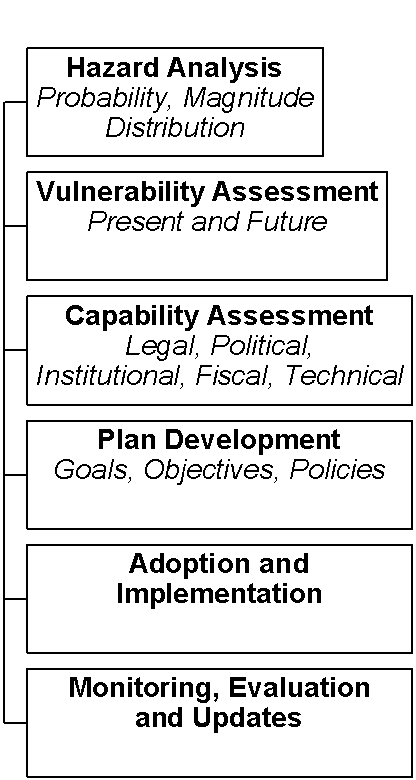
The hazard mitigation planning process begins with the commitment to reducing hazard vulnerability and support for mitigation planning by the government, which often requires education and orientation of decision-makers. Once a commitment to hazard mitigation has been made, the next step is to undertake background studies, which are necessary to understand hazard characteristics and options for response. Such studies include assessments of the probability and severity of hazard events, determination of current and future vulnerability, and appraisal of current capability to implement mitigation measures. Policies that describe steps toward a lower-risk future can be developed based on the mitigation goals, information about existing hazards, hazard vulnerability and response capabilities. The stages of the hazard mitigation planning are illustrated in Figure 1 and described below.
Hazard analysis begins with an enumeration of the hazards present in the area of study. For each of the hazards listed, the risk of experiencing that hazard must be estimated. Using historical records or statistical estimates, risk can be assessed by looking at the probability, frequency, strength and distribution of occurrence of the hazard and its effects. Secondary effects, such as landslides caused by heavy rains and flooding, should also be considered here. Once this information has been collected for all hazards, the specific hazards to be addressed in the mitigation plan can be selected.
In a vulnerability assessment, the results of the hazard analysis are applied to development, population, economic or natural resource information to determine the potential effects of a given hazard. Vulnerability analyses are limited only by the information that is available and require a sufficient understanding of the link between the magnitude of the hazard, such as high winds and flood height, and its effect on the resource at risk. For instance, building damage and failure rates increase as wind speeds increase, but at differing rates depending upon building types. With information on the distribution of building types in an area and the wind damage curves for those building types, it is possible to estimate damages inflicted by storms of a given wind speed. Loss of critical infrastructure, such as hospitals, electrical plants and key industrial facilities, can significantly affect recovery from a disaster. Special attention should be paid in this analysis to the vulnerability of such infrastructure.
As an area grows and develops, its vulnerability to hazards changes. New development in low coastal areas or floodplains could significantly increase damages in future events, while retrofitting and building to higher standards can decrease future vulnerability. Where possible, estimates of both present and future vulnerability should be made. Depending upon the information available, results of a vulnerability analysis can be calculated in many ways, including the estimated value of damages, number of jobs lost and number of people left without homes. These can be presented in tabular form or as maps of areas affected by a given hazard.
A capability assessment reviews the ability of a government, individual or company to address hazards. Such an assessment should review technical ability, financial resources, legal and institutional frameworks and political will. A capability assessment can reveal gaps in existing response and control capabilities as well as take credit for currently functioning mitigation activities. This assessment can help identify policy and structural changes that must be made to institutionalize mitigation. Some mitigation options may be eliminated from consideration due to barriers to implementation identified during the capability assessment.
Once background studies are complete, the plan development can begin. In the planning process, hazard and vulnerability studies are used to identify the hazards of concern and the areas at risk to those hazards. The core of the plan, however, is composed of the mitigation goals, objectives and implementation policies. Goal statements define the vision for achieving a less hazard-prone future. Objectives are derived from goals, but are more concrete; objectives should be achievable in the foreseeable future. Policies describe specific steps to be taken in completing the plan’s objectives. The implementation policies are the plan’s "marching orders" for reducing hazard risks. The goals, objectives and implementation policies must be developed in consultation with all agencies and parties affected and with those expected to implement the plan.
To be effective, a plan should be adopted by the appropriate authorities and implemented as described in the objectives and policies. A well-constructed plan that has no authority or is never referenced has little use. When pursuing plan adoption and implementation, information collected in the background studies, particularly maps and descriptions of vulnerability and the potential magnitude of losses can provide powerful supporting arguments. Adoption can take many forms depending upon the existing legal framework and geographic focus of the plan.
A hazard mitigation plan is never complete—at all times, however, an adopted mitigation plan should be in place to guide actions during and following any disaster that may occur. As new growth and development occurs, the context for mitigation changes. Growth in previously undeveloped areas may be vulnerable to hazards, or increase vulnerability elsewhere (e.g. downstream.) New information may become available about hazard recurrence or the link between hazards and damages. The hazard mitigation plan should be sufficiently flexible to recognize and address these changes. Monitoring and evaluation of the mitigation plan is critical to ensure that the recommendations made were appropriate and have the intended effects. To chart the progress of implementation, indicators can be established when developing mitigation policies. Updates to plans should be undertaken as needed.
Geographic Information Systems in Hazard Mitigation Planning
Hazards, such as hurricanes and floods, are naturally occurring phenomena. These ‘hazards’ are not typically called ‘disasters’ until they threaten human life or destroy human development. Consequently, geography—where hazards occur and where settlements and development exist—is a critical factor in assessing hazards and planning to minimize resulting disasters. Geographic information systems (GIS), with their ability to combine information from a variety of sources such as maps, computer models and remotely sensed imagery, can be useful tools in understanding the patterns and potential effects of hazards. Throughout the planning process, GIS is useful as an integrating tool and as a warehouse for information collected and produced during the planning process. GIS is a versatile tool, allowing it to play a supportive role during many stages of mitigation planning.
During the background studies and assessments, a GIS can serve as a base for hazard inventories. Over the past decade, a large number of new sources of information have been developed which are easily integrated into a GIS. These include both airborne and satellite-based imagers, global positioning systems and commercially available base data. In hazard assessment, remotely sensed imagery has been used during plan development to inventory current resources and development and after an event to estimate the extent of damages. Newer hazard assessment models exist which are built within or linked to a geographic information system.
In vulnerability analysis, the GIS’ ability to integrate and overlay disparate data sets can be a powerful tool. For instance, properties at risk to landslides can be identified by using a GIS layer of landslide susceptibility zones to select parcels from a cadastral layer that fall within those zones. The use of a GIS for vulnerability analysis can greatly expand the number and range of impact scenarios considered. For instance, the analysis of parcels at risk to landslides can be repeated for multiple future development scenarios by changing the cadastral information used. Alternatively, current development at risk to different categories or magnitudes of landslides can be estimated by adjusting the landslide hazard information used in the analysis. At the completion of the background studies, the different data types produced can be combined in a multi-hazard analysis using the ability within a GIS to reclassify hazard information into susceptibility zones.
GIS maps of hazard information are useful in educating the public about hazards and convincing decision-makers of the need for hazard risk reduction. With hazard information available in GIS form, the vulnerability of new development can easily be assessed at the beginning of the development cycle. Ready availability of hazard information from the previous plan in GIS form also eases update of the plan, as only those pieces of information that have changed must be updated; analyses can then be repeated as before with the updated information.
Within a GIS, it is possible to display on the same map information that was developed or collected at a wide variety of scales. Satellite imagery, model outputs and building footprints could all be combined on either a regional or a site-specific map, but such a display could lead to inaccurate conclusions. When combining information, either for analysis or display, it is important to consider the appropriateness source scale of the information used.
Kingston Multi-hazard Assessment
The CDMP has supported numerous natural hazard assessments in participating countries. Storm surge hazard assessments have been carried out for portions of Antigua, Dominica, Belize and Jamaica. A map of wind hazards has been developed for the island of Hispaniola and a river flood model is under development for Belize. The most comprehensive set of assessments, however, is presently underway in Jamaica for the Kingston metropolitan area.
The island of Jamaica is subject to many natural hazards, including tropical storms, landslides and earthquakes. Hurricanes Allen (1980) and Gilbert (1988) and tropical storm Gordon (1994) passed over or close to the island, causing significant wind and flood damage. The geology, topography and land uses of Jamaica make it susceptible to recurrent landslides, due both to natural causes and human development, such as vegetation clearing and road cuts. Jamaica, Haiti, the Dominican Republic and Puerto Rico sit atop the same line of faults, exposing the islands to earthquakes and related hazards.
The CDMP is supporting assessments of seismic, landslide and coastal storm hazards in the Kingston metropolitan area. Maps of historical occurrence of these hazards are under development, as are maps of areas susceptible to hurricane storm surge, wind effects, landslides and seismic-related ground shaking and liquefaction. Upon completion, the historical information, hazard assessments and susceptibility zones will be integrated into a common GIS database. This database will then be used to produce multi-hazard maps. The database will be distributed to appropriate governmental agencies in Jamaica. Results of the Kingston multi-hazard assessment (KMA) will serve as an example of a comprehensive, multi-hazard assessment, for use in hazard mitigation planning. This paper will discuss the components of the KMA, application of GIS to these assessments and the link between these assessments and a hazard mitigation plan for Kingston.
Methods
Seismic Hazard Assessment
The seismic hazard assessment for the Kingston metropolitan area is being conducted by the Earthquake Unit of the University of the West Indies (UWI). Components of this assessment that have been completed are an earthquake catalog, a preliminary seismic attenuation model and a geologic map series, which includes a digital terrain model and maps of surface geology, depth to bedrock and groundwater. A bibliography of literature related to attenuation models, seismo-tectonic models, stress maps and computer models for calculation of ground motion will be produced to support development of a final probabilistic ground motion model for Kingston. With this model, it will be possible to estimate ground shaking and liquefaction resulting from seismic events. Results from this model will be translated into seismic hazard susceptibility zones for the multi-hazard assessment.
Landslide Hazard Assessment
The UWI Geology Department is undertaking the landslide hazard assessment for the KMA. As a basis for the landslide susceptibility map, maps of geology, slope categories, hydrology and a historical landslide inventory will be produced. Field work and aerial photograph interpretation for the landslide hazard assessment has been completed. These surface and geologic inventories will be combined with topography information within a GIS-based landslide hazard model to produce maps of landslide susceptibility.
 As a companion to the landslide susceptibility maps, a landslide risk
reduction manual is under development to guide the development of policies and standards
for reducing landslide risks. This manual will provide planners, developers and engineers
with guidelines for use of the landslide susceptibility information; recommendations
reducing and controlling landslides through cut slope design, road and drainage control,
design of retaining structures and hillside land-use practices; and guidelines for
site-specific studies to be carried out for project assessments in hazard-prone areas.
As a companion to the landslide susceptibility maps, a landslide risk
reduction manual is under development to guide the development of policies and standards
for reducing landslide risks. This manual will provide planners, developers and engineers
with guidelines for use of the landslide susceptibility information; recommendations
reducing and controlling landslides through cut slope design, road and drainage control,
design of retaining structures and hillside land-use practices; and guidelines for
site-specific studies to be carried out for project assessments in hazard-prone areas.
Coastal Storm Surge and Wind Hazard Assessment
The Natural Resources Conservation Authority of Jamaica, with the assistance of CDMP, will conduct the coastal storm surge and wind hazard assessment using the TAOS/L storm hazard model. The TAOS/L model, developed by Charles Watson for the CDMP, is a computer-based, numerical model that produces estimates of maximum sustained wind vectors at the surface, and still water surge height and wave height at the coastline, for any coastal area in the Caribbean basin. The model relies on a generic data base structure, and uses USGS digital data for deep ocean bathymetry, Digital Chart of the World data for land boundaries and rough topography, satellite imagery for near shore bathymetry and land cover, and the National Hurricane Center data base for storm data. Model runs can be made for any historical storm, for probable maximum events associated with different return periods, or using real time tropical storm forecasts from the US National Hurricane Center (NHC). TAOS/L is integrated into a GIS, which eases entry of model data and presentation of model results.
Use of a numerical model is critical for estimating storm surge, even in areas where good information exists on historical storms and storm effects. The effects of a hurricane on a given location reflect many variables, such as the storm track, speed and intensity and the tidal cycle. It is extremely unlikely that a future storm will match the characteristics of any previous storm, but were that to occur, changes in bathymetry, coastal development and clearing of hillside vegetation can all significantly change the effects of such a storm.
Through TAOS/L, maps of storm surge inundation limits in the Kingston metropolitan area can be produced for different hurricane storm scenarios. With each storm run, TAOS/L also produces a map of maximum sustained winds. TAOS/L wind and storm surge hazard model results will be incorporated directly into the project’s GIS database.
Multi-hazard Mapping
The final stage of the KMA is the production of a multi-hazard map series, which will combine all hazard assessments carried out under this project. A necessary first step towards the production of this map series is the creation of a common database of hazard information in a GIS. In addition to the hazard information produced for the assessment, geographic features such as shorelines, rivers and roads will be included for reference and mapping. The database will be referenced to the Jamaica 1:50,000 topographic map series. Table 1 lists the components of this database. The final GIS database and map series will be made widely available within the Government of Jamaica and to others involved in land development in the Kingston metropolitan area.
Links to Mitigation Planning
The CDMP Kingston Multi-hazard Assessment will be complete with the production of the multi-hazard maps and distribution of the GIS database. The KMA is being supported as an example of development and integration of hazard assessments to plan hazard vulnerability reduction activities. The information produced in the KMA is valuable information in the development of a hazard mitigation plan for the Kingston metropolitan area. All information from this project will be available to any agency in Jamaica that has interest or involvement in hazard mitigation. These agencies will be encouraged to initiate a mitigation planning process.
Discussion
Due to its versatility and ability to integrate diverse types of information, a GIS can be a valuable tool in development, monitoring and update of a hazard mitigation plan. Despite these benefits, use of GIS in mitigation planning must be approached with caution. Lack of appropriate expertise, access to necessary hardware or information in electronic form can significantly delay a project. In the KMA, for instance, access to appropriate base maps and unwillingness by agencies to share information significantly delayed one project component. Development of open, reciprocal arrangements for sharing of data, little-used hardware and expertise between agencies can considerably reduce the costs of GIS implementation and operation for all. One of the benefits of GIS, the ability to combine data from maps of varying scales, must also be applied carefully. Initial hazard assessments are often produced at a much coarser scale than available information on development, which can be as fine as engineering-scale drawings. Care must be taken in vulnerability assessments not to overstate the precision of such estimates.
Maps of hazard occurrence and susceptibility, created in a GIS or produced manually, are not an end unto themselves. They are important tools that can guide safer development planning. Using this information, a community, city or region must determine which areas are appropriate for development and the standards that are required to ensure the safety of that development. The mitigation planning process outlined in this paper is a straightforward approach for analyzing an area’s hazards and determining viable approaches to hazard risk reduction. By developing a plan for reducing hazard risks before the advent of a disaster, a community can take advantage of daily opportunities to reduce vulnerability, and be better positioned to rebuild appropriately in the hectic period after a disaster.
Further information on activities of the Caribbean Disaster Mitigation Project is available on the CDMP web site at http://www.oas.org/en/cdmp
Acknowledgements
The Caribbean Disaster Mitigation Project is funded by the US Agency for International Development through the Caribbean Regional Program in Kingston, Jamaica. The Organization of American States is the executing agency for the CDMP. Chuck Watson, principal of Watson Technical Consulting, has provided critical support to CDMP hazard assessment work throughout the project. The Jamaica Natural Resources Conservation Authority plays a pivotal role in the KMA, as the coordinating governmental agency for the project. David Brower, of the University of North Carolina at Chapel Hill, developed the mitigation planning process described in this paper.
References
Brower, David. Planning to Mitigate the Impacts of Natural Hazards in the Caribbean. OAS/USAID Caribbean Disaster Mitigation Project, Washington DC. 1997.
Organization of American States. Primer on Natural Hazard Management in Integrated Regional Development Planning. Washington DC. 1991.
Stubbs, Norris. Estimation of Building Damage as a Result of Hurricanes in the Caribbean (A Primer). OAS/USAID Caribbean Disaster Mitigation Project, Washington DC. June 1996.
USAID/OAS Caribbean Disaster Mitigation Project, Project Document. Washington DC, 1993.