Caribbean Disaster
Mitigation Project
Implemented by the Organization of American States
Unit of Sustainable Development and Environment
for the USAID Office of Foreign Disaster Assistance and the Caribbean Regional Program


Caribbean Disaster
Mitigation Project |
|
The Liguanea Plain is a broad, low-lying alluvial plain which underlies much of the Kingston Metropolitan Area (KMA). Young, unconsolidated alluvial deposits, such as those comprising the Liguanea Plain, can selectively amplify strong ground shaking during earthquakes, with the period and degree of amplification proportional to the thickness of the alluvium. As was discovered during the first phase of the Kingston Seismic Hazard Assessment, little information is available concerning the thickness of the alluvium beyond a few deep borings (>200 m) that did not penetrate basement rock. An accurate assesment of the seismic hazard in the KMA is dependent upon better defining the thickness of the alluvium, but resources for gathering additional data are limited.
Several potential research strategies that could determine the depth to bedrock in the KMA were investigated during Phase One. One approach is to drill additional deep wells, thereby improving existing contour maps depicting the minimum thickness of the sands and gravels (Figure A2.1). Deep wells are expensive to drill, and provide only site-specific information. A more cost-effective approach would be to use geophysical exploration techniques, such as seismic reflection or gravity profiling, which can provide data from a greater geographic area in less time and at a much lower cost than drilling. Unfortunately, paved roads, high noise levels, and urban development pose obstacles to many geophysical exploration techniques, specifically seismic reflection/refraction or electrical resistivity methods. Gravity measurements, however, are relatively unaffected by urban development, and only minimally impact the surrounding environment (Kick, 1985).
The National Oceanic and Atmospheric Administration (NOAA), National Ocean Survey (NOS) was scheduled to install a sea level/climate monitoring network station in Port Royal during the first part of June 1998 as part of a separate OAS project. The availability of both Global Positioning System (GPS) and gravity experts through the NOS project provided an ideal set of circumstances for conducting a microgravity survey in Kingston at the same time.
The gravity survey in Kingston consisted of two intersecting, 10-km transects (Figure A3.1), each comprised of 25 stations spaced at approximately 400-m intervals. The east-west profile ran from Papine to Six Miles, along Hope Road, through Kings House grounds and surrounding areas, and along Dunrobin Avenue and Washington Boulevard. The north-south profile ran from Constant Spring to Ocean Boulevard at Kingston Harbor, following Constant Spring Road, Halfway Tree Road, and Orange Street. Attempts were made to survey four pre-existing gravity or well data stations (CSPR, CAMP, PIER H, and PIER 3), bringing the total number of survey points to 54.
Gravity, elevation, and station-location observations were collected during the period of June 9-11, 1998 by Robert Moose, Miranda Chin, and Doug Martin of the NOS, with the assistance of the Jamaica Survey Department, the Hazard Assessment project members and others listed in the Acknowledgements. Station locations, as determined by GPS measurements are listed in Table A3.1. Station locations were surveyed to an accuracy of 5 cm. GPS measurements were tied to the GPS reference station in Port Royal and the International Terrestrial Reference Frame 1996 coordinate system. Gravity measurements were made using two LaCoste-Romberg gravimeters (D17 and G809) in parallel. The use of two instruments guarded against tares and misreadings of the meters, and allowed for an overall precision of less than 15 microgals per observation. Because temperatures during the survey period ranged from 95o - 99o F, the gravimeters were transported in air-conditioned vehicles to minimize thermal effects. To minimize accelerations caused by the rough roads in Kingston, the gravimeters rode in the passenger seat of the field vehicles.
None of the pre-existing gravity control stations in the Kingston area were recovered. Gravity measurements were made at the approximate location of the two closest sites of former control stations (PIER H and PIER 3). These two stations provided the approximate datum (IGSN71) value for the traverses. This datum serves as essentially a single constraint [for determining the absolute gravity] observed at the southern end of the traverse. Larger uncertainties in adjusted gravity values (see Results) occur at the extremities of the other transects.
Station data from the Kingston survey appear in Table A3.1. Following the survey, the NOS adjusted the gravity data to account for instrument drift, latitude, gravitational and solid earth tides, and the local terrain. A correction for the solid earth tide of 16% of the gravitational tide was also applied. Reduced observations were adjusted by the method of least squares using the method of observational equations with weighted constraints. The standard deviation for the data set is provided in Table A3.1, and as mentioned previously, the greatest sigma values occurred furthest from the control station.
Both Free Air and Bouguer corrections were applied to the gravity data, with the anomalies computed according to the formulas prescribed by the Defense Mapping Agency (1994). Three densities were used for the Bouguer correction, a standard value of 2.67 g cm-3 and two values that bracket observed density of the Liguanea Plain alluvium (1.75 and 2.00 g cm-3 , Jentech Consultants Ltd., personal communication, 1998). Gravity values computed with the most widely used reduction density (2.67 g cm-3) and 2.0 g cm-3, considered to be more representative of the average density of saturated, unconsolidated alluvium, appear in Table A3.1. While there are appreciable differences in the values computed with each density, the overall trend remains the same. Since the entire survey was conducted within the confines of the Liguanea Plain, the values associated with the lower reduction density were used for the remainder of the study.
In order to account for smaller variations in topography that the Bouguer correction does not remedy, a terrain correction is commonly applied to the data. In this survey, terrain corrections were computed using a digital, three-second terrain database compiled by the NOS, integrated out to 0.5-degree using a Fast Fourier Transform. The terrain correction was added to the Bouguer anomaly, and the corrected values, used in the subsequent modeling, appear in the final column of Table A3.1.
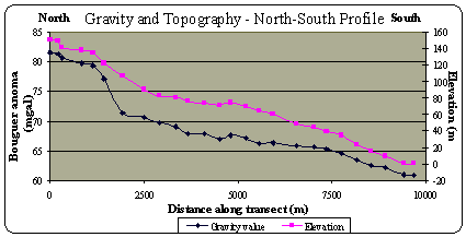
The Bouguer and terrain corrections applied in the previous section are intended to help minimize the correlation of gravity with topography, allowing the correlation of gravity trends with variations in subsurface geology. The observed elevation and adjusted gravity values for both the north-south and east-west are shown in Figures A3.2 and A3.3. There is a rapid decrease in the observed gravity between the 2000 and 2500 m-marks along the north-south transect, and a sharp drop near the -4000 m-mark along the east-west transect. Despite the Bouguer and terrain corrections, there still appears to be a strong correlation between the observation gravity and the topography. This trend would be expected if the subsurface geologic structure controlled the surface topography. In modeling the observed gravity from the Kingston survey, we needed to determine if this type of subsurface control exists.

Free Air and Bouguer gravity data for eastern Jamaica are summarized in Figure A3.4 (after Andrew, 1969 and Wadge et al, 1983b). While few data points exist in the Kingston Metropolitan area, the data collected during the 1998 survey are consistent with the regional values and trends for the area - a relatively gradual southern gradient (40 mgal/10 km) coincident with the location of the Liguanea Plain.
Both the north-south and east-west survey routes were run near known deep well locations. Information from the well logs (listed in Appendix 2) were used to help calibrate the Survey results and provide minimum thickness estimates for the Liguanea Alluvium. Seven wells that penetrate limestone (bedrock) beneath the Liguanea Plain were identified from records. Only three well locations were actually recovered at the time of the Survey for gravity measurements. Data for these three wells are listed in Table A3.2 and will be used later for the depth of overburden calculation.
Well |
Lithology |
Depth to Bedrock |
Gravity (mgal) |
| Campion College | Fine to medium gravels |
182.8 |
76 |
| Kings House | Fine to coarse sands, some clay and silt |
131.2 |
72.5 |
| Constant Spring | Fine to medium sands, coarse gravels |
62.4 |
81.3 |

Crustal models constructed using gravity data are dependent upon reasonable estimates of rock densities, with values determined from rock or sediment samples taken directly from the study area or generalized density ranges gleaned from the scientific literature. Values for lithologies in the Kingston Metropolitan area are listed in Table A3.3. Previous gravity studies conducted in Jamaica include rock density estimates for various units (Wadge et al., 1983a,b). Values for the alluvium and carbonates are based on observational data. Data for the deeper units are taken from Wadge et al. (1983b) and Burger (1992).
Unit |
Published densities |
Density used in models (g cm-3) |
| Alluvium | 1.7-2.31 |
2.0 |
| Limestone (Kingston Harbor) |
2.5-2.81 |
2.69 |
| Limestone (uplands, varying dolomitization) |
2.51-2.672 |
2.75 |
| Granodiorite and volcaniclastics | N/A |
2.85 |
| Crust (basalt) | 2.7-3.11 |
2.87 and 3.0 |
| 1 from Burger
(1992) 2 from Wadge et al. (1983); limestone values do not account for Tertiary volcanics observed in the northern uplands; near-surface basalt value listed. 3 Jentech Consultants, personal communication, 1998 |
||
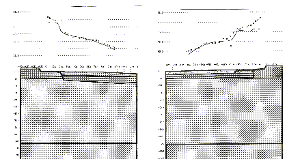
With the available geologic data described above, two-dimensional models were generated to explain the observed variation in gravity across the Liguanea Plain (Figure A3.5 and A3.6). In the modeling software, Grav2D, (Hurst, 1988) the user draws polygons representing rock or sediment units and then assigns density values representative of the rock type, which are either based on measured samples or average values. The program then calculates the predicted gravity anomaly based on the density contrast of the polygon with a background density of 2.67 g cm-3. In an iterative process, the user then changes the polygons' shape, location, and/or density, constrained by the independent geologic data, until a reasonable match is made to the observed gravity readings. There is no unique answer in this method of analysis, merely best-guesses that are consistent with the other data sources.
In order for the modeled gravity to be within 10 mgal of the observed data the subsurface polygons in both Figures A3.5 and A3.6, must extend well into the crust, where basalt densities are roughly 2.85-3.0 g cm-3. Each model includes a surface wedge of low-density, saturated sands and gravels, assigned a density of 2.0 g cm-3 (same density used in the Bouguer correction), which represents the Liguanea Plain alluvium. Below the alluvium polygon, outcrop data and previously published geologic maps (e.g., Meyerhoff and Kreig (1977)) indicate the presence of 1-2 km-thick carbonates (limestone and dolomite), which have an average density of 2.5-2.8 g cm-3. The limestone polygons underlying the alluvium in each model was assigned a representative density of 2.69 g cm-3. The same geologic maps indicate outcrops of denser igneous rocks (granodiorite and volcanics) to the north and east, but there is no subsurface control on these units. Geologic cross sections through Long and Dallas Mountains, published by Burke et al. (1980), show the White and Yellow limestone units but provide no deeper information. Crustal models by Wadge et al. (1983b) show the south coast geology, east of Kingston to be composed of Tertiary limestones (2.6 g cm-3) underlain by Tertiary sandstones and shales of slightly higher density (2.65 g cm-3).
The northern limestone in Figure A3.5 was assigned a value of 2.75 g cm-3 because of the inferred proximity of the higher density rocks. The east-west transect (Figure A3.6) passes north of Long Mountain and is associated with a relatively thin alluvial cover. Higher density carbonates, volcaniclastics, and granodiorite outcrop just east of the survey area, and are included in the model.
As was mentioned earlier, the steep topographic drop near the +2 km mark along the north-south transect (Figure A3.5) corresponds with a significant decrease in the observed gravity. A blind, southerly dipping normal fault, with offset of approximately 200 m, was modeled to explain this trend. While the data fit is not perfect, a large proportion of the observed variance can be explained with this structure. However, the thickness of the alluvium, the primary target of the study, is not well constrained; a similar fit was observed with an alluvium polygon 50% larger than the one depicted in Figure A3.5. The gravity gradient observable in the east-west transect (Figure A3.6) is also probably a function of both a westerly thickening wedge of alluvium, but more importantly the high density rocks to the east that may project west into the subsurface.
Given the inherent uncertainty in the two-dimensional gravity model and the paucity of geologic data for control, an alternate method for estimating thinkness of the alluvium was employed: calculation of overburden. In this method, the deep subsurface structure is ignored, and it is assumed that the gradient observed in the gravity data is primarily controlled by changes in the relative thickness of low-density material (alluvium) near the surface.
The maximum gravity variation, Dgmax, resulting from a sudden change in overburden thickness is given by
Dgmax = 0.042 DrD
where Dr is the density contrast, and D is the overburden thickness in meters (after Telford et al., 1990). The thickness of overburden can be written as
D = 23.86 Dgmax/Dr
For example, if Dgmax = 10 mgal and Dr
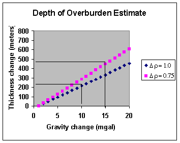
= 0.75 gm/cc, the difference in thickness, D, is 318 meters The density difference between Liguanea alluvium and limestone ranges from 0.7 to 1.0 g cm-3 (see Table A3.3). Figure A3.7 illustrates the change in overburden thickness as a function of change in gravity for density contrasts of 0.7 and 1.0 g cm-3.Using the gravity/depth observations at the Campion College well as a reference point (station CAMP, 76.006 mgal/ 182.2 m), the difference in gravity between Campion College and Ocean Boulevard (station NS25) is 15.3 mgal [76 - 60.7 mgal]. As seen in Figure A3.8, this difference in gravity is equivalent to an overburden thickness change of between 365 to 521 meters, depending on the density contrast chosen. The total alluvial thickness beneath Ocean Boulevard at Kingston Harbor is estimated to be between 548 to 704 meters [Campion College depth + calculated depth change]
Gravity/depth observations at Kings House (station W001, 72.56 mgal/131.2 m) and Constant Spring Golf Course (station CSPR, 81.35 mgal/62.4 m) yield similar total thickness estimates at Kingston Harbor (414 to 535 m and 555 to 766 m, respectively).
The gravity survey conducted in June 1998 provided the first detailed data set of observed Bouguer anomaly values from the Liguanea Plain. Two-dimensional models generated from the Bouguer anomalies are inconclusive, but they give an estimated alluvium thickness of less than 100 m in the north portion of the survey area, thickening to approximately 500-600 m near Kingston Harbor. From east to west, there is little change in the thickness of the unit, approximately 300-400 m. Using the observed gradient in Bouguer anomaly values, the maximum thickness of the alluvium is estimated to be between 500 and 700 m based on a simplified overburden calculation.
Suggestions for further study
Station Name |
Latitude |
Longitude |
Elev. |
Observed Gravity |
Std. Dev. |
Free-Air Anomaly |
Bouguer Anomaly (2.67 g cm-3) |
Bouguer Anomaly |
Terrain Correction |
Adjusted Bouguer Anomaly |
EW01 |
18.01542 |
76.74275 |
216.947 |
978555.964 |
0.036 | 97.055 |
72.768 |
78.863 |
3.366 |
82.229 |
EW02 |
18.01594 |
76.74561 |
208.465 |
978557.061 |
0.037 |
95.507 |
72.170 |
78.026 |
2.946 |
80.972 |
EW03 |
18.01633 |
76.74861 |
200.568 |
978558.551 |
0.038 |
94.540 |
72.087 |
77.721 |
2.660 |
80.381 |
EW04 |
18.01686 |
76.75158 |
191.734 |
978559.701 |
0.037 |
92.935 |
71.471 |
76.857 |
2.494 |
79.351 |
EW05 |
18.01742 |
76.75447 |
181.324 |
978561.138 |
0.036 |
91.130 |
70.831 |
75.925 |
2.363 |
78.288 |
EW06 |
18.01808 |
76.75769 |
173.093 |
978563.078 |
0.036 |
90.495 |
71.118 |
75.980 |
2.394 |
78.374 |
EW07 |
18.01869 |
76.75922 |
161.399 |
978564.793 |
0.035 |
88.569 |
70.501 |
75.035 |
2.440 |
77.475 |
EW07A |
18.01956 |
76.76561 |
149.636 |
978567.485 |
0.035 |
87.574 |
70.833 |
75.036 |
2.241 |
77.277 |
EW08 |
18.02042 |
76.76844 |
138.479 |
978569.396 |
0.034 |
86.007 |
70.505 |
74.395 |
2.140 |
76.535 |
CAMP |
18.01908 |
76.76964 |
133.218 |
978570.056 |
0.027 |
85.115 |
70.202 |
73.944 |
2.062 |
76.006 |
EW09 |
18.02089 |
76.77222 |
133.734 |
978570.838 |
0.034 |
85.959 |
70.988 |
74.745 |
2.030 |
76.775 |
EW10 |
18.02183 |
76.77694 |
125.072 |
978570.575 |
0.034 |
82.973 |
68.972 |
72.485 |
1.968 |
74.453 |
EW11 |
18.02231 |
76.78019 |
115.820 |
978570.935 |
0.030 |
80.452 |
69.926 |
72.568 |
1.923 |
74.491 |
EW12 |
18.02328 |
76.78508 |
104.867 |
978572.256 |
0.032 |
78.342 |
66.602 |
69.548 |
1.839 |
71.387 |
W001 |
18.01994 |
76.78147 |
117.500 |
978570.527 |
0.032 |
80.689 |
67.535 |
70.836 |
1.724 |
72.560 |
EW13 |
18.02386 |
76.78939 |
95.061 |
978574.624 |
0.031 |
77.653 |
67.011 |
69.682 |
1.761 |
71.443 |
EW14 |
18.02417 |
76.79444 |
82.985 |
978575.704 |
0.030 |
74.989 |
65.699 |
68.030 |
1.603 |
69.633 |
EW15* |
18.02472 |
76.79617 |
83.067 |
978575.837 |
0.026 |
75.119 |
65.820 |
68.153 |
1.576 |
69.729 |
EW16 |
18.02531 |
76.80019 |
74.336 |
978577.304 |
0.030 |
73.859 |
65.537 |
67.625 |
1.500 |
69.125 |
EW17 |
18.02639 |
76.80400 |
70.988 |
978578.265 |
0.030 |
73.730 |
65.783 |
67.777 |
1.475 |
69.252 |
EW18 |
18.02697 |
76.80731 |
65.875 |
978579.532 |
0.030 |
73.388 |
66.013 |
67.864 |
1.465 |
69.329 |
EW19 |
18.02686 |
76.81122 |
58.487 |
978581.055 |
0.034 |
72.637 |
66.090 |
67.732 |
1.438 |
69.170 |
EW20 |
18.02833 |
76.81378 |
55.084 |
978581.883 |
0.034 |
72.336 |
66.169 |
67.717 |
1.458 |
69.175 |
EW21 |
18.02597 |
76.81786 |
46.513 |
978582.429 |
0.033 |
70.362 |
65.155 |
66.462 |
1.386 |
67.848 |
EW22 |
18.02522 |
76.82153 |
41.384 |
978582.496 |
0.033 |
68.886 |
64.253 |
65.416 |
1.377 |
66.793 |
EW23 |
18.02542 |
76.82631 |
32.519 |
978583.709 |
0.033 |
67.353 |
63.713 |
64.626 |
1.431 |
66.057 |
EW24 |
18.02564 |
76.83103 |
24.964 |
978585.090 |
0.034 |
66.390 |
63.595 |
64.297 |
1.519 |
65.816 |
EW25 |
18.02578 |
76.82444 |
19.872 |
978585.928 |
0.034 |
65.649 |
63.424 |
63.983 |
1.580 |
65.563 |
NS25 |
17.96389 |
76.79456 |
0.386 |
978583.030 |
0.024 |
60.017 |
59.974 |
59.985 |
0.753 |
60.738 |
NS24 |
17.96625 |
76.79494 |
0.294 |
978583.294 |
0.024 |
60.128 |
60.095 |
60.103 |
0.771 |
60.874 |
NS23 |
17.97067 |
76.79350 |
9.482 |
978582.603 |
0.024 |
62.038 |
60.976 |
61.243 |
0.823 |
62.066 |
NS22 |
17.97403 |
76.79311 |
14.638 |
978581.984 |
0.024 |
62.832 |
61.193 |
61.604 |
0.858 |
62.462 |
NS21 |
17.97739 |
76.79378 |
23.304 |
978581.098 |
0.024 |
64.444 |
61.835 |
62.490 |
0.878 |
63.368 |
NS20 |
17.98125 |
76.79294 |
34.248 |
978579.963 |
0.024 |
66.482 |
62.648 |
63.610 |
0.921 |
64.531 |
NS19 |
17.98467 |
76.79239 |
38.907 |
978579.697 |
0.024 |
67.473 |
63.117 |
64.210 |
0.970 |
65.180 |
NS18 |
17.98781 |
76.79461 |
44.058 |
978579.136 |
0.025 |
68.335 |
63.403 |
64.640 |
0.982 |
65.622 |
NS17 |
17.99211 |
76.79397 |
48.611 |
978578.470 |
0.020 |
68.846 |
63.404 |
64.770 |
1.040 |
65.810 |
NS16 |
17.99756 |
76.79436 |
60.284 |
978576.578 |
0.023 |
70.268 |
63.519 |
65.213 |
1.109 |
66.322 |
NS15 |
18.00139 |
76.79539 |
64.735 |
978576.146 |
0.022 |
70.123 |
62.876 |
64.695 |
1.410 |
66.105 |
NS14 |
18.00425 |
76.79486 |
69.989 |
978575.412 |
0.021 |
71.744 |
63.909 |
65.875 |
1.187 |
67.062 |
NS13 |
18.00767 |
76.79600 |
74.567 |
978575.034 |
0.014 |
72.597 |
64.249 |
66.344 |
1.219 |
67.563 |
NS12 |
18.01033 |
76.79761 |
71.056 |
978575.349 |
0.022 |
71.687 |
63.732 |
65.729 |
1.245 |
66.974 |
NS11 |
18.01417 |
76.79769 |
73.674 |
978575.792 |
0.026 |
72.734 |
64.486 |
66.556 |
1.306 |
67.862 |
NS10 |
18.01792 |
76.79636 |
76.357 |
978575.262 |
0.026 |
72.834 |
64.286 |
66.431 |
1.390 |
67.821 |
NS09 |
18.02103 |
76.79642 |
80.542 |
978575.656 |
0.026 |
74.354 |
65.338 |
67.600 |
1.471 |
69.071 |
NS08* |
18.02472 |
76.79617 |
83.067 |
978575.837 |
0.026 |
75.119 |
65.820 |
68.153 |
1.576 |
69.729 |
NS07 |
18.02842 |
76.79608 |
90.633 |
978575.191 |
0.026 |
76.611 |
66.465 |
69.011 |
1.632 |
70.643 |
NS06 |
18.03358 |
76.79586 |
107.350 |
978574.622 |
0.026 |
80.917 |
65.816 |
69.606 |
1.729 |
71.330 |
NS05 |
18.03814 |
76.79469 |
121.923 |
978574.945 |
0.026 |
85.506 |
71.875 |
75.282 |
1.886 |
77.168 |
NS04 |
18.04081 |
76.79481 |
134.324 |
978574.455 |
0.026 |
88.701 |
73.664 |
77.437 |
1.993 |
79.430 |
NS03 |
18.04347 |
76.79411 |
138.780 |
978573.919 |
0.026 |
89.399 |
73.863 |
77.761 |
2.060 |
79.821 |
CSPR |
18.04906 |
76.79219 |
149.925 |
978572.984 |
0.026 |
91.607 |
74.823 |
79.035 |
2.314 |
81.349 |
NS02 |
18.04819 |
76.79428 |
140.860 |
978574.396 |
0.027 |
90.267 |
74.498 |
78.455 |
2.190 |
80.645 |
NS01 |
18.05100 |
76.79344 |
150.154 |
978573.198 |
0.027 |
91.788 |
74.979 |
79.197 |
2.382 |
81.579 |
PIER_H |
17.96350 |
76.78967 |
2.000 |
978583.325 |
0.009 |
60.831 |
60.607 |
60.663 |
0.806 |
61.469 |
PIER_3 |
17.96167 |
76.78083 |
2.200 |
978582.845 |
0.009 |
60.509 |
60.263 |
60.324 |
0.891 |
61.215 |
| CDMP home page: http://www.oas.org/en/cdmp/ | Project Contacts | Page Last Updated: 20 April 2001 |