Wave Hazard Assessment for Selected Sites on the West Coast of Dominica, West Indies


| Back to: Wave Hazard Assessment for Selected Sites on the West Coast of Dominica, West Indies |
Back to: | |
|
The WES Spectral Wave Model produces wave height, wave power, and other storm characteristics for each finite element cell of the input map. The entire coastline is modeled simultaneously, but the volume of output data is difficult to comprehend. Following is a discussion of only six points along the coast and the results at those points. These points are selected because they were damaged during the storms of 1995 and they demonstrate the local effects of an indented, rocky shore.
The sea wall by the Roseau Public Library cracked and collapsed in places during Hurricane Marilyn in 1995. The Library is atop a bluff, approximately 10 meters above a narrow cobblestone beach. Below the waterline, the ground slopes steadily down with a southwestern aspect. There is ordinarily some swell here, due to diffracted waves from the Martinique Channel which come around Scotts Head.
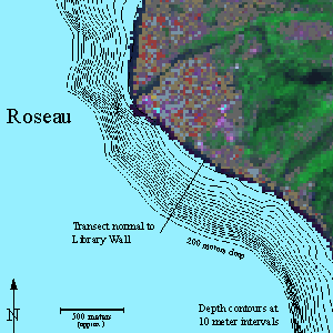
The deep-water harbour just north of Roseau is the main port of the island. It is usually quite sheltered, since it is nearly a third of the way up the leeward side, with a well-formed cove. It is not a shelter, however, when winds and seas come out of the west, during cyclonic storms, The depth of the water in the center of the cove allows storm waves to approach closely, and the shape of the cove may focus wave energy rather than dissipate it.
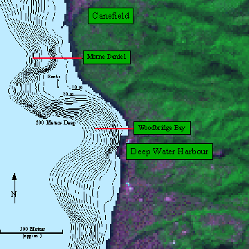
In the section of coast from the deep water harbour to Canefield (previous page), the first transect shown leads from the deep water to the most sheltered part of Woodbridge Bay, between the port facilities and the boat landing where the local fishing fleet pulls up. There is a sandy beach and a small jetty, not visible at this scale. The coastal road runs along an embankment about 3 meters high, just inland from the beach. The embankment is reinforced with gabions.
The second transect leads from the deep water, between two reef areas, to an exposed part of the coastal road below the cliffs of Morne Daniel. The road runs atop a masonry wall about 3 meters high, but so close to the water that there are sections where the edge of the pavement is eroding into the sea.
The transect for Morne Daniel runs across an area where the bottom configuration corresponds to especially severe hazards. Sections immediately north and south of the transect receive some protection from submerged rocks and reefs.
That protection is only relative, however, and the entire peninsula experienced damage along the shore in 1995.
The map on the next page shows a stretch of coast about two-thirds of the way up the leeward coast. Villages such as Coulibistri sit at the mouth of small river valleys. Except for the valleys, the coast is steep, with cliffs above the water line and a narrow shelf below. The sea wall for the coast road is mostly gabions, and numerous gabions were undermined, shifted, or broken open in 1995.
The transect for Coulibistri leads up the middle of a notch in the underwater shelf. This notch may be due to underwater landslides or to turbidity erosion. The result is that the shelf is especially narrow at this point, and the storm damage showed a local maximum just in front of the village. Reflected waves off of the steep shore at Grande Savanne may be a factor as well.
The bathymetry study which was done as part of this modeling project found several places along the coast with this sort of steep underwater depression. Preliminary observations indicate that these underwater notches are associated with problem areas for storm damage.
Gueule de Lion is just north of Coulibistri. The shoreline is relatively straight, the coastal shelf is narrow, and the natural shore is rocky and steep. The coastal road runs near to the sea atop an embankment reinforced with gabions and occasional lengths of masonry sea wall. Water two meters deep comes to the bottom of the embankment, in places. There was extensive damage to the gabions along this stretch in 1995.
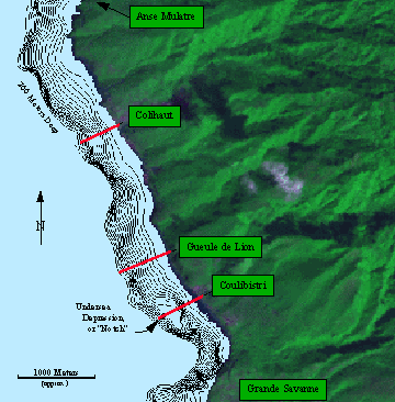
North of Gueule de Lion, the road turns inland and climbs over headlands. It comes down again near a stone quarry and jetty, and runs parallel to the shore until Colihaut, where it turns inland again. That turn in the road was severely damaged, with the gabions twisted and collapsed and the pavement gone for about fifty meters. The public school is on level ground near the shore and near the road damage.