Caribbean Disaster
Mitigation Project
Implemented by the Organization of American States
Unit of Sustainable Development and Environment
for the USAID Office of Foreign Disaster Assistance and the Caribbean Regional Program


Caribbean Disaster
Mitigation Project |
|
Bulletin Date: December 1999
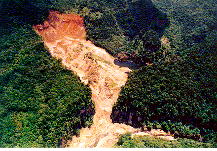 In the fall
of 1997, a series of landslides blocked the upper portion of the Layou River in Dominica.
Failure of the resulting landslide dam has the potential to cause potentially disasterous
flash flooding in the lower reaches of the Layou valley. To assist the Government of the
Commonwealth of Dominica (GOCD) in responding to the risk of flooding in the Layou River
valley caused by the landslide dam, the Caribbean Disaster Mitigation Project (CDMP)
organized a technical assistance team, consisting of Dr. Cassandra Rogers, a landslide
expert from the University of the West Indies (UWI) in Trinidad and Dr. David Lang, a
geologist resident in Dominica. Coordination with Government's Layou Landslide Dam and
Flood Events Task Force was supported by Mr. Paul Brown, Director of the OAS Office in
Dominica. In a January 1998 meeting with the Cabinet of Ministers, it was agreed that the
CDMP would assist the Government in the following priority areas: 1) the development of a
detailed plan of action for a vulnerability assessment and mitigation actions in the lower
Layou River, 2) setting a framework for evacuation decisionmaking, 3) development of a
long-term landslide hazard risk assessment and response plan, and 4) evaluation of the
suitability of river bed sediments for use as construction materials. Shortly after this
meeting, the team assessed proposed emergency vulnerability reduction measures and
developed a detailed plan of action for flood vulnerability assessment and mitigation.
In the fall
of 1997, a series of landslides blocked the upper portion of the Layou River in Dominica.
Failure of the resulting landslide dam has the potential to cause potentially disasterous
flash flooding in the lower reaches of the Layou valley. To assist the Government of the
Commonwealth of Dominica (GOCD) in responding to the risk of flooding in the Layou River
valley caused by the landslide dam, the Caribbean Disaster Mitigation Project (CDMP)
organized a technical assistance team, consisting of Dr. Cassandra Rogers, a landslide
expert from the University of the West Indies (UWI) in Trinidad and Dr. David Lang, a
geologist resident in Dominica. Coordination with Government's Layou Landslide Dam and
Flood Events Task Force was supported by Mr. Paul Brown, Director of the OAS Office in
Dominica. In a January 1998 meeting with the Cabinet of Ministers, it was agreed that the
CDMP would assist the Government in the following priority areas: 1) the development of a
detailed plan of action for a vulnerability assessment and mitigation actions in the lower
Layou River, 2) setting a framework for evacuation decisionmaking, 3) development of a
long-term landslide hazard risk assessment and response plan, and 4) evaluation of the
suitability of river bed sediments for use as construction materials. Shortly after this
meeting, the team assessed proposed emergency vulnerability reduction measures and
developed a detailed plan of action for flood vulnerability assessment and mitigation.
During 1998, the water impoundment behind the landslide dam on the Mathieu River stabilized. Water that accumulated behind the dam was seeping into the soil and under the dam with no visible deterioration of the dam itself. To assist with continuous monitoring of landslide activity and movement of the landslide dam, the CDMP contracted the UWI Seismic Research Unit to install a seismometer at the foot of the slide. The local officials assigned to monitor the dam have been equipped with handheld radios so that sudden movements of dam material or any seismic activity can be detected. A drum seismograph was installed in the Layou village Police station, with radio link to the seismometer, for additional monitoring of the situation.
A more detailed analysis of the flood hazard posed by a landslide dam break was also undertaken by Dr. Rogers, with the support of CDMP. A Geographic Information System (GIS) model was prepared to serve as a basis for analyzing possible dam failure and lower Layou river flooding scenarios. Detailed contour information was digitized for the lower Layou River for use in this GIS model. The existing Geographic Information System/Environmental Planning project in Dominica has also been refocused, where possible, to support response to the landslides and landslide dams in the Layou River valley.
The final results of the flood hazard model were presented in Dominica in early 1999, completing CDMP's post-disaster mitigation mission in the Layou River valley.
[Photo credit: David Lang]
| CDMP home page: http://www.oas.org/en/cdmp/ | Project Contacts | Page Last Updated: 20 April 2001 |