Caribbean Disaster
Mitigation Project
Implemented by the Organization of American States
Unit of Sustainable Development and Environment
for the USAID Office of Foreign Disaster Assistance and the Caribbean Regional Program


Caribbean Disaster
Mitigation Project |
|
Bulletin Date: December 1999
During the week of 1 March 1999, the Caribbean Disaster Mitigation Project hosted a four-day regional workshop on Natural Hazard Mapping and Vulnerability Assessment. Over 30 physical planners and disaster coordinators from throughout the Caribbean met to review the development of hazard maps for the major natural hazards that affect the Caribbean, the use of these maps to develop assessments of vulnerability of life and property to these hazards and the incorporation of this hazard information into development planning and control and emergency management. This workshop is a follow-up to the Hazard Mitigation Planning workshop, which was held in St. Lucia in July 1997 and co-sponsored by CDMP and the Caribbean Disaster Emergency Relief Agency (CDERA).
 The objectives of the Natural Hazard Mapping and Vulnerability
Assessment workshop were to 1) demonstrate the importance of incorporating hazard
maps into planning decisions; 2) provide sufficient information on individual hazards to
understand and use maps of those hazards; and 3) guide the use of this hazard information
in planning and decisionmaking through vulnerability assessment and multi-hazard analysis.
In bringing together disaster managers and physical planners from throughout the region,
additional benefits were realized through furthering dialogue both between these
professions and within the region on hazard mapping and vulnerability assessment.
The objectives of the Natural Hazard Mapping and Vulnerability
Assessment workshop were to 1) demonstrate the importance of incorporating hazard
maps into planning decisions; 2) provide sufficient information on individual hazards to
understand and use maps of those hazards; and 3) guide the use of this hazard information
in planning and decisionmaking through vulnerability assessment and multi-hazard analysis.
In bringing together disaster managers and physical planners from throughout the region,
additional benefits were realized through furthering dialogue both between these
professions and within the region on hazard mapping and vulnerability assessment.
During the workshop, a matrix of existing hazard maps in the Caribbean was compiled. A final workshop report is forthcoming. Materials from this workshop are available on the CDMP hazard mapping resources page.
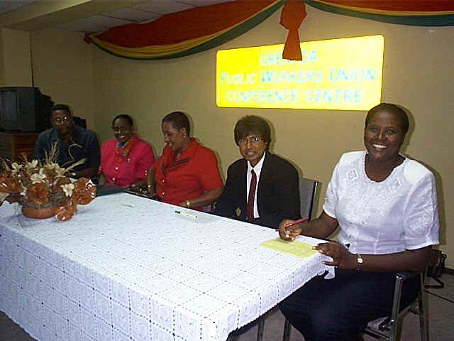
[Picture: Head table at the opening ceremony for the workshop. l to r. Francis McBarnette (Director OAS Grenada), Judy Thomas (CDERA), Claris Charles (Minister of State in the Grenada Prime Minister's office), Sterling Mungal (USAID/Office of Foreign Disaster Assistance) and Joyce Thomas (Grenada National Disaster Coordinator). Photo credit: Timothy James]
The workshop focused on natural hazard mapping and vulnerability assessment. The workshop agenda was divided into four modules:
Use of hazard maps and vulnerability assessments in development planning
Hazards discussed at the workshop included both geologic (earthquakes, tsunamis, volcanoes, landslides) and hydrometeorologic (hurricanes/coastal storms, floods) hazards. On the last day, case studies of hazard mitigation planning activities in selected countries were also presented.
The workshop began with a full-day, general introduction to each of the hazards to be covered in the workshop, including information on the occurrence, mechanics, frequency, intensity, distribution and relative economic, social and environmental impact of each of these hazards in the region. The module was intended to give all participants a common, broad understanding of natural hazards in the Caribbean.
This module began with an introduction to mapping concepts common to all hazards, such as hazard, mapping, assessment and vulnerability. For each hazard, the following topics were discussed:
Use of geographic information systems (GIS)
Throughout these presentations, the importance of incorporating hazard maps into planning decisions was stressed. Case studies of the economic, social and environmental consequences of incorporating vs not incorporating hazard data were presented when available. For a number of hazards, new or soon-to-be completed information was presented, including:
A discussion of the Kick 'em Jenny Tsunami Early Warning system to be installed in Grenada by the Seismic Research Unit with funding from the Caribbean Development Bank
This module covered the use of this hazard mapping background (module 2) in vulnerability assessments. In addition to information on the individual hazards, vulnerability assessment requires information on what is vulnerable, including population, facilities, services, economic activities and natural resources. Special considerations for vulnerability information (e.g. use of census information for populations) were also discussed. The methodology presented was recently developed by the US NOAA Coastal Services Center. The Coastal Services Center is also developing a guidebook to describe this methodology; this document will be available later this year. The vulnerability assessment presentation used at the Grenada workshop is available for download [MS Powerpoint, 8.5 megabytes].
Hazard vulnerability assessments can be used in the development of many types of national and local plans, such as plans for physical development, economic development or emergency management. The final session of the workshop was an interactive session, with the objective of 1) agreeing on the relative importance of hazards and their impact in planning decision-making and 2) developing a common approach to incorporating them into current practices. Workshop participants were divided into groups to develop scenarios of ideal structures for implementing a hazard reduction program and to propose actions for reducing hazard vulnerability in a selected country.
 Hazard
Mitigation Planning
Hazard
Mitigation PlanningTo follow up on the themes of the 1997 CDMP/CDERA hazard mitigation planning workshop, case studies of mitigation planning were presented on mitigation planning efforts in the British Virgin Islands, Barbados and Jamaica [MS PowerPoint presentations, 270k, 80k and 250k, respectively.] The British Virgin Islands' presentation focused on the results of its Hazard and Risk Assessment Project, which was completed in 1997.
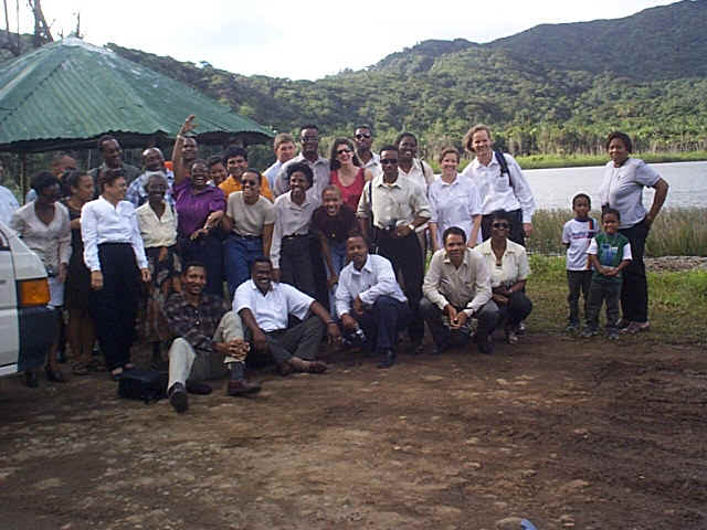
The workshop closed with a field trip through the Grand Etang Forest Reserve and around the southern side of Grenada. [Photo credit: Timothy James]
| CDMP home page: http://www.oas.org/en/cdmp/ | Project Contacts | Page Last Updated: 20 April 2001 |