Seismic Research Unit
The University of the West Indies
St. Augustine
Trinidad and Tobago
Volcanic-hazard assessment for St. Kitts, Lesser Antilles
By K. Simpson, Volcanologist
and
John B. Shepherd, Seismologist
July 2001

Volcanic eruptions have killed over 30,000 people in the Lesser Antilles this century and at present more than a quarter of a million people live on the flanks of active volcanoes in the region. Thus ongoing volcanic hazard assessment and monitoring of the volcanoes is essential to reduce the risk to lives and property.
This report is a volcanic hazard report for St. Kitts based on five weeks of field work (April 1st to May 8th 2001) and an extensive literature search of past research related to St. Kitts. Further field work and analytical data are ongoing. Only a brief visit to Nevis was undertaken during the first field visit to St. Kitts and observations made during that visit will be mentioned only briefly in this report.
The current research on St. Kitts and Nevis is part of a regional project at the Seismic Research Unit to assess the volcanic hazards for a number of the Caribbean islands including Dominica, St. Lucia, Saba, St. Eustatuis (Statia), St. Kitts and Nevis. Volcanic hazard assessment of Dominica is complete, work on St. Lucia is currently in progress and work on Saba and Statia is yet to be started. Funding for the St. Kitts and Nevis research is being provided by the Organization of American States (OAS) as part of the Post-Georges Disaster Mitigation Project.
Glossary of terms used in this report
Debris avalanches
A debris avalanche is a sudden and rapid movement of rock and other debris (e.g. vegetation) driven by gravity. It may result from the collapse of the side of an oversteepened volcano or gravitational collapse of unconsolidated sediments. Depending on their scale debris avalanches may destroy everything in their path. They can occur during volcanic eruptions or when a volcano is not actively erupting.
Eruption column collapse
Explosive eruptions generate abundant ash which is carried up into the atmosphere by expanding hot gases and produces a buoyant eruption column. The collapse of an eruption column occurs when the density of the volcanic particles entrained in the column exceeds the upward buoyancy of the column. The volcanic particles fall back down to the ground under the influence of gravity and can form pyroclastic flow, surge and fall deposits.
Effusive eruption
Effusive eruptions occur when molten rock (lava) reaches the Earth’s surface and erupts passively. The products of these eruptions are lava flows and domes. The Soufriere Hills Volcano in Montserrat has, since 1995, demonstrated this type of eruption.
Explosive eruptions – 3 types
Explosive eruptions involve the rapid expansion of gas causing the surrounding rock or magma to fragment explosively. There are 3 types of explosive eruptions:
Magmatic eruptions
Explosive magmatic eruptions occur when dissolved gases in a rising magma expand to form gas bubbles which then burst as the magma nears the Earth’s surface, leading to explosive fragmentation of the magma. The bigger fragments are ejected (balistically) like cannonballs while the smaller fragments are transported vertically by the expanding hot gas into the atmosphere to form a vertical eruption column. The products of an explosive magmatic eruption include pyroclastic fall, flow and surge deposits. In 1979, the eruption of the Soufriere volcano of St. Vincent developed from a phreatomagmatic stage into an explosive magmatic stage. Several magmatic explosions have occurred during the ongoing eruption of the Soufriere Hills in Montserrat.
Phreatomagmatic eruptions
Explosive phreatomagmatic eruptions occur when magma comes into contact with water causing the water to flash to steam. The expanding steam disrupts not only the pre-existing solid rock but also the magma itself so that the fragments thrown out are a mixture of broken-up old rocks and new rocks. The products of a phreatomagmatic eruption include pyroclastic fall, flow and surge deposits. The 1979 eruption of the Soufriere of St. Vincent began as a phreatomagmatic eruption and this is also the predominant eruption style of the Kick ‘em Jenny submarine volcano.
Phreatic eruptions
Phreatic eruptions occur when confined sub-surface geothermal waters are heated to temperatures above their boiling point and flash from water to steam. The resulting volume expansion and energy release drives the phreatic eruption. There is no direct involvement of magma in this style of eruption. These eruptions may eject steam, hot water, hot mud and/or hot and cold rock. In some cases the mud and water ejected may be acidic. In the Eastern Caribbean there have been numerous phreatic eruptions. The 1880 and 1997 eruptions in the Valley of Desolation in Dominica are examples of phreatic eruptions.
Fumaroles
Fumaroles are cracks or openings in the ground through which volcanic gases from beneath the Earth’s surface escape. Monitoring of fumaroles by analysing the gases and measuring temperatures may be useful in predicting volcanic eruptions. Volcanic gases may be hazardous to humans and animals and have in some cases caused death. Condensation of the gases into groundwater can result in alteration and dissolution of rock near the surface, making these areas prone to collapse or subsidence.
Hazard maps
Hazard maps are important tools in planning mitigation of the harmful effects of volcanic eruptions. They take several forms and most often show the areas around a volcano which are likely to be affected by different types of hazardous phenomena related to the volcano.
Lahars
Lahars are mudflows formed when volcanic particles mix with water. The source of the water may be a crater lake, heavy rain or snow. The loose ash and volcanic fragments are transformed into a dense fluid-rock mixture that rushes down the slopes of a volcano and into surrounding valleys. Lahars are destructive to everything in their path and the threat from lahars may last for years after the eruption has ended.
Lava flows and lava domes
Lava flows are hot streams of molten rock that travel down valleys on the slopes of volcanoes. The distance they travel depends on the viscosity (‘stickiness’) of the lava. If the lava is viscous (sticky) it cannot flow easily so it tends to form short thick lava flows or pile up around the vent to form a hill, or lava dome. Lava flows generally move slowly and therefore usually pose little hazard to humans, although they destroy everything in their path and can cause forest fires. However, viscous (sticky) lava flows and domes can be hazardous as their steep sides often become unstable and can collapse, causing small pyroclastic flows (block and ash flows). Lava flows are uncommon on the volcanoes of the Lesser Antilles but lava domes are abundant and their collapse has caused significant loss of life
Pyroclastic falls (ash falls)
Explosive volcanic eruptions produce fine material called volcanic ash, which is carried upwards in a buoyant eruption column before it settles out downwind. Ash falls can blanket the entire landscape for kilometres around a volcano, and may even reach nearby islands. Close to the eruption vent, ash may be thick enough to collapse buildings and destroy vegetation. Ash can threaten livestock and cause aircraft, ship and car engines to malfunction. They can also be very dangerous to people’s health since even the finest fractions of ash may cause serious respiratory problems if they are inhaled. This hazard may persist long after the eruption itself has ended.
Pyroclastic flows
A pyroclastic flow is a hot (100-600OC), fast-moving (>100 km/hr) mixture of ash, rock fragments and gas. Such flows form when an eruption column or a lava dome collapses. They usually travel down valleys and cause total devastation of the area over which they flow. People in the path of a hot pyroclastic flow can be killed by asphyxiation, heat and noxious gases. Pyroclastic flows have been the main cause of destruction and loss of life in Montserrat since 1995.
Pyroclastic surges
A pyroclastic surge is a dilute, turbulent cloud of gases and rock debris that moves above the ground surface at great speeds. Pyroclastic surges form in a similar way to pyroclastic flows, but their effects are more widespread as they are less confined by topography and may therefore sweep across ridges and hills as well as down valleys. Pyroclastic surges can be either hot (several hundred ° C) or cold (< 100 ° C). Cold pyroclastic surges are generally known as base surges, and are commonly generated by phreatic and phreatomagmatic explosions. The hazardous aspects of both types of surges include the destruction of vegetation and structures, impact damage by rock fragments, and burial by ash and rock debris. People in the path of a hot pyroclastic surge can also be killed by asphyxiation, heat and noxious gases. Pyroclastic flows and surges from Mt. Pele completely destroyed the town of St. Pierre in Martinique in 1902, killing about 30,000 people.
Volcaniclastic deposits
The term volcaniclastic is a general term describing any deposit that contains volcanic fragments regardless of the process by which it formed. It is often used when the interpretation of a particular deposit is unclear or undetermined. All pyroclastic deposits, lahar deposits and debris avalanche deposits are types of volcaniclastic deposits.
Volcanic earthquakes
Volcanic earthquakes always precede the onset of volcanic activity, although they do not always culminate in a volcanic eruption. Volcanic earthquakes are the most effective monitoring tool for predicting a volcanic eruption and they may, in themselves, be severe enough to cause significant damage. A sequence of volcanic earthquakes in Montserrat between 1931 and 1938 destroyed a large number of buildings.
Volcanic gases
Gases such as sulphur dioxide (SO2), carbon monoxide (CO) and hydrogen sulphide (H2S) are present in toxic amounts close to the vent of an erupting volcano and/or may be emitted from fumaroles. Further away from the vent they can become dissolved in atmospheric clouds to produce acid rain and mist which affect human and animal eyes and respiratory systems and corrode metal building materials. One of the most common volcanic gases, carbon dioxide (CO2), is not poisonous but nevertheless, it is extremely dangerous. As it is heavier than air it tends to accumulate in hollows in the ground, displacing the breathable air. Since it is invisible and has no taste or smell, people and animals are unable to notice that it is there and may suffocate. People have died in this way at the Boiling Lake in the Valley of Desolation in Dominica.
The islands of the Lesser Antilles form an arc along the eastern margin of the Caribbean sea that stretches ~700 km from Grenada in the south to Sombrero in the north (Figure 1). The arc represents the eastern boundary of the Caribbean plate which is underthrust by the North American plate. North of Dominica the arc is a double arc. The islands of the eastern arc (shown in black on Fig. 1) consist of Oligocene volcanic and plutonic rocks overlain by limestone and are often referred to as the ‘Limestone Caribbees’. The islands of the western arc (shown in red on Fig. 1) consist almost entirely of younger (Pleistocene) volcanic rocks and are called the ‘Volcanic Caribbees’. South of Dominica the two arcs converge and the islands are made up of Oligocene volcanic rocks overlain by limestone and capped by Pleistocene volcanic rocks.

There have been at least 8 historical eruptions of volcanoes in the Lesser Antilles but the number of volcanoes considered to be live is 18. Only one live submarine volcano has been identified in the region (Kick’em Jenny) and it is located ~9 km north of Grenada. It is the most frequently active of all the Lesser Antilles volcanoes, having erupted at least 11 times in the past 40 years.
The islands of St. Kitts and Nevis are situated in the northern region of the Lesser Antilles (Figure 1). St. Kitts is 176 square km in size with a population of ~36,000. The main part of the island has a mountain range that runs northwest through the center of the island. The higher mountain slopes are densely vegetated by rainforest. The foothills gently slope from the base of the mountain range to the coast and are largely covered by sugar cane. Mt. Liamuiga is the northwestern-most mountain and is the highest peak on the island at 1155 m (3792 ft). In contrast, the topography and vegetation of the Southern Peninsula is dramatically different. It consists of numerous low, round hills that reach a maximum height of 319 m (1047 ft), but are generally much lower and are separated by flat, low-lying areas and salt ponds. Vegetation is sparse with dryland grasses, low shrubs, cacti and yucca. The sharp contrast in both the topography and the vegetation from the north of the island is in part due to the older age of the rocks and the lower annual rainfall in the south. The capital of St. Kitts is Basseterre and it is located 12 km southeast of the summit of Mt. Liamuiga.
Nevis is 93 square km in size and has a population of ~9,000. It is an approximately circular island with a central mountain peak, Nevis Peak, which rises to 984 m (3232 ft). The higher slopes are covered by rainforest and the low-lying and coastal areas are covered by dry scrub. The capital, Charlestown, is situated at the base of the volcano in the southwest of the island.
The first detailed research in the Lesser Antilles was on the 1902 eruption in St. Vincent and Martinique (Anderson and Flett, 1903; Lacroix, 1904). Since then all the islands of the Lesser Antilles have been studied in varying detail. St. Kitts has been studied by numerous researchers and a complete reference list is included at the back of this report.
Martin-Kaye (1959) was the first to identify four volcanic centres on the island and produced the first geological map of St. Kitts. He concluded that the four volcanic centres became progressively younger towards the northwest and included (from south to north) the Salt Pond Peninsula, South East Range, Middle Range and Mt. Liamuiga. Baker (1963) undertook a PhD thesis focusing on the geology and geochemistry of St. Kitts and numerous publications followed including Baker (1965; 1968; 1969; 1980; 1985), Baker and Holland (1973). Smith et al. (1979) and Roobol et al. (1981) were the first to identify pyroclastic flow and surge deposits on St. Kitts and since then a number of publications have focused on the detailed description of such deposits (e.g. Roobol et al., 1987; Tate and Wilson, 1988). Baker (1985) discussed the volcanic hazards of St. Kitts and constructed a hazard map for the island. The aims of the present project are to build on the previous work and provide an updated volcanic hazard map.
Historic eruptions on St. Kitts
There have been two unsubstantiated reports of historic eruptions of Mt. Liamuiga in 1692 and 1843. The first report was by a Franciscan friar (Sloane, 1694) who describes the island as being troubled by earthquakes and mentions an eruption "of a Great Mountain of Combustable Matter". The second report comes from Capadose (1845) who describes a white spiral cloud of smoke and bubbling sulphurous springs from the crater of Mt. Liamuiga. There are no other historical reports to support the occurrence of either eruption and both of these alleged eruptions happened immediately after major earthquakes. It is possible that the effects of the earthquakes were confused with genuine eruptions or that the earthquakes could have triggered minor eruptions.
Small earthquakes occur at shallow depth close to most of the live volcanoes of the Eastern Caribbean. Occasionally the rate of occurrence of these earthquakes increases significantly and these periods of increased activity are called earthquake swarms. Most volcanic eruptions in the Lesser Antilles in historical time have been preceded by earthquake swarms so that monitoring of local seismic activity is one of the most important volcanic surveillance techniques.
Although most eruptions are preceded by earthquake swarms it does not follow that all earthquake swarms are followed by eruptions. In most islands there have been a number of earthquake swarms which have simply died away without any other symptom of volcanic activity. Nevertheless each earthquake swarm is treated as a potential volcanic crisis and the level of surveillance intensified whenever they occur. The normal, background rate of activity varies from volcano to volcano. Mt Liamuiga has been monitored continuously by a single short-period seismograph station at Bayfords Farm 8 km southeast of the crater since 1957. From the records of this station it has been established that the normal or background rate of occurrence of small earthquakes is about one per month. Since 1957 there have been two major earthquake swarms associated with Mt. Liamuiga and a number of minor ones. The first swarm occurred between 8-11 August 1974 when 21 small earthquakes occurred beneath the volcano. At the time there was only one seismograph in operation and the swarm died away before the monitoring system could be reinforced.
On October 24 1988 another earthquake swarm began and rapidly built up to a climax on October 26 when 186 earthquakes were recorded. In comparison with volcanic earthquakes recorded in other islands of the Lesser Antilles these earthquakes were extremely large. The two biggest events which occurred on the morning of October 26 were of magnitude 4.3 and 4.5 which is bigger than any of the earthquakes which preceded the eruption in St. Vincent in 1979 and Montserrat in 1995. On this occasion the single station was reinforced by additional stations in St. Kitts and in Statia. The earthquakes also were sufficiently large to be recorded by other seismograph stations throughout the Leeward Islands. Location of the thirty biggest earthquakes of the swarm are shown in figure 2.
Although this particular earthquake swarm did not culminate in a volcanic eruption it clearly indicated that the volcano is still live – i.e. that it is certainly going to erupt at some time in the future. Other signs that the volcano is still live include active fumaroles in the summit crater.
At the present time the rate of earthquake activity in St. Kitts is elevated above the background historical level but has not yet reached the level which could be described as a swarm. Figure 3 shows monthly numbers of earthquakes since January 2000.
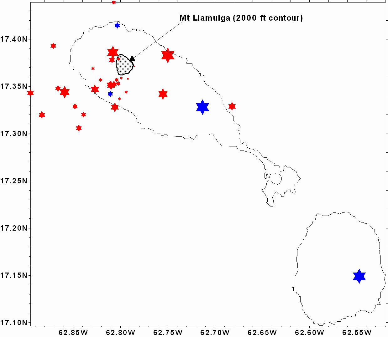
Red stars show locations of the biggest earthquakes. Blue stars are seismograph stations. The two bigger blue stars are permanent stations. Smaller stars were installed to study this swarm.Figure 2: the 1988-89 earthquake swarm.
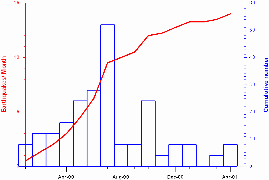
Figure 3: monthly earthquake numbers since January 2000.
There were 57 local earthquake in the 16 months between January 2000 and April 2002, which is a rate of a little less than four per month or nearly four times the normal background rate. During the first half of the year 2000 the rate of earthquake activity appeared to be escalating and this escalation was one of the triggers for this study. Although rates have now dropped back there is a clear need for preparedness for future eruptions.
There are four volcanic centers on St. Kitts, three of which are no longer considered live including, the Salt Pond Peninsula, SE Range, and the Middle Range (Martin-Kaye, 1959). A brief description of the eruptive history for each of the four volcanic centers is provided below.
The Salt Pond Peninsula is dominated by lava domes with minor undifferentiated volcaniclastic deposits that are likely debris avalanche and/or pyroclastic deposits. Due to the limited preservation of these deposits a definitive interpretation is difficult. Some units have characteristics of pyroclastic flow deposits (block and ash flow deposits) which form during the collapse of lava domes. The paucity of volcaniclastic deposits such as pyroclastic deposits may in part be due weathering and erosion. Lava domes are more resistant to weathering than poorly- to un-consolidated deposits such as pyroclastic flow, fall and surge deposits.
Previous age dating of lava domes in this area indicates ages of 2.3 ± 0.6 Ma (Baker, 1969). These ages are the oldest known for volcanic deposits on the island of St. Kitts. There are no known active fumaroles or hot springs in this area and the present topography is the result of weathering and erosion.
The South East Range is a youthful looking volcano that rises to a height of 900 m (2953 ft) and has a partly preserved crater at its summit (Baker, 1969). Ottley’s Level and Monkey Hill are two lava domes that formed on the flanks of the volcano. The South East Range is poorly exposed and thus very little is known about its past eruptive history. It mainly consists of lava flows and volcaniclastic deposits (Baker, 1969). An approximate age of 1 Ma years was obtained from a lava flow from the southern slopes of the South East Range (Baker, 1984).
The Middle Range rises to a height of 975 m (3200 ft) and also has a youthful appearance. It is poorly exposed and there appears to be no descriptions of its geology other than that it is similar to the South East Range (Baker, 1969). There are no age dates available for the Middle Range.
Mt. Liamuiga rises to a height of 1155 m (3792 ft) and it has a summit crater ~900 m wide and 244 m deep. The summit of Mt. Liamuiga exposes remnant lava flows or domes but the most common deposits identified on the lower flanks of Mt. Liamuiga are pyroclastic deposits. Cliff exposures along the coastline reveal 10-15 m thick successions of pyroclastic deposits (fall, flow and surge deposits), debris avalanche deposits and lahar deposits. Lava domes are prominent on the flanks of the volcano at Brimstone Hill, Sandy Point Hill and Farm Flat. There are also apparently two explosion craters located on Burke’s Estate (Baker, 1965) although these could not be located during this study. Age dates on deposits interpreted to have been erupted from Mt. Liamuiga range from 1620 to > 41,000 yrs BP. These are the youngest known deposits on the island.
Active fumaroles occur in the crater of Mt. Liamuiga, along the coast below Brimstone Hill and along the base of Brimstone Hill.
Future eruptions of Mt. Liamuiga and associated hazards
Present and past studies indicate that the northern part of St. Kitts in the vicinity of Mt. Liamuiga is the most likely location for future eruptions. The most likely styles of eruption interpreted from the past eruptive products are explosive magmatic eruptions resulting in pyroclastic flows, fall and surges and effusive eruptions of lava resulting in the formation of lava domes and pyroclastic flows (block and ash flows) from dome collapse events.
Explosive (magmatic) eruptions
Explosive magmatic eruptions involve the fragmentation of lava due to gas expansion. They produce buoyant eruption clouds which can collapse resulting in the formation of pyroclastic flows, fall and surges.
In the event of an eruption column collapse from an explosive eruption of Mt. Liamuiga the resulting pyroclastic flows will travel radially down the flanks of the volcano, initially being confined to valleys, and then spread out onto the broad, open and gentle slopes towards the sea. Much of the material may in fact enter the ocean forming new land. Pyroclastic flows are hot (> 100 degrees) and travel at speeds > 100 km/hr. They will bury anything in their path as well as burn vegetation. Accompanying the pyroclastic flows may be pyroclastic surges and pyroclastic fallout (ash fall). Pyroclastic surges are similar to pyroclastic flows in that they are hot and travel at great speeds. However, they are not confined to topographic lows and can overrun topographic highs, thus they may affect a wider area than the pyroclastic flows. Ash fall will be controlled by the dominant wind direction and may travel for kilometers and affect neighboring islands and disrupt air traffic. The ash fall will be thickest close to the vent and will decrease in thickness away from the vent. The ash is hazardous to the health of humans and animals and it may cause the collapse of buildings.
The most likely location for a magmatic eruption is at the present summit of Mt. Liamuiga. Figure 4 is a preliminary volcanic hazard map of St. Kitts and illustrates the hazard zones for the entire island in the event of an explosive magmatic eruption from the crater of Mt. Liamuiga.
Effusive eruptions (lava domes/flows)
Effusive eruptions are non-explosive eruptions of lava that produce lava domes or lava flows. Based on past eruptions from Mt. Liamuiga the formation of lava domes is more likely than the formation of lava flows, although lava flows have reached the sea in at least two areas (Black Rocks and Fig Tree). Future effusive eruptions may occur either on the flanks of Mt. Liamuiga (e.g. Brimstone Hill) or within the crater itself. Although lava dome growth involves non-explosive passive eruption of lava to form a mound or hill, the lava dome can becomes oversteepened and/or unstable causing it to collapse producing pyroclastic flows (block and ash flows). This is the style of eruption that has been ongoing on the island of Montserrat.
There is no way to predict during the present phase of inactivity where on the flanks of Mt. Liamuiga the next lava dome may form thus it is not possible to produce a volcanic hazard map for this type of eruption until the eruption begins. If a lava dome developed in the crater of Mt. Liamuiga it would stay within the confines of the crater until it reached the height of the crater walls and then either collapse to form pyroclastic flows or it may continue to passively erupt lava that would flow down the flanks of the volcano towards the sea to form lava flows (e.g. Black Rocks).
The greatest hazard in the event of an effusive eruption would be from the collapse of a lava dome producing pyroclastic flows and surges. Pyroclastic flows and surges resulting from lava dome collapse are similar to those formed by column collapse (described above) except than instead of being radially distributed around the volcano they tend to be focused in the direction of the collapse. Ash produced from this type of eruption may also be carried into the atmosphere which would cause a widespread hazard for aircraft as well as produce ash fall for kilometres around the volcano. In the event of a lava flow it is unlikely to be a hazard to human life but lava flows will bury anything in their paths and can cause forest fires.

If an eruption occurs during a time of heavy rainfall an additional hazard is the formation of lahars. The loose pyroclastic deposits are easily mixed with water to form a dense slurry which travels down valleys at high velocities under the influence of gravity. They will bury anything in their path and can occur with little or no warning.
Volcanic earthquakes always accompany volcanic eruptions and these in themselves may be severe enough to cause damage. Volcanic earthquakes may also occur when the volcano is not active and thus they are a serious hazard at all times.
Eruption frequency of Mt. Liamuiga
The eruption frequency of Mt. Liamuiga can only be estimated from dating past erupted volcanic products. This may be accomplished by dating charcoal found in pyroclastic deposits or dating lava flows or domes. Past researchers have dated several deposits on St. Kitts and the following table summarises this data.
|
Sample |
Location |
Description |
Date (BP) |
Reference |
|
14905 |
Banana Bay, Salt Pond Peninsula |
K-Ar date on lavas |
2.3 ± 0.5 Ma |
Baker, 1969 |
|
14519 |
Headland between N. Friars Bay and Turtle Bay, Salt Pond Peninsula |
K-Ar date on lavas |
2.3 ± 0.6 Ma |
Baker, 1969 |
|
East of Mansion |
Charcoal from pyroclastic fall deposit |
3658 ± 94 |
Baker, 1969 |
|
|
SK-1 |
Coast north of Mt. Pleasant Estate |
Charcoal from pyroclastic flow deposit |
3,000 ± 200 |
Smith et al., 1979 |
|
SK-2 |
? |
Charcoal sample from pyroclastic surge deposit |
2,720 ± 85 |
Smith et al., 1979 |
|
SK-15 |
? |
Charcoal from pyroclastic surge deposit |
>41,730 |
Smith et al., 1979 |
|
SK-17 |
Mansion Village |
Charcoal from pyroclastic surge deposit |
1750 ± 90 |
Smith et al., 1979 |
|
SK-21 |
? |
Charcoal from pyroclastic surge deposit |
>41,140 |
Smith et al., 1979 |
|
SK-25 |
North of Sandy Point |
Charcoal from pyroclastic flow deposit |
2,280 ± 135 |
Smith et al., 1979 |
|
Coast north of Mt. Pleasant Estate |
Charcoal from pyroclastic surge deposit |
> 41,420 |
Smith et al., 1979 |
|
|
Coast W-NW of Brotherson’s Estate Yard |
Charcoal from pyroclastic flow deposit |
2860 ± 105 |
Roobol et al., 1981 |
|
|
Mansion |
Charcoal from pyroclastic surge deposit |
1750 ± 90 |
Roobol et al., 1981 |
|
|
Mouth of Cranstouns Gut |
Charcoal from pyroclastic flow deposit |
2280 ± 135 |
Roobol et al., 1981 |
|
|
Headland SE of Sandy Bay |
Charcoal from pyroclastic flow deposit |
2340 ± 80 |
Roobol et al., 1981 |
|
|
Coast below Cranstouns |
Charcoal from pyroclastic flow deposit |
2410 ± 120 |
Roobol et al., 1981 |
|
|
Coast below Brotherson’s Estate |
Charcoal from pyroclastic surge deposit |
2720 ± 85 |
Roobol et al., 1981 |
|
|
Masshouse Bay |
Charcoal from pyroclastic flow deposit |
3060 ± 200 |
Roobol et al., 1981 |
|
|
? |
Charcoal from pyroclastic fall deposit |
>41,730 |
Roobol et al., 1981 |
|
|
? |
Charcoal from pyroclastic fall deposit |
>41,140 |
Roobol et al., 1981 |
|
|
? |
Charcoal from pyroclastic fall deposit |
>41,420 |
Roobol et al., 1981 |
|
|
South East Range |
K-Ar date on lavas |
~1 Ma |
Baker, 1984 |
|
|
Mosquito Bluff, Salt Pond Peninsula |
K-Ar date on lavas |
2.77 ± 0.2 Ma |
Baker, 1985 |
|
|
SRR 1781 (SK 80/49) |
NE of Burt’s Estate Yard near Sandy Point Town |
Charcoal from pyroclastic flow deposit |
1620 ± 50 |
Baker, 1985 |
|
Sample |
Location |
Description |
Date (BP) |
Reference |
|
SRR 2150 (T39) |
W of Church Gut, Lambert’s Estate |
Charcoal from pyroclastic flow deposit |
1710 ± 80 |
Baker, 1985 |
|
SRR 1780 (SK 80/55) |
NE of Godwin Estate Yard |
Charcoal from pyroclastic flow deposit |
2030 ± 40 |
Baker, 1985 |
|
SRR1777 (SK 80/10) |
WNW of Brotherson’s Estate Yard |
Charcoal from pyroclastic flow deposit |
2050 ± 40 |
Baker, 1985 |
|
SRR1777 (SK 80/10) Duplicate |
WNW of Brotherson’s Estate Yard |
Charcoal from pyroclastic flow deposit |
2120 ± 40 |
Baker, 1985 |
|
SRR 1778 (SK 80/20) |
W of Dieppe Bay Town |
Charcoal from pyroclastic flow deposit |
2060 ± 40 |
Baker, 1985 |
|
SRR 2151 (T41) |
W of Church Gut, Lambert’s Estate |
Charcoal from pyroclastic surge deposit |
2070 ± 50 |
Baker, 1985 |
|
SRR 1779 (SK 80/30) |
Coast below Charles Fort, near Brimstone Hill |
Charcoal from pyroclastic flow deposit |
4270 ± 140 |
Baker, 1985 |
|
SRR 1782 (SK 80/35) |
NW of Mansion |
Charcoal from pyroclastic flow deposit |
24870 ± 450 |
Baker, 1985 |
|
SK 80/10 |
Brotherson’s Estate |
Charcoal sample from pyroclastic flow deposit |
2038 ± 21 |
Harkness et al., 1994 |
|
SK 148 |
Brotherson’s Estate |
Charcoal sample from pyroclastic flow deposit |
1852 ± 27 |
Harkness et al., 1994 |
|
SK 163 |
Brotherson’s Estate |
Charcoal sample from pyroclastic flow deposit |
1817 ± 38 |
Harkness et al., 1994 |
It is clear from this data that the Salt Pond Peninsula is made up of the oldest known volcanic rocks on the island. There is only one date for the South East Range and apparently no dates for the Middle Range. Most of the data is from the vicinity of Mt. Liamuiga.
Baker (1985) concluded that the interval between major eruptions of Mt. Liamuiga is approximately 2000 years. However, it should be noted that not all erupted products are preserved in the geological record. Pyroclastic deposits are unconsolidated and easily eroded. The 1902 eruption of The Soufriere of St. Vincent killed ~1600 people but the deposits from this major eruption have been eroded away and there is no geological record of this eruption (Roobol et al., 1997). Thus estimating the interval between major eruptions by dating deposits must be taken as a best guess only. It is likely that many more eruptions have occurred and that their deposits were not preserved.
Although a significant amount of dating has already been undertaken on St. Kitts, this study intends to include further dating of deposits, in particular an attempt will be made to date lava domes from the summit of Mt. Liamuiga and to search for charcoal samples in pyroclastic deposits that have not yet been dated. The sampling has not been completed and thus no results are available at this time.
Volcano monitoring on St. Kitts
A future eruption on St. Kitts should be preceded by characteristic warning signs such as an increase in earthquake activity and changes in the fumarolic activity. At the present time there is one seismic station located ~8 km southeast of the crater of Mt. Liamuiga. There are also seismic stations in Nevis 35 km to the southeast and Statia 20 km to the northeast. In the event of any increase in seismic activity these stations will rapidly be reinforced by additional stations in St. Kitts.
Sampling and monitoring of fumarolic activity should be ongoing. Changes in the chemistry of volcanic gases or an increase in activity (especially in the crater) may precede a volcanic eruption. Any new fumaroles or changes should be reported to the Seismic Research Unit as soon as possible.
The most likely location for future eruptions on St. Kitts is Mt. Liamuiga either from the central vent or on the flanks of the volcano. Disaster plans should focus on the northwest part of the island as in the event of a major volcanic eruption it is this area that will most likely require evacuation. It is probable that any eruption from Mt. Liamuiga will cut off the road and railway thus alternative modes of evacuation must be considered. The population of St. Kitts should be educated about the risks of living near a live volcano BEFORE an increase in volcanic activity occurs. They should also be familiar with the procedures in the event of an earthquake as this is an everyday threat to the population, even during times of no volcanic activity.
Despite the Salt Pond Peninsula being a low risk area for future eruptions from Mt. Liamuiga it may be at moderate to high risk in the event of an eruption from Nevis. At its closest point, Nevis is only ~3 km from the Salt Pond Peninsula. The government and disaster coordinators from St. Kitts should consider this potential hazard in the event of an eruption from Nevis.
To date, very little is known about Nevis other than that the entire island is one live volcano. There are no published age dates for any of the volcanic deposits and there is little in the literature describing the geology. The reason for the lack of detailed studies on Nevis is most likely due to the poor exposure as most of the island is covered by vegetation. During the 5 weeks spent in the field, one day was spent on Nevis to meet with relevant authorities. Sites of past and present fumarolic and hotspring activity were also visited. Additional field work is planned for August 2001.
Given the size of the island of Nevis it is likely that in the event of a major volcanic eruption the entire island will need to be evacuated. Earthquakes are an everyday threat to the population of Nevis even during times of no volcanic activity. The population of Nevis should be educated about the risks of living on a live volcano and they should also be familiar with the procedures in the event of an earthquake.
This project is part of a regional project to produce volcanic hazard maps for Saba, Statia, St. Kitts, Nevis, St. Lucia and Dominica. There is no increased activity or signs of increased activity at present on the islands of St. Kitts or Nevis; however, both Mt. Liamuiga and Nevis Peak are still considered to be live and an increase in activity could occur at any time.
Mt. Liamuiga is the most likely location for future eruptions on St. Kitts either from the summit of the volcano or on its flanks. The most likely style of eruption is either an explosive magmatic eruption generating pyroclastic flows, surges and air fall or a lava dome forming eruption which may also generate pyroclastic flows, surges and air fall. In the event of a major volcanic eruption on St. Kitts it is likely that the entire northwest of the island will need to be evacuated. Thus volcanic disaster plans should focus on this area.
Nevis Peak is the most likely location for future eruptions on Nevis. A major volcanic eruption would most likely require the evacuation of the entire island. Additionally, the Southern Peninsula of St. Kitts may be affected by eruptions on Nevis. More field work is necessary to determine the most likely style of eruption although from past research it appears that it will be similar in style to an eruption from Mt. Liamuiga.
The populations of both St. Kitts and Nevis should be educated about volcanic and seismic hazards before a crisis occurs. Although volcanic eruptions may be preceded by characteristic warning signs, which may assist scientists in the prediction of an eruption, at present there is no way to predict earthquakes. Earthquakes are a serious, everyday threat to the population of St. Kitts and Nevis.
The following is a brief list of recommendations for government authorities and citizens of St. Kitts and Nevis based on the results of this study.
Anderson, T., and Flett, J.S., 1903. Reports on the eruption of the Soufriere in St. Vincent in 1902 and on a visit to Montagne Pelee in Martinique, Part I. Phil. Trans. R.Soc., A200: 353-553.
Baker, P.E., 1963. The geology of Mt. Misery volcano, St. Kitts. PhD thesis, Oxford University
Baker, P.E., 1965. The geology of Mt. Misery volcano, St. Kitts. Fourth Caribbean Geological Conference, Trinidad: 361-365.
Baker, P.E., 1968. Petrology of Mt. Misery volcano St. Kitts, West Indies. Lithos, 1: 124-150.
Baker, P.E., 1969. Geology and geochemistry of the Mansion pyroclast fall succession, St. Kitts.
Baker, P.E., 1980. The Geological history of Mt. Misery Volcano, St. Kitts, West Indies. Overseas Geology and Mineral Resources, 10, No 3: 207-230.
Baker, P.E., 1985. Volcanic hazards on St. Kitts and Montserrat, West Indies. Journal of the Geological Society, 142: 279-295.
Baker, P.E., and Holland, J.G., 1973. Geochemical variations in pyroclastic successions on St. Kitts, West Indies. Bulletin of Volcanology, 37: 472-490.
Capadose, H., 1845. Sixteen years in the West Indies: London, Newby.
Earle, K.W., 1925. Reports on the Geology of St. Kitts-Nevis, B.W.I. and of Anguilla, B.W.I. Crown Agents for Colonies.
Harkness, D.D., Roobol, M.J., Smith, A.L., Stipp, J.J., and Baker, P.E., 1994. Radiocarbon redating of contaminated samples from a tropical volcano: the Mansion ‘Series’ of St. Kitts, West Indies. Bulletin of Volcanology, 56: 326-334.
Lacroix, A., 1904. La Montagne Pelee et ses eruptions: Paris, Masson et Cie, 117pp.
Martin-Kaye, P.H.A., 1959. Reports on the Geology of the Leeward and British Virgin Islands: Castries, St. Lucia. Voice Publication Company Limited: 117 pp.
Robson, G.R., 1967. Reports and correspondence on the St. Kitts-Nevis earthquakes of 1961-1963. Seismic Research Unit Special Report.
Robson, G.R., Barr, K.G., and Smith, G.W., 1961-1962. Earthquakes series in St. Kitts-Nevis 1961-1962. Nature, 195, No 4845: 972-974.
Roobol, M.J., Smith, A.L., and Wright, J.V., 1981. Revisions in the pyroclastic fall deposits from Mt. Misery Volcano, St. Kitts, Lesser Antilles: 14C ages and recognition of pyroclastic flow deposits. Journal of the Geological Society of London, 138: 713-718.
Roobol, M.J., Smith, A.L., and Wright, J.V., 1985. Dispersal and characteristics of pyroclastic fall deposits from Mt. Misery Volcano, West Indies. Geol. Rundsch., 74: 321-335.
Roobol, M.J., Smith, A.L., and Wright, J.V., 1987. Lithic breccias in pyroclastic flow deposits on St. Kitts, West Indies. Bulletin of Volcanology, 49: 694-707.
Roobol, M.J., Smith, A.L., and Tomblin, J.F., 1997. An assessment of volcanic hazard on the islands of Saba and St. Eustatius in the northern Lesser Antilles. Netherlands Institute of Applied Geoscience TNO – National Geological Survey: 134 pp.
Rowley, K.C. et al., 1989. The 1988 seismic crisis and review of volcanic hazards at Mt. Liamuiga, St. Kitts. Seismic Research Unit Special Report.
Shepherd, J.B., and Rowley, K.C., 1988. Earthquake series in St. Kitts, Lesser Antilles. Seismic Research Unit Special Report.
Sloane, H., 1694. A letter from Hans Sloane M.D. and S.R.S with several accounts of the earthquakes in Peru October the 20th and at Jamaica February the 19th 1688 and June 7th 1692. Phil. Trans., 18: 78-100.
Smith, A.L., Roobol, M.J., and Rowley, K.C., 1979. Pyroclastic character of the active volcanoes of the northern Lesser Antilles. In: Transactions of the Fourth Latin American geological conference: 467-473.
Spencer, J.W., 1901. On the Geological and Physical Development of St. Kitts. Quarterly Journal of Geological Society lvii.
Tate, M.P. and Wilson, M., 1988. Emplacement mechanism and lateral correlation of pyroclastic flow and surge deposits in northern St. Kitts, Lesser Antilles. Journal of the Geological Society of London, 145: 553-562.
Trechmann, C.T., 1932. Notes on Brimstone Hill, St. Kitts. Geology Magazine, 69: 241-258.
Willmore, P.L., 1967. The Earthquake series in St. Kitts-Nevis 1950-1951. Seismic Research Unit Special Report.
Westoll, T.S., 1932. Description of rock specimens from Brimstone Hill and three other localities in St. Kitts., B.W.I.