![]()
![]()
![]()
![]()
![]()
1. Incorporating mitigation measures into an integrated development planning study
2. Advantages of integrated development planning for hazard management
![]()
For purposes of this discussion, development planning is considered the process by which governments produce plans to guide economic, social, and spatial development over a period of time. The hazard management process consists of a number of activities carried out before, during, and after a hazardous event in order to reduce loss of life and destruction of property. Natural hazard management has often been conducted independently of development planning. A distinctive feature of OAS technical assistance is the integration of the two processes.
The natural hazard management process can be divided into pre-event measures, actions during and immediately following an event, and post-disaster measures. In approximate chronological order, these are as follows:
1. Pre-event Measures:a. Mitigation of Natural Hazards:- Data Collection and Analysis
- Vulnerability Reductionb. Preparation for Natural Disasters:
- Prediction
- Emergency preparedness (including monitoring, alert, evacuation)
- Education and Training2. Measures During and Immediately after Natural Disasters:
a. Rescue
b. Relief3. Post-disaster Measures
a. Rehabilitation
b. Reconstruction
Of these, the mitigation mechanisms are most cost effective in reducing loss of life and property and most compatible with the development planning process. The data collection effort refers to data on the hazards themselves, vulnerability, and risk. The mitigation mechanisms are described briefly below.
Natural Hazard Assessments
Studies that assess hazards provide information on the probable location and severity of dangerous natural phenomena and the likelihood of their occurring within a specific time period in a given area. These studies rely heavily on available scientific information, including geologic, geomorphic, and soil maps; climate and hydrological data; and topographic maps, aerial photographs, and satellite imagery. Historical information, both written reports and oral accounts from long-term residents, also helps characterize potential hazardous events. Ideally, a natural hazard assessment promotes an awareness of the issue in a developing region, evaluates the threat of natural hazards, identifies the additional information needed for a definitive evaluation, and recommends appropriate means of obtaining it.
Vulnerability Assessments
Vulnerability studies estimate the degree of loss or damage that would result from the occurrence of a natural phenomenon of given severity. The elements analyzed include human populations; capital facilities and resources such as settlements, lifelines, production facilities, public assembly facilities, and cultural patrimony; and economic activities and the normal functioning of settlements. Vulnerability can be estimated for selected geographic areas, e.g., areas with the greatest development potential or already developed areas in hazardous zones. The techniques employed include lifeline (or critical facilities) mapping and sectoral vulnerability analyses for sectors such as energy, transport, agriculture, tourism, and housing. In Latin America and the Caribbean vulnerability to natural hazards is rarely considered in evaluating an investment even though vulnerability to other risks, such as fluctuating market prices and raw-material costs, is taken into account as standard practice.
Risk Assessments
Information from the analysis of an area's hazards and its vulnerability to them is integrated in an analysis of risk, which is an estimate of the probability of expected loss for a given hazardous event. Formal risk analyses are time-consuming and costly, but shortcut methods are available which give adequate results for project evaluation. Once risks are assessed, planners have the basis for incorporating mitigation measures into the design of investment projects and for comparing project versus no-project costs and benefits.
Vulnerability Reduction
Risk from natural hazards can be substantially reduced by the introduction of mitigation measures, both structural and non-structural. Mitigation measures are discussed in detail in the section Hazard Mitigation Strategies for Project Preparation.
Integrated development planning is a multidisciplinary, multisectoral approach to planning. Issues in the relevant economic and social sectors are brought together and analyzed vis-a-vis the needs of the population and the problems and opportunities of the associated natural resource base. A key element of this process is the generation of investment projects, defined as an investment of capital to create assets capable of generating a stream of benefits over time. A project may be independent or part of a package of projects comprising an integrated development effort. The process of generating projects is called the project cycle. This process proceeds from the establishment of development policies and strategies, the identification of project ideas, and the preparation of project profiles through prefeasibility and feasibility analyses (and, for large projects, design studies) to final project approval, financing, implementation, and operation.
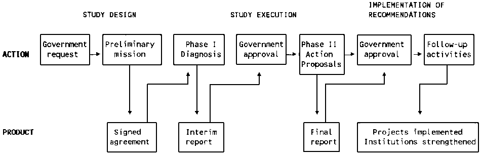
While the process is more or less standardized, each agency develops its own version. The development planning process evolved by the OAS Department of Regional Development consists of four stages: Preliminary Mission, Phase I (development diagnosis), Phase II (project formulation and preparation of an action plan), and implementation. Because the process is cyclical, activities relating to more than one stage can take place at the same time. The main elements of the process are shown in Figure 4, and a synthesis of the activities and products of each stage is shown in Figure 5. A comprehensive set of guidelines for executing a study following this process is given in Regional Development Planning: Guidelines and Case Studies from OAS Experience.
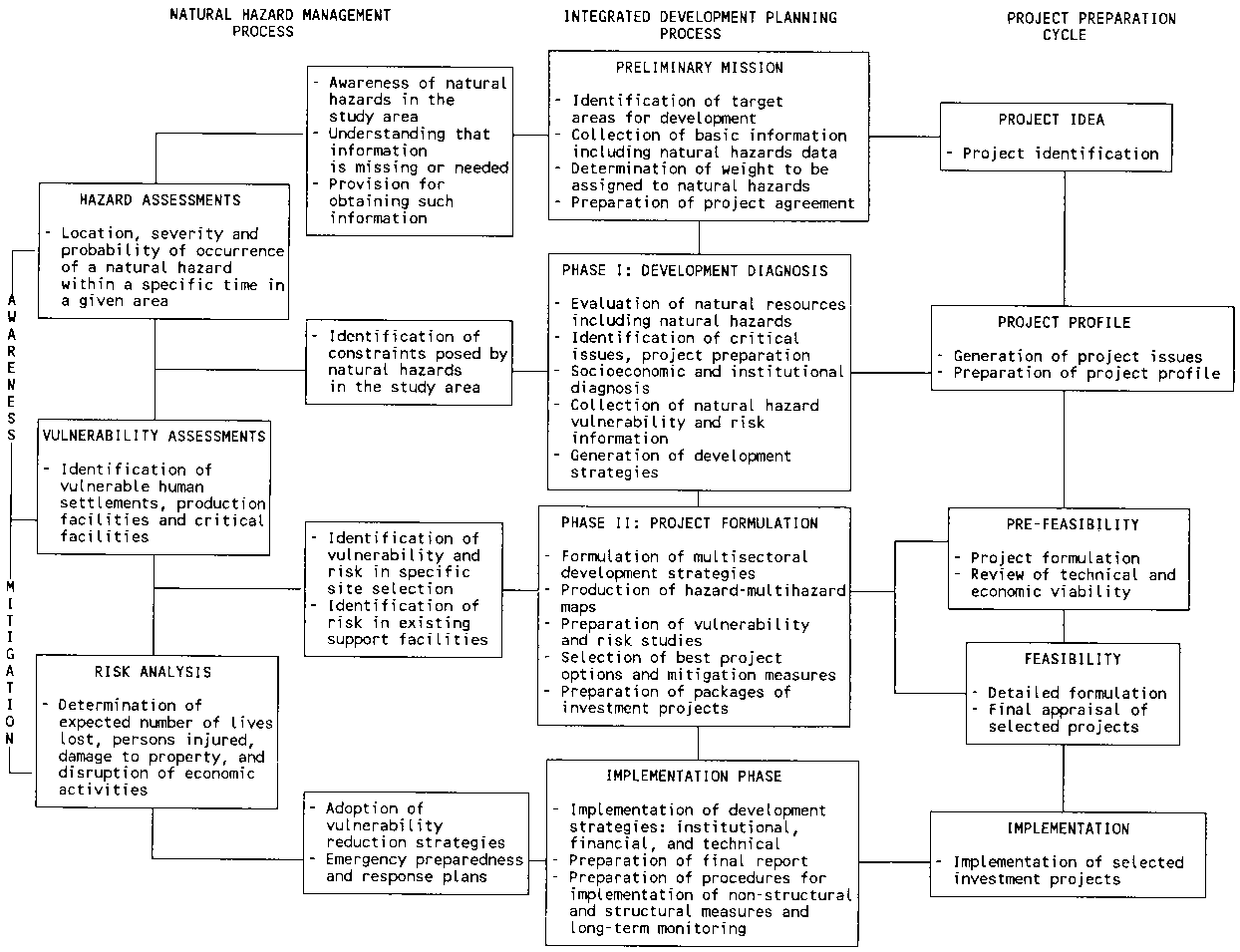
This presentation of the procedures of an integrated study features the incorporation of hazard management considerations at each stage. The relationships of the integrated development planning process, the hazard management process, and the project cycle are summarized in Figure 6.
Generally, planners depend on the science and engineering community to provide the required information for natural hazard assessments. If the information available is adequate, the planner may decide to make an assessment. If it is not adequate, the planner usually decides that the time and cost of generating more would be excessive, and the assessment is not made. While the information available on hurricanes and geologic hazards is often adequate for a preliminary evaluation, the information on desertification, flooding, and landslide hazards rarely is. The OAS has developed fast, low-cost methodologies that make these evaluations possible in the context of a development study. The differences in treating the various hazards in each stage of the process are highlighted in the following discussion.
Preliminary Mission: Designing the Study
The first step in the process of technical assistance for an integrated development planning study is to send a "preliminary mission" to consult with officials in the interested country. Experience has shown that this joint effort of OAS staff and local planners and decision-makers is frequently the most critical event in the entire study. They take action to:
- Determine whether the study area is affected by one or more natural hazards. For example, the National Environmental Study of Uruguay conducted by the OAS with financial support from the Inter-American Development Bank determined in the preliminary mission that natural hazards were an important environmental problem, and consequently an assessment of all significant hazards, to be conducted by reviewing existing information, was programmed for Phase I.- Identify the information available for judging the threat posed by those hazards in the study area: history of hazardous events; disaster and damage reports; assessments of hazards, vulnerability, risk; maps and reports on natural resources and hazards; topographic maps, aerial photographs, satellite imagery.
- Determine whether the available data are sufficient to evaluate the threat of hazards. If they are not, determine what additional data collection, hazard assessment, remote sensing, or specialized equipment will be needed for the next stage of the study. For example, in preliminary missions in Dominica, Saint Lucia, and St. Vincent and the Grenadines, landslides were determined to be a serious problem, and landslide assessments were included in the work plan for Phase I.
- Determine whether the studies required would serve more than one sector or project. If so, establish coordination.
- Establish coordination with the national institution responsible for disaster planning.
- Prepare an integrated work plan for Phase I that specifies the hazard work to be done, the expertise needed, and the time and cost requirements.
Source: OAS. Integrated Regional Development Planning: Guidelines and Case Studies from OAS Experience. (Washington, D.C.: OAS, 1984).
Phase I: Development Diagnosis
In Phase I, the team analyzes the study region and arrives at detailed estimates of development potentials and problems of the region and selected target areas. From this analysis a multisectoral development strategy and a set of project profiles are prepared for review by government decision-makers. Phase I also includes a detailed assessment of natural hazards and the elements at risk in highly vulnerable areas which facilitates the early introduction of non-structural mitigation measures. During this phase the team will:
- Prepare a base map.- Determine the goods, services, and hazards of the region's ecosystems. Identify cause-and-effect relationships between natural events and between natural events and human activity. In the hilly Chixoy region of Guatemala, for example, it was found that inappropriate road construction methods were causing landslides and that landslides, in turn, were the main problem of road maintenance. In Ecuador, the discovery that most of the infrastructure planned for the Manabí Water Development Project was located in one of the country's most active earthquake zones prompted a major reorientation of the project.
- Evaluate socioeconomic conditions and institutional capacity. Determine the important linkages between the study region and neighboring regions.
- Delineate target areas of high development potential, followed by more detailed natural resource and socioeconomic studies of these areas.
- In planning the development of multinational river basins or border areas where a natural disaster could precipitate an international dispute, make an overall hazard assessment as part of the resource evaluation. Examples of such studies include those for the development of the San Miguel-Putumayo River Basin, conducted in support of the Colombia-Ecuador Joint Commission of the Amazon Cooperation Project, and for the Dominican Republic and Haiti Frontier Development Projects.
- Conduct assessments of natural hazards determined to be a significant threat in the study region. For hurricanes and geologic hazards, the existing information will probably suffice; if the information on geologic hazards is inadequate, an outside agency should be asked to conduct an analysis. For flooding, landslides, and desertification, the planning team itself should be able to supplement the existing information and prepare analyses. The studies of the Honduran departments of Atlántida and Islas de la Bahía included flood hazard assessment as part of the coastal area development plan and landslide hazard assessments for some of the inland areas.
- Conduct vulnerability studies for specific hazards and economic sectors. Prepare lifeline maps, hazard zoning studies, and multiple hazard maps as required. The study of the vulnerability of the Ecuadorian agriculture sector to natural hazards and of ways to reduce the vulnerability of lifelines in St. Kitts and Nevis, for example, both generated project ideas which could be studied at the prefeasibility level in Phase II. The study of the Paraguayan Chaco included flood and desertification assessments and multiple-hazard zoning. The execution of these hazard-related activities did not distort the time or cost of the development diagnosis.
- Identify hazard-prone areas where intensive use should be avoided.
- Prepare a development strategy, including non-structural mitigation measures as appropriate.
- Identify project ideas and prepare project profiles that address the problems and opportunities and that are compatible with political, economic, and institutional constraints and with the resources and time frame of the study.
- Identify structural mitigation measures that should be incorporated into existing facilities and proposed projects.
- Prepare an integrated work plan for the next stage that includes hazard considerations.
Figure 5 - SYNTHESIS OF THE OAS INTEGRATED DEVELOPMENT PLANNING PROCESS
|
COMPONENTS |
STUDY DESIGN |
STUDY EXECUTION |
IMPLEMENTATION OF THE RECOMMENDATIONS |
|
|
PHASE I |
PHASE II |
|||
|
Development Diagnosis |
Project Formulation and Preparation of Action Plan |
|||
|
Activities:
|
Receipt and analysis of request for cooperation |
Diagnosis of the region |
Project formulation (pre-feasibility or feasibility) and evaluation |
Assistance for specific programs and projects |
|
Preliminary Mission |
- sectoral analysis |
- production sectors (agriculture, forestry, agroindustry, industry, fishing, mining) |
Assistance in incorporating proposed investments into the national budget |
|
|
- pre-diagnosis |
- spatial analysis |
- support services (marketing, credit, extension) |
Advisory services for private sector actions |
|
|
- cooperation agreement preparation
|
- institutional analysis |
- social development (housing, education, labor training, health) |
Support to executing agencies |
|
|
- environmental analysis |
- infrastructure (energy, transportation, communications) |
Support in the inter-institutional coordination |
||
|
- synthesis: needs, problems, potentials, constraints |
- urban services |
|
||
|
Relation to national plans, strategies and priorities |
- natural resource management |
|
||
|
Development strategies |
Action plan preparation |
|
||
|
- formulation and analysis of alternatives |
- formulation of project packages |
|
||
|
- identification of project ideas, preparation of project profiles
|
- determination of policies for priority areas and sectors |
|
||
|
- enabling and incentive actions |
|
|||
|
- investment timetable |
|
|||
|
- evaluation of funding sources |
|
|||
|
- institutional development and training |
|
|||
|
- promotion |
|
|||
|
Products:
|
Signed agreement |
Interim Report (Phase I) |
Final Report |
Execution by government of |
|
- definition of the study products |
- diagnosis of the region |
- development strategy |
- final design studies |
|
|
- financial commitments of participants |
- preliminary development strategy |
- action plan |
- project implementation |
|
|
- preliminary workplan
|
- identified projects
|
- formulated projects |
- changes in legislation and regulations |
|
|
- supporting actions |
|
|||
|
|
Improved operational capability of institutions |
|||
|
Time Frame: |
3 to 6 months |
9 to 12 months |
12 to 18 months |
Variable |
Source: OAS. Primer on Natural Hazard Management in Integrated Development Planning. (Washington, D.C.: In Press)
Figure 6 - INTEGRATED DEVELOPMENT PLANNING PROCESS, NATURAL HAZARD MANAGEMENT, AND THE PROJECT CYCLE
Source: OAS. Primer on Natural Hazard Management in Integrated Development Planning (Washington, D.C.: In Press).
Phase II: Project Formulation and Action Plan Preparation
At the end of Phase I a development strategy and a set of project profiles are submitted to the government. Phase II begins after the government decides which projects merit further study. The team now makes prefeasibility and feasibility analyses of the projects selected. Refined estimates are made of benefits (income stream, increases in production, generation of employment, etc.) and costs (construction, operation and maintenance, depletion of resources, pollution effects, etc.). Valuative criteria are applied, including net present value, internal rate of return, cost-benefit ratio, and repayment possibilities. Finally, the team assembles packages of investment projects for priority areas and prepares an action plan. More detail on this phase is given in the section on Hazard Mitigation Strategies for Development Projects, but broadly speaking the team must:
- Examine the human activities that could contribute to natural hazards (e.g., irrigation, plowing in the dry season, and animal husbandry could cause or exacerbate desertification) and the social and cultural factors that could influence project vulnerability during and after implementation.- Determine the levels of technology, credit, knowledge, information, marketing, etc., that it is realistic to expect will be available to the users of the land, and ensure that the projects formulated are based on these levels.
- Prepare site-specific vulnerability and risk assessments and appropriate vulnerability reduction measures for all projects being formulated. For example, the multimillion-dollar program for the development of the metropolitan area of Tegucigalpa, Honduras, featured landslide mitigation components. Flood alert and control projects were central elements in the comprehensive Water Resource Management and Flood Disaster Reconstruction Project for Alagoas, Brazil.
- Mitigate the undesirable effects of the projects, avoid development in susceptible areas, recommend adjustments to existing land use and restrictions for future land use.
- Examine carefully the compatibility of all projects and proposals.
- Define the specific instruments of policy and management required for the implementation of the overall strategy and the individual projects; design appropriate monitoring programs.
Implementing the Study Recommendations
The fourth stage of the development planning process helps implement the proposals by preparing the institutional, financial, and technical mechanisms necessary for successful execution and operation. Efforts made to consider hazards in previous stages will be lost unless mitigation measures are closely adhered to during the projects' execution. Either the planning agency or the implementing agency should:
- Ensure that suitable hazard management mechanisms have been included in all investment projects; provide for monitoring of construction to ensure compliance with regulations, and for ongoing monitoring to ensure long-term compliance with project design.- Ensure that national disaster management organizations have access to the information generated by the study. Point out hazardous situations for which the study did not propose vulnerability reduction measures.
- Arrange for the continuing collection of hazard data and the updating of information of planning and emergency preparedness agencies.
- Prepare legislation mandating zoning codes and restrictions, building and grading regulations, and any other legal mechanisms required.
- Include adequate financing for hazard mitigation measures.
- Involve the private sector in the vulnerability reduction program.
- For community-based vulnerability reduction programs, establish national training and hazard awareness programs for town and village residents, a feature of OAS technical assistance programs for Saint Lucia and Grenada.
- Generate broad-based political support through the media, training programs, and contacts with community organizations. Use products of the studies (photos, maps, charts, etc.) for mass communication. Use personnel who participated in the studies in public meetings to promote the concept of vulnerability reduction.
- Accelerate the implementation of projects that include hazard mitigation considerations; if budget cutbacks occur, reduce the number of projects rather than dropping the hazard mitigation components.
Even though integrated development planning and hazard management are usually treated in Latin America and the Caribbean as parallel processes that intermix little with each other, it is clear that they should be able to operate more effectively in coordination, since their goals are the same-the protection of investment and improved human well-being-and they deal with similar units of space. Some of the advantages of such coordination are the following:
- There is a greater possibility that vulnerability reduction measures will be implemented if they are a part of development package. The possibility increases if they are part of specific development projects rather than stand-alone disaster mitigation proposals. Furthermore, including vulnerability reduction components in a development project can improve the cost-benefit of the overall project if risk considerations are included in the evaluation. A dramatic example is the case study on vulnerability reduction for the energy sector in Costa Rica.- Joint activities will result in a more efficient generation and use of data. For example, geographic information systems created for hazard management purposes can serve more general planning needs.
- The cost of vulnerability reduction is less when it is a feature of the original project formulation than when it is incorporated later as a modification of the project or an "add-on" in response to a "hazard impact analysis." It is even more costly when it is treated as a separate "hazard project," independent of the original development project, because of the duplication in personnel, information, and equipment.
- Exchanging information between planning and emergency preparedness agencies strengthens the work of the former and alerts the latter to elements whose vulnerability will not be reduced by the proposed development activities. In the Jamaica study of the vulnerability of the tourism sector to natural hazards, for example, solutions were proposed for most of the problems identified, but no economically viable solutions were found for others. The industry and the national emergency preparedness agency were so warned.
- With its comprehensive view of data needs and availability, the planning community can help set the research agenda of the science and engineering community. For example, when a planning team determines that a volcano with short-term periodicity located close to a population center is not being monitored, it can recommend a change in the priorities of the agency responsible.
- Incorporating vulnerability reduction into development projects builds in resiliency for the segment of the population least able to demand vulnerability reduction as an independent activity. A clear example of this situation was the landslide mitigation components of the metropolitan Tegucigalpa study: the principal beneficiaries were the thousands of the city's poor living in the most hazard-prone areas.
![]()
![]()
![]()
![]()