![]()
![]()
![]()
![]()
The United Nations declared the 1990s the International Decade for Natural Disaster Reduction. The 1990s is also a time when for many developing countries coping with disasters is becoming virtually synonymous with development: the cost of rehabilitation and reconstruction in the wake of disasters is consuming available capital, significantly reducing the resources for new investment.
The toll is appalling. Since 1960 earthquakes, hurricanes, floods, droughts, desertification, and landslides in the Latin American and Caribbean region have killed 180,000 people, disrupted the lives of 100 million more, and caused more than US$54 billion in property damage. Rates of destruction increase decade after decade. The adverse effects on employment, balance of trade, and foreign indebtedness continue to be felt years after the occurrence of a disaster. Activities intended to further development often exacerbate the impact of natural hazards. Worst of all, the poorest countries and the poorest segments of their populations feel the severest impact. International relief and rehabilitation compensates the stricken countries for only a small part of their losses.
The good news is that, of all the global environmental problems, natural hazards present the most manageable of situations: the risks are most readily identified; effective mitigation measures are available; and the benefits of vulnerability reduction may greatly outweigh the costs. Moreover, experience shows that the impact of natural hazards can be reduced. Improved warning and evacuation systems have cut the death toll of hurricanes dramatically. Combinations of structural and non-structural mitigation measures have been shown to alleviate the effects of earthquakes, landslides, floods, and droughts.
Yet the countries of the region are slow to undertake actions of vulnerability reduction or to request financing for them, development financing and donor agencies are reluctant to finance them, and most development cooperation agencies provide little service in this subject area. Despite the cost-effectiveness of mitigation measures, more than 90 percent of international funding for natural hazard management in the region is spent on disaster preparedness, relief, rehabilitation, and reconstruction, leaving less than 10 percent for prevention before a disaster.
There are reasons for this seemingly anomalous situation. More important, actions can be taken to change it. This book, a synthesis of the natural hazard experience of the Department of Regional Development and Environment of the Organization of American States (OAS/DRDE), argues that the most effective approach to reducing the long-term impact of natural hazards is to incorporate natural hazard assessment and mitigation activities into the process of integrated development planning and investment project formulation and implementation.
The book is directed toward decision-makers in the member states and in development assistance agencies with the hope of influencing them:
- to incorporate natural hazard considerations early in the process of integrated development planning and investment project formulation.- to put a higher value on risk reduction in evaluating investment projects.
- to increase the proportion of expenditures for prevention activities relative to rehabilitation and reconstruction.
Guidelines for incorporating natural hazard considerations into development planning and project formulation can be summarized as follows:
HAZARD MITIGATION STRATEGIES FOR DEVELOPMENT PLANNING
Natural hazard management is often conducted independently of integrated development planning. It is important to combine the two processes. Of the many components of hazard management, the following techniques are the most compatible with the planning process:
- Natural hazard assessment: an evaluation of the location, severity, and probable occurrence of a hazardous event in a given time period.- Vulnerability assessment: an estimate of the degree of loss or damage that could result from a hazardous event of given severity, including damage to structures, personal injuries, and interruption of economic activities and the normal functions of settlements.
- Risk assessment: an estimate of the probability of expected loss for a given hazardous event.
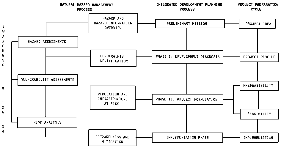
Integrated development planning is a multidisciplinary, multisectoral process that includes the establishment of development policies and strategies, the identification of investment project ideas, the preparation of projects, and final project approval, financing, and implementation. The OAS/DRDE version of this project cycle consists of four stages: Preliminary Mission, Phase I (development diagnosis), Phase II (project formulation and preparation of an action plan), and Project Implementation. The development planning and hazard management activities in each of these stages are summarized in the diagram on the next page.
The advantages of incorporating hazard management into development planning include the following:
- Vulnerability reduction measures are more likely to be implemented as part of development projects than as stand-alone mitigation proposals.- The cost of vulnerability reduction is less when the measure is a feature of the original project formulation than when it is incorporated later.
- The planning community can help set the science and engineering research agenda to focus more on the generation of data suitable for immediate use in hazard mitigation.
- Building vulnerability reduction into development projects benefits the poorest segments of the population.
HAZARD MITIGATION STRATEGIES FOR PROJECT FORMULATION
Examples of structural measures that can mitigate the effects of natural hazard events include building codes and materials specifications, retrofitting of existing structures to make them more hazard-resistant, and protective devices such as dikes. Non-structural measures concentrate on identifying hazard-prone areas and limiting their use. Examples include land-use zoning, tax incentives, insurance programs, and the relocation of residents away from the path of a hazard. A strong case can be made for emphasizing non-structural mitigation in developing countries, since structural mitigation measures have a direct cost that must be added to the costs of a project. Non-structural measures may have some capital and/or operating costs but these are usually less than structural costs.
Several questions enter into the issue of risk vis-a-vis investment projects:
Should risk be considered in the evaluation of investment projects?
Governments may argue that they should be indifferent between high-risk and low-risk public sector projects that have the same expected net present value because the risks, being widely shared throughout the society, are negligible to each individual. But this ignores governments' obligation to consider the opportunity cost of each investment. International financing agencies can be indifferent to risk because the country will be obligated to repay the loan whether or not the structure is destroyed by an earthquake. But this ignores the agencies' efforts to inculcate fiscal responsibility. Economic arguments notwithstanding, it simply makes common sense to include natural hazard risk in project evaluation just as the risk of market loss is considered.
How should competing project objectives be evaluated? This question should be addressed even before the search for project ideas begins. One approach to incorporating societal goals and priorities into the selection of projects is multicriteria analysis. This involves convening a meeting of a cross-section of a society's interest groups to array important social and economic objectives and agree on discriminatory weights for each. Projects can then be evaluated in terms of their capacity to fulfill the stated goals. Reducing vulnerability to natural hazards can be established as one of the goals.
How can the conflicting demands of different interest groups for the use of the same natural good or service be resolved? This is the classic problem that often goes under the misnomer "environmental impact." A feature of good planning is the identification of potential competition over the use of natural goods and services and seeking resolutions to these conflicts that are reasonably satisfying to all parties.
What are objective measures for evaluating natural hazard risk as an element of overall investment project evaluation? Two kinds of methods are available: those based on the availability of limited information and those based on probabilistic information. Several techniques in each category are described and the conditions under which each is applicable are noted.
INTEGRATED DEVELOPMENT PLANNING PROCESS, NATURAL HAZARD MANAGEMENT, AND THE PROJECT CYCLE
Source: OAS. Primer on Natural Hazard Management in Integrated Development Planning (Washington, D.C.: In Press)
STRATEGIES FOR SPECIFIC HAZARDS
How do planners incorporate natural hazards into an integrated study for the development of an area? First, they must determine which hazards, if any, pose a serious threat. Next, they must prepare an assessment of any threatening hazards. Up to now planners have relied largely on existing information because conducting hazard assessments was too costly and time-consuming to fit comfortably into a development planning study. Using techniques developed by the OAS, it is now possible to conduct assessments and introduce hazard mitigation measures in the context of a development study.
Hurricanes
Hurricanes occur in well-defined belts in the Caribbean and on the west coast of Central America. If a study area lies within these belts, the planner can proceed to determine risks and seek mitigation measures. Since storm surge (a rise in sea level due to the low barometric pressure of the storm) is by far the most damaging hurricane hazard, lowland areas close to the sea are the most jeopardized. Storm monitoring and improved warning and evacuation measures are the most effective mechanisms for saving lives. Some low-cost structural mitigation measures can reduce damage (e.g., ensuring that roofs are tied down, covering large glass panels, and removing projections that can easily be blown off). Small towns and villages must depend largely on their own resources to defend against hurricanes.
This requires preparing community leaders and establishing a national program for training and maintaining communication with local personnel.
Desertification
This human-induced hazard is defined as the creation or spread of desert-like conditions beyond desert margins. Desertification occurs in narrowly circumscribed arid or semiarid areas; the text classifies the status of desertification for political subdivisions of South America and Mexico. Development actions that could cause or exacerbate desertification in these areas should be avoided. If a study area is located in one of the areas listed as having desertification potential, a hazard assessment can be prepared quickly using four widely available parameters: precipitation, soil texture, slope, and the ratio of precipitation to evapotranspiration. The technique defines 16 mappable units, each with a set of characteristics that indicate preferred management practices. Once the potential problems are pinpointed, mitigation and rehabilitation measures for animal husbandry, dry-land agriculture, soil erosion, and salinization can be applied.
Geologic hazards
Enough scientific information exists to determine whether earthquakes, volcanic eruptions, or tsunamis constitute a significant threat in virtually any area of Latin America and the Caribbean. It was not readily accessible up to now, but this document assembles the information and puts it into a form suitable for use in planning. Areas that have a high probability of a large earthquake in the next 20 years are listed by political subdivision. All volcanoes that have erupted in Latin America and the Caribbean in the last 10,000 years are categorized as having long-or short-term eruption intervals: any study area within 30 km of a volcano having short-term periodicity must be considered as being under threat of an eruption. Large tsunamis strike only on the west coast of Latin America, and so rarely that mitigation measures can be economically justified only for large urban concentrations. A list of all cities so threatened shows the maximum likely height of a tsunami.
Floods
The existing information is rarely sufficient for evaluating flood potential in a study area, but using remote sensing interpretation, a flood hazard assessment can be prepared that fits the time and budgetary constraints of a development planning study. Such an assessment is useful for designing both new projects and mitigation measures for existing development threatened by floods.
Landslides
As with flooding, the existing information is rarely sufficient for evaluating landslide potential in a study area, but new techniques make rapid analysis of the potential possible. Past landslides can be located on aerial photographs or satellite imagery, and a landslide zonation map can be compiled showing the relationship of landslides to causative factors-bedrock, slope, and moisture conditions.
STRATEGIES FOR SELECTED ECONOMIC SECTORS
Economic sectors such as energy, tourism, agriculture, and transport can benefit from an analysis to determine their vulnerability to natural hazards. Conclusions synthesized from sector vulnerability studies to date include the following:
- Vulnerability reduction measures can be cost-effective, either as stand-alone projects or, more commonly, as components of overall sector development programs.- Sectoral studies reveal previously unrecognized linkages between disasters and development.
- A sector may have to select between competing objectives to arrive at an acceptable vulnerability reduction strategy.
TOOLS AND TECHNIQUES FOR NATURAL HAZARD ASSESSMENTS
Geographic Information Systems (GIS)
A GIS, a systematic means of geographically referencing information about a unit of space, can facilitate the storage, retrieval, and analysis of data in both map form and tables. It can be a manual system, but most GIS are computerized, as dictated by the overwhelming number of pieces of information needed for natural hazard management, particularly in the context of development planning. A GIS can be surprisingly inexpensive; it can multiply the productivity of a technician; its use can give higher quality results than can be obtained manually regardless of the costs.
Remote Sensing in Natural Hazard Assessments
Remote sensing refers to the process of recording information from sensors mounted either on aircraft or on satellites. These techniques can be used to reveal the location of past occurrences of natural events and/or to identify the conditions under which they are likely to occur, so that areas of potential exposure can be distinguished and applicable mitigation measures can be introduced into the planning process.
The kinds of aerial and satellite remote sensing techniques available for the preparation of natural hazard assessments and the applicability of each to the various stages of a development study are explained.
Special Mapping Techniques
Multiple-hazard maps combine assessments of two or more natural hazards on a single map. Such a product is excellent for analyzing vulnerability and risk since the combined effects of natural phenomena on an area can be determined and mitigation techniques suitable for all can be identified. Critical facilities-transport and communication facilities, utilities, large auditoriums, hospitals, police and fire stations, etc.-must also be mapped as a part of the process of emergency planning. Combining critical facilities mapping with multiple hazard mapping provides information to guide the identification of projects and mitigation measures.
STRATEGIES FOR DEVELOPMENT ASSISTANCE AGENCIES
Activities that technical cooperation agencies can undertake to promote natural hazard assessment and mitigation include:
- Strengthening planning institutions' ability to incorporate natural hazard considerations into the planning process.- Supporting pilot projects of natural hazard assessments.
- During relief and reconstruction efforts in the aftermath of a disaster, stimulating the interest of the government and development assistance agencies in natural hazard assessment and mitigation.
- Building natural hazard assessments into sector planning.
- Including in the preparation and evaluation of investment projects the costs and benefits of incurring vs. avoiding the impacts of natural hazards.
- Preparing case studies of noteworthy experiences that show how funding activities can be made more responsive to natural hazards.
A strategy to promote lending and donor agency interest in hazard assessment and mitigation consists of three elements:
- Change the context in which the lenders and donors perceive governments and technical cooperation agencies to be addressing natural hazard issues. Recipient countries can show their capacity to deal with natural hazards by focusing on priority hazards and sectors; by choosing simple, practical information collection and analysis systems; and by demonstrating a commitment to implementing study findings. Technical cooperation agencies can make study outputs appeal to lenders and donors by seeking practical and cost-effective solutions to recurrent problems and can identify mechanisms of cooperation with financing agencies such as pooling technical resources, exchanging experiences, and joint staff training in natural hazard issues.- Establish incentives for analysis. Development financing agencies will be more willing to incorporate natural hazard considerations into project preparation and evaluation if minimum change in existing procedures is required. Ways to promote this include providing reusable information, integrating hazard concerns into existing review mechanisms, promoting proven mitigation measures in relation to specific types of projects, incorporating appropriate costs and benefits of hazard mitigation into economic appraisal, and sensitizing staff members.
- Assign accountability for losses. Bank directors and staff should be made more aware that projects they help plan or fund may suffer losses from natural disasters. Losses from natural disasters should be evaluated in the context of the lender's program area and its project design and repayment performance. The inclusion of techniques to deal with natural hazards in the professional standards of bank staff should be promoted.
![]()
![]()
![]()
![]()