![]()
![]()
![]()
![]()
![]()
I. Introduction
II. Designing the study
III. Executing the study
IV. Implementing the recommendations
V. Epilog: Four years later
VI. Lessons learned
VII. Bibliography
![]()
PROBLEM SUMMARY
Opening a Remote Tropical Region With a Penetration Road-Planning Integrated Development in the Darien Region (Panama)
The Panama-Darien study (1974-77) was aimed at finding ways to support development and preserve the resource base in a tropical forest region that a new segment of the Pan American Highway would open to settlers. Additional objectives were to create local employment opportunities and to integrate the regional economy with the national economy. DRD's tasks were to propose coordinated and mutually reinforcing development projects for the short- and medium-terms.
The investments recommended for the 16,800 km2 area totalled US$49,000,000. Based on a natural resource assessment and the identification of two high-priority development zones, the planning team made "pre-feasibility" proposals for integrated agricultural, livestock, forestry, fishery, agro-industrial, energy, roads, communications, and social service programs in the most promising settlement areas. Together, these programs would generate an estimated 3,400 direct jobs in a population predicted to jump from 24,400 to 34,400 with the completion of the road.
PANAMA - DARIEN REGION STUDY - Fact Sheet
|
Project area: |
16,803 km2 | |||
|
Population: |
24,400 | |||
|
Physical characteristics: | ||||
|
|
- Holdridge life zones: | |||
|
|
|
Tropical Moist Forest | ||
|
|
|
Premontane Very Moist Forest | ||
|
|
|
Low Montane Rain Forest | ||
|
|
|
Premontane Rain Forest | ||
|
|
- Elevation range: Sea level to 1,800 m | |||
|
|
- Land capability classification: | |||
|
|
|
Classes II-V: 9.1% | ||
|
|
|
Classes VI-VIII: 90.9% | ||
|
Duration of Project: | ||||
|
|
Preliminary Mission: 1973 | |||
|
|
Preparatory Mission: 1974 | |||
|
|
Fieldwork: 2/1975-7/1978 | |||
|
|
Publication of Final Report: 1978 | |||
|
Technical contributions: | ||||
|
DRD disciplines (23) |
Number of DRD/Experts (42) | |||
|
Agricultural Engineer (Project Chief) |
1 | |||
|
Project Deputy Chief (Specialist in Project Formulation, later Project Chief) |
1 | |||
|
Agricultural Economist |
1 | |||
|
Agricultural Production Specialist |
3 | |||
|
Agro-industries Specialist |
2 | |||
|
Anthropologist |
1 | |||
|
Cartographer |
2 | |||
|
Communications Specialist |
1 | |||
|
Cooperatives Development Specialist |
1 | |||
|
Economist |
1 | |||
|
Editor |
1 | |||
|
Environmental Specialist |
6 | |||
|
Fisheries Specialist |
1 | |||
|
Forest Industries Specialist |
2 | |||
|
Geologist |
1 | |||
|
Health Specialist |
2 | |||
|
Institutional Development Specialist |
1 | |||
|
Municipal Development Specialist |
1 | |||
|
Project Implementation Specialist |
1 | |||
|
Regional Economist |
3 | |||
|
Regional Planner |
3 | |||
|
Rural Electrification Specialist |
1 | |||
|
Soils Engineer |
2 | |||
|
Transportation Specialist |
1 | |||
|
Water Resources Planner |
2 | |||
|
Total professional person-months: | ||||
|
|
DRD: 176 Government of Panama: 122 | |||
|
Financial contribution: | ||||
|
|
DRD: US$473,500 Government of Panama: US$268,000 | |||
|
Total investment in projects proposed: US$49,000,000 | ||||
Opening new resource-rich areas is an important part of development for countries still favored with such untapped potential. But developing nearly empty areas is a mixed blessing. A penetration road can create new social, economic, and cultural opportunities. If new roads connect one country with another, trade benefits can be substantial. But as access to remote regions increases, so do the ill effects of spontaneous colonization - deforestation, erosion, the depletion of other natural resources, pressures on limited social services, and the spread of disease.
This account of planning the development of the Darien region of Panama, through which the Pan American Highway was to be built, illustrates both the great difficulty of limiting spontaneous colonization along a penetration road through a remote humid tropical forest and the commensurate importance of integrated development planning. (The location of the Darien region is shown on Map 1.)
Key methodological challenges highlighted in the case study include:
· Focussing the study of a large region on small areas of concentration;· Preparing "packages" of complementary projects for settlements in a nearly empty area;
· Attempting to keep these packages from unravelling as available investment financing decreases;
· Minimizing damage due to spontaneous colonization along a major penetration road; and
· Integrating development planning activities on both sides of an international border.
The Darien Gap region typifies the potential and problems of many tropical forest regions in Latin America. Loggers have removed most of the cedar, mahogany, and other valuable wood, and the small-scale farmers who have settled the area in their wake have planted corn and bananas on the easily exhausted soils that lie beneath the forest cover.
The sparsely populated Darien region is inhabited by isolated ethnic groups, each with its own laws and customs. Per capita income is low and social services minimal. To address such problems, Panama's 1972 constitution created a new institutional framework for spurring economic development, raising living standards, and increasing citizen participation in the provinces.
At the national level, Panama has suffered from the worldwide inflation and subsequent recession set off by the oil crisis in 1973. The country's current development goals are to increase reliance on indigenous energy sources, raise agricultural productivity in the traditional food-producing provinces, and improve public works and services, especially in the interior. The national government has also promoted Panama as an international financial and tourist center.
During the 1970s, Panama renegotiated Canal treaties with the United States, extending Panama's sovereignty over territories once under U.S. control. During these negotiations, however, the private sector adopted a "watch and wait" position and its share of total investment fell, which contributed to economic stagnation.
Against this backdrop, the Darien region study was initiated to assess the potential, of using the Pan American Highway to further eastern Panama's development without undercutting the productive resource base. Since spontaneous development would inevitably occur when the Darien became accessible, Panama asked the Organization of American States (OAS) to help it plan development activities with minimal negative impacts.
The Darien study demonstrates the process of narrowing down a large study area to selected smaller areas by
· Dividing the study area into subregions or programming zones and selecting the most promising programming zones;· Delineating the best settlement areas within the selected programming zones; and
· Identifying specific projects within the settlement areas.
This rapid contraction of the study area paid off: by sharpening the focus of investigation, the planning team realized concrete results with minimum expenditures of time and resources.
The study also describes the process of revising study recommendations as investment capital commitments drop without sacrificing the integrity of the projects recommended - in this case, keeping the packages intact. The sequence was, first, recommending the development of eight settlement areas, then concentrating on only two of the eight, and, finally, phasing project implementation in the two.
The study also illustrates the futility of both prescriptive and "add-on" approaches to environmental management. The Panamanian Government's efforts to legally restrict spontaneous colonization adjacent to the new penetration road failed, and none of the so-called environmental projects has been implemented. In contrast, the study team recommended developing selected areas rapidly and intensively to provide jobs and services for migrants and thus reduce spontaneous colonization in the less productive areas. These proposals were aimed at systematizing both the analysis and development of the area.
A. The Preliminary Mission
Responding to the Panamanian Government's request for technical assistance, the Department of Regional Development (DRD) of the OAS sent a preliminary mission to Panama for four weeks in 1973. The team was composed of a senior DRD headquarters official (a geographer), an economist, a water resources specialist, and a transportation engineer. The mission's goals were to analyze the impact of the development strategy the national government had adopted for the region, inventory and evaluate existing projects in the Darien Gap, and generate ideas for additional actions.
These activities were designed to lay the groundwork for multidisciplinary studies incorporating physical, socio-economic, legal, political, and institutional analyses. Panama favored this integrated approach to regional development, which conformed with its national development strategy for the 1970s, its decision to develop the Darien region, and its new interdepartmental commission for developing the region.
The mission discussed two major projects with Panamanian officials: the construction of the Bayano Dam for generating hydroelectricity and the completion of the Pan American Highway to the Colombian border. The government had already launched a development planning project for the Bayano and enacted a law (N°71) making the Pan American Highway a high national priority and restricting settlement to an eight-kilometer strip on both sides of the highway. The road and the dam, both under the jurisdiction of the Ministry of Agriculture, represented large capital outlays and the extension of new services to remote areas. Both also posed the threat of natural resource degradation.
Panamanian officials wanted the road to integrate the Darien with the rest of the country and to connect Panama to Colombia and points south. Thus, the mission proposed six broad goals for the Darien study: (1) accelerating the region's contribution to the country's economic development, (2) raising the employment level in the Darien, (3) increasing the farm sector's income, (4) increasing agricultural and agro-industrial production, (5) protecting and gradually integrating local indigenous groups, and (6) preserving and managing regional ecosystems, To realize these broad goals, the mission proposed preliminary targets for guiding rural immigration, improving forestry management and development, bringing social services in Darien up to the national average, developing population centers, and raising regional per capita income.
Within a month's time, the mission had examined the region's problems, current and planned activities, and development opportunities. Taking local and national perceptions of the Darien's development into account, the mission presented proposals as hypotheses that could be confirmed or rejected with a minimum of additional study - an approach that held costs down by eliminating unproductive lines of investigation,
Before the study could be formally initiated, the physical boundaries of the study area, the contributions the OAS and the Government of Panama would make to the study, and the level of investment capital Panama would dedicate to implementing the study team's recommendations had to be determined. So as to include both the Highway and Bayano projects, the province of Darien and the Chepo and Chiman districts of Panama province were included in the study area. Since it quickly became clear that study resources were not sufficient to achieve the results the Panamanian Government desired, the scope of work had to be curtailed to match the available resources. While Panama deferred decisions on project-implementation funding, the team took three steps to stay within the planning budget:
- Limiting the time frame of the study by concentrating on development up to the year 1985. (Later, as investment funds became still more limited, the focus was further narrowed to a five-year action program.)- Formulating investment projects through the pre-feasibility level only.
- Restricting the geographic focus. The highest priority subregions would be quickly delimited, and subsequent work would be concentrated in these areas.
B. Designing the Management Structure
Soon after the preliminary mission took place, a new Planning and Economic Policy Department was created within Panama's Ministry of Planning and Economic Policy (MIPPE) to coordinate the development activities of other departments and decentralized agencies. Although the Ministry of Agriculture had expressed interest in sponsoring the study team, MIPPE became the counterpart agency because it could make the project a high national priority, its office of Regional Planning and Coordination shared most of the Darien study team's views of regional planning, it designated the provincial planners, and it had budget authority for implementing projects.
The study was to have two management tiers: an executive commission and a technical unit. (See Figure 1.) MIPPE's Minister would preside over the executive commission, which would also include DRD's director and the Ministers of Agriculture and Public Works. Technical unit staff - the study team's national director, MIPPE staff, and the head of the international mission-would work with national and international specialists to conduct the studies the executive commission ordered. By involving national and international personnel in each task, this management structure would force the international experts to tailor their methods to Panamanian circumstances and enable Panamanians to acquire on-the-job training.
Project activities began in early 1974 with a review of all available aerial photographs and hydrological studies. Ideas for investment projects were compiled, and the exact contributions and responsibilities of the OAS and the Government of Panama were determined. The agreement was signed in April of 1975, and the workplan was approved quickly.
The Darien study was executed in two phases. In Phase I, diagnostic studies were conducted as a basis for designing a regional strategy, and then development subregions were defined, In Phase II, interrelated projects were formulated for each subregion, an action program for short-term development of selected sub-regions was proposed, and an institutional strategy for implementing the proposals was developed. Many DRD specialists were involved in the study, and the timing of their arrival and departure was critical. (Their periods of participation in the study are shown in Figure 2.)
A. Phase I - Diagnosis of the Region's Potential
The first year's studies focussed on the region's economic activity, spatial organization, population, natural resources, and institutional capacity. These studies revealed that most of the region's output came from technologically primitive agriculture and forestry, and that the region's total output comprised less than 1 percent of Panama's GNP. Only two population centers had more than 1,500 people: La Palma (1,742) and Yaviza (1,660). There was no transportation network to link dispersed populations.
The technical unit's institutional analysis proved critical. Panama's 1972 national constitution established the hierarchy of political subdivisions as province, district (county), corregimiento (township), and locality. (See Table 1.) Only the districts can collect revenues. The corregimientos have only small sums for local improvement. The province itself has virtually no budget for projects, and the governor's functions are limited to policy-making and coordination. But while financially weak, councils and boards meet often at all levels, so the technical unit had ample opportunity to garner support for the study and assess community expectations and needs.
The natural resources studies focussed primarily on the region's soils and substantial forest resources, though water resources were also assessed. Since aerial photographic coverage of the area was inadequate, the technical unit worked with experts from the Tommy Guardia National Geographic Institute to explore alternative ways to prepare a base map for the Darien. To stay on schedule and within budget, the team decided to make do with radar images at a scale of approximately 1:250,000, with outdated aerial photographs of 40 percent of the region, and with field surveys.
Two methods for compiling more accurate supplementary information were considered: setting up a multidisciplinary team to conduct a joint study of each area and conducting conventional sectoral studies. Because the part of the region used for agriculture and livestock raising had little forest while the other part was mainly sparsely inhabited rain forest (see Map 2), the sectoral approach was chosen. This approach saved time initially, though the time needed later to synthesize the findings offset some of the gains.
The natural resource studies demolished some deep-rooted myths about the region's unlimited potential. For the most part, the soil was quite shallow, and the broken terrain invited soil erosion. Forest resources were extensive, but most valuable tree species had already been logged. However, other species could be harvested to make paper, particleboard, and other wood products.
Both informal and formal training were conducted during Phase I of the study. Panamanian experts in the technical unit improved their skills informally during this time by working with international specialists and other national experts in the sectoral agencies. In addition, a formal one-week seminar was held in mid-1975 on regional development and project formulation. Sponsored by MIPPE and conducted by the Inter-American Training Center for Formulation and Evaluation of Projects (CETREDE) of the OAS, this seminar brought together administrative and technical staff from planning, sectoral, executing, and financing agencies to discuss the theory and practice of regional planning and project development. More than merely a skills workshop, this seminar enabled the Panamanian officials who would eventually be responsible for evaluating, financing, and implementing the projects to understand the design framework. At the same time, it gave the technical unit some idea of how its work would be perceived and used.
Figure 1 - ORGANIZATIONAL STRUCTURE
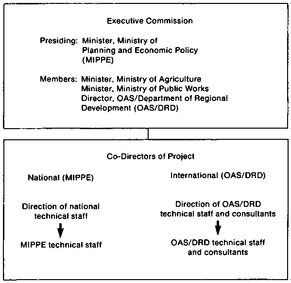
Figure 2 - CHRONOGRAM OF INTERNATIONAL TECHNICIAN ACTIVITIES
TABLE 1 - POLITICAL-ADMINISTRATIVE LEVELS
|
Level Administrative Division |
Head of Division |
Collegial Groups |
Membership |
|
1 Provincial Governments |
Governor |
a. Provincial Coordination Council |
Representatives of the corregimientos and members of the Provincial Technical Board. Presided over by the Governor. |
|
b. Provincial Technical Board |
Chief of the military zone, directors of regional agencies and departments and decentralized agencies of the central government. Coordinator: Provincial Planner (MIPPE). Presided over by the Governor. |
||
|
2 Districts (Counties) |
Mayor |
District Council |
Representatives of the corregimientos. Presided over by the Mayor. |
|
3 Corregimientos (Townships) |
Representative |
Town Board |
Representatives of the local boards. Presided over by the representative. |
|
4 Localities |
|
Local Boards |
Members of the community. |
A serious institutional conflict between MIPPE and the Ministry of Agriculture arose during Phase I over the Bayano Integrated Development Project in Panama Province. According to the Ministry of Agriculture, land development in the river basin would also affect the river's ability to feed the Bayano Dam, so the Darien study's area of action should not include the Bayano watershed. MIPPE disagreed. As an initial compromise, the study directors confined forestry and soil studies to the Darien province. Later, the executive commission restricted all activities to Darien.
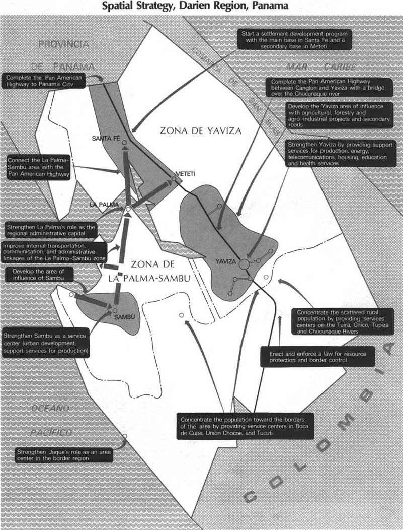
By early 1976, data on land use, soil capability, mineral and fishery resources, telecommunications, transportation, and overall regional development potential had been collected and analyzed. A small task force was set up within the technical unit to synthesize the results, extract and coordinate the principal findings of the sectoral studies, and prepare a regional strategy that complemented the 1976-80 national development plan. This task force concluded that the GDP of Darien province would triple and the economically active population would double within 20 years. Infrastructural needs would increase commensurately. Accordingly, the focal points of the proposed regional development strategy were to (1) strengthen the densely populated areas of La Palma-Chepigana and Yaviza-El Real-Boca de Cupe by improving production activities, services, and infrastructure; (2) improve control over squatter populations along the Pan American Highway and plan subsequent settlement; and (3) design a river-and-road network to connect the densely populated areas to each other and to the rest of Panama. (See Map 3.) The overall strategy was to direct development toward the areas that could best accommodate it over the long term and away from marginal areas where agro-industrial development would severely damage the resource base.
Potential Land Use, Darien Region, Panama
The forest inventory team during reconnaissance mapping of the Darien Region.
The forest inventory team with Darien colonists.
To implement this strategy, the technical unit proposed three alternatives. The first, based on a status quo investment level, focussed primarily on developing social services and physical infrastructure. The second assumed a substantial increase in capital expenditures to finance rapid growth in the production sector. The third, a compromise aimed at better balancing the development of the social and production-related sectors, entailed modest investment increases. The executive commission selected the third option, and this exercise spurred government to commit funds for implementing the study's recommendations.
The findings of the diagnostic studies, the proposed regional strategy, and the government's rationale for its investment commitment for the region were published in July 1976 in a joint OAS/Government of Panama report, "Present Situation and Perspectives on the Darien Region."
B. Phase I - Subregionalization and Project Identification
From the diagnostic phase, the technical unit had the data needed to divide the study area into subregions - a first step toward evaluating existing projects and identifying new ones. Subregionalization was a two-step process. First, homogeneity and polarization analyses were conducted. Second, practical political and operational aspects were considered.
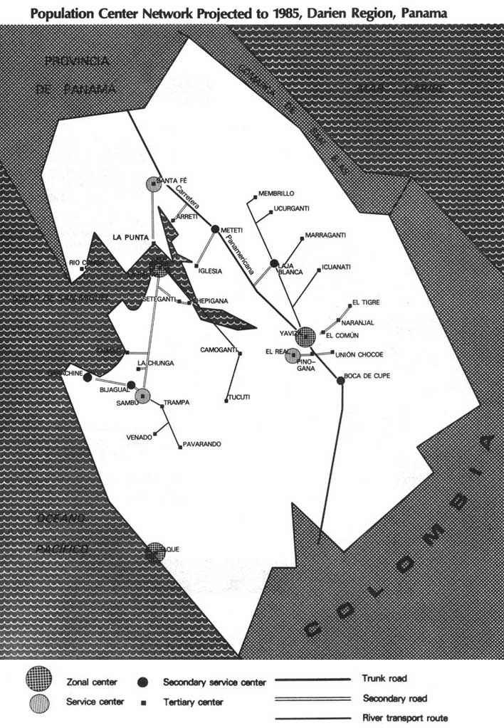
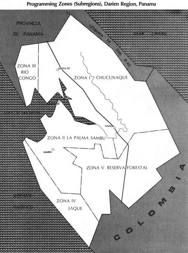
The subregions were relatively homogeneous units selected on the basis of such factors as soil quality, relief, climate, land use, and vegetation cover. The technical unit determined the limits of attraction and the reach of services around each of the principal population centers, both for the present and as projected to the years 1985 and 2000. (See Maps 4 and 5.) It then meshed these polarization analyses with the data on the boundaries of the political subdivisions to delineate five "programming zones." (See Map 6 and Table 2.)
Zones I and II, Chucunaque and La Palma-Sambú, were designated for immediate development since preliminary construction activities on the Pan American Highway had already led to uncontrolled settlement in this area, agricultural conditions were relatively favorable, and Yaviza was the region's fastest-growing town. The core areas of Zone II, La Palma and Sambú, contrasted dramatically. La Palma, the capital and largest town of the province, was politically powerful but economically stagnant. An impetus was needed to create jobs in this provincial center so as to reduce migration to Panama City and toward the Pan American Highway. In contrast, enterprising Choco Indians (Darienitas), and immigrants from other Panamanian provinces were pouring into Sambú despite the lack of service facilities there. The clear needs in Sambú were for a market-service center and social infrastructure.
Development activities would be deferred in Zones III and IV, mountainous and resource-poor areas in the northwest and southwest corners of the province. The mountainous Zone V was designated as a forest reserve that would serve as a buffer against migration and hoof-and-mouth disease from Colombia. (The U.S. Department of Agriculture had already dedicated US$7.7 million between 1974 and 1978 to the establishment of a similar disease barrier along the Pan American Highway in Colombia - Los Katios National Park.)
Table 2 - PROGRAMMING ZONES (Subregions)
|
Subregion |
Area ha. |
Population Density
|
Percentage of soil suitable for |
Key Development Considerations |
|
|
Annual Crops and Pasture |
Forestry |
||||
|
I. Chucunaque |
550,000 |
High to average |
54 |
33 |
Route of the Pan American Highway |
|
II-A* La Palma-Sambú |
286,000 |
High |
31 |
37 |
Proximity to the Gulf of San Miguel |
|
II-B* Rio Balsas |
121,000 |
Average |
70 |
21 |
Center of the province on the Balsas and Tuira rivers |
|
III. Rio Jaqué |
90,000 |
Average to low |
8 |
18 |
Pacific coastal location shared Colombia border |
|
IV. Rio Congo |
124,000 |
Low |
20 |
32 |
Proximity to Gulf of San Miguel |
|
V. Forest Reserve |
63,000 |
Low to nil |
11 |
45 |
Shared border with Colombia; Foot-and-mouth disease control |
Source: Based on Current Situation and Prospects of the Eastern Region - Darien (Preliminary Document), Government of Panama and OAS, July, 1976. La Palma-Sambú and Rio Balsas were originally delineated as separate zones and subsequently melded to become Zone II.
The results of Phase I were incorporated into a preliminary report that was submitted to the executive commission in June of 1976.
C. Phase II - Formulation of Interrelated Projects
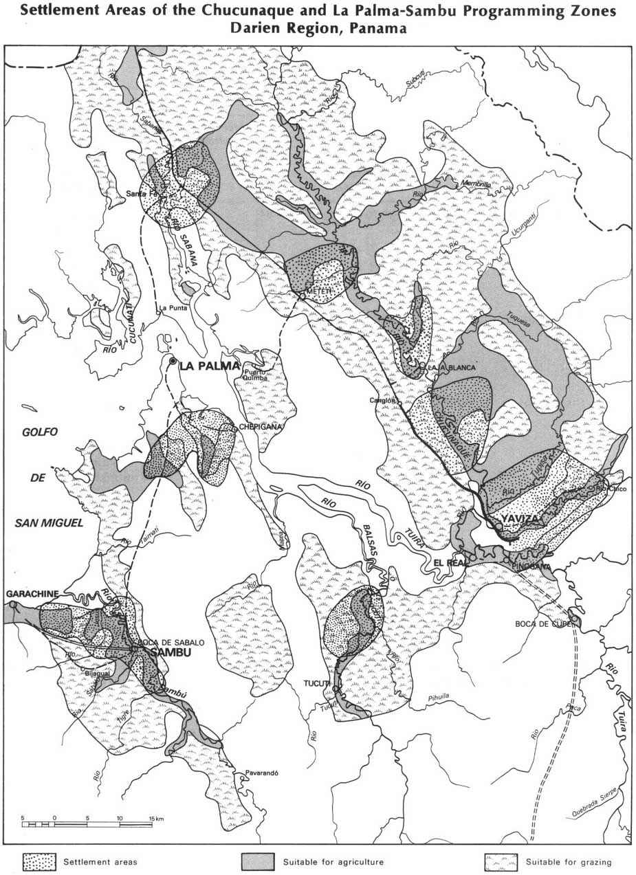
After the executive commission approved the programming zones in mid-1976, Phase II was launched and the technical unit concentrated on the two zones designated for immediate development. To identify promising settlement areas within each, it used six criteria: compliance with the regional strategy, the location of productive land, population forecasts and land-use trends, land-use regulations, the presence of squatter settlements, and the condition of the infrastructure. The region's low level of economic activity and limits on technological and entrepreneurial capabilities were also considered. The study team tentatively delineated five settlement areas in the Chucunaque subregion and three in La Palma-Sambú. (See Map 7 and Table 3.) It then identified the physical connections among the urban areas and specified the socio-economic infrastructure that each emerging community needed.
To select the optimal combination of production, service, and infrastructure projects to stimulate development, the technical unit relied on a master list drawn from its own work and discussions with local populations. Many proposals on this list had sprung from the project's close contact with authorities. The MIPPE provincial planner initially assigned to the study area worked intimately with local authorities and provincial community groups, and when MIPPE later made the planner a member of the technical unit, the unit functioned as the provincial planning office. This arrangement made the study team a prolific source of project ideas.
Table 3 - SETTLEMENT AREAS OF THE CHUCUNAQUE AND LA PALMA-SAMBU PROGRAMMING ZONES
|
Subregion and Zone |
Location |
Area ha. |
Population in 1977 |
Present Land Use |
Carrying Capacity (families)* | |
|
I. Chucunaque | ||||||
|
|
1. Yaviza |
Surrounding Yaviza |
21,000 |
2,700 |
Crops, livestock and forestry |
1,900 |
|
|
2. Canglón |
Mouth of Canglón river |
13,000 |
Sparse |
Crops, livestock and forestry |
1,200 |
|
|
3. Laja Blanca |
Valley of Chucunaque river |
5,100 |
Indian Sparse |
Crops |
460 |
|
|
4. Metetí |
Northeast of Pan American Highway |
7,200 |
Spontaneous colonies Sparse |
Crops |
660 |
|
|
5. Santa Fe |
Valley of the Sabana, Lara, and Hinostroza rivers, and slopes of the Tumagantí ravine |
11,200 |
Sparse |
Crops and services (highway juncture at La Palma) |
1,000 |
|
II. La Palma-Sambú | ||||||
|
|
1. Sambú |
South and west of Sambú |
12,250 |
1,100 |
Crops, livestock and forestry |
1,100 |
|
|
2. Setegantí |
South of La Palma |
9,200 |
Sparse |
Crops |
840 |
|
|
3. Rio Balsas |
North of the forest reserve |
7,000 |
Sparse |
Crops and forestry |
640 |
Source: Based on the "Integrated Development Project for the Eastern Region of Panama-Darien." OAS General Secretariat, Washington, D.C. 1977.* Family size of five persons.
To determine the minimum data needed to select the projects, the study team developed a manual on project identification and formulation. It also set common standards and formats for the use of the Panamanian agencies that were to supply data. In addition, the "project package" approach adopted for this study maximized savings by grouping complementary production and support projects together so as to improve their combined cost-benefit ratios. The technical unit supplemented the project packages with transport and communications projects designed to knit the settlement areas into a coherent region. (See Table 4 and Map 8.)
Four other project-selection criteria were also applied:
1. The use of relatively simple technologies adaptable to local labor and entrepreneurial capabilities;2. The rational use of natural resources;
3. The stimulation of population concentration through the creation of jobs and service facilities; and
4. The need to keep projects and packages relatively small in view of limited government funds and unknown international funding prospects.
Table 4 - SHORT-TERM INVESTMENT PROGRAM FOR ZONES I AND II
|
|
INVESTMENTS |
JOBS | |||||||
|
TYPE OF PROGRAM AND NUMBER OF PROJECTS |
ZONE I |
ZONE II |
COMMON TO BOTH ZONES |
TOTAL |
ZONE I |
ZONE II |
COMMON TO BOTH ZONES |
TOTAL | |
|
|
(thousands of 1978 dollars) |
| |||||||
|
AGRICULTURE (15 projects) |
5,558 |
515 |
- |
6,073 |
1,901 |
303 |
- |
2,204 | |
|
|
Corn (5) |
1,506(4) |
365(1) |
- |
1,871 |
1,094 |
265 |
- |
1,359 |
|
|
Plantain (4) |
997(3) |
150(1) |
- |
1,147 |
248 |
38 |
- |
286 |
|
|
Yucca (2) |
953(2) |
- |
- |
953 |
302 |
- |
- |
302 |
|
|
Yam (3) |
202(3) |
- |
- |
202 |
89 |
- |
- |
89 |
|
|
Pixbae, Hierba limón, and guandú |
1,900(1) |
- |
- |
1,900 |
168 |
- |
- |
168 |
|
CATTLE PRODUCTION (9 projects) |
1,194 |
1,785 |
- |
2,979 |
13 |
22 |
- |
35 | |
|
|
Breeding Centers (3) |
937(1) |
1,386(2) |
- |
2,323 |
4 |
8 |
- |
12 |
|
|
Demonstration Farms (3) |
69(1) |
104(2) |
- |
173 |
2 |
3 |
- |
5 |
|
|
Training Centers (3) |
188(1) |
295(2) |
- |
483 |
7 |
11 |
- |
18 |
|
FORESTRY (8 projects) |
414(5) |
66(3) |
- |
480 |
59 |
12 |
- |
71 | |
|
FISHING (1 project) |
- |
510(1) |
- |
510 |
- |
45 |
- |
45 | |
|
AGRO-INDUSTRY (4 projects) |
10,310(4) |
- |
- |
10,310 |
308 |
- |
- |
308 | |
|
PRIMARY ROADS (1 project) |
- |
- |
15,100(1) |
15,100 |
- |
- |
- |
- | |
|
SECONDARY ROADS (13 projects) |
2,006(8) |
1,103(4) |
40(1) |
3,149 |
- |
- |
10 |
10 | |
|
ENERGY (9 projects) |
1,366(5) |
784(4) |
- |
2,150 |
92 |
33 |
- |
125 | |
|
TELECOMMUNICATIONS (1 projects) |
- |
- |
1,972(1) |
1,972 |
- |
- |
14 |
14 | |
|
STORAGE FACILITIES (3 projects) |
88(1) |
258(1) |
795(1) |
1,141 |
16 |
26 |
23 |
65 | |
|
HOUSING AND URBANIZATION (9 projects) |
7,593(4) |
2,159(4) |
2,148(1) |
11,900 |
- |
- |
- |
- | |
|
EDUCATION (4 projects) |
260(2) |
100(2) |
- |
360 |
60 |
11 |
- |
71 | |
|
HEALTH (6 projects) |
74(2) |
66(2) |
3,500(2) |
3,640 |
53 |
46 |
196 |
295 | |
|
TECHNICAL ASSISTANCE (1 project) |
- |
- |
68(1) |
68 |
- |
- |
48 |
48 | |
|
TOTAL |
28,863 |
7,346 |
23,623 |
59,832 |
2,502 |
498 |
291 |
3,291 | |
During project identification and selection, the technical unit met frequently with counterpart technical staff in Panamanian agencies. These meetings helped open communication channels that eventually developed into assistance channels, especially at the middle levels of government.
The second round of formal training for counterpart agency staff also tied into project identification and selection, A four-week course on water and land development was organized by CIDIAT (the Inter-American Center for Integrated Development of Land and Water Resources),.and a more general, 13-week course on project formulation and evaluation was presented by CETREDE, In the CETREDE course, participants planned and evaluated several projects proposed for the Darien region - a wholesale market for farm products, a plywood factory, an access road between La Palma and the Pan American Highway, and a centralized maintenance and repair shop for motors. Some of the projects brought to a pre-feasibility level in this training course were later financed.
LIST OF PROPOSED PROJECTS PRODUCTIVE SECTORS
|
|
Corn | ||
|
|
Río Chico |
A.1.1 | |
|
|
El Salto |
A.1.2 | |
|
|
Río Tupiza |
A.1.3 | |
|
|
Río Balsas* |
A.1.4 | |
|
|
Santa Fe |
A.1.5 | |
|
|
Metetí* |
A.1.6 | |
|
|
Setegantí* |
A.1.7 | |
|
|
Celorio* |
A.1.8 | |
|
|
Sambú |
A.1.9 | |
|
|
La Chunga* |
A.1.10 | |
|
|
Plantain | ||
|
|
Yaviza |
A.2.1 | |
|
|
Río Chico |
A.2.2 | |
|
|
Río Balsas* |
A.2.3 | |
|
|
Arretí |
A.2.4 | |
|
|
Metetí* |
A.2.5 | |
|
|
Mogué |
A.2.6 | |
|
|
Río Jesús |
A.2.7 | |
|
|
Cattle | ||
|
|
Breeding farms |
| |
|
|
|
Santa Fe |
G.1.1 |
|
|
|
La Palma |
G.1.2 |
|
|
|
Sambú |
G.1.3 |
|
|
Demonstration farms |
| |
|
|
|
Santa Fe |
G.2.1 |
|
|
|
La Palma |
G.2.2 |
|
|
|
Sambú |
G.2.3 |
|
|
Training centers |
| |
|
|
|
Santa Fe |
G.3.1 |
|
|
|
La Palma |
G.3.2 |
|
|
|
Sambú |
G.3.3 |
|
|
Cassava | ||
|
|
Yaviza |
A.3.1 | |
|
|
Yaviza |
A.3.2 | |
|
|
Yam | ||
|
|
Pinogana |
A.4.1 | |
|
|
Laja Blanca |
A.4.2 | |
|
|
Yaviza |
A.4.3 | |
|
|
Santa Fe* |
A.4.4 | |
|
|
Metetí* |
A.4.5 | |
|
|
Chepigana* |
A.4.6 | |
|
|
Setegantí* |
A.4.7 | |
|
|
Río Jesús* |
A.4.8 | |
|
|
Taimatí* |
A.4.9 | |
|
|
Pixbae, Hierba-Limon. Guandu | ||
|
|
Yaviza |
A.5.1 | |
|
|
Fishery | ||
|
|
La Palma |
P.1 | |
|
|
Agro-industry | ||
|
|
Yaviza |
A-i.1 | |
|
|
Yaviza |
A-i.2 | |
|
|
Yaviza |
A-i.3 | |
|
|
Santa Fe |
A-i.4 | |
|
|
Forestry | ||
|
|
Yaviza |
F.1 | |
|
|
El Real |
F.2 | |
|
|
Río Chico |
F.3 | |
|
|
Camogantí |
F.4 | |
|
|
Sambú |
F.5 | |
|
|
Taimatí |
F.6 | |
|
|
La Punta |
F.7 | |
|
|
Yaviza |
F.8 | |
INFRASTRUCTURE AND SOCIAL SECTORS
|
TRANSPORTATION | ||
|
|
Trunk rood | |
|
|
Yaviza |
T.1 |
|
|
Secondary road | |
|
|
Metetí |
C.1 |
|
|
Setegantí |
C.2 |
|
|
Taimatí |
C.3 |
|
|
Sambú |
C.4 |
|
|
Garachiné |
C.5 |
|
|
Río Chico |
C.6 |
|
|
Tuira |
C.7 |
|
|
El Real |
C.8 |
|
|
Rio Pirre |
C.9 |
|
|
Laja Blanca |
C.10 |
|
|
Piriaque |
C.11 |
|
|
La Punta |
C.12 |
|
|
Ferry |
|
|
ENERGY | ||
|
|
Power plants | |
|
|
Yaviza |
E.E.1 |
|
|
Bajo Iglesias |
E.E.2 |
|
|
Metetí |
E.E.3 |
|
|
El Común |
E.E.4 |
|
|
Laja Blanca |
E.E.5 |
|
|
La Palma |
E.E.6 |
|
|
Sambú |
E.E.7 |
|
|
Garachiné |
E.E.8 |
|
|
Taimatí |
E.E.9 |
|
AGRICULTURAL PRODUCT STORAGE | ||
|
|
Purchasing center and warehouse facilities | |
|
|
La Palma, Sambú, El Real, Garachiné, Chepigana. Setegantí, Camogantí, Laja Blanca, Taimatí y Metetí |
A.P.1 |
|
|
Silo | |
|
|
Yaviza y Santa Fe |
A.P.2 |
|
TOWN DEVELOPMENT | ||
|
|
Housing | |
|
|
La Palma |
V.U.1 |
|
|
Yaviza |
V.U.2 |
|
|
Santa Fe y otras localidades |
V.U.3 |
|
|
Sambú |
V.U.4 |
|
|
El Tigre y El Común |
V.U.5 |
|
|
El Real |
V.U.6 |
|
|
Taimatí y Boca de Trampa |
V.U.7 |
|
|
Bijagual-Vallemón |
V.U.8 |
|
|
Corozal y otras localidades |
V.U.9 |
|
TELECOMMUNICATIONS | ||
|
|
Interurban |
T.C.1 |
|
|
La Palma |
|
|
|
Long distance |
T.C.1 |
|
|
Río Iglesias |
|
|
EDUCATION | ||
|
|
Construction of new schools | |
|
|
Yaviza, Santa Fe, Metetí, Laja Blanca, El Tigre, El Común, La Punta y otros. |
E.D.1 |
|
|
La Palma, Garachiné y Bijagual-Vallemón |
E.D.2 |
|
|
Reconstruction of existing schools | |
|
|
Metetí, Pinogana, El Tigre, El Común, Marragantí, Arretí, La Punta, Santa Fe y Pirre. |
E.D.3 |
|
|
La Palma, La Chunga, Pavarandó, Río Jesús, Venado. Bijagual Vallemón y Setegantí |
E.D.4 |
|
HEALTH | ||
|
|
Health centers | |
|
|
El Tigre, Metetí, El Salto, Laja Blanca, Río Iglesias, Villamor, Cucunatí, Puerto Quimba y Bajo Chiquito. |
S.1 |
|
|
Taimatí, Chepigana, Mogocénaga y Quintín |
S.2 |
|
|
Maternal-infant care facilities | |
|
|
Santa Fe |
S.3 |
|
|
Sambú y Tucutí |
S.4 |
|
|
Hospitals | |
|
|
Yaviza |
S.5 |
|
|
La Palma |
S.6 |
|
|
El Real* |
S.7 |
* Protects to be executed in the medium or long term
AREA OF POTENTIAL USE
Settlement areas
Two different approaches to natural resource management were taken. The first, which was ultimately dropped in favor of the second, was based on a type of ecosystem analysis applicable to both resource evaluation and project formulation. This integrated approach involved classifying the Darien area's ecosystems using the Holdridge Life-Zone method and describing the productive uses, possible products, use restrictions, and seasonal productivity fluctuations of each natural process and component. This approach was proposed in a workshop in Panama City for international and Panamanian specialists, study team members, and DRD representatives. Participants considered the impacts of converting forest land into livestock pastures, allowing more squatter settlements, clearing land near the Gulf of San Miguel, and preserving forest reserve areas. Disease control and some of the cultural practices of the Indian groups were also discussed. After some initial work, however, the national technicians rejected the approach as too theoretical. They decided instead to restrict environmental considerations to estimating potential environmental impacts of some of the more important projects proposed and to suggest ways to ameliorate these impacts. For example, the technical unit later recommended the proscriptive approach of setting up a Land Use Regulation Brigade under the Ministry of Agriculture to control land use along the eight-kilometer strip on both sides of Pan American Highway (per Law N°71) by regulating settlement on the lots and, if necessary, relocating settlers who were using the land inappropriately.
While the Panama-Darien regional studies were being conducted, comparable work was carried out in the Colombian Darien. Both countries wanted to develop the areas that would be opened by the connecting link of the Pan American Highway. But a formal bi-national approach to development of the shared region was not practicable. As an alternative, DRD helped Colombia study its part of the Darien, using the same methodologies and generating comparable data. The technical unit of the Panama-Darien study arranged to have its Colombian counterparts visit the Panamanian study area. A joint telecommunications project was eventually established,
D. Phase II - An Action Program for Short-Term Development
A set-back occurred in early 1978 when external financing agencies cut implementation funds substantially. In response, the executive commission decided to channel all available funding into Yaviza and Sambú - the two settlement areas whose natural resources, population density, economic potential, and political receptivity augured best for success. This decision was made at considerable political cost, but by now the executive commission had become convinced that only with a proper "critical minimum" of investment in a set of complementary projects could an area sustain economic growth.
The technical unit had already identified packages of proposals for self-sustaining projects that would create 3,400 jobs and substantially increase total gross production and income in the Yaviza and Sambú settlement areas. The packages also included proposals for new secondary roads; crop-storage, telecommunications, and electric power facilities; and education, health, and housing improvements.
Funding constraints made additional project adjustments necessary too. Besides the overall funding cut of almost 50 percent, MIPPE announced that the cutbacks would be most severe in the first two years. Thus, the executive commission further narrowed the study project's focus within Yaviza and Sambú and launched an "Immediate Action Program" focussed on projects with the greatest short-term potential to return investments, infrastructure that would be needed by the third year, and plans for obtaining additional funding. In the Immediate Action Program's first phase (years one and two), the Pan American Highway would be completed to Yaviza, and social services and agricultural production would be developed. In the second phase (years three through five), programs to build infrastructure, boost agriculture, and improve social services would continue, and an industrial development program would be initiated. In the five-year plan of activities laid out, investments and other activities were put in sequence and linked to the spatial strategy. (See Table 5.)
When the short-term and immediate action programs were refined, their effects on natural resources were calculated. Then the technical unit proposed adjustments to a number of projects:
· Agricultural projects. To decrease erosion, water-borne sedimentation, and eutrophication in the Gulf of San Miguel, corn should not be grown on specified soils and inter-planting practices should be adopted. Less mechanized crop-production techniques should be employed, wooded areas should be used as dikes and filters for run-off waters, plantain (rather than yucca) should be planted on erodible soils, and natural fertilizers and pesticides should be used.· Yucca starch processing. Since the processing plant proposed could contribute to eutrophication by discharging organically rich effluent into waterways, these residues should be converted into natural fertilizers. In addition, the sulfurous acid used in starch making should be limited.
· Sawmill operations. Pending further research on the forest's regenerative capacity, logging on highly erodible slopes should be confined to 500-meter contoured bands. Forest concessions should be monitored closely and support for the Ministry of Agriculture's Renewable Natural Resources Unit (RENARE) should be increased.
· Livestock projects. Since land would have to be cleared for pastures, livestock projects should be confined to flat or slightly sloping land and anti-erosion belts should be established along rivers and coasts. Raising livestock in corrals which requires less surface area per animal and thus permits crop rotation should be considered along with grazing in Sambú's forests, which would entail cutting down old trees, pruning branches, and using treated pulp for cattle feed, but not clear-cutting. (This technique is also more labor-intensive than traditional open-field livestock operations).
· Housing projects. Since management of household wastes and sewage effluents posed a serious problem, such "natural process technology" as fertilizing soil with treated wastes and using settlement tanks for water purification and fertilizer production should be studied.
Table 5 - FIVE-YEAR ACTION PLAN
|
1. Year 1 | |
|
|
- Continue work on the Pan-American Highway. |
|
|
- Implement corn and plantain banana growing projects in Rio Chico, Sambú, Yaviza, and Rio Jesus. |
|
|
- Implement forestry exploitation projects in Yaviza and Rio Chico areas. |
|
|
- Implement a project for small-scale fishermen in La Palma and the Gulf of San Miguel. |
|
|
- Construct secondary roads in the Rio Chico, Taimati, Sambú-Garachine and La Punta areas. |
|
|
- Build a power project In the El Comun area. |
|
|
- Build and repair schools In Yaviza, Santa Fe, and other communities. |
|
|
- Start a technical assistance and credit program for farmers of areas I and II. Carry out program In accordance with existing production programs. |
|
II. Year 2 | |
|
|
- Complete the Pan-American Highway up to Yaviza and a 5.5 km stretch running south from there. |
|
|
- Carry out a corn-growing project in the El Salto area. |
|
|
- Start a pilot livestock development plan in the Sambú area. |
|
|
- Carry out new forest development and exploitation projects in the El Real and Sambú areas. |
|
|
- Build an agro-industrial plant in Yaviza for selecting and packaging plantain bananas and processing of flour from plantain rejects. |
|
|
- Install a ferry between La Palma and La Punta. |
|
|
- Develop electric power projects In the Yaviza and Sambú areas. |
|
|
- Construct storage facilities for farm products in Yaviza and other localities. |
|
|
- Start an expansion and Improvement project for education centers In the Garachine area. |
|
|
- Start building a regional hospital in Yaviza. |
|
III. Year 3 | |
|
|
- Carry out corn, plantain, and banana growing projects in Rio Tupiza, Santa Fe, and Arreti. |
|
|
- Carry out projects for introducing modern methods for growing yucca and yams in the Yaviza and Pinogana areas. |
|
|
- Start model livestock development plan In the Santa Fe and La Palma areas. |
|
|
- Carry out an agro-industry project for caster oil extraction. |
|
|
- Construct secondary roads In the Seteganti and Sambú areas. |
|
|
- Build a power project in the Meteti area. |
|
|
- Start farm products storage programs in various localities. |
|
|
- Start a housing and urban development program in the Yaviza, Sambú, El Tigre, Tamiti-Trampa, and Bijagual-Vallemon areas. |
|
|
- Build and repair schools In La Palma. |
|
IV. Year 4 | |
|
|
- Carry out a yam-growing project in Laja Blanca. |
|
|
- Carry out a pixbae-lemon grass and pigeon pea raising program in the Yaviza area. |
|
|
- Carry out forestry exploitation projects in Camoganti and La Punta areas, and wood-processing projects In the Yaviza area. |
|
|
- Carry out an agro-Industrial project for processing yucca starch in the Yaviza area. |
|
|
- Build secondary roads In the Tuira and Piriaque areas. |
|
|
- Construct electric power projects in La Palma and Garachine. |
|
|
- Start a telecommunications project at the province level. |
|
|
- Start a housing and urban development program in the La Palma, Santa Fe and Meteti, and El Real areas, and other new localities. |
|
|
- Start a hospital project in the La Palma area. |
|
V. Year 5 | |
|
|
- Continue programs for growing corn, plantain bananas, yucca, yams, pixbae, lemon grass, pigeon peas, and caster oil plants. |
|
|
- Continue various livestock, forestry, and wood-processing programs. |
|
|
- Continue agro-industrial development projects and develop a project In Yaviza for canning hearts of palm and pigeon peas, and distilling essential oils. |
|
|
- Build secondary roads in the El Real, Rio Pirre, and Laja Blanca areas. |
|
|
- Continue developing power and telecommunication programs. |
|
|
- Continue various housing and urban development programs. |
|
|
- Continue the hospital construction program in the Yaviza and La Palma areas. |
E. Final Training Activities
These findings and recommendations were reviewed in a four-week training program co-sponsored by the study team, MIPPE, and the Inter-American Center for Regional Development (CINDER) (with headquarters in Maracaibo, Venezuela). Attended by nearly 30 experts from central planning, execution, and financing agencies, the training session also covered planning concepts and the management of regional plans and projects. Like earlier training activities, this program brought together the technical staff whose assistance and support would be critical during project implementation.
Programs and project proposals grew out of laborious efforts to reconcile possibilities, expectations, and constraints. From the outset the technical unit took institutional limitations into account, and from 1977 local institution-building was a high priority. Given extreme institutional deficiencies at the provincial level and the centralization of fund allocation, the team proposed setting up a new autonomous and decentralized organization, the "Agency for Development of the Eastern Region."
The new agency's goals would be to define policy, submit plans and programs to higher authorities, establish budgets, coordinate all development programs in Darien, and evaluate periodic progress reports. The Ministers of Agriculture, of Public Works, and of Public Health and Education and of MIPPE would participate in an executive commission that would oversee the agency while an executive committee would propose short-and mid-term activities and supervise their implementation. The regional directors of the same ministries would serve on the executive committee along with the provincial governor, the provincial vice-president of the National Assembly of Representatives, the chief of the military zone, and the MIPPE provincial planner. An executive director designated by the ministers would manage the agency. Capital resources would come from sectoral funds earmarked for the province, funds allocated to the agency itself, and income from services. The Minister of MIPPE would chair the highest commission and the MIPPE planner would chair the executive committee, so the new agency would have access to the national planning and budget offices.
The continuity of the planning process depended upon whether this new agency was set up and whether the Panamanian group trained during the study was kept together. In early 1978, MIPPE's minister decided to keep the technical team intact to follow up the planning project's recommendations and to identify additional sources of financing, but no decision about the new agency was made,
In 1978, the executive commission approved the final report of the technical unit, Project of Integrated Development of the Eastern Region of Panama-Darien, which DRD then published. A summary of this longer document was also circulated, and a film on the region and the project was produced. Later, the document's conclusions and recommendations were submitted to the Provincial Council, and the executive commission authorized DRD to publish the study's findings internationally,
In the face of worldwide recession, limits on the availability of external funding, and inflation, the Panamanian Government has decided to contain government spending and to focus on bringing high unemployment rates down. With the signing of the Panama Canal Treaties, it also shifted its attention to incorporating the Canal Zone into the national territory and developing the relatively rich central and western regions. For these reasons, government investment in the Darien province is unlikely to rise above recent levels.
Eastern Panama has now been designated as a potential reserve, and the government's current focus within Darien is to strengthen Yaviza's economy. The MIPPE provincial planning office continues to use the Darien study as a frame of reference, but the targets have not yet been met and only selected elements of the packages have been implemented.
More infrastructure projects than production projects have been launched. In particular, road-building has been extensive. New roads interconnect Sambú, Seteganti, Rio Balsas, Meteti, and Yaviza - five of the eight areas originally recommended for settlement. The La Palma road has been re-routed and extended, the Yaviza road extended, the Sambú road paved, and the El Real and Jaque roads improved. Most important, with Inter-American Development Bank financing, a link from the Pan American Highway to Yaviza will be built - a key recommendation of the study.
Several other projects are also under way. Eight three-year "basics" schools and the region's first vocational and technical institute have been established in the Darien, and the University of Panama has launched extension activities in the area. Through the health-facility construction program of the Integrated Health System, the number of doctors and nurses in Darien rose from 26 in 1977 to 45 in 1980. Programs to control hoof-and-mouth disease and cattle plague continue, and a checkpoint for confiscating animal products exists on the westbound road. Storage and silage facilities have been constructed by the Crops and Livestock Marketing Institute, and radio transmitters and microwave-relay stations have been installed in the townships.
On the other hand, financial constraints have stalled the National Housing Institute's housing program, construction of the Pan American Highway link to Colombia, and the natural resource-management proposals. The Ministry of Agriculture set up a Land-Use Regulation Brigade to control land use along eight-km strips on both sides of the Pan American Highway, but the new office merely grants lots to immigrants since funds are not available for removing illegal settlers. The agency tries to restrict grants to flat lands, but it does not have the capacity to monitor and control the approximately 6,000 new settlers the National Malaria Eradication Service estimates will enter the Darien. The recommendations of the environmental analysis have not been implemented either, most likely because they were add-on environmental impact considerations rather than integral parts of projects being formulated.
Attempts to find outside funding to establish the new provincial development institute have been unsuccessful. The failure of development corporations established in other Panamanian provinces may be one reason.
Indigenous planning capacity has definitely increased as a result of the Panama-Darien study. Before the project's national technical unit dissolved in 1979, it had begun diagnosing the resources of the Bocas del Toro province, thereby applying the expertise and experience acquired in the Darien study.
Whether the study team's remaining recommendations will be adopted, it is still to soon to say.
The DESIGN STAGE of the Darien study illustrated the benefits of:
1. Narrowing the focus of study as rapidly as possible by tentatively identifying the sectors, problems, or geographic areas that merit greatest attention. A rapid preliminary study designed to establish the terms of reference for the major study can effectively achieve this goal.2. Carefully tailoring the objectives to fit the available time and resources (funds, manpower, access to the area, and institutional capability). In the Darien study, the scope of work was cut down to a reasonable level by:
a. Limiting the time frame of the development plans;b. Limiting the scope of the study by eliminating all issues only marginally connected to the study; and
c. Targeting specific development zones within the study area.
3. Getting government to specify both the amount of capital that will be available to implement recommendations and the role of the area within national plans. In the Darien study, these obstacles were overcome by:
a. Asking the government to choose between three alternative investment levels; andb. Emphasizing that the Panamanian Government had already made the Darien region a high development priority within Panama's framework for regional development.
4. Defining environmental management explicitly before work on the project begins. Criticism that the ecosystem analysis approach to environmental problems was too theoretical led to "add-on" environmental studies that were the first to suffer under budget cuts, as well as to a proscriptive approach to environmental management that has failed for want of enforcement mechanisms.
The EXECUTION STAGE of the study showed the advantages of:
1. Collecting only that information needed to identify development problems and opportunities, to delineate development zones, and to generate project ideas. Despite streamlining, the diagnosis phase of the Darien projects still took too much of the study's total time and resources.2. Including an "urban" or market/service center plan and an associated transport plan, even in undeveloped regions. Given the high cost of energy, however, such plans in humid tropical areas should consider river as well as road transport.
3. Collecting project ideas from the outset of the study using all possible sources - existing project proposals, plans and project ideas of sectoral ministries, proposals of local citizens and groups, and fieldwork. In the Darien study, the team collected a surplus of ideas, then established a system for quickly evaluating, comparing, and selecting those that merited formulation at the pre-feasibility level.
4. Balancing production activities, production- support services, and social services so that the services spawn and support the production activities, which in turn generate enough wealth to pay for the services. In an area as undeveloped as the Darien, the need is for balanced "packages of projects" that collectively have a high cost-benefit ratio even though the ratio for some individual projects may be low.
5. Limiting the total cost of the proposed projects to the amount of capital available. When the investment budget for the Darien region had to be cut, the Minister of Planning decided to defer implementation of some entire "project packages" rather than implement one or two small projects in each locality, none of which would have been sufficient to catalyze local development.
6. Reducing environmental management problems by formulating and implementing mutually reinforcing and compatible projects.
a. To prevent the spread of hoof-and-mouth disease from Colombia, the regional plan incorporated Panama's plan to create a broad national park along the border between the two countries to serve as a buffer zone.b. To minimize damage to soils and vegetation caused by indiscriminate clearing and cultivation of new areas unsuitable for sustained agriculture, projects were formulated to provide agricultural extension, credit, transportation infrastructure, and social services which would help to guarantee the long-term settlement of new colonists in suitable areas.
The IMPLEMENTATION STAGE of the study illustrated the importance of:
1. Involving an optimal combination of agencies to make sure the study recommendations get carried out. These include (1) a planning agency with an integrated approach to development and access to the budget process and (2) the sectoral ministries that would implement most of the investment projects.2. Bringing together those who will be formulating projects with those who will later be responsible for financing and implementing them. Such connections were fostered formally and informally throughout the Darien study, especially through regional development seminars, which had twofold objectives: (1) training, and (2) establishing relationships between those responsible for project formulation and project implementation,
3. Creating an effective team through on-the-job training, supplementary courses and seminars, and the close working relationships required by the integrated approach. This approach worked so well that the Department of Planning kept the Darien planning team intact for almost a year to help implement the projects.
4. Recognizing the drawbacks of proposing a new agency to coordinate the implementation of the action programs. Doing so may have been reasonable in this case, given the weakness of local governments and the inability of the national sectoral agencies to manage multisectoral development. But it was a last-resort measure that did not work.
5. Understanding that only politically acceptable projects will be implemented and that the loss of political favor is an unavoidable hazard of development. The Darien study enjoyed political favor, but then national priority shifted to developing the Canal Zone. The planning study was not a failure because many of the proposals that addressed pressing needs for infrastructure have been implemented, but the packages of projects will not be implemented in their entirety until political winds change.
6. Sectorally integrating project implementation as well as project formulation. After early budget cutbacks, the size of the territory of each package of projects was reduced. With further cutbacks, however, priority was given to the implementation of transportation infrastructure projects and the idea of "package" implementation began to break down.
Domínguez, B.J. Estudios Económicos sobre la Industria del Papel de Panamá. Panamá, Universidad de Panamá, 1973.
Government of Panama/Organization of American States. Current Situation and Prospects of the Eastern Region - Darien. Preliminary document. Washington, D.C, OAS, July 1976.
Meganck, R.A. Colombia's National Parks: An Analysis of Management Problems and Perceived Values. Oregon State University, School of Forestry, 1975 (unpublished dissertation).
Mérida, J. Contribución a la Historia de la Exploración y Explotación Minera en Panamá. Panamá, Dirección General de Recursos Minerales, 1972.
OEA. Secretaría General/República de Panamá. Proyecto de Desarrollo Integrado de la Región Oriental de Panamá-Darién. Washington, D.C., OEA, 1978.
OEA. Secretaría General/República de Panamá. Proyecto de Desarrollo Integrado de la Región Oriental de Panamá-Darién: Situación Actual, Perspectiva y Propuesta de Acción para la Región Oriental de Panamá-Darién. Washington, D.C., OEA, September 1977.
Quirós, J.L. "Análisis de la Legislación sobre Recursos Minerales," Memorias de MACI. Panamá, 1967.
Quirós, J.L. "Investigaciones Mineras en Panamá." Revista MAC. Panamá, 1968.
Quirós, J.L. "La Política Minera en Panamá." Revista Tierra y Hombre, N°.3. Universidad de Panamá, 1973.
Republic of Panamá. Economic Policy and Planning Department. National Development Plan (1976-1980). Panamá, 1975.
República de Panamá. Ministerio de Planificación y Política Económica. Presupuesto de Inversiones Públicas. Panamá, 1975.
República de Panamá. La Planificación Provincial Preliminar. Panamá, 1975.
República de Panamá. Opciones Estratégicas para el Desarrollo Regional del País: 1980-1990. Panamá, November 1980.
U.S. Department of Transportation. Final Environmental Impact Assessments for Darién Gap Highway from Tocum, Panamá to Río León, Colombia. Washington, D.C., 1974.
![]()
![]()
![]()
![]()